List of Satellite Missions - ceos eo handbook
List of Satellite Missions - ceos eo handbook
List of Satellite Missions - ceos eo handbook
- No tags were found...
You also want an ePaper? Increase the reach of your titles
YUMPU automatically turns print PDFs into web optimized ePapers that Google loves.
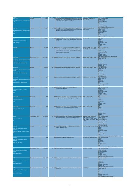
Mission Status Launch Date EOL Date Applications Instruments Orbit Details & URL<br />
DMSP F-19<br />
Approved Oct 2012 Oct 2017 The long-term met<strong>eo</strong>rological programme <strong>of</strong> the US Department OLS, SSM/IS, SSM, SSI/ES-3, Type: Sun-synchronous<br />
<strong>of</strong> Defense (DoD) - with the objective to collect and disseminate SSULI, SSUSI<br />
Altitude: 833 km<br />
Defense Met<strong>eo</strong>rological <strong>Satellite</strong> Program<br />
worldwide cloud cover data on a daily basis.<br />
Period: 101 mins<br />
F-19<br />
Inclination: 98.7 deg<br />
Repeat cycle:<br />
NOAA<br />
LST:<br />
Longitude (if g<strong>eo</strong>):<br />
Asc/desc: Ascending<br />
URL: dmsp.ngdc.noaa.gov/dmsp.html<br />
DMSP F-20<br />
Approved Jun 2014 Jun 2019 The long-term met<strong>eo</strong>rological programme <strong>of</strong> the US Department OLS, SSM/IS, SSM, SSI/ES-3, Type: Sun-synchronous<br />
<strong>of</strong> Defense (DoD) - with the objective to collect and disseminate SSULI, SSUSI<br />
Altitude: 850 km<br />
Defense Met<strong>eo</strong>rological <strong>Satellite</strong> Program<br />
worldwide cloud cover data on a daily basis.<br />
Period: 101 mins<br />
F-20<br />
Inclination: 98.7 deg<br />
Repeat cycle:<br />
NOAA<br />
LST:<br />
Longitude (if g<strong>eo</strong>):<br />
Asc/desc: Ascending<br />
URL: dmsp.ngdc.noaa.gov/dmsp.html<br />
DSCOVR<br />
Approved Jul 2014 Jul 2016 Measure a combination <strong>of</strong> solar phenomena and earth climate NISTAR, EPIC<br />
Type: TBD<br />
measurements. Provides 15 min warning for solar storms (CME)<br />
Altitude:<br />
Deep Space Climate Observatory<br />
events.<br />
Period:<br />
Inclination:<br />
NOAA / NASA<br />
Repeat cycle: 1 days<br />
LST:<br />
Longitude (if g<strong>eo</strong>):<br />
Asc/desc:<br />
URL:<br />
EarthCARE<br />
Approved Nov 2015 Nov 2018 To Improve the understanding <strong>of</strong> atmospheric cloud–aerosol CPR (EarthCARE), ATLID, BBR Type: Sun-synchronous<br />
interactions and <strong>of</strong> the Earth's radiative balance towards (EarthCARE), MSI (EarthCARE) Altitude: 393 km<br />
enhancing climate and numerical weather prediction models. The<br />
Period:<br />
ESA / JAXA<br />
2 active and 2 passive instruments <strong>of</strong> EarthCARE make unique<br />
Inclination: 97 deg<br />
data product synergies possible.<br />
Repeat cycle: 25 days<br />
LST:<br />
Longitude (if g<strong>eo</strong>):<br />
Asc/desc: Descending<br />
URL: www.esa.int/export/esaLP/earthcare.html<br />
Elektro-L N1<br />
Currently being flown 20 Jan 2011 Dec 2018 Hydromet<strong>eo</strong>rology, heliog<strong>eo</strong>physics, climatology, DCS, S&R. MSU-GS, DCS , GGAK-E, S&R Type: G<strong>eo</strong>stationary<br />
Altitude: 36000 km<br />
G<strong>eo</strong>stationary Operational Met<strong>eo</strong>rological<br />
Period:<br />
<strong>Satellite</strong> - 1<br />
Inclination:<br />
Repeat cycle:<br />
ROSHYDROMET / ROSKOSMOS<br />
LST:<br />
Longitude (if g<strong>eo</strong>): -76<br />
Asc/desc: N/A<br />
URL: planet.iitp.ru<br />
Elektro-L N2<br />
Approved Nov 2012 Nov 2018 Hydromet<strong>eo</strong>rology, heliog<strong>eo</strong>physics, climatology, DCS, S&R. MSU-GS, DCS , GGAK-E, S&R Type: G<strong>eo</strong>stationary<br />
Altitude: 36000 km<br />
G<strong>eo</strong>stationary Operational Met<strong>eo</strong>rological<br />
Period:<br />
<strong>Satellite</strong> - 2<br />
Inclination:<br />
Repeat cycle:<br />
ROSHYDROMET / ROSKOSMOS<br />
LST:<br />
Longitude (if g<strong>eo</strong>): -76<br />
Asc/desc: N/A<br />
URL: planet.iitp.ru<br />
Elektro-L N3<br />
Planned 2015 2022 Hydromet<strong>eo</strong>rology, heliog<strong>eo</strong>physics, climatology, DCS, S&R. MSU-GS, DCS , GGAK-E, S&R Type: G<strong>eo</strong>stationary<br />
Altitude: 36000 km<br />
G<strong>eo</strong>stationary Operational Met<strong>eo</strong>rological<br />
Period:<br />
<strong>Satellite</strong> - 3<br />
Inclination:<br />
Repeat cycle:<br />
ROSHYDROMET / ROSKOSMOS<br />
LST:<br />
Longitude (if g<strong>eo</strong>): 14.5<br />
Asc/desc: N/A<br />
URL: planet.iitp.ru<br />
EnMAP<br />
Approved Dec 2015 Dec 2020 Hyperspectral imaging, land surface, g<strong>eo</strong>logical and<br />
HSI<br />
Type: Sun-synchronous<br />
environmental investigation.<br />
Altitude: 650 km<br />
Environmental Mapping & Analysis<br />
Period: 97.5 mins<br />
Program<br />
Inclination:<br />
Repeat cycle: 21 days<br />
DLR<br />
LST: 11:00<br />
Longitude (if g<strong>eo</strong>):<br />
Asc/desc: Descending<br />
URL: www.enmap.org/<br />
Environsat-1<br />
Considered 2013 2017 Monitoring <strong>of</strong> greenhouse gases, aerosols and other atmospheric HRSS-1, HRVS-1A/-1B<br />
Type:<br />
trace gases which are responsible for global warming.<br />
Altitude:<br />
Environmental <strong>Satellite</strong> - 1<br />
Period:<br />
Inclination:<br />
ISRO<br />
Repeat cycle:<br />
LST:<br />
Longitude (if g<strong>eo</strong>):<br />
Asc/desc:<br />
URL:<br />
Environsat-2<br />
Considered 2016 2020 Monitoring <strong>of</strong> greenhouse gases, aerosols and other atmospheric HRSS-1, HRVS-1A/-1B<br />
Type:<br />
trace gases which are responsible for global warming.<br />
Altitude:<br />
Environmental <strong>Satellite</strong> - 2<br />
Period:<br />
Inclination:<br />
ISRO<br />
Repeat cycle:<br />
LST:<br />
Longitude (if g<strong>eo</strong>):<br />
Asc/desc:<br />
URL:<br />
Envisat<br />
Currently being flown 01 Mar 2002 Dec 2013 Physical oceanography, land surface, ice and snow, atmospheric DORIS-NG, MWR, ASAR (image Type: Sun-synchronous<br />
chemistry, atmospheric dynamics/water and energy cycles. mode), ASAR (wave mode), Altitude: 782 km<br />
Environmental <strong>Satellite</strong><br />
ENVISAT Comms, MERIS, MIPAS, Period: 100.5 mins<br />
ASAR, GOMOS, SCIAMACHY, RA-2, Inclination: 98.52 deg<br />
ESA<br />
AATSR<br />
Repeat cycle: 35 days<br />
LST: 10:30<br />
Longitude (if g<strong>eo</strong>):<br />
Asc/desc: Descending<br />
URL: envisat.esa.int/<br />
EPS-SG-a<br />
Planned 2019 2027 Met<strong>eo</strong>rology, climatology. EPS-SG-a carries the Sentinel-5 ATMS, METimage, IASI-NG, 3MI, RO Type: Sun-synchronous<br />
mission. 3 satellites (TBC).<br />
Altitude:<br />
EUMETSAT Polar System, second<br />
Period:<br />
generation<br />
Inclination:<br />
Repeat cycle: 29 days<br />
EUMETSAT / NOAA / DLR / EC / CNES /<br />
LST:<br />
ESA<br />
Longitude (if g<strong>eo</strong>):<br />
Asc/desc: N/A<br />
URL:<br />
www.eumetsat.int/Home/Main/<strong>Satellite</strong>s/index.htm?l=en?<br />
EPS-SG-b<br />
Planned 2020 2028 Met<strong>eo</strong>rology, climatology. 2 satellites (TBC). RO, MWI-Precip, MWI-Cloud, SCA Type: Sun-synchronous<br />
Altitude:<br />
EUMETSAT Polar System, second<br />
Period:<br />
generation<br />
Inclination:<br />
Repeat cycle:<br />
EUMETSAT / EC / ESA<br />
LST:<br />
Longitude (if g<strong>eo</strong>):<br />
Asc/desc:<br />
URL:<br />
www.eumetsat.int/Home/Main/<strong>Satellite</strong>s/index.htm?l=en?<br />
FY-1D<br />
Currently being flown 15 May 2002 Dec 2012 Met<strong>eo</strong>rology, environmental monitoring. MVISR (10 channels) Type: Sun-synchronous<br />
Altitude: 863 km<br />
FY-1D Polar-orbiting Met<strong>eo</strong>rological<br />
Period: 102.3 mins<br />
<strong>Satellite</strong><br />
Inclination: 98.8 deg<br />
Repeat cycle:<br />
NSMC-CMA / NRSCC<br />
LST: 9:00<br />
Longitude (if g<strong>eo</strong>):<br />
Asc/desc: Descending<br />
URL: fy3.satellite.cma.gov.cn/arssen/<br />
FY-2D<br />
Currently being flown 08 Dec 2006 Dec 2012 Met<strong>eo</strong>rology and environmental monitoring; data collection and IVISSR (FY-2)<br />
Type: G<strong>eo</strong>stationary<br />
redistribution.<br />
Altitude: 36000 km<br />
FY-2D G<strong>eo</strong>stationary Met<strong>eo</strong>rological<br />
Period:<br />
<strong>Satellite</strong><br />
Inclination:<br />
Repeat cycle:<br />
NSMC-CMA / NRSCC<br />
LST:<br />
Longitude (if g<strong>eo</strong>): -86.5<br />
Asc/desc: N/A<br />
URL: fy3.satellite.cma.gov.cn/arssen/<br />
FY-2E<br />
Currently being flown 26 Dec 2008 Dec 2012 Met<strong>eo</strong>rology and environmental monitoring; data collection and IVISSR (FY-2)<br />
Type: G<strong>eo</strong>stationary<br />
redistribution.<br />
Altitude: 36000 km<br />
FY-2E G<strong>eo</strong>stationary Met<strong>eo</strong>rological<br />
Period:<br />
<strong>Satellite</strong><br />
Inclination:<br />
Repeat cycle:<br />
NSMC-CMA / NRSCC<br />
LST:<br />
Longitude (if g<strong>eo</strong>): -105<br />
Asc/desc: N/A<br />
URL: fy3.satellite.cma.gov.cn/arssen/<br />
7


