

List of Satellite Missions - ceos eo handbook
List of Satellite Missions - ceos eo handbook
List of Satellite Missions - ceos eo handbook
- No tags were found...

You also want an ePaper? Increase the reach of your titles
YUMPU automatically turns print PDFs into web optimized ePapers that Google loves.
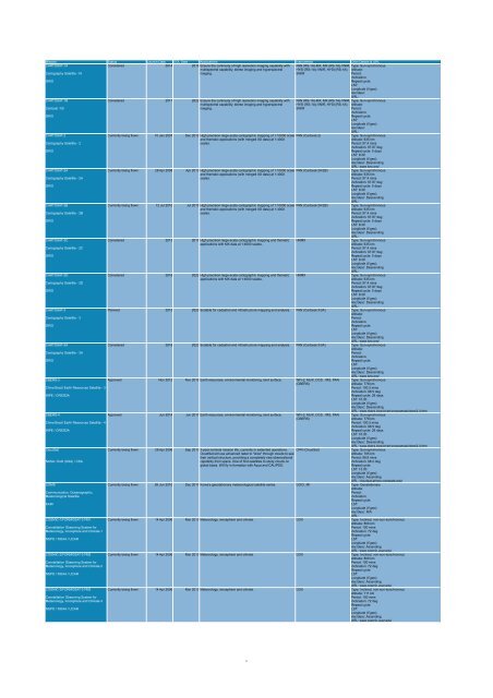
Mission Status Launch Date EOL Date Applications Instruments Orbit Details & URL<br />
CARTOSAT-1A<br />
Considered 2014 2019 Ensure the continuity <strong>of</strong> high resolution imaging capability with PAN (RS-1A)-MX, MX (RS-1A)-VNIR, Type: Sun-synchronous<br />
multispectral capability, ster<strong>eo</strong> imaging and hyperspectral HYSI (RS-1A)-VNIR, HYSI (RS-1A)- Altitude:<br />
Cartography <strong>Satellite</strong> -1A<br />
imaging.<br />
SWIR<br />
Period:<br />
Inclination:<br />
ISRO<br />
Repeat cycle:<br />
LST:<br />
Longitude (if g<strong>eo</strong>):<br />
Asc/desc:<br />
URL:<br />
CARTOSAT-1B<br />
Considered 2017 2022 Ensure the continuity <strong>of</strong> high resolution imaging capability with PAN (RS-1A)-MX, MX (RS-1A)-VNIR, Type: Sun-synchronous<br />
multispectral capability, ster<strong>eo</strong> imaging and hyperspectral HYSI (RS-1A)-VNIR, HYSI (RS-1A)- Altitude:<br />
Cartosat -1B<br />
imaging.<br />
SWIR<br />
Period:<br />
Inclination:<br />
ISRO<br />
Repeat cycle:<br />
LST:<br />
Longitude (if g<strong>eo</strong>):<br />
Asc/desc:<br />
URL:<br />
CARTOSAT-2<br />
Currently being flown 10 Jan 2007 Dec 2012 High precision large-scale cartographic mapping <strong>of</strong> 1:10000 scale PAN (Cartosat-2)<br />
Type: Sun-synchronous<br />
and thematic applications (with merged XS data) at 1:4000<br />
Altitude: 635 km<br />
Cartography <strong>Satellite</strong> - 2<br />
scales.<br />
Period: 97.4 mins<br />
Inclination: 97.87 deg<br />
ISRO<br />
Repeat cycle: 5 days<br />
LST: 9:30<br />
Longitude (if g<strong>eo</strong>):<br />
Asc/desc: Descending<br />
URL: www.isro.org/<br />
CARTOSAT-2A<br />
Currently being flown 28 Apr 2008 Apr 2013 High precision large-scale cartographic mapping <strong>of</strong> 1:10000 scale PAN (Cartosat-2A/2B)<br />
Type: Sun-synchronous<br />
and thematic applications (with merged XS data) at 1:4000<br />
Altitude: 635 km<br />
Cartography <strong>Satellite</strong> - 2A<br />
scales.<br />
Period: 97.4 mins<br />
Inclination: 97.87 deg<br />
ISRO<br />
Repeat cycle: 5 days<br />
LST: 9:30<br />
Longitude (if g<strong>eo</strong>):<br />
Asc/desc: Descending<br />
URL:<br />
CARTOSAT-2B<br />
Currently being flown 12 Jul 2010 Jul 2015 High precision large-scale cartographic mapping <strong>of</strong> 1:10000 scale PAN (Cartosat-2A/2B)<br />
Type: Sun-synchronous<br />
and thematic applications (with merged XS data) at 1:4000<br />
Altitude: 635 km<br />
Cartography <strong>Satellite</strong> - 2B<br />
scales.<br />
Period: 97.4 mins<br />
Inclination: 97.87 deg<br />
ISRO<br />
Repeat cycle: 5 days<br />
LST: 9:30<br />
Longitude (if g<strong>eo</strong>):<br />
Asc/desc: Descending<br />
URL:<br />
CARTOSAT-2C<br />
Considered 2013 2017 High precision large-scale cartographic mapping and thematic HRMX<br />
Type: Sun-synchronous<br />
applications with MX data at 1:4000 scales.<br />
Altitude: 635 km<br />
Cartography <strong>Satellite</strong> - 2C<br />
Period: 97.4 mins<br />
Inclination: 97.87 deg<br />
ISRO<br />
Repeat cycle: 5 days<br />
LST: 9:30<br />
Longitude (if g<strong>eo</strong>):<br />
Asc/desc: Descending<br />
URL:<br />
CARTOSAT-2D<br />
Considered 2016 2022 High precision large-scale cartographic mapping and thematic HRMX<br />
Type: Sun-synchronous<br />
applications with MX data at 1:4000 scales.<br />
Altitude: 635 km<br />
Cartography <strong>Satellite</strong> - 2D<br />
Period: 97.4 mins<br />
Inclination: 97.87 deg<br />
ISRO<br />
Repeat cycle: 5 days<br />
LST: 9:30<br />
Longitude (if g<strong>eo</strong>):<br />
Asc/desc: Descending<br />
URL:<br />
CARTOSAT-3<br />
Planned 2015 2020 Suitable for cadastral and infrastructure mapping and analysis. PAN (Cartosat-3/3A) Type: Sun-synchronous<br />
Altitude:<br />
Cartography <strong>Satellite</strong> - 3<br />
Period:<br />
Inclination:<br />
ISRO<br />
Repeat cycle:<br />
LST:<br />
Longitude (if g<strong>eo</strong>):<br />
Asc/desc: Descending<br />
URL: www.isro.org/<br />
CARTOSAT-3A<br />
Considered 2018 2023 Suitable for cadastral and infrastructure mapping and analysis. PAN (Cartosat-3/3A) Type: Sun-synchronous<br />
Altitude:<br />
Cartography <strong>Satellite</strong> - 3A<br />
Period:<br />
Inclination:<br />
ISRO<br />
Repeat cycle:<br />
LST:<br />
Longitude (if g<strong>eo</strong>):<br />
Asc/desc: Descending<br />
URL: www.isro.org/<br />
CBERS-3<br />
Approved Nov 2012 Nov 2015 Earth resources, environmental monitoring, land surface. WFI-2, MUX, DCS , IRS, PAN Type: Sun-synchronous<br />
(CBERS)<br />
Altitude: 778 km<br />
China Brazil Earth Resources <strong>Satellite</strong> - 3<br />
Period: 100.3 mins<br />
Inclination: 98.5 deg<br />
INPE / CRESDA<br />
Repeat cycle: 26 days<br />
LST: 10:30<br />
Longitude (if g<strong>eo</strong>):<br />
Asc/desc: Descending<br />
URL: www.cbers.inpe.br/en/programas/cbers3-4.htm<br />
CBERS-4<br />
Approved Jun 2014 Jun 2017 Earth resources, environmental monitoring, land surface. WFI-2, MUX, DCS , IRS, PAN Type: Sun-synchronous<br />
(CBERS)<br />
Altitude: 778 km<br />
China Brazil Earth Resources <strong>Satellite</strong> - 4<br />
Period: 100.3 mins<br />
Inclination: 98.5 deg<br />
INPE / CRESDA<br />
Repeat cycle: 26 days<br />
LST: 10:30<br />
Longitude (if g<strong>eo</strong>):<br />
Asc/desc: Descending<br />
URL: www.cbers.inpe.br/en/programas/cbers3-4.htm<br />
CloudSat<br />
Currently being flown 28 Apr 2006 Sep 2013 3-year nominal mission life, currently in extended operations. CPR (CloudSat)<br />
Type: Sun-synchronous<br />
CloudSat will use advanced radar to "slice" through clouds to see<br />
Altitude: 705 km<br />
their vertical structure, providing a completely new observational<br />
Period: 98.8 mins<br />
NASA / DoD (USA) / CSA<br />
capability from space. One <strong>of</strong> first satellites to study clouds on<br />
Inclination: 98.2 deg<br />
global basis. Will fly in formation with Aqua and CALIPSO.<br />
Repeat cycle:<br />
LST: 13:30<br />
Longitude (if g<strong>eo</strong>):<br />
Asc/desc: Ascending<br />
URL: cloudsat.atmos.colostate.edu/<br />
COMS<br />
Currently being flown 26 Jun 2010 Dec 2017 Korea's g<strong>eo</strong>stationary met<strong>eo</strong>rological satellite series. GOCI, MI Type: G<strong>eo</strong>stationary<br />
Altitude:<br />
Communication, Oceanographic,<br />
Period:<br />
Met<strong>eo</strong>rological <strong>Satellite</strong><br />
Inclination:<br />
Repeat cycle:<br />
KARI<br />
LST:<br />
Longitude (if g<strong>eo</strong>):<br />
Asc/desc: N/A<br />
URL:<br />
COSMIC-1/FORMOSAT-3 FM1<br />
Currently being flown 14 Apr 2006 Mar 2013 Met<strong>eo</strong>rology, ionosphere and climate. GOX Type: Inclined, non-sun-synchronous<br />
Altitude: 800 km<br />
Constellation Observing System for<br />
Period: 100 mins<br />
Met<strong>eo</strong>rology, Ionosphere and Climate-1<br />
Inclination: 72 deg<br />
Repeat cycle:<br />
NSPO / NOAA / UCAR<br />
LST:<br />
Longitude (if g<strong>eo</strong>):<br />
Asc/desc: Ascending<br />
URL: www.cosmic.ucar.edu/<br />
COSMIC-2/FORMOSAT-3 FM2<br />
Currently being flown 14 Apr 2006 Mar 2013 Met<strong>eo</strong>rology, ionosphere and climate. GOX Type: Inclined, non-sun-synchronous<br />
Altitude: 800 km<br />
Constellation Observing System for<br />
Period: 100 mins<br />
Met<strong>eo</strong>rology, Ionosphere and Climate-2<br />
Inclination: 72 deg<br />
Repeat cycle:<br />
NSPO / NOAA / UCAR<br />
LST:<br />
Longitude (if g<strong>eo</strong>):<br />
Asc/desc: Ascending<br />
URL: www.cosmic.ucar.edu/<br />
COSMIC-3/FORMOSAT-3 FM3<br />
Currently being flown 14 Apr 2006 Mar 2013 Met<strong>eo</strong>rology, ionosphere and climate. GOX Type: Inclined, non-sun-synchronous<br />
Altitude: 711 km<br />
Constellation Observing System for<br />
Period: 100 mins<br />
Met<strong>eo</strong>rology, Ionosphere and Climate-3<br />
Inclination: 72 deg<br />
Repeat cycle:<br />
NSPO / NOAA / UCAR<br />
LST:<br />
Longitude (if g<strong>eo</strong>):<br />
Asc/desc: Ascending<br />
URL: www.cosmic.ucar.edu/<br />
5


