List of Satellite Missions - ceos eo handbook
List of Satellite Missions - ceos eo handbook
List of Satellite Missions - ceos eo handbook
- No tags were found...
You also want an ePaper? Increase the reach of your titles
YUMPU automatically turns print PDFs into web optimized ePapers that Google loves.
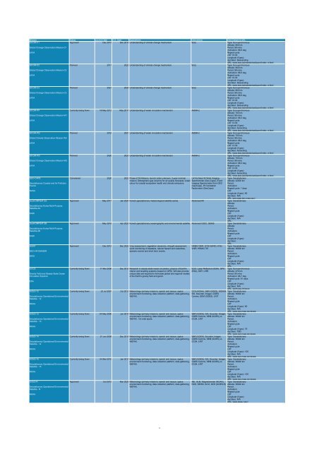
Mission Status Launch Date EOL Date Applications Instruments Orbit Details & URL<br />
GCOM-C1<br />
Approved Dec 2013 Dec 2018 Understanding <strong>of</strong> climate change mechanism. SGLI Type: Sun-synchronous<br />
Altitude: 800 km<br />
Global Change Observation Mission-C1<br />
Period: 98 mins<br />
Inclination: 98.6 deg<br />
JAXA<br />
Repeat cycle:<br />
LST: 10:30<br />
Longitude (if g<strong>eo</strong>):<br />
Asc/desc: Descending<br />
URL: www.jaxa.jp/projects/sat/gcom/index_e.html<br />
GCOM-C2<br />
Planned 2017 2022 Understanding <strong>of</strong> climate change mechanism. SGLI Type: Sun-synchronous<br />
Altitude: 800 km<br />
Global Change Observation Mission-C2<br />
Period: 98 mins<br />
Inclination: 98.6 deg<br />
JAXA<br />
Repeat cycle:<br />
LST: 10:30<br />
Longitude (if g<strong>eo</strong>):<br />
Asc/desc: Descending<br />
URL: www.jaxa.jp/projects/sat/gcom/index_e.html<br />
GCOM-C3<br />
Planned 2021 2026 Understanding <strong>of</strong> climate change mechanism. SGLI Type: Sun-synchronous<br />
Altitude: 800 km<br />
Global Change Observation Mission-C3<br />
Period: 98 mins<br />
Inclination: 98.6 deg<br />
JAXA<br />
Repeat cycle:<br />
LST: 10:30<br />
Longitude (if g<strong>eo</strong>):<br />
Asc/desc: Descending<br />
URL: www.jaxa.jp/projects/sat/gcom/index_e.html<br />
GCOM-W1<br />
Currently being flown 18 May 2012 May 2017 Understanding <strong>of</strong> water circulation mechanism. AMSR-2 Type: Sun-synchronous<br />
Altitude: 700 km<br />
Global Change Observation Mission-W1<br />
Period: 98 mins<br />
Inclination: 98.2 deg<br />
JAXA<br />
Repeat cycle:<br />
LST: 13:30<br />
Longitude (if g<strong>eo</strong>):<br />
Asc/desc: Ascending<br />
URL: www.jaxa.jp/projects/sat/gcom/index_e.html<br />
GCOM-W2<br />
Planned 2016 2021 Understanding <strong>of</strong> water circulation mechanism. AMSR-2 Type: Sun-synchronous<br />
Altitude: 700 km<br />
Global Climate Observation Mission-W2<br />
Period: 98 mins<br />
Inclination: 98.2 deg<br />
JAXA<br />
Repeat cycle:<br />
LST: 13:30<br />
Longitude (if g<strong>eo</strong>):<br />
Asc/desc: Ascending<br />
URL: www.jaxa.jp/projects/sat/gcom/index_e.html<br />
GCOM-W3<br />
Planned 2020 2025 Understanding <strong>of</strong> water circulation mechanism. AMSR-2 Type: Sun-synchronous<br />
Altitude: 700 km<br />
Global Change Observation Mission-W3<br />
Period: 98 mins<br />
Inclination: 98.2 deg<br />
JAXA<br />
Repeat cycle:<br />
LST: 13:30<br />
Longitude (if g<strong>eo</strong>):<br />
Asc/desc: Ascending<br />
URL: www.jaxa.jp/projects/sat/gcom/index_e.html<br />
GEO-CAPE<br />
Considered 2020 2023 Phase-2 DS Mission, launch order unknown, 3-year nominal UV/Vis Near IR Wide Imaging Type: G<strong>eo</strong>stationary<br />
mission. Atmospheric gas columns for air quality forecasts; ocean Spectrometer (G<strong>eo</strong>-Cape), Event Altitude: 42000 km<br />
G<strong>eo</strong>stationary Coastal and Air Pollution<br />
colour for coastal ecosystem health and climate emissions. Imaging Spectrometer from GEO Period:<br />
Events<br />
(G<strong>eo</strong>Cape), IR Correlation<br />
Inclination:<br />
Radiometer (G<strong>eo</strong>Cape)<br />
Repeat cycle: 1 days<br />
NASA<br />
LST:<br />
Longitude (if g<strong>eo</strong>): 80<br />
Asc/desc: N/A<br />
URL: g<strong>eo</strong>-cape.larc.nasa.gov/<br />
G<strong>eo</strong>KOMPSAT-2A<br />
Approved May 2017 Jan 2024 Korea's g<strong>eo</strong>stationary met<strong>eo</strong>rological satellite series. Advanced MI Type: G<strong>eo</strong>stationary<br />
Altitude:<br />
G<strong>eo</strong>stationary Korea Multi-Purpose<br />
Period:<br />
<strong>Satellite</strong>-2A<br />
Inclination:<br />
Repeat cycle:<br />
KARI<br />
LST:<br />
Longitude (if g<strong>eo</strong>):<br />
Asc/desc: N/A<br />
URL:<br />
G<strong>eo</strong>KOMPSAT-2B<br />
Approved May 2018 Apr 2025 Korea's g<strong>eo</strong>stationary oceanographic and environmental satellite. Advanced GOCI, GEMS Type: G<strong>eo</strong>stationary<br />
Altitude:<br />
G<strong>eo</strong>stationary Korea Multi-Purpose<br />
Period:<br />
<strong>Satellite</strong>-2B<br />
Inclination:<br />
Repeat cycle:<br />
KARI<br />
LST:<br />
Longitude (if g<strong>eo</strong>):<br />
Asc/desc:<br />
URL:<br />
GISAT<br />
Approved Dec 2013 Dec 2022 Crop assessment, vegetation dynamics, drought assessment; HRMX-VNIR, HYSI-SWIR, HYSI- Type: G<strong>eo</strong>stationary<br />
quick monitoring <strong>of</strong> disasters, natural hazard and calamities, VNIR, HRMX-TIR<br />
Altitude: 36000 km<br />
GEO HR IMAGER<br />
episodic events and short term events.<br />
Period:<br />
Inclination:<br />
ISRO<br />
Repeat cycle:<br />
LST:<br />
Longitude (if g<strong>eo</strong>):<br />
Asc/desc: N/A<br />
URL:<br />
GOCE<br />
Currently being flown 17 Mar 2009 Dec 2012 Research in steady-state ocean circulation, physics <strong>of</strong> Earth's EGG, Laser Reflectors (ESA), GPS Type: Sun-synchronous<br />
interior and levelling systems (based on GPS). Will also provide (ESA), SSTI, LRR<br />
Altitude: 270 km<br />
Gravity Field and Steady-State Ocean<br />
unique data set required to formulate global and regional models<br />
Period: 90 mins<br />
Circulation Explorer<br />
<strong>of</strong> the Earth's gravity field and g<strong>eo</strong>id.<br />
Inclination: 96.7 deg<br />
Repeat cycle: 61 days<br />
ESA<br />
LST:<br />
Longitude (if g<strong>eo</strong>):<br />
Asc/desc: N/A<br />
URL: earth.esa.int/goce<br />
GOES-12<br />
Currently being flown 23 Jul 2001 Oct 2013 Met<strong>eo</strong>rology (primary mission), search and rescue, space DCS (NOAA), S&R (GOES), WEFAX, Type: G<strong>eo</strong>stationary<br />
environment monitoring, data collection platform, data gathering, SXI, Sounder, Imager, GOES Altitude: 36000 km<br />
G<strong>eo</strong>stationary Operational Environmental<br />
WEFAX.<br />
Comms, SEM (GOES), LRIT Period:<br />
<strong>Satellite</strong> - 12<br />
Inclination:<br />
Repeat cycle:<br />
NOAA<br />
LST:<br />
Longitude (if g<strong>eo</strong>): 60<br />
Asc/desc: N/A<br />
URL: www.oso.noaa.gov/goes/<br />
GOES-13<br />
Currently being flown 24 May 2006 Jun 2015 Met<strong>eo</strong>rology (primary mission), search and rescue, space S&R (GOES), SXI, Sounder, Imager, Type: G<strong>eo</strong>stationary<br />
environment monitoring, data collection platform, data gathering, GOES Comms, SEM (GOES), A- Altitude: 36000 km<br />
G<strong>eo</strong>stationary Operational Environmental<br />
WEFAX. On-orbit spare.<br />
DCS4, LRIT<br />
Period:<br />
<strong>Satellite</strong> - 13<br />
Inclination:<br />
Repeat cycle:<br />
NOAA<br />
LST:<br />
Longitude (if g<strong>eo</strong>): 75<br />
Asc/desc: TBD<br />
URL: www.oso.noaa.gov/goes<br />
GOES-14<br />
Currently being flown 27 Jun 2009 Dec 2019 Met<strong>eo</strong>rology (primary mission), search and rescue, space S&R (GOES), Sounder, Imager, Type: G<strong>eo</strong>stationary<br />
environment monitoring, data collection platform, data gathering, GOES Comms, SEM (GOES), A- Altitude: 36000 km<br />
G<strong>eo</strong>stationary Operational Environmental<br />
WEFAX.<br />
DCS4, LRIT<br />
Period:<br />
<strong>Satellite</strong> - 14<br />
Inclination:<br />
Repeat cycle:<br />
NOAA<br />
LST:<br />
Longitude (if g<strong>eo</strong>): 105<br />
Asc/desc: N/A<br />
URL: www.oso.noaa.gov/goes/<br />
GOES-15<br />
Currently being flown 04 Mar 2010 Jan 2017 Met<strong>eo</strong>rology (primary mission), search and rescue, space S&R (GOES), SXI, Sounder, Imager, Type: G<strong>eo</strong>stationary<br />
environment monitoring, data collection platform, data gathering, GOES Comms, SEM (GOES), A- Altitude: 36000 km<br />
G<strong>eo</strong>stationary Operational Environmental<br />
WEFAX.<br />
DCS4, LRIT<br />
Period:<br />
<strong>Satellite</strong> - 15<br />
Inclination:<br />
Repeat cycle:<br />
NOAA<br />
LST:<br />
Longitude (if g<strong>eo</strong>): 105<br />
Asc/desc: N/A<br />
URL: www.oso.noaa.gov/goes/<br />
GOES-R<br />
Approved Oct 2015 Mar 2025 Met<strong>eo</strong>rology (primary mission), search and rescue, space ABI, GLM, Magnetometer (NOAA), Type: G<strong>eo</strong>stationary<br />
environment monitoring, data collection platform, data gathering, EXIS, SEISS, SUVI, DCS (GOES-R) Altitude: 36000 km<br />
G<strong>eo</strong>stationary Operational Environmental<br />
WEFAX.<br />
Period:<br />
<strong>Satellite</strong> - R<br />
Inclination:<br />
Repeat cycle:<br />
NOAA<br />
LST:<br />
Longitude (if g<strong>eo</strong>):<br />
Asc/desc: N/A<br />
URL: www.goes-r.gov/<br />
9


