

landbased
List of Satellite Missions (alphabetical) - ceos eo handbook
List of Satellite Missions (alphabetical) - ceos eo handbook
- No tags were found...

You also want an ePaper? Increase the reach of your titles
YUMPU automatically turns print PDFs into web optimized ePapers that Google loves.
A<br />
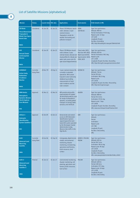
List of Satellite Missions (alphabetical)<br />
Mission Status Launch date EOL date Applications Instruments Orbit details & URL<br />
3D Winds<br />
Three Dimensional<br />
Tropospheric<br />
Winds from Space<br />
Based Lidar<br />
NASA<br />
Considered 01 Jan 30 01 Jan 33 Phase-2 DS Mission, launch<br />
order unknown, 3-year<br />
nominal mission.<br />
Tropospheric winds for<br />
weather forecasting and<br />
pollution transport<br />
HDWL<br />
(3D Winds)<br />
Type: Sun-synchronous<br />
Altitude: 400 km<br />
Period: Inclination: 97.03 deg<br />
Repeat cycle: 12 days<br />
LST: 6:00<br />
Longitude (if geo):<br />
Asc/desc: Ascending<br />
URL: http://decadal.gsfc.nasa.gov/3dwinds.html<br />
ACE<br />
Aerosol Clouds<br />
and Ecosystem<br />
Mission<br />
NASA<br />
Considered 01 Jan 20 01 Jan 23 Phase-2 DS Mission, launch<br />
order unknown, 3-year<br />
nominal mission. Aerosol and<br />
cloud profiles for climate and<br />
water cycle; ocean color for<br />
open ocean biogeochemistry<br />
Cloud radar (ACE),<br />
Next Gen APS (ACE),<br />
Multi-band UV/VIS<br />
Spectrometer (ACE),<br />
HSRL (ACE)<br />
Type: Sun-synchronous<br />
Altitude: 650 km<br />
Period: Inclination: 98.2 deg<br />
Repeat cycle:<br />
LST: 13:00<br />
Longitude (if geo): Asc/desc: Ascending<br />
URL: http://dsm.gsfc.nasa.gov/ace/science.html<br />
ACRIMSAT<br />
Active Cavity<br />
Radiometer<br />
Irradiance<br />
Monitor<br />
NASA<br />
Currently<br />
being flown<br />
20 Dec 99 20 Sep 11 5-year nominal mission life,<br />
currently in extended<br />
operations. Will sustain<br />
long-term solar luminosity<br />
database by providing<br />
measurements of total<br />
solar irradiance and the<br />
solar constant<br />
ACRIM III<br />
Type: Sun-synchronous<br />
Altitude: 716 km<br />
Period: 90 mins<br />
Inclination: 98.13 deg<br />
Repeat cycle:<br />
LST: 10:50<br />
Longitude (if geo): Asc/desc: Descending<br />
URL: http://acrim.jpl.nasa.gov<br />
ADM-Aeolus<br />
Atmospheric<br />
Dynamics Mission<br />
(Earth Explorer<br />
Core Mission)<br />
ESA<br />
Approved 01 Nov 11 01 Nov 14 Will provide wind profile<br />
measurements for global<br />
3D wind field products used<br />
for study of atmospheric<br />
dynamics, including global<br />
transport of energy, water,<br />
aerosols, and chemicals<br />
ALADIN<br />
Type: Sun-synchronous<br />
Altitude: 408 km<br />
Period: 92.5 mins<br />
Inclination: 97.01 deg<br />
Repeat cycle: 7 days<br />
LST: 18:00<br />
Longitude (if geo): Asc/desc: Ascending<br />
URL: www.esa.int/export/esaLP/aeolus.html<br />
AISSat-1<br />
Automatic<br />
Identification<br />
System Satellite-1<br />
NSC<br />
Approved 01 Oct 09 01 Oct 12 Demonstrate and extend<br />
access to AIS (Automatic<br />
Identification System)<br />
signals beyond the <strong>landbased</strong><br />
AIS system operated<br />
by the Norwegian Coastal<br />
Administration today.<br />
Observe ship traffic in the<br />
High North.<br />
SDR<br />
Type: Sun-synchronous<br />
Altitude:<br />
Period:<br />
Inclination:<br />
Repeat cycle:<br />
LST: TBD<br />
Longitude (if geo):<br />
Asc/desc: Descending<br />
URL:<br />
ALOS<br />
Advanced Land<br />
Observing<br />
Satellite<br />
JAXA<br />
Currently<br />
being flown<br />
24 Jan 06 01 Sep 10 Cartography, digital terrain<br />
models, environmental<br />
monitoring, disaster<br />
monitoring, civil planning,<br />
agriculture and forestry,<br />
Earth resources, land<br />
surface<br />
AVNIR-2, PALSAR,<br />
PRISM<br />
Type: Sun-synchronous<br />
Altitude: 692 km<br />
Period: 98.7 mins<br />
Inclination: 98.16 deg<br />
Repeat cycle: 46 days<br />
LST: 10:30<br />
Longitude (if geo):<br />
Asc/desc: Descending<br />
URL: www.jaxa.jp/projects/sat/alos/index_e.html<br />
ALOS-2<br />
Advanced Land<br />
Observing<br />
Satellite-2<br />
JAXA<br />
Planned 01 Jan 12 01 Jan 17 environmental monitoring,<br />
disaster monitoring, civil<br />
planning, agriculture and<br />
forestry, Earth resources,<br />
land surface<br />
PALSAR<br />
Type: Sun-synchronous<br />
Altitude: 628 km<br />
Period: 100 mins<br />
Inclination: 97.9 deg<br />
Repeat cycle: 14 days<br />
LST: 12:00<br />
Longitude (if geo):<br />
Asc/desc: Descending<br />
166
8 Catalogue of Satellite Missions<br />
A|B<br />
Mission Status Launch date EOL date Applications Instruments Orbit details & URL<br />
ALOS-3<br />
Advanced Land<br />
Observing<br />
Satellite-3<br />
JAXA<br />
Planned 01 Jan 13 01 Jan 18 Cartography, digital terrain<br />
models, environmental<br />
monitoring, disaster<br />
monitoring, civil planning,<br />
agriculture and forestry,<br />
Earth resources, land<br />
surface<br />
Optical or<br />
HyperSpectral<br />
(TBD)<br />
Type: Sun-synchronous<br />
Altitude:<br />
Period:<br />
Inclination:<br />
Repeat cycle:<br />
LST: 13:30<br />
Longitude (if geo):<br />
Asc/desc: Descending<br />
URL:<br />
AMAZÔNIA-1<br />
Remote Sensing<br />
Satellite 1<br />
INPE<br />
Approved 01 Dec 11 01 Dec 15 Earth resources,<br />
environmental monitoring,<br />
land surface<br />
OBA<br />
Type: Inclined, non-sunsynchronous<br />
Altitude: 905 km<br />
Period: 103.2 mins<br />
Inclination: 0 deg<br />
Repeat cycle:<br />
LST:<br />
Longitude (if geo):<br />
Asc/desc: Descending<br />
URL: www.inpe.br/programas/mecb/default.htm<br />
Aqua<br />
Aqua (formerly<br />
EOS PM-1)<br />
NASA / JAXA /<br />
BNISS / INPE<br />
Currently<br />
being flown<br />
04 May 02 30 Sep 11 6-year nominal mission life,<br />
currently in extended<br />
operations.<br />
Atmosphericdynamics/water<br />
and energy cycles,<br />
cloudformation,<br />
precipitationand<br />
radiativeproperties,<br />
air/seafluxes of energy<br />
andmoisture, sea ice<br />
extentand heat exchange<br />
with the atmosphere.<br />
Option of 705km or 438km<br />
orbit altitude.<br />
AIRS, MODIS,<br />
CERES, HSB, AMSR-<br />
E, AMSU-A<br />
Type: Sun-synchronous<br />
Altitude: 705 km<br />
Period: 98.8 mins<br />
Inclination: 98.2 deg<br />
Repeat cycle: 16 days<br />
LST: 13:30<br />
Longitude (if geo):<br />
Asc/desc: Ascending<br />
URL: www.gsfc.nasa.gov<br />
ASCENDS<br />
Active Sensing of<br />
CO 2 Emissions<br />
over Nights, Days,<br />
and Seasons<br />
NASA<br />
Considered 01 Jan 20 01 Jan 23 Phase-2 DS Mission, launch<br />
order unknown, 3-year<br />
nominal mission. Day/night,<br />
all-latitude, all-season CO 2<br />
column integrals for climate<br />
emissions<br />
CO 2 LIDAR<br />
(ASCENDS)<br />
Type: Sun-synchronous<br />
Altitude: 450 km<br />
Period: 97.3 mins<br />
Inclination:<br />
Repeat cycle:<br />
LST: 10:30<br />
Longitude (if geo):<br />
Asc/desc: Ascending<br />
URL: http://cce.nasa.gov/ascends/index.htm<br />
Aura<br />
Aura (formerly<br />
EOS Chemistry)<br />
NASA / NSO / FMI<br />
/ BNSC<br />
Currently<br />
being flown<br />
15 Jul 04 30 Sep 11 5-year nominal mission life,<br />
currently in extended<br />
operations. Chemistry and<br />
dynamics of Earth’s<br />
atmosphere from the<br />
ground through the<br />
mesosphere.<br />
MLS (EOS-Aura),<br />
TES, HiRDLS, OMI<br />
Type: Sun-synchronous<br />
Altitude: 705 km<br />
Period: 98.8 mins<br />
Inclination: 98.2 deg<br />
Repeat cycle: 16 days<br />
LST: 13:38<br />
Longitude (if geo):<br />
Asc/desc: Ascending<br />
URL: http://aura.gsfc.nasa.gov<br />
BJ-1<br />
Beijing-1 Small<br />
Satellite<br />
NRSCC<br />
Currently<br />
being flown<br />
27 Oct 05 27 Oct 10 Earth Observation MSI (BJ-1), PAN<br />
(BJ-1)<br />
Type: Sun-synchronous<br />
Altitude: 686 km<br />
Period:<br />
Inclination: 98.17 deg<br />
Repeat cycle:<br />
LST:<br />
Longitude (if geo):<br />
Asc/desc: TBD<br />
URL: www.blmit.com.cn<br />
167
C<br />
Mission Status Launch date EOL date Applications Instruments Orbit details & URL<br />
CALIPSO<br />
Currently<br />
being flown<br />
Cloud-Aerosol<br />
Lidar and Infrared<br />
Pathfinder<br />
Satellite<br />
Observations<br />
NASA / CNES<br />
28 Apr 06 30 Sep 11 3-year nominal mission life,<br />
currently in extended<br />
operations. Measurements<br />
of aerosol & cloud<br />
properties for climate<br />
predictions, using a 3<br />
channel lidar and passive<br />
instruments in formation<br />
with Aqua and CloudSat for<br />
coincident observations of<br />
radiative fluxes and<br />
atmospheric state.<br />
WFC, IIR, CALIOP<br />
Type: Sun-synchronous<br />
Altitude: 705 km<br />
Period: 98.8 mins<br />
Inclination: 98.2 deg<br />
Repeat cycle:<br />
LST: 13:30<br />
Longitude (if geo):<br />
Asc/desc: Ascending<br />
URL: www-calipso.larc.nasa.gov<br />
CARTOSAT-1<br />
Cartography<br />
Satellite - 1 (IRS<br />
P5)<br />
ISRO<br />
Currently<br />
being flown<br />
05 May 05 31 Dec 09 High precision large-scale<br />
cartographic mapping of<br />
1:10000 scale and thematic<br />
applications (with merged<br />
XS data) at 1:4000 scales<br />
PAN (Cartosat-1)<br />
Type: Sun-synchronous<br />
Altitude: 618 km<br />
Period: 97 mins<br />
Inclination: 97.87 deg<br />
Repeat cycle: 5 days<br />
LST: 10:30<br />
Longitude (if geo):<br />
Asc/desc: Descending<br />
URL: www.isro.org<br />
CARTOSAT-2<br />
Cartography<br />
Satellite - 2<br />
ISRO<br />
Currently<br />
being flown<br />
10 Jan 07 01 Jan 11 High precision large-scale<br />
cartographic mapping of<br />
1:10000 scale and thematic<br />
applications (with merged<br />
XS data) at 1:4000 scales<br />
PAN (Cartosat-2)<br />
Type: Sun-synchronous<br />
Altitude: 635 km<br />
Period: 97.4 mins<br />
Inclination: 97.87 deg<br />
Repeat cycle: 5 days<br />
LST: 9:30<br />
Longitude (if geo):<br />
Asc/desc: Descending<br />
URL: www.isro.org<br />
CARTOSAT-3<br />
Cartography<br />
Satellite - 3<br />
ISRO<br />
Planned 01 Jan 11 01 Jan 15 Suitable for cadastral and<br />
infrastructure mapping and<br />
analysis<br />
PAN (Cartosat-3)<br />
Type: Sun-synchronous<br />
Altitude:<br />
Period:<br />
Inclination:<br />
Repeat cycle:<br />
LST:<br />
Longitude (if geo):<br />
Asc/desc: Descending<br />
URL: www.isro.org<br />
CBERS-2B<br />
China Brazil Earth<br />
Resources<br />
Satellite - 2B<br />
CRESDA / INPE<br />
Currently<br />
being flown<br />
19 Sep 07 20 Oct 10 Earth resources,<br />
environmental monitoring,<br />
land surface (joint with<br />
INPE)<br />
WFI, CCD, DCS<br />
(CAST), HRC<br />
Type: Sun-synchronous<br />
Altitude: 778 km<br />
Period:<br />
Inclination: 98.5 deg<br />
Repeat cycle: 26 days<br />
LST: 10:30<br />
Longitude (if geo):<br />
Asc/desc: Descending<br />
URL: www.cast.cn/ &<br />
www.cbers.inpe.br/en/programas/cbers1-2.htm<br />
CBERS-3<br />
China Brazil Earth<br />
Resources<br />
Satellite - 3<br />
CRESDA / INPE<br />
Approved 20 Oct 10 21 Oct 13 Earth resources,<br />
environmental monitoring,<br />
land surface (joint with<br />
INPE)<br />
WFI-2, MUX, DCS<br />
(CAST), IRS, PAN<br />
Type: Sun-synchronous<br />
Altitude: 778 km<br />
Period: 100.26 mins<br />
Inclination: 98.5 deg<br />
Repeat cycle: 26 days<br />
LST: 11:50<br />
Longitude (if geo):<br />
Asc/desc: Descending<br />
URL: www.cast.cn/ &<br />
www.cbers.inpe.br/en/programas/cbers3-4.htm<br />
168
8 Catalogue of Satellite Missions<br />
C<br />
Mission Status Launch date EOL date Applications Instruments Orbit details & URL<br />
CBERS-4<br />
China Brazil Earth<br />
Resources<br />
Satellite - 4<br />
CRESDA / INPE<br />
Approved 20 Oct 13 20 Oct 16 Earth resources,<br />
environmental<br />
monitoring, land surface<br />
(joint with INPE)<br />
WFI-2, MUX, IRS,<br />
PAN<br />
Type: Sun-synchronous<br />
Altitude: 778 km<br />
Period: 100.26 mins<br />
Inclination: 98.5 deg<br />
Repeat cycle: 26 days<br />
LST: 12:50<br />
Longitude (if geo):<br />
Asc/desc: Descending<br />
URL: www.cast.cn/ &<br />
www.cbers.inpe.br/en/programas/cbers3-4.htm<br />
CHAMP<br />
Challenging Mini-<br />
Satellite Payload<br />
for Geophysical<br />
Research and<br />
Application<br />
DLR<br />
Currently<br />
being flown<br />
15 Jul 00 31 May 10 Gravity field, precise<br />
geoid, magnetic field,<br />
atmospheric physics<br />
CHAMP Gravity Type: Inclined, non-sunsynchronous<br />
Package<br />
Altitude: 315 km<br />
(Accelerometer+GPS), Period:<br />
CHAMP<br />
Inclination: 87 deg<br />
Magnetometry Repeat cycle:<br />
Package (1 Scalar + LST:<br />
2 Vector<br />
Longitude (if geo):<br />
Magnetometer), Asc/desc: N/A<br />
CHAMP GPS URL: http://op.gfz-potsdam.de/champ/index_CHAMP.html<br />
Sounder<br />
CHINOOK<br />
CSA<br />
Considered 01 Dec 10 01 Dec 15 Stratospheric wind<br />
measurements and<br />
ozone flux<br />
SWIFT<br />
Type: Sun-synchronous<br />
Altitude:<br />
Period:<br />
Inclination:<br />
Repeat cycle:<br />
LST: 6:00<br />
Longitude (if geo):<br />
Asc/desc: Ascending<br />
URL:<br />
CLARREO<br />
Climate Absolute<br />
Radiance and<br />
Refractivity<br />
Observatory<br />
NASA / NOAA<br />
Considered 01 Jan 17 01 Jan 20 Phase-1 DS Mission<br />
(follows SMAP and<br />
ICESAT-2), 3-year<br />
nominal mission. Solar<br />
radiation: spectrally<br />
resolved forcing and<br />
response of the climate<br />
system<br />
Occultation GNSS<br />
Receiver (CLARREO),<br />
IR spectrometer<br />
(CLARREO), Solar<br />
reflected<br />
spectrometer<br />
(CLARREO)<br />
Type: Inclined, non-sunsynchronous<br />
Altitude: 650 km<br />
Period:<br />
Inclination: 90 deg<br />
Repeat cycle: 365 days<br />
LST:<br />
Longitude (if geo):<br />
Asc/desc:<br />
URL: http://nasascience.nasa.gov/missions/clarreo<br />
CloudSat<br />
NASA / CSA<br />
Currently<br />
being flown<br />
28 Apr 06 30 Sep 11 3-year nominal mission<br />
life, currently in<br />
extended operations.<br />
CloudSat will use<br />
advanced radar to<br />
"slice" through clouds to<br />
see their vertical<br />
structure, providing a<br />
completely new<br />
observational capability<br />
from space. One of first<br />
satellites to study clouds<br />
on global basis. Will fly<br />
in formation with Aqua<br />
and CALIPSO.<br />
CPR (CloudSat)<br />
Type: Sun-synchronous<br />
Altitude: 705 km<br />
Period: 98.8 mins<br />
Inclination: 98.2 deg<br />
Repeat cycle:<br />
LST: 13:30<br />
Longitude (if geo):<br />
Asc/desc: Ascending<br />
URL: http://cloudsat.atmos.colostate.edu<br />
COMS<br />
Communication,<br />
Oceanographic,<br />
Meteorological<br />
Satellite<br />
KARI<br />
Approved 30 Nov 09 01 Nov 16 Korea's geostationary<br />
meterological satellite<br />
series<br />
GOCI, MI<br />
Type: Geostationary<br />
Altitude:<br />
Period:<br />
Inclination:<br />
Repeat cycle:<br />
LST:<br />
Longitude (if geo):<br />
Asc/desc: N/A<br />
URL:<br />
169
C<br />
Mission Status Launch date EOL date Applications Instruments Orbit details & URL<br />
CORIOLIS<br />
DoD (USA) / NASA<br />
Currently<br />
being flown<br />
06 Jan 03 01 Jan 09 Validating space bourne<br />
multi-channel polarametric<br />
radiometry for wind vector<br />
measurements<br />
WindSat<br />
Type: Sun-synchronous<br />
Altitude: 840 km<br />
Period: 101 mins<br />
Inclination: 98.7 deg<br />
Repeat cycle:<br />
LST: 18:00<br />
Longitude (if geo):<br />
Asc/desc: Ascending<br />
URL: www.nrl.navy.mil/WindSat<br />
COSMIC-1/<br />
FORMOSAT-3 FM1<br />
Constellation<br />
Observing System<br />
for Meteorology,<br />
Ionosphere and<br />
Climate-1<br />
NSPO / NOAA /<br />
UCAR<br />
Currently<br />
being flown<br />
14 Apr 06 15 Mar 11 Meteorology, Ionosphere<br />
and climate<br />
GOX<br />
Type: Inclined, non-sunsynchronous<br />
Altitude: 800 km<br />
Period: 100 mins<br />
Inclination: 72 deg<br />
Repeat cycle:<br />
LST:<br />
Longitude (if geo):<br />
Asc/desc: Ascending<br />
URL: www.cosmic.ucar.edu<br />
COSMIC-2/<br />
FORMOSAT-3 FM2<br />
Constellation<br />
Observing System<br />
for Meteorology,<br />
Ionosphere and<br />
Climate-2<br />
NSPO / NOAA /<br />
UCAR<br />
Currently<br />
being flown<br />
14 Apr 06 15 Mar 11 Meteorology, Ionosphere<br />
and climate<br />
GOX<br />
Type: Inclined, non-sunsynchronous<br />
Altitude: 800 km<br />
Period: 100 mins<br />
Inclination: 72 deg<br />
Repeat cycle:<br />
LST:<br />
Longitude (if geo):<br />
Asc/desc: Ascending<br />
URL: www.cosmic.ucar.edu<br />
COSMIC-3/<br />
FORMOSAT-3 FM3<br />
Constellation<br />
Observing System<br />
for Meteorology,<br />
Ionosphere and<br />
Climate-3<br />
NSPO / NOAA /<br />
UCAR<br />
Currently<br />
being flown<br />
14 Apr 06 15 Mar 11 Meteorology, Ionosphere<br />
and climate<br />
GOX<br />
Type: Inclined, non-sunsynchronous<br />
Altitude: 711 km<br />
Period: 100 mins<br />
Inclination: 72 deg<br />
Repeat cycle:<br />
LST:<br />
Longitude (if geo):<br />
Asc/desc: Ascending<br />
URL: www.cosmic.ucar.edu<br />
COSMIC-4/<br />
FORMOSAT-3 FM4<br />
Constellation<br />
Observing System<br />
for Meteorology,<br />
Ionosphere and<br />
Climate-4<br />
NSPO / NOAA /<br />
UCAR<br />
Currently<br />
being flown<br />
14 Apr 06 15 Mar 11 Meteorology, Ionosphere<br />
and climate<br />
GOX<br />
Type: Inclined, non-sunsynchronous<br />
Altitude: 800 km<br />
Period: 100 mins<br />
Inclination: 72 deg<br />
Repeat cycle:<br />
LST:<br />
Longitude (if geo):<br />
Asc/desc: Ascending<br />
URL: www.cosmic.ucar.edu<br />
COSMIC-5/<br />
FORMOSAT-3 FM5<br />
Constellation<br />
Observing System<br />
for Meteorology,<br />
Ionosphere and<br />
Climate-5<br />
NSPO / NOAA /<br />
UCAR<br />
Currently<br />
being flown<br />
14 Apr 06 15 Mar 11 Meteorology, Ionosphere<br />
and climate<br />
GOX<br />
Type: Inclined, non-sunsynchronous<br />
Altitude: 800 km<br />
Period: 100 mins<br />
Inclination: 72 deg<br />
Repeat cycle:<br />
LST:<br />
Longitude (if geo):<br />
Asc/desc: Ascending<br />
URL: www.cosmic.ucar.edu<br />
170
8 Catalogue of Satellite Missions<br />
C<br />
Mission Status Launch date EOL date Applications Instruments Orbit details & URL<br />
COSMIC-6/<br />
FORMOSAT-3 FM6<br />
Constellation<br />
Observing System<br />
for Meteorology,<br />
Ionosphere and<br />
Climate-6<br />
NSPO / NOAA /<br />
UCAR<br />
Currently<br />
being flown<br />
14 Apr 06 15 Mar 11 Meteorology,<br />
Ionosphere and climate<br />
GOX<br />
Type: Inclined, non-sunsynchronous<br />
Altitude: 800 km<br />
Period: 100 mins<br />
Inclination: 72 deg<br />
Repeat cycle:<br />
LST:<br />
Longitude (if geo):<br />
Asc/desc: Ascending<br />
URL: www.cosmic.ucar.edu<br />
COSMO-SkyMed 1 Currently<br />
COnstellation of being flown<br />
small Satellites<br />
for Mediterranean<br />
basin Observation 1<br />
ASI / MiD (Italy)<br />
COSMO-SkyMed 2 Currently<br />
COnstellation of being flown<br />
small Satellites<br />
for Mediterranean<br />
basin Observation 2<br />
ASI / MiD (Italy)<br />
COSMO-SkyMed 3 Currently<br />
COnstellation of being flown<br />
small Satellites<br />
for Mediterranean<br />
basin Observation 3<br />
ASI / MiD (Italy)<br />
08 Jun 07 08 Jun 14 Environmental<br />
monitoring, surveillance<br />
and risk management<br />
applications,<br />
environmental resources<br />
management, maritime<br />
management, earth<br />
topographic mapping,<br />
law enforcement,<br />
informative / science<br />
applications<br />
SAR 2000<br />
09 Dec 07 09 Dec 14 Environmental<br />
monitoring, surveillance<br />
and risk management<br />
applications,<br />
environmental resources<br />
management, maritime<br />
management, earth<br />
topographic mapping,<br />
law enforcement,<br />
informative / science<br />
applications<br />
SAR 2000<br />
27 Oct 08 27 Oct 15 Environmental<br />
monitoring, surveillance<br />
and risk management<br />
applications,<br />
environmental resources<br />
management, maritime<br />
management, earth<br />
topographic mapping,<br />
law enforcement,<br />
informative / science<br />
applications<br />
SAR 2000<br />
Type: Sun-synchronous<br />
Altitude: 622 km<br />
Period: 97.15 mins<br />
Inclination: 97.8 deg<br />
Repeat cycle: 16 days<br />
LST: 6:00<br />
Longitude (if geo):<br />
Asc/desc: Ascending<br />
URL:<br />
www.asi.it/SiteEN/ContentSite.aspx?Area=Osservare+la+Terra<br />
Type: Sun-synchronous<br />
Altitude: 622 km<br />
Period: 97.15 mins<br />
Inclination: 97.8 deg<br />
Repeat cycle: 16 days<br />
LST: 6:00<br />
Longitude (if geo):<br />
Asc/desc: Ascending<br />
URL:<br />
www.asi.it/SiteEN/ContentSite.aspx?Area=Osservare+la+Terra<br />
Type: Sun-synchronous<br />
Altitude: 622 km<br />
Period: 97.15 mins<br />
Inclination: 97.8 deg<br />
Repeat cycle: 16 days<br />
LST: 6:00<br />
Longitude (if geo):<br />
Asc/desc: Ascending<br />
URL:<br />
www.asi.it/SiteEN/ContentSite.aspx?Area=Osservare+la+Terra<br />
COSMO-SkyMed 4<br />
COnstellation of<br />
small Satellites<br />
for Mediterranean<br />
basin Observation 4<br />
ASI / MiD (Italy)<br />
Approved 08 Sep 10 08 Sep 16 Environmental<br />
monitoring, surveillance<br />
and risk management<br />
applications,<br />
environmental resources<br />
management, maritime<br />
management, earth<br />
topographic mapping,<br />
law enforcement,<br />
informative / science<br />
applications<br />
SAR 2000<br />
Type: Sun-synchronous<br />
Altitude: 622 km<br />
Period: 97.15 mins<br />
Inclination: 97.8 deg<br />
Repeat cycle: 16 days<br />
LST: 6:00<br />
Longitude (if geo):<br />
Asc/desc: Ascending<br />
URL:<br />
www.asi.it/SiteEN/ContentSite.aspx?Area=Osservare+la+Terra<br />
CryoSat-2<br />
CryoSat-2 (Earth<br />
Explorer<br />
Opportunity<br />
Mission)<br />
ESA<br />
Approved 28 Feb 10 28 Feb 13 To determine<br />
fluctuations in the mass<br />
of the Earth’s major land<br />
and marine ice fields.<br />
DORIS-NG, SIRAL,<br />
Laser Reflectors<br />
(ESA)<br />
Type: Inclined, non-sunsynchronous<br />
Altitude: 717 km<br />
Period: 100 mins<br />
Inclination: 92 deg<br />
Repeat cycle: 369 days<br />
LST: 0.25 degree nodal regression per day<br />
Longitude (if geo):<br />
Asc/desc: N/A<br />
URL: www.esa.int/export/esaLP/cryosat.html<br />
171
C/D<br />
Mission Status Launch date EOL date Applications Instruments Orbit details & URL<br />
CSG-1<br />
COSMO-SkyMed<br />
Seconda<br />
Generazione - 1<br />
ASI / MiD (Italy)<br />
CSG-2<br />
COSMO-SkyMed<br />
Seconda<br />
Generazione - 2<br />
ASI / MiD (Italy)<br />
Approved 30 Apr 14 30 Oct 21 Dual System for<br />
environment and resources,<br />
surveillance and risk<br />
management<br />
CSG-SAR<br />
Approved 30 Apr 15 30 Oct 22 Dual System for<br />
environment and resources,<br />
surveillance and risk<br />
management<br />
CSG-SAR<br />
Type: Sun-synchronous<br />
Altitude: 622 km<br />
Period: 97.15 mins<br />
Inclination: 97.8 deg<br />
Repeat cycle: 16 days<br />
LST: 6:00<br />
Longitude (if geo):<br />
Asc/desc: Ascending<br />
URL:<br />
www.asi.it/it/press_room/comunucati_stampa/difesa_e<br />
_asi_insieme_per_il_nuovo_cosmoskymed<br />
DEMETER<br />
Detection of<br />
Electro-Magnetic<br />
Emissions<br />
Transmitted from<br />
Earthquake<br />
Regions<br />
CNES<br />
Currently<br />
being flown<br />
24 Jun 04 31 Dec 09 Micro-satellite to study;<br />
ionospheric disturbances<br />
related to seismic activity,<br />
ionospheric disturbances<br />
related to human activity,<br />
pre and post-seismic<br />
effects in the ionosphere,<br />
global information on the<br />
Earth's electromagnetic<br />
environment<br />
ICE, IMSC, IAP,<br />
ISL, IDP<br />
Type: Sun-synchronous<br />
Altitude: 800 km<br />
Period:<br />
Inclination:<br />
Repeat cycle:<br />
LST: 10:30<br />
Longitude (if geo):<br />
Asc/desc: TBD<br />
URL: http://smsc.cnes.fr/DEMETER/index.htm<br />
DESDynI<br />
Deformation,<br />
Ecosystem,<br />
Structure, and<br />
Dynamics of Ice<br />
NASA<br />
Considered 01 Jan 17 01 Jan 20 Phase-1 DS Mission (follows<br />
SMAP and ICESAT-2),<br />
3-year nominal mission.<br />
Surface and ice sheet<br />
deformation for<br />
understanding natural<br />
hazards and climate;<br />
vegetation structure for<br />
ecosystem health<br />
Multi-beam LIDAR<br />
(Desdyni), L-band<br />
INSAR (DESdynI)<br />
Type: Sun-synchronous<br />
Altitude: 400 km<br />
Period:<br />
Inclination: 97 deg<br />
Repeat cycle: 8 days<br />
LST: 6:00<br />
Longitude (if geo):<br />
Asc/desc: Ascending<br />
URL: http://desdyni.jpl.nasa.gov<br />
Diademe 1&2<br />
CNES<br />
Currently<br />
being flown<br />
15 Feb 67 31 Dec 50 Geodetic measurements RRA<br />
using satellite laser ranging<br />
Type: Inclined, non-sunsynchronous<br />
Altitude: 1200 km<br />
Period: 108 mins<br />
Inclination: 40 deg<br />
Repeat cycle:<br />
LST:<br />
Longitude (if geo):<br />
Asc/desc: TBD<br />
URL: http://galileo.crl.go.jp/ilrs/diademe.html<br />
DMSP F-14<br />
Defense<br />
Meteorological<br />
Satellite Program<br />
F-14<br />
NOAA<br />
Currently<br />
being flown<br />
04 Apr 97 01 May 10 The long-term<br />
meteorological programme<br />
of the US Department of<br />
Defense (DoD) - with the<br />
objective to collect and<br />
disseminate worldwide<br />
atmospheric,<br />
oceanographic, solargeophyscial,<br />
and cloud<br />
cover data on a daily basis.<br />
OLS, SSM/I, SSM/T-<br />
1, SSM/T-2, SSB/X-<br />
2, SSI/ES-2, SSJ/4,<br />
SSM<br />
Type: Sun-synchronous<br />
Altitude: 833 km<br />
Period: 101 mins<br />
Inclination: 98.7 deg<br />
Repeat cycle:<br />
LST: 20:29<br />
Longitude (if geo):<br />
Asc/desc: Ascending<br />
URL: http://dmsp.ngdc.noaa.gov/dmsp.html<br />
172
8 Catalogue of Satellite Missions<br />
D<br />
Mission Status Launch date EOL date Applications Instruments Orbit details & URL<br />
DMSP F-15<br />
Defense<br />
Meteorological<br />
Satellite Program<br />
F-15<br />
NOAA<br />
Currently<br />
being flown<br />
19 Dec 99 01 May 13 The long-term<br />
meteorological programme<br />
of the US Department of<br />
Defense (DoD) - with the<br />
objective to collect and<br />
disseminate worldwide<br />
atmospheric,<br />
oceanographic, solargeophyscial,<br />
and cloud<br />
cover data on a daily basis.<br />
OLS, SSM/I, SSM/T-<br />
1, SSM/T-2, SSB/X-<br />
2, SSI/ES-2, SSJ/4,<br />
SSM<br />
Type: Sun-synchronous<br />
Altitude: 833 km<br />
Period: 101 mins<br />
Inclination: 98.7 deg<br />
Repeat cycle:<br />
LST: 20:29<br />
Longitude (if geo):<br />
Asc/desc: Ascending<br />
URL: http://dmsp.ngdc.noaa.gov/dmsp.html<br />
DMSP F-16<br />
Defense<br />
Meteorological<br />
Satellite Program<br />
F-16<br />
NOAA<br />
Currently<br />
being flown<br />
18 Oct 03 01 Jan 10 The long-term<br />
meteorological programme<br />
of the US Department of<br />
Defense (DoD) - with the<br />
objective to collect and<br />
disseminate worldwide<br />
cloud cover data on a daily<br />
basis.<br />
OLS, SSM/IS, SSM,<br />
SSI/ES-3, SSJ/5,<br />
SSULI, SSUSI<br />
Type: Sun-synchronous<br />
Altitude: 833 km<br />
Period: 101 mins<br />
Inclination: 98.9 deg<br />
Repeat cycle:<br />
LST: 21:32<br />
Longitude (if geo):<br />
Asc/desc: Ascending<br />
URL: http://dmsp.ngdc.noaa.gov/dmsp.html<br />
DMSP F-17<br />
Defense<br />
Meteorological<br />
Satellite Program<br />
F-17<br />
NOAA<br />
Currently<br />
being flown<br />
04 Nov 06 01 Jan 18 The long-term<br />
meteorological programme<br />
of the US Department of<br />
Defense (DoD) - with the<br />
objective to collect and<br />
disseminate worldwide<br />
cloud cover data on a daily<br />
basis.<br />
OLS, SSM/IS, SSM,<br />
SSI/ES-3, SSULI,<br />
SSUSI<br />
Type: Sun-synchronous<br />
Altitude: 850 km<br />
Period: 101 mins<br />
Inclination: 98.7 deg<br />
Repeat cycle:<br />
LST:<br />
Longitude (if geo):<br />
Asc/desc: Ascending<br />
URL: http://dmsp.ngdc.noaa.gov/dmsp.html<br />
DMSP F-18<br />
Defense<br />
Meteorological<br />
Satellite Program<br />
F-18<br />
NOAA<br />
Approved 01 Aug 09 01 Aug 12 The long-term<br />
meteorological programme<br />
of the US Department of<br />
Defense (DoD) - with the<br />
objective to collect and<br />
disseminate worldwide<br />
cloud cover data on a daily<br />
basis.<br />
OLS, SSM/IS, SSM,<br />
SSI/ES-3, SSULI,<br />
SSUSI<br />
Type: Sun-synchronous<br />
Altitude: 850 km<br />
Period: 101 mins<br />
Inclination: 98.7 deg<br />
Repeat cycle:<br />
LST:<br />
Longitude (if geo):<br />
Asc/desc: Ascending<br />
URL: http://dmsp.ngdc.noaa.gov/dmsp.html<br />
DMSP F-19<br />
Defense<br />
Meteorological<br />
Satellite Program<br />
F-19<br />
NOAA<br />
Approved 01 Jan 11 01 Jan 14 The long-term<br />
meteorological programme<br />
of the US Department of<br />
Defense (DoD) - with the<br />
objective to collect and<br />
disseminate worldwide<br />
cloud cover data on a daily<br />
basis.<br />
OLS, SSM/IS, SSM,<br />
SSI/ES-3, SSULI,<br />
SSUSI<br />
Type: Sun-synchronous<br />
Altitude: 833 km<br />
Period: 101 mins<br />
Inclination: 98.7 deg<br />
Repeat cycle:<br />
LST:<br />
Longitude (if geo):<br />
Asc/desc: Ascending<br />
URL: http://dmsp.ngdc.noaa.gov/dmsp.html<br />
DMSP F-20<br />
Defense<br />
Meteorological<br />
Satellite Program<br />
F-20<br />
NOAA<br />
Approved 15 Oct 11 15 Oct 14 The long-term<br />
meteorological programme<br />
of the US Department of<br />
Defense (DoD) - with the<br />
objective to collect and<br />
disseminate worldwide<br />
cloud cover data on a daily<br />
basis.<br />
OLS, SSM/IS, SSM,<br />
SSI/ES-3, SSULI,<br />
SSUSI<br />
Type: Sun-synchronous<br />
Altitude: 850 km<br />
Period: 101 mins<br />
Inclination: 98.7 deg<br />
Repeat cycle:<br />
LST:<br />
Longitude (if geo):<br />
Asc/desc: Ascending<br />
URL: http://dmsp.ngdc.noaa.gov/dmsp.html<br />
173
E<br />
Mission Status Launch date EOL date Applications Instruments Orbit details & URL<br />
EarthCARE<br />
ESA / JAXA<br />
Approved 01 Jun 13 01 Jun 16 Clouds-aerosol-radiation<br />
interactions<br />
CPR (EarthCARE),<br />
ATLID, BBR<br />
(EarthCARE), MSI<br />
(EarthCARE)<br />
Type: Sun-synchronous<br />
Altitude: 450 km<br />
Period:<br />
Inclination: 97 deg<br />
Repeat cycle:<br />
LST:<br />
Longitude (if geo):<br />
Asc/desc: Descending<br />
URL: www.esa.int/export/esaLP/earthcare.html<br />
Elektro-L N1<br />
Geostationary<br />
Operational<br />
Meteorological<br />
Satellite - 1<br />
ROSHYDROMET /<br />
ROSKOSMOS<br />
Approved 31 Dec 09 31 dec 16 Hydrometeorology,<br />
heliogeophysics,<br />
climatology, DCS, S&R<br />
MSU-GS, DCS<br />
(ROSHYDROMET),<br />
GGAK-E, S&R<br />
(ROSKOSMOS)<br />
Type: Geostationary<br />
Altitude: 36000 km<br />
Period:<br />
Inclination:<br />
Repeat cycle:<br />
LST:<br />
Longitude (if geo): -76<br />
Asc/desc: N/A<br />
URL: http://planet.iitp.ru<br />
Elektro-L N2<br />
Geostationary<br />
Operational<br />
Meteorological<br />
Satellite - 2<br />
ROSHYDROMET /<br />
ROSKOSMOS<br />
Approved 31 Dec 11 31 dec 18 Hydrometeorology,<br />
heliogeophysics,<br />
climatology, DCS, S&R<br />
MSU-GS, DCS<br />
(ROSHYDROMET),<br />
GGAK-E, S&R<br />
(ROSKOSMOS)<br />
Type: Geostationary<br />
Altitude: 36000 km<br />
Period:<br />
Inclination:<br />
Repeat cycle:<br />
LST:<br />
Longitude (if geo): 14.5<br />
Asc/desc: N/A<br />
URL: http://planet.iitp.ru<br />
Elektro-L N3<br />
Geostationary<br />
Operational<br />
Meteorological<br />
Satellite - 3<br />
ROSHYDROMET /<br />
ROSKOSMOS<br />
Planned 31 Dec 14 31 dec 21 Hydrometeorology,<br />
heliogeophysics,<br />
climatology, DCS, S&R<br />
MSU-GS, DCS<br />
(ROSHYDROMET),<br />
GGAK-E, S&R<br />
(ROSKOSMOS)<br />
Type: Geostationary<br />
Altitude: 36000 km<br />
Period:<br />
Inclination:<br />
Repeat cycle:<br />
LST:<br />
Longitude (if geo):<br />
Asc/desc: N/A<br />
URL: http://planet.iitp.ru<br />
EnMAP<br />
Environmental<br />
Mapping &<br />
Analysis Program<br />
DLR<br />
Planned 01 Jan 12 01 Jan 17 Hyperspectral imaging, land<br />
surface, geological and<br />
environmental<br />
investigation.<br />
HSI<br />
Type: Sun-synchronous<br />
Altitude: 650 km<br />
Period: 97.5 mins<br />
Inclination:<br />
Repeat cycle: 21 days<br />
LST: 11:00<br />
Longitude (if geo):<br />
Asc/desc: Descending<br />
URL: www.enmap.org<br />
Envisat<br />
Environmental<br />
Satellite<br />
ESA<br />
Currently<br />
being flown<br />
01 Mar 02 31 Dec 13 Physical oceanography, land<br />
surface, ice and snow,<br />
atmospheric chemistry,<br />
atmospheric dynamics/water<br />
and energy cycles<br />
DORIS-NG, MWR,<br />
ASAR (image mode),<br />
ASAR (wave mode),<br />
ENVISAT Comms,<br />
MERIS, MIPAS,<br />
ASAR, GOMOS,<br />
SCIAMACHY, RA-2,<br />
AATSR<br />
Type: Sun-synchronous<br />
Altitude: 782 km<br />
Period: 100.5 mins<br />
Inclination: 98.52 deg<br />
Repeat cycle: 35 days<br />
LST: 10:30<br />
Longitude (if geo):<br />
Asc/desc: Descending<br />
URL: http://envisat.esa.int<br />
ERS-2<br />
European Remote<br />
Sensing satellite - 2<br />
ESA<br />
Currently<br />
being flown<br />
21 Apr 95 31 Dec 11 Earth resources plus<br />
physical oceanography, ice<br />
and snow, land surface,<br />
meteorology, geodesy/gravity,<br />
environmental monitoring,<br />
atmospheric chemistry<br />
MWR, ERS Comms,<br />
GOME, RA, ATSR/M,<br />
ATSR-2,<br />
AMI/SAR/Image,<br />
AMI/SAR/Wave,<br />
AMI/Scatterometer<br />
Type: Sun-synchronous<br />
Altitude: 782 km<br />
Period: 100.5 mins<br />
Inclination: 98.52 deg<br />
Repeat cycle: 35 days<br />
LST: 10:30<br />
Longitude (if geo):<br />
Asc/desc: Descending<br />
URL: www.esa.int/ers<br />
174
8 Catalogue of Satellite Missions<br />
F<br />
Mission Status Launch date EOL date Applications Instruments Orbit details & URL<br />
FORMOSAT-2<br />
FORMOSA<br />
Satellite No. 2<br />
NSPO<br />
Currently<br />
being flown<br />
21 May 04 21 May 10 Providing 2 meter<br />
resolution of image in<br />
panchromatic band and 8<br />
meter resolution in<br />
multispectral bands with<br />
swath of 24 km with daily<br />
revisit capability for and<br />
large ground coverage for<br />
applications including<br />
disaster investigation,<br />
environment monitoring,<br />
and vegetation evaluation.<br />
Type:<br />
Altitude: 891 km<br />
Period: 103 mins<br />
Inclination: 97.7 deg<br />
Repeat cycle: 1 days<br />
LST: 10:00<br />
Longitude (if geo):<br />
Asc/desc:<br />
URL: www.nspo.org.tw/2005e/projects/project2/<br />
intro.htm<br />
FY-1D<br />
FY-1D<br />
Polar-orbiting<br />
Meteorological<br />
Satellite<br />
NRSCC / CMA<br />
Currently<br />
being flown<br />
15 May 02 31 Dec 09 Meteorology, Environmental<br />
monitoring<br />
MVISR (10<br />
channels)<br />
Type: Sun-synchronous<br />
Altitude: 863 km<br />
Period: 102.3 mins<br />
Inclination: 98.8 deg<br />
Repeat cycle:<br />
LST: 9:00<br />
Longitude (if geo):<br />
Asc/desc: Descending<br />
URL:<br />
FY-2C<br />
FY-2C<br />
Geostationary<br />
Meteorological<br />
Satellite<br />
NRSCC / CMA<br />
Currently<br />
being flown<br />
19 Oct 04 31 Dec 09 Meteorology and<br />
environmental monitoring<br />
Data collection and<br />
redistribution<br />
IVISSR (FY-2)<br />
Type: Geostationary<br />
Altitude: 36000 km<br />
Period:<br />
Inclination:<br />
Repeat cycle:<br />
LST:<br />
Longitude (if geo): -105<br />
Asc/desc: N/A<br />
URL:<br />
FY-2D<br />
FY-2D<br />
Geostationary<br />
Meteorological<br />
Satellite<br />
NRSCC / CMA<br />
Currently<br />
being flown<br />
08 Dec 06 08 Dec 09 Meteorology and<br />
environmental monitoring<br />
Data collection and<br />
redistribution<br />
IVISSR (FY-2)<br />
Type: Geostationary<br />
Altitude: 36000 km<br />
Period:<br />
Inclination:<br />
Repeat cycle:<br />
LST:<br />
Longitude (if geo): -105<br />
Asc/desc: N/A<br />
URL:<br />
FY-2E<br />
FY-2E<br />
Geostationary<br />
Meteorological<br />
Satellite<br />
NRSCC / CMA<br />
Currently<br />
being flown<br />
26 Dec 08 31 Dec 11 Meteorology and<br />
environmental monitoring<br />
Data collection and<br />
redistribution<br />
IVISSR (FY-2)<br />
Type: Geostationary<br />
Altitude: 36000 km<br />
Period:<br />
Inclination:<br />
Repeat cycle:<br />
LST:<br />
Longitude (if geo): -105<br />
Asc/desc: N/A<br />
URL:<br />
FY-2F<br />
FY-2F<br />
Geostationary<br />
Meteorological<br />
Satellite<br />
NRSCC<br />
Approved 31 Dec 11 31 Dec 16 Meteorology and<br />
environmental monitoring<br />
Data collection and<br />
redistribution<br />
IVISSR (FY-2)<br />
Type: Geostationary<br />
Altitude: 36000 km<br />
Period:<br />
Inclination:<br />
Repeat cycle:<br />
LST:<br />
Longitude (if geo): -105<br />
Asc/desc: N/A<br />
URL:<br />
FY-3A<br />
FY-3A<br />
Polar-orbiting<br />
Meteorological<br />
Satellite<br />
NRSCC / CMA<br />
Currently<br />
being flown<br />
27 May 08 31 May 11 Meteorology and<br />
environmental monitoring<br />
data collection and<br />
redistribution.<br />
IRAS, MWAS,<br />
MWHS, MWRI,<br />
VIRR, ERM, MERSI,<br />
MWTS, TOU/SBUS,<br />
SEM, SIM<br />
Type: Sun-synchronous<br />
Altitude: 830 km<br />
Period: 101 mins<br />
Inclination: 98.753 deg<br />
Repeat cycle:<br />
LST: 10:10<br />
Longitude (if geo):<br />
Asc/desc: Descending<br />
URL:<br />
175
F<br />
Mission Status Launch date EOL date Applications Instruments Orbit details & URL<br />
FY-3B<br />
FY-3B<br />
Polar-orbiting<br />
Meteorological<br />
Satellite<br />
NRSCC / CMA<br />
Planned 31 Dec 10 31 Dec 12 Meteorology and<br />
environmental monitoring<br />
data collection and<br />
redistribution.<br />
(Experimental pre-cursor<br />
to FY-3C)<br />
IRAS, MWAS,<br />
MWHS, MWRI,<br />
VIRR, ERM, MERSI,<br />
MWTS, TOU/SBUS,<br />
SEM, SIM<br />
Type: Sun-synchronous<br />
Altitude: 830 km<br />
Period: 101 mins<br />
Inclination: 98.753 deg<br />
Repeat cycle:<br />
LST: TBD<br />
Longitude (if geo):<br />
Asc/desc: Descending<br />
URL:<br />
FY-3C<br />
FY-3C<br />
Polar-orbiting<br />
Meteorological<br />
Satellite<br />
NRSCC / CMA<br />
Approved 31 Dec 12 31 Dec 16 Meteorology and<br />
environmental monitoring<br />
data collection and<br />
redistribution. (Operational<br />
follow-on to FY-3B)<br />
IRAS, IMWAS,<br />
MWHS, MIRAS,<br />
MWRI, VIRR, ERM,<br />
MERSI, MWTS,<br />
TOU/SBUS, SIM<br />
Type: Sun-synchronous<br />
Altitude: 830 km<br />
Period: 101 mins<br />
Inclination: 98.753 deg<br />
Repeat cycle:<br />
LST: TBD<br />
Longitude (if geo):<br />
Asc/desc: Descending<br />
URL:<br />
FY-3D<br />
FY-3D<br />
Polar-orbiting<br />
Meteorological<br />
Satellite<br />
NRSCC / CMA<br />
Approved 31 Dec 14 31 Dec 18 Meteorology and<br />
environmental monitoring<br />
data collection and<br />
redistribution.<br />
IRAS, IMWAS,<br />
MWHS, MIRAS,<br />
MWRI, VIRR,<br />
MERSI, MWTS,<br />
TOU/SBUS<br />
Type: Sun-synchronous<br />
Altitude: 830 km<br />
Period: 101 mins<br />
Inclination: 98.753 deg<br />
Repeat cycle:<br />
LST: TBD<br />
Longitude (if geo):<br />
Asc/desc: Ascending<br />
URL:<br />
FY-3E<br />
FY-3E<br />
Polar-orbiting<br />
Meteorological<br />
Satellite<br />
NRSCC / CMA<br />
Planned 31 Dec 16 31 Dec 20 Meteorology and<br />
environmental monitoring<br />
data collection and<br />
redistribution.<br />
IRAS, IMWAS,<br />
MWHS, MIRAS,<br />
MWRI, VIRR, ERM,<br />
MERSI, MWTS,<br />
TOU/SBUS, SIM<br />
Type: Sun-synchronous<br />
Altitude: 830 km<br />
Period: 101 mins<br />
Inclination: 98.753 deg<br />
Repeat cycle:<br />
LST: TBD<br />
Longitude (if geo):<br />
Asc/desc: Descending<br />
URL:<br />
FY-3F<br />
FY-3F<br />
Polar-orbiting<br />
Meteorological<br />
Satellite<br />
NRSCC / CMA<br />
Planned 31 Dec 18 31 Dec 22 Meteorology and<br />
environmental monitoring<br />
data collection and<br />
redistribution.<br />
IRAS, IMWAS,<br />
MWHS, MIRAS,<br />
MVIRS, MWRI,<br />
VIRR, MERSI,<br />
MWTS, TOU/SBUS<br />
Type: Sun-synchronous<br />
Altitude: 830 km<br />
Period: 101 mins<br />
Inclination: 98.753 deg<br />
Repeat cycle:<br />
LST: TBD<br />
Longitude (if geo):<br />
Asc/desc: Ascending<br />
URL:<br />
FY-3G<br />
FY-3G<br />
Polar-orbiting<br />
Meteorological<br />
Satellite<br />
NRSCC / CMA<br />
Planned 31 Dec 20 31 Dec 24 Meteorology and<br />
environmental monitoring<br />
data collection and<br />
redistribution.<br />
IRAS, IMWAS,<br />
MWHS, MIRAS,<br />
MVIRS, MWRI,<br />
VIRR, MERSI,<br />
MWTS, TOU/SBUS<br />
Type: Sun-synchronous<br />
Altitude:<br />
Period:<br />
Inclination:<br />
Repeat cycle:<br />
LST: TBD<br />
Longitude (if geo):<br />
Asc/desc: TBD<br />
URL:<br />
FY-4 M/A<br />
FY-4A Microwave<br />
Geostationary<br />
Meteorological<br />
Satellite<br />
NRSCC / CMA<br />
Planned 31 Dec 15 31 Dec 20 Meteorology and<br />
environmental monitoring<br />
data collection and<br />
redistribution.<br />
TBD<br />
Type: Geostationary<br />
Altitude: 36000 km<br />
Period:<br />
Inclination:<br />
Repeat cycle:<br />
LST:<br />
Longitude (if geo): -105<br />
Asc/desc: N/A<br />
URL:<br />
176
8 Catalogue of Satellite Missions<br />
F<br />
Mission Status Launch date EOL date Applications Instruments Orbit details & URL<br />
FY-4 M/B<br />
FY-4B Microwave<br />
Geostationary<br />
Meteorological<br />
Satellite<br />
NRSCC / CMA<br />
Planned 31 Dec 18 31 Dec 23 Meteorology and<br />
environmental monitoring<br />
data collection and<br />
redistribution.<br />
TBD<br />
Type: Geostationary<br />
Altitude: 36000 km<br />
Period:<br />
Inclination:<br />
Repeat cycle:<br />
LST:<br />
Longitude (if geo): -105<br />
Asc/desc: N/A<br />
URL:<br />
FY-4 M/C<br />
FY-4C Microwave<br />
Geostationary<br />
Meteorological<br />
Satellite<br />
NRSCC / CMA<br />
Planned 31 Dec 22 31 Dec 27 Meteorology and<br />
environmental monitoring<br />
data collection and<br />
redistribution.<br />
TBD<br />
Type: Geostationary<br />
Altitude: 36000 km<br />
Period:<br />
Inclination:<br />
Repeat cycle:<br />
LST:<br />
Longitude (if geo): -105<br />
Asc/desc: N/A<br />
URL:<br />
FY-4 O/A<br />
FY-4A Optical<br />
Geostationary<br />
Meteorological<br />
Satellite<br />
NRSCC / CMA<br />
Planned 31 Dec 12 31 Dec 17 Meteorology and<br />
environmental monitoring<br />
data collection and<br />
redistribution.<br />
LM, MCSI<br />
Type: Geostationary<br />
Altitude: 36000 km<br />
Period:<br />
Inclination:<br />
Repeat cycle:<br />
LST:<br />
Longitude (if geo): -105<br />
Asc/desc: N/A<br />
URL:<br />
FY-4 O/B<br />
FY-4B Optical<br />
Geostationary<br />
Meteorological<br />
Satellite<br />
NRSCC / CMA<br />
Planned 31 Dec 15 31 Dec 20 Meteorology and<br />
environmental monitoring<br />
data collection and<br />
redistribution.<br />
LM, MCSI<br />
Type: Geostationary<br />
Altitude: 36000 km<br />
Period:<br />
Inclination:<br />
Repeat cycle:<br />
LST:<br />
Longitude (if geo): -105<br />
Asc/desc: N/A<br />
URL:<br />
FY-4 O/C<br />
FY-4C Optical<br />
Geostationary<br />
Meteorological<br />
Satellite<br />
NRSCC / CMA<br />
Planned 31 Dec 15 31 Dec 20 Meteorology and<br />
environmental monitoring<br />
data collection and<br />
redistribution.<br />
LM, MCSI<br />
Type: Geostationary<br />
Altitude: 36000 km<br />
Period:<br />
Inclination:<br />
Repeat cycle:<br />
LST:<br />
Longitude (if geo): -105<br />
Asc/desc: N/A<br />
URL:<br />
FY-4 O/D<br />
FY-4D Optical<br />
Geostationary<br />
Meteorological<br />
Satellite<br />
NRSCC / CMA<br />
Planned 31 Dec 19 31 Dec 24 Meteorology and<br />
environmental monitoring<br />
data collection and<br />
redistribution.<br />
LM, MCSI<br />
Type: Geostationary<br />
Altitude: 36000 km<br />
Period:<br />
Inclination:<br />
Repeat cycle:<br />
LST:<br />
Longitude (if geo): -105<br />
Asc/desc: N/A<br />
URL:<br />
FY-4 O/E<br />
FY-4E Optical<br />
Geostationary<br />
Meteorological<br />
Satellite<br />
NRSCC / CMA<br />
Planned 31 Dec 19 31 Dec 24 Meteorology and<br />
environmental monitoring<br />
data collection and<br />
redistribution.<br />
LM, MCSI<br />
Type: Geostationary<br />
Altitude: 36000 km<br />
Period:<br />
Inclination:<br />
Repeat cycle:<br />
LST:<br />
Longitude (if geo): -105<br />
Asc/desc: N/A<br />
URL:<br />
177
G<br />
Mission Status Launch date EOL date Applications Instruments Orbit details & URL<br />
GACM<br />
Global<br />
Atmospheric<br />
Composition<br />
Mission<br />
NASA<br />
Considered 01 Jan 30 01 Jan 33 Phase-2 DS Mission, launch<br />
order unknown, 3-year<br />
nominal mission. Ozone and<br />
related gases for<br />
intercontinental air quality<br />
and stratospheric ozone<br />
layer prediction<br />
UV Spectrometer<br />
(GACM), IR<br />
Spectrometer(GACM),<br />
Microwave limb<br />
sounder (GACM)<br />
Type: Sun-synchronous<br />
Altitude:<br />
Period:<br />
Inclination:<br />
Repeat cycle:<br />
LST:<br />
Longitude (if geo):<br />
Asc/desc:<br />
URL: http://decadal.gsfc.nasa.gov/gacm.html<br />
GCOM-C1<br />
Global Change<br />
Observation<br />
Mission-C1<br />
JAXA<br />
Planned 01 Feb 14 01 Feb 19 Understanding of climate<br />
change mechanism<br />
SGLI<br />
Type: Sun-synchronous<br />
Altitude: 800 km<br />
Period: 98 mins<br />
Inclination: 98.6 deg<br />
Repeat cycle:<br />
LST: 10:30<br />
Longitude (if geo):<br />
Asc/desc: Descending<br />
URL: www.jaxa.jp/projects/sat/gcom/index_e.html<br />
GCOM-C2<br />
Global Change<br />
Observation<br />
Mission-C2<br />
JAXA<br />
Planned 01 Feb 18 01 Feb 23 Understanding of climate<br />
change mechanism<br />
SGLI<br />
Type: Sun-synchronous<br />
Altitude: 800 km<br />
Period: 98 mins<br />
Inclination: 98.6 deg<br />
Repeat cycle:<br />
LST: 10:30<br />
Longitude (if geo):<br />
Asc/desc: Descending<br />
URL: www.jaxa.jp/projects/sat/gcom/index_e.html<br />
GCOM-C3<br />
Global Change<br />
Observation<br />
Mission-C3<br />
JAXA<br />
Planned 01 Feb 22 01 Feb 27 Understanding of climate<br />
change mechanism<br />
SGLI<br />
Type: Sun-synchronous<br />
Altitude: 800 km<br />
Period: 98 mins<br />
Inclination: 98.6 deg<br />
Repeat cycle:<br />
LST: 10:30<br />
Longitude (if geo):<br />
Asc/desc: Descending<br />
URL: www.jaxa.jp/projects/sat/gcom/index_e.html<br />
GCOM-W1<br />
Global Change<br />
Observation<br />
Mission-W1<br />
JAXA<br />
Approved 01 Feb 12 01 Feb 17 Understanding of climate<br />
change mechanism<br />
AMSR-2<br />
Type: Sun-synchronous<br />
Altitude: 700 km<br />
Period: 98 mins<br />
Inclination: 98.2 deg<br />
Repeat cycle:<br />
LST: 13:30<br />
Longitude (if geo):<br />
Asc/desc: Ascending<br />
URL: www.jaxa.jp/projects/sat/gcom/index_e.html<br />
GCOM-W2<br />
Global Climate<br />
Observation<br />
Mission-W2<br />
JAXA<br />
Planned 01 Feb 16 01 Feb 21 Understanding of climate<br />
change mechanism<br />
AMSR-2<br />
Type: Sun-synchronous<br />
Altitude: 700 km<br />
Period: 98 mins<br />
Inclination: 98.2 deg<br />
Repeat cycle:<br />
LST: 13:30<br />
Longitude (if geo):<br />
Asc/desc: Ascending<br />
URL: www.jaxa.jp/projects/sat/gcom/index_e.html<br />
178
8 Catalogue of Satellite Missions<br />
G<br />
Mission Status Launch date EOL date Applications Instruments Orbit details & URL<br />
GCOM-W3<br />
Global Change<br />
Observation<br />
Mission-W3<br />
JAXA<br />
Planned 01 Feb 20 01 Feb 25 Understanding of water<br />
circulation mechanism<br />
AMSR-2<br />
Type: Sun-synchronous<br />
Altitude: 700 km<br />
Period: 98 mins<br />
Inclination: 98.2 deg<br />
Repeat cycle:<br />
LST: 13:30<br />
Longitude (if geo):<br />
Asc/desc: Ascending<br />
URL: www.jaxa.jp/projects/sat/gcom/index_e.html<br />
GEO-CAPE<br />
Geostationary<br />
Coastal and Air<br />
Pollution Events<br />
NASA<br />
Considered 01 Jan 20 01 Jan 23 Phase-2 DS Mission, launch<br />
order unknown, 3-year<br />
nominal mission.<br />
Atmospheric gas columns<br />
for air quality forecasts;<br />
ocean color for coastal<br />
ecosystem health and<br />
climate emissions<br />
UV/Vis Near IR<br />
Wide Imaging<br />
Spectrometer<br />
(Geo-Cape),<br />
Event Imaging<br />
Spectrometer<br />
from GEO<br />
(GeoCape), IR<br />
Correlation<br />
Radiometer<br />
(GeoCape)<br />
Type: Geostationary<br />
Altitude:<br />
Period:<br />
Inclination:<br />
Repeat cycle: 1 days<br />
LST:<br />
Longitude (if geo): 80<br />
Asc/desc: N/A<br />
URL: http://geo-cape.larc.nasa.gov<br />
GFO (GEOSAT<br />
Follow On)<br />
DoD (USA) / US<br />
Naval Research<br />
Lab / CNES<br />
Currently<br />
being flown<br />
10 Feb 98 31 Dec 08 Physical oceanography,<br />
geodesy/gravity, climate<br />
monitoring, marine<br />
meteorology<br />
Radar Altimeter,<br />
Water Vapor<br />
Radiometer<br />
Type: Inclined, non-sunsynchronous<br />
Altitude: 1336 km<br />
Period: 122.4 mins<br />
Inclination: 66 deg<br />
Repeat cycle: 10 days<br />
LST:<br />
Longitude (if geo):<br />
Asc/desc: N/A<br />
URL: http://gfo.wff.nasa.gov<br />
Glory<br />
NASA<br />
Approved 23 Jan 10 23 Jan 15 3-year nominal mission life,<br />
5-year goal. Concentration<br />
and nature of both natural<br />
and anthropogenic aerosols<br />
(BC, sulfates, etc.) with<br />
accuracy and coverage<br />
sufficient for quantification<br />
of the aerosol effect on<br />
climate, the anthropogenic<br />
component of this effect,<br />
and the long-term change<br />
of this effect caused by<br />
natural and anthropogenic<br />
factors<br />
TIM, APS<br />
Type: Sun-synchronous<br />
Altitude: 705 km<br />
Period: 98.8 mins<br />
Inclination: 98.2 deg<br />
Repeat cycle: 16 days<br />
LST: 10:33<br />
Longitude (if geo):<br />
Asc/desc: Descending<br />
URL: http://glory.gsfc.nasa.gov<br />
GOCE<br />
Gravity Field and<br />
Steady-State<br />
Ocean Circulation<br />
Explorer<br />
ESA<br />
Currently<br />
being flown<br />
17 Mar 09 30 Nov 10 Research in steady-state<br />
ocean circulation, physics<br />
of Earth's interior and<br />
levelling systems (based on<br />
GPS). Will also provide<br />
unique data set required to<br />
formulate global and<br />
regional models of the<br />
Earth's gravity field and<br />
geoid.<br />
EGG, Laser<br />
Reflectors (ESA),<br />
GPS (ESA), SSTI,<br />
LRR<br />
Type: Sun-synchronous<br />
Altitude: 270 km<br />
Period: 90 mins<br />
Inclination: 96.7 deg<br />
Repeat cycle: 60 days<br />
LST: 6:00<br />
Longitude (if geo):<br />
Asc/desc: TBD<br />
URL: www.esa.int/export/esaLP/goce.html<br />
GOES-11<br />
Geostationary<br />
Operational<br />
Environmental<br />
Satellite - 11<br />
NOAA<br />
Currently<br />
being flown<br />
03 May 00 15 Jul 11 Meteorology (primary<br />
mission), search and<br />
rescue, space environment<br />
monitoring, data collection<br />
platform, data gathering,<br />
WEFAX<br />
DCS (NOAA), S&R<br />
(GOES), WEFAX,<br />
Sounder, Imager,<br />
GOES Comms,<br />
SEM (GOES),<br />
LRIT<br />
Type: Geostationary<br />
Altitude: 36000 km<br />
Period:<br />
Inclination:<br />
Repeat cycle:<br />
LST:<br />
Longitude (if geo): 103<br />
Asc/desc: N/A<br />
URL: www.oso.noaa.gov/goes<br />
179
G<br />
Mission Status Launch date EOL date Applications Instruments Orbit details & URL<br />
GOES-12<br />
Geostationary<br />
Operational<br />
Environmental<br />
Satellite - 12<br />
NOAA<br />
Currently<br />
being flown<br />
23 Jul 01 15 Jan 11 Meteorology (primary<br />
mission), search and<br />
rescue, space environment<br />
monitoring, data collection<br />
platform, data gathering,<br />
WEFAX<br />
DCS (NOAA), S&R<br />
(GOES), WEFAX, SXI,<br />
Sounder, Imager,<br />
GOES Comms, SEM<br />
(GOES), LRIT<br />
Type: Geostationary<br />
Altitude: 36000 km<br />
Period:<br />
Inclination:<br />
Repeat cycle:<br />
LST:<br />
Longitude (if geo): 75<br />
Asc/desc: N/A<br />
URL: www.oso.noaa.gov/goes<br />
GOES-13<br />
Geostationary<br />
Operational<br />
Environmental<br />
Satellite - 13<br />
NOAA<br />
Currently<br />
being flown<br />
24 May 06 24 May 11 Meteorology (primary<br />
mission), search and<br />
rescue, space environment<br />
monitoring, data collection<br />
platform, data gathering,<br />
WEFAX. On-orbit spare.<br />
S&R (GOES), SXI,<br />
Sounder, Imager,<br />
GOES Comms, SEM<br />
(GOES), A-DCS4,<br />
LRIT<br />
Type: Geostationary<br />
Altitude: 36000 km<br />
Period:<br />
Inclination:<br />
Repeat cycle:<br />
LST:<br />
Longitude (if geo):<br />
Asc/desc: TBD<br />
URL:<br />
www.oso.noaa.gov/goes/http://www.oso.noaa.gov/goes<br />
GOES-14<br />
Geostationary<br />
Operational<br />
Environmental<br />
Satellite - 14<br />
NOAA<br />
Currently<br />
being flown<br />
27 Jun 09 26 Jun 14 Meteorology (primary<br />
mission), search and<br />
rescue, space environment<br />
monitoring, data collection<br />
platform, data gathering,<br />
WEFAX<br />
S&R (GOES),<br />
Sounder, Imager,<br />
GOES Comms, SEM<br />
(GOES), A-DCS4,<br />
LRIT<br />
Type: Geostationary<br />
Altitude: 36000 km<br />
Period:<br />
Inclination:<br />
Repeat cycle:<br />
LST:<br />
Longitude (if geo): 75<br />
Asc/desc: N/A<br />
URL: www.oso.noaa.gov/goes<br />
GOES-P<br />
Geostationary<br />
Operational<br />
Environmental<br />
Satellite - P<br />
NOAA<br />
Approved 09 Dec 09 09 Dec 14 Meteorology (primary<br />
mission), search and<br />
rescue, space environment<br />
monitoring, data collection<br />
platform, data gathering,<br />
WEFAX<br />
S&R (GOES), SXI,<br />
Sounder, Imager,<br />
GOES Comms, SEM<br />
(GOES), A-DCS4,<br />
LRIT<br />
Type: Geostationary<br />
Altitude: 36000 km<br />
Period:<br />
Inclination:<br />
Repeat cycle:<br />
LST:<br />
Longitude (if geo): 135<br />
Asc/desc: N/A<br />
URL: www.oso.noaa.gov/goes<br />
GOES-R<br />
Geostationary<br />
Operational<br />
Environmental<br />
Satellite - R<br />
NOAA<br />
Approved 15 Apr 15 31 Oct 20 Meteorology (primary<br />
mission), search and<br />
rescue, space environment<br />
monitoring, data collection<br />
platform, data gathering,<br />
WEFAX<br />
ABI, GLM,<br />
Magnetometer<br />
(NOAA), EXIS,<br />
SEISS, SUVI, DCS<br />
(GOES-R)<br />
Type: Geostationary<br />
Altitude: 36000 km<br />
Period:<br />
Inclination:<br />
Repeat cycle:<br />
LST:<br />
Longitude (if geo): 135<br />
Asc/desc: N/A<br />
URL: www.osd.noaa.gov/goes_R/index.htm<br />
GOES-S<br />
Geostationary<br />
Operational<br />
Environmental<br />
Satellite - S<br />
NOAA<br />
Approved 01 Sep 16 01 Sep 23 Meteorology (primary<br />
mission), search and<br />
rescue, space environment<br />
monitoring, data collection<br />
platform, data gathering,<br />
WEFAX<br />
ABI, GLM,<br />
Magnetometer<br />
(NOAA), EXIS,<br />
SEISS, SUVI, DCS<br />
(GOES-R)<br />
Type: Geostationary<br />
Altitude: 36000 km<br />
Period:<br />
Inclination:<br />
Repeat cycle:<br />
LST:<br />
Longitude (if geo): 135<br />
Asc/desc: N/A<br />
URL: www.osd.noaa.gov/goes_R/index.htm<br />
GOSAT<br />
Greenhouse gases<br />
Observing<br />
Satellite<br />
JAXA / MOE<br />
(Japan) / NIES<br />
(Japan)<br />
Currently<br />
being flown<br />
23 Jan 09 01 Jan 14 Observation of greenhouse<br />
gases<br />
TANSO-CAI, TANSO-<br />
FTS<br />
Type: Sun-synchronous<br />
Altitude: 666 km<br />
Period: 98 mins<br />
Inclination: 98.05 deg<br />
Repeat cycle: 3 days<br />
LST: 13:00<br />
Longitude (if geo):<br />
Asc/desc: Descending<br />
URL: www.jaxa.jp/projects/sat/gosat/index_e.html<br />
180
8 Catalogue of Satellite Missions<br />
G/H<br />
Mission Status Launch date EOL date Applications Instruments Orbit details & URL<br />
GPM Constellation<br />
Global<br />
Precipitation<br />
Measurement<br />
Mission<br />
Constellation<br />
spacecraft<br />
NASA / JAXA<br />
Approved 01 Nov 14 01 Nov 19 3-year nominal mission life,<br />
5-year goal. Study of global<br />
precipitation, evaporation,<br />
and cycling of water are<br />
changing. The mission<br />
comprises a primary<br />
spacecraft with active and<br />
passive microwave<br />
instruments, and a number<br />
of ‘constellation spacecraft<br />
with passive microwave<br />
instruments.<br />
GMI<br />
Type: Inclined, non-sunsynchronous<br />
Altitude: 630 km<br />
Period:<br />
Inclination: 40 deg<br />
Repeat cycle:<br />
LST:<br />
Longitude (if geo):<br />
Asc/desc: TBD<br />
URL: http://gpm.gsfc.nasa.gov<br />
GPM Core<br />
Global<br />
Precipitation<br />
Measurement<br />
Mission Core<br />
spacecraft<br />
NASA / JAXA<br />
Approved 21 Jul 13 21 Jul 18 3-year nominal mission life,<br />
5-year goal. Study of global<br />
precipitation, evaporation,<br />
and cycling of water are<br />
changing. The mission<br />
comprises a primary<br />
spacecraft with active and<br />
passive microwave<br />
instruments, and a number<br />
of ‘constellation spacecraft<br />
with passive microwave<br />
instruments<br />
GMI, DPR<br />
Type: Inclined, non-sunsynchronous<br />
Altitude: 407 km<br />
Period: 95 mins<br />
Inclination: 65 deg<br />
Repeat cycle:<br />
LST:<br />
Longitude (if geo):<br />
Asc/desc: TBD<br />
URL: http://gpm.gsfc.nasa.gov<br />
GPM-Br<br />
Global<br />
Precipitation<br />
Measurement<br />
Satellite<br />
INPE<br />
Approved 01 Dec 14 01 Sep 18 Global precipitation<br />
measurements<br />
GMI, LIS, DCS<br />
Type: Inclined, non-sunsynchronous<br />
Altitude: 600 km<br />
Period:<br />
Inclination: 30 deg<br />
Repeat cycle:<br />
LST:<br />
Longitude (if geo):<br />
Asc/desc: TBD<br />
URL:<br />
GRACE<br />
Gravity Recovery<br />
and Climate<br />
Experiment<br />
NASA / DLR<br />
Currently<br />
being flown<br />
17 Mar 02 30 Sep 11 5-year nominal mission life,<br />
currently in extended<br />
operations. Extremely high<br />
precision gravity<br />
measurements for use in<br />
construction of gravity field<br />
models. GRACE consists of<br />
two satellites (A, B) serving<br />
one mission.<br />
HAIRS (aka KBR),<br />
BlackJack GPS<br />
(TRSR)<br />
Type: Inclined, non-sunsynchronous<br />
Altitude: 400 km<br />
Period: 94 mins<br />
Inclination: 89 deg<br />
Repeat cycle:<br />
LST:<br />
Longitude (if geo):<br />
Asc/desc: TBD<br />
URL: www.csr.utexas.edu/grace<br />
GRACE-II<br />
Gravity Recovery<br />
and Climate<br />
Experiment<br />
NASA<br />
Considered 01 Jan 30 01 Jan 33 Phase-2 DS Mission, launch<br />
order unknown, 3-year<br />
nominal mission. High<br />
temporal resolution gravity<br />
fields for tracking large<br />
scale water movement<br />
Ranging System<br />
(GRACE II), GPS<br />
Receiver (GRACE II)<br />
Type: Inclined, non-sunsynchronous<br />
Altitude:<br />
Period:<br />
Inclination:<br />
Repeat cycle:<br />
LST:<br />
Longitude (if geo):<br />
Asc/desc:<br />
URL:<br />
http://eospso.gsfc.nasa.gov/eos_homepage/mission_pr<br />
ofiles/show_mission.php?id=83<br />
HJ-1A<br />
Disaster and<br />
Environment<br />
Monitoring and<br />
Forecast Small<br />
Satellite<br />
Constellation A<br />
CAST<br />
Currently<br />
being flown<br />
06 Sep 08 06 Sep 11 Disaster and environment<br />
monitoring and forecasting<br />
CCD (HJ, HY), HSI<br />
(HJ-1A)<br />
Type: Sun-synchronous<br />
Altitude: 649 km<br />
Period:<br />
Inclination: 97.9 deg<br />
Repeat cycle: 31 days<br />
LST: 10:30<br />
Longitude (if geo):<br />
Asc/desc: Descending<br />
URL: www.cast.cn<br />
181
H<br />
Mission Status Launch date EOL date Applications Instruments Orbit details & URL<br />
HJ-1B<br />
Disaster and<br />
Environment<br />
Monitoring and<br />
Forecast Small<br />
Satellite<br />
Constellation B<br />
CAST<br />
Currently<br />
being flown<br />
06 Sep 08 06 Sep 11 Disaster and environment<br />
monitoring and forecasting<br />
CCD (HJ, HY), IR<br />
(HJ-1B)<br />
Type: Sun-synchronous<br />
Altitude: 649 km<br />
Period:<br />
Inclination: 97.9 deg<br />
Repeat cycle: 31 days<br />
LST: 10:30<br />
Longitude (if geo):<br />
Asc/desc: Descending<br />
URL: www.cast.cn<br />
HJ-1C<br />
Disaster and<br />
Environment<br />
Monitoring and<br />
Forecast Small<br />
Satellite<br />
Constellation C<br />
CAST<br />
Approved 01 Sep 10 01 Sep 13 Disaster and environment<br />
monitoring and forecasting<br />
S-Band SAR<br />
Type: Sun-synchronous<br />
Altitude: 499 km<br />
Period:<br />
Inclination: 97.3 deg<br />
Repeat cycle: 31 days<br />
LST: 6:00<br />
Longitude (if geo):<br />
Asc/desc: Descending<br />
URL: www.cast.cn<br />
HY-1B<br />
Ocean color<br />
satellite B<br />
NSOAS / CAST<br />
Currently<br />
being flown<br />
11 Apr 07 01 May 10 Detecting ocean colour and<br />
sea surface temperature<br />
COCTS, CZI<br />
Type: Sun-synchronous<br />
Altitude: 798 km<br />
Period:<br />
Inclination: 98.6 deg<br />
Repeat cycle: 7 days<br />
LST: 10:30<br />
Longitude (if geo):<br />
Asc/desc: Descending<br />
URL: www.cast.cn<br />
HY-1C<br />
Ocean color and<br />
temperature<br />
satellite C<br />
NSOAS / CAST<br />
Planned 01 Jun 10 01 Jan 13 Detecting ocean colour and<br />
sea surface temperature<br />
COCTS, CZI<br />
Type: Sun-synchronous<br />
Altitude: 798 km<br />
Period:<br />
Inclination: 98.6 deg<br />
Repeat cycle: 7 days<br />
LST: 10:31<br />
Longitude (if geo):<br />
Asc/desc: Descending<br />
URL: www.cast.cn<br />
HY-1D<br />
Ocean color and<br />
temperature<br />
satellite D<br />
NSOAS / CAST<br />
Planned 01 Dec 10 01 Jan 13 Detecting ocean colour and<br />
sea surface temperature<br />
COCTS, CZI<br />
Type: Sun-synchronous<br />
Altitude: 798 km<br />
Period:<br />
Inclination: 98.6 deg<br />
Repeat cycle: 7 days<br />
LST: 13:30<br />
Longitude (if geo):<br />
Asc/desc: Ascending<br />
URL: www.cast.cn<br />
HY-2A<br />
Ocean dynamics<br />
satellite A<br />
NSOAS / CAST<br />
Planned 01 Jan 10 01 Jan 11 Detecting ocean surface<br />
temperature, wind field,<br />
wave and topgraphy<br />
RAD, SCAT, ALT<br />
Type: Sun-synchronous<br />
Altitude: 963 km<br />
Period:<br />
Inclination: 99.3 deg<br />
Repeat cycle: 14 days<br />
LST: 6:00<br />
Longitude (if geo):<br />
Asc/desc: Descending<br />
URL: www.naoas.gov.cn<br />
HY-3A<br />
NSOAS / CAST<br />
Planned 06 Jan 12 06 Jan 17 Ocean monitoring,<br />
environmental protection,<br />
coastal zone survey, etc.<br />
WSAR<br />
Type: Sun-synchronous<br />
Altitude:<br />
Period:<br />
Inclination:<br />
Repeat cycle:<br />
LST:<br />
Longitude (if geo):<br />
Asc/desc:<br />
URL:<br />
182
8 Catalogue of Satellite Missions<br />
H|I<br />
Mission Status Launch date EOL date Applications Instruments Orbit details & URL<br />
HY-3B<br />
NSOAS / CAST<br />
Planned 06 Jan 17 06 Jan 22 Ocean monitoring,<br />
environmental protection,<br />
coastal zone survey, etc.<br />
WSAR<br />
Type: Sun-synchronous<br />
Altitude:<br />
Period:<br />
Inclination:<br />
Repeat cycle:<br />
LST:<br />
Longitude (if geo):<br />
Asc/desc:<br />
URL:<br />
HY-3C<br />
NSOAS / CAST<br />
Planned 06 Jan 22 06 Jan 27 Ocean monitoring,<br />
environmental protection,<br />
coastal zone survey, etc.<br />
WSAR<br />
Type: Sun-synchronous<br />
Altitude:<br />
Period:<br />
Inclination:<br />
Repeat cycle:<br />
LST:<br />
Longitude (if geo):<br />
Asc/desc:<br />
URL:<br />
HyspIRI<br />
Hyperspectral<br />
Infrared Imager<br />
NASA<br />
Considered 01 Jan 20 01 Jan 23 Phase-2 DS Mission, launch<br />
order unknown, 3-year<br />
nominal mission. Land<br />
surface composition for<br />
agriculture and mineral<br />
Visible imaging<br />
spectrometer<br />
(HyspIRI), Multispectral<br />
thermal<br />
infrared imager<br />
characterization; vegetation (HyspIRI)<br />
types for ecosystem health<br />
Type: Sun-synchronous<br />
Altitude: 626 km<br />
Period:<br />
Inclination: 98 deg<br />
Repeat cycle: 19 days<br />
LST: 11:00<br />
Longitude (if geo):<br />
Asc/desc:<br />
URL: http://hyspiri.jpl.nasa.gov<br />
ICESat<br />
Ice, Cloud, and<br />
Land Elevation<br />
Satellite<br />
NASA<br />
Currently<br />
being flown<br />
12 Jan 03 30 Sep 10 3-year nominal mission life,<br />
currently in extended<br />
operations. Monitors mass<br />
balance of polar ice sheets<br />
and their contribution to<br />
global sea level change.<br />
Secondary goals: cloud<br />
heights and vertical<br />
structure of<br />
clouds/aerosols; roughness,<br />
reflectivity, vegetation<br />
heights, snow-cover.<br />
GLAS<br />
Type: Inclined, non-sunsynchronous<br />
Altitude: 600 km<br />
Period: 97 mins<br />
Inclination: 94 deg<br />
Repeat cycle: 183 days<br />
LST:<br />
Longitude (if geo):<br />
Asc/desc: N/A<br />
URL: http://icesat.gsfc.nasa.gov<br />
ICESat-II<br />
Ice, Cloud, and<br />
Land Elevation<br />
Satellite II<br />
NASA<br />
Planned 01 Jan 15 01 Jan 18 Early 2015 launch expected<br />
(after SMAP), 3-year<br />
nominal mission life.<br />
Continue the assessment of<br />
polar ice changes and<br />
measure vegetation canopy<br />
heights, allowing estimates<br />
of biomass and carbon in<br />
aboveground vegetation in<br />
conjunction with related<br />
missions, and allow<br />
measurements of solid<br />
earth properties.<br />
GLAS Follow-on<br />
Type: Inclined, non-sunsynchronous<br />
Altitude: 600 km<br />
Period: 97 mins<br />
Inclination: 94 deg<br />
Repeat cycle: 183 days<br />
LST:<br />
Longitude (if geo):<br />
Asc/desc: TBD<br />
URL: http://icesat.gsfc.nasa.gov/index.php<br />
IMS-1<br />
Indian Mini<br />
Satellite-1<br />
ISRO<br />
Currently<br />
being flown<br />
28 Apr 08 28 Apr 10 Micro-satellite for Third<br />
World countries for natural<br />
resources monitoring &<br />
management<br />
MxT, HySI (IMS-1)<br />
Type: Sun-synchronous<br />
Altitude: 632 km<br />
Period: 97 mins<br />
Inclination: 97.92 deg<br />
Repeat cycle: 22 days<br />
LST: 9:30<br />
Longitude (if geo):<br />
Asc/desc: Descending<br />
URL:<br />
183
I|J<br />
Mission Status Launch date EOL date Applications Instruments Orbit details & URL<br />
Ingenio<br />
CDTI / ESA<br />
Approved 31 Dec 12 31 Dec 19 Cartography, land use,<br />
urban management, water<br />
management,<br />
environmental monitoring,<br />
risk management and<br />
security.<br />
PAN+MS (RGB+NIR),<br />
UVAS<br />
Type: Sun-synchronous<br />
Altitude: 668 km<br />
Period: 98 mins<br />
Inclination: 98 deg<br />
Repeat cycle: 43 days<br />
LST: 10:30<br />
Longitude (if geo):<br />
Asc/desc: Descending<br />
URL:<br />
INSAT-2E<br />
Indian National<br />
Satellite - 2E<br />
ISRO<br />
Currently<br />
being flown<br />
03 Apr 99 04 Mar 11 Meteorology, data collection<br />
and communication, search<br />
and rescue<br />
VHRR, CCD camera<br />
Type: Geostationary<br />
Altitude: 36000 km<br />
Period:<br />
Inclination:<br />
Repeat cycle:<br />
LST:<br />
Longitude (if geo): -83<br />
Asc/desc: N/A<br />
URL: www.isro.org<br />
INSAT-3A<br />
Indian National<br />
Satellite - 3A<br />
ISRO<br />
Currently<br />
being flown<br />
04 Apr 03 10 Apr 13 Meteorology, data collection<br />
and communication, search<br />
and rescue<br />
VHRR, DRT-S&R,<br />
CCD camera<br />
Type: Geostationary<br />
Altitude: 36000 km<br />
Period:<br />
Inclination:<br />
Repeat cycle:<br />
LST:<br />
Longitude (if geo): -94<br />
Asc/desc: N/A<br />
URL: www.isro.org<br />
INSAT-3D<br />
Indian National<br />
Satellite - 3D<br />
ISRO<br />
Approved 01 Jun 10 01 Jul 17 Meteorology, data collection<br />
and communication, search<br />
and rescue<br />
Imager (INSAT),<br />
Sounder (INSAT)<br />
Type: Geostationary<br />
Altitude: 36000 km<br />
Period:<br />
Inclination:<br />
Repeat cycle:<br />
LST:<br />
Longitude (if geo): -93.5<br />
Asc/desc: N/A<br />
URL: www.isro.org<br />
IRS-1D<br />
Indian Remote<br />
Sensing Satellite<br />
- 1D<br />
ISRO<br />
Currently<br />
being flown<br />
29 Sep 97 31 Dec 09 Land surface, agriculture<br />
and forestry regional<br />
geology, land use studies,<br />
water resources, vegetation<br />
studies, coastal studies and<br />
soils<br />
LISS-III (IRS), PAN<br />
(IRS-1C/1D), WiFS<br />
Type: Sun-synchronous<br />
Altitude: 817 km<br />
Period: 101 mins<br />
Inclination: 98.6 deg<br />
Repeat cycle: 24 days<br />
LST: 10:30<br />
Longitude (if geo):<br />
Asc/desc: Descending<br />
URL: www.isro.org/insat2b.htm<br />
ISTAG<br />
Indian Satellite<br />
for Aerosol and<br />
Gases<br />
ISRO<br />
Planned 01 Jan 11 01 Jan 15 Study of changes in<br />
atmospheric aerosol and<br />
trace gases<br />
MAPI, MAVELI,<br />
MAGIS<br />
Type: Sun-synchronous<br />
Altitude:<br />
Period:<br />
Inclination:<br />
Repeat cycle:<br />
LST:<br />
Longitude (if geo):<br />
Asc/desc: TBD<br />
URL:<br />
Jason<br />
Ocean surface<br />
topography<br />
NASA / CNES<br />
Currently<br />
being flown<br />
07 Dec 01 30 Set 11 3-year nominal mission life,<br />
currently in extended<br />
operations. Physical<br />
oceanography,<br />
geodesy/gravity, climate<br />
monitoring, marine<br />
meteorology<br />
LRA, JMR, DORIS-<br />
NG, POSEIDON-2<br />
(SSALT-2), TRSR<br />
Type: Inclined, non-sunsynchronous<br />
Altitude: 1336 km<br />
Period: 112.4 mins<br />
Inclination: 66 deg<br />
Repeat cycle: 10 days<br />
LST:<br />
Longitude (if geo):<br />
Asc/desc: N/A<br />
URL: http://sealevel.jpl.nasa.gov/mission/jason-1.html<br />
184
8 Catalogue of Satellite Missions<br />
J|K<br />
Mission Status Launch date EOL date Applications Instruments Orbit details & URL<br />
Jason-3<br />
NOAA / CNES /<br />
EUMETSAT<br />
Considered 30 Jun 13 31 Dec 18 Meteorology, climatology,<br />
oceanography<br />
FJP<br />
Type:<br />
Altitude:<br />
Period:<br />
Inclination:<br />
Repeat cycle:<br />
LST:<br />
Longitude (if geo):<br />
Asc/desc:<br />
URL:<br />
Jason-CS<br />
ESA / EUMETSAT<br />
/ EC<br />
Considered 31 Dec 16 31 Dec 20 Meteorology, climatology,<br />
oceanography<br />
FJP<br />
Type:<br />
Altitude:<br />
Period:<br />
Inclination:<br />
Repeat cycle:<br />
LST:<br />
Longitude (if geo):<br />
Asc/desc:<br />
URL:<br />
KALPANA-1<br />
Meteorological<br />
Satellite<br />
ISRO<br />
Currently<br />
being flown<br />
12 Sep 02 09 Dec 12 Meteorological applications VHRR, DRT-S&R<br />
Type: Geostationary<br />
Altitude: 36000 km<br />
Period:<br />
Inclination:<br />
Repeat cycle:<br />
LST:<br />
Longitude (if geo): -83<br />
Asc/desc: N/A<br />
URL: www.isro.org/insat2b.htm<br />
Kanopus-V N1<br />
Kanopus-V<br />
Environmental<br />
Satellite N1<br />
ROSKOSMOS /<br />
ROSHYDROMET<br />
Approved 31 Dec 10 31 Dec 15 Land surface, disaster<br />
monitoring<br />
PSS, MSS<br />
(Roskosmos),<br />
MSU-200<br />
Type: Sun-synchronous<br />
Altitude: 600 km<br />
Period: 98 mins<br />
Inclination: 98 deg<br />
Repeat cycle: 17 days<br />
LST:<br />
Longitude (if geo):<br />
Asc/desc: Ascending<br />
URL: http://planet.iitp.ru<br />
Kanopus-V N2<br />
Kanopus-V<br />
Environmental<br />
Satellite N2<br />
ROSKOSMOS /<br />
ROSHYDROMET<br />
Planned 31 Dec 11 31 Dec 16 Land surface, disaster<br />
monitoring<br />
PSS, MSS<br />
(Roskosmos),<br />
MSU-200<br />
Type: Sun-synchronous<br />
Altitude: 600 km<br />
Period:<br />
Inclination: 98 deg<br />
Repeat cycle:<br />
LST:<br />
Longitude (if geo):<br />
Asc/desc: Ascending<br />
URL: http://planet.iitp.ru<br />
KOMPSAT-2<br />
Korea<br />
Multi-Purpose<br />
Satellite 2<br />
KARI<br />
Currently<br />
being flown<br />
27 Jul 06 27 Jun 11 Cartography, land use and<br />
planning, disaster<br />
monitoring<br />
MSC<br />
Type: Sun-synchronous<br />
Altitude: 685 km<br />
Period: 98.5 mins<br />
Inclination:<br />
Repeat cycle: 28 days<br />
LST: 10:50<br />
Longitude (if geo):<br />
Asc/desc: Ascending<br />
URL: http://kompsat.kari.re.kr/english/index.asp<br />
KOMPSAT-3<br />
Korea<br />
Multi-Purpose<br />
Satellite 3<br />
KARI<br />
Approved 30 May 11 30 Apr 14 Cartography, land use and<br />
planning, disaster<br />
monitoring<br />
AEISS<br />
Type: Sun-synchronous<br />
Altitude: 685 km<br />
Period: 98.5 mins<br />
Inclination:<br />
Repeat cycle: 28 days<br />
LST: 10:50<br />
Longitude (if geo):<br />
Asc/desc: Ascending<br />
URL: http://kompsat.kari.re.kr/english/index.asp<br />
185
K|L<br />
Mission Status Launch date EOL date Applications Instruments Orbit details & URL<br />
KOMPSAT-5<br />
Korea<br />
Multi-Purpose<br />
Satellite 5<br />
KARI<br />
Approved 30 May 10 30 Apr 13 Cartography, land use and<br />
planning, disaster<br />
monitoring.<br />
COSI<br />
Type: Sun-synchronous<br />
Altitude: 685 km<br />
Period: 98.5 mins<br />
Inclination:<br />
Repeat cycle: 28 days<br />
LST: 6:00<br />
Longitude (if geo):<br />
Asc/desc: Ascending<br />
URL: http://kompsat.kari.re.kr/english/index.asp<br />
LAGEOS-1<br />
Laser<br />
Geodynamics<br />
Satellite - 1<br />
ASI<br />
Currently<br />
being flown<br />
04 May 76 04 May 16 Geodesy, crustal motion<br />
and gravity field<br />
measurements by laser<br />
ranging<br />
LRA (LAGEOS)<br />
Type: Inclined, non-sunsynchronous<br />
Altitude: 6000 km<br />
Period: 225 mins<br />
Inclination: 110 deg<br />
Repeat cycle:<br />
LST:<br />
Longitude (if geo):<br />
Asc/desc: N/A<br />
URL: http://ilrs.gsfc.nasa.gov/satellite_missions/list_<br />
of_satellites/lagoes.html<br />
LAGEOS-2<br />
Laser<br />
Geodynamics<br />
Satellite - 2<br />
ASI<br />
Currently<br />
being flown<br />
22 Oct 92 22 Oct 32 Geodesy, crustal motion<br />
and gravity field<br />
measurements by laser<br />
ranging<br />
LRA (LAGEOS)<br />
Type: Inclined, non-sunsynchronous<br />
Altitude: 5900 km<br />
Period: 223 mins<br />
Inclination: 52 deg<br />
Repeat cycle:<br />
LST:<br />
Longitude (if geo):<br />
Asc/desc: N/A<br />
URL:<br />
http://ilrs.gsfc.nasa.gov/satellite_missions/list_of_satellit<br />
es/lagoes.htmlNASA\NASA_Agency_Missions1x2.doc<br />
Landsat-5<br />
USGS / NASA<br />
Currently<br />
being flown<br />
01 Mar 84 31 Dec 12 Earth resources, land<br />
surface, environmental<br />
monitoring, agriculture<br />
and forestry, disaster<br />
monitoring and<br />
assessment, ice and snow<br />
cover<br />
MSS, TM<br />
Type: Sun-synchronous<br />
Altitude: 705 km<br />
Period: 98.9 mins<br />
Inclination: 98.2 deg<br />
Repeat cycle: 16 days<br />
LST: 10:00<br />
Longitude (if geo):<br />
Asc/desc: Descending<br />
URL: http://landsat.usgs.gov<br />
Landsat-7<br />
NASA / USGS<br />
Currently<br />
being flown<br />
15 Apr 99 31 Dec 12 5-year nominal mission life,<br />
currently in extended<br />
operations. Earth<br />
resources, land surface,<br />
environmental monitoring,<br />
agriculture and forestry,<br />
disaster monitoring and<br />
assessment, ice and snow<br />
cover<br />
ETM+<br />
Type: Sun-synchronous<br />
Altitude: 705 km<br />
Period: 98.9 mins<br />
Inclination: 98.2 deg<br />
Repeat cycle: 16 days<br />
LST: 10:05<br />
Longitude (if geo):<br />
Asc/desc: Descending<br />
URL: http://landsat.usgs.gov<br />
LARES<br />
Laser<br />
Geodynamics<br />
Satellite - 3<br />
ASI<br />
Approved 30 Oct 10 01 Jan 50 Lense-Thirring measument<br />
accuracy improvement,<br />
crustal motion and gravity<br />
field measurements by<br />
laser ranging<br />
LCCRA<br />
Type: Inclined, non-sunsynchronous<br />
Altitude: 1450 km<br />
Period: 115 mins<br />
Inclination: 71 deg<br />
Repeat cycle:<br />
LST:<br />
Longitude (if geo):<br />
Asc/desc: TBD<br />
URL: http://ilrs.gsfc.nasa.gov/satellite_missions/list_<br />
of_satellites/lag1_general.html<br />
186
8 Catalogue of Satellite Missions<br />
L|M<br />
Mission Status Launch date EOL date Applications Instruments Orbit details & URL<br />
LDCM<br />
Landsat Data<br />
Continuity Mission<br />
NASA / USGS<br />
Approved 19 Dec 12 19 Dec 17 5-year nominal mission life.<br />
Earth resources, land<br />
surface, environmental<br />
monitoring, agriculture and<br />
forestry, disaster<br />
monitoring and assessment,<br />
ice and snow cover<br />
OLI, TIRS<br />
Type: Sun-synchronous<br />
Altitude: 705 km<br />
Period: 99 mins<br />
Inclination: 98.2 deg<br />
Repeat cycle: 16 days<br />
LST: 10:00<br />
Longitude (if geo):<br />
Asc/desc: Descending<br />
URL: http://ldcm.nasa.gov<br />
LIST<br />
Lidar Surface<br />
Topography<br />
NASA<br />
Considered 01 Jan 30 01 Jan 33 Phase-2 DS Mission, launch<br />
order unknown, 3-year<br />
nominal mission. Land<br />
surface topography for<br />
landslide hazards and<br />
water runoff<br />
Laser altimeter<br />
(LIST)<br />
Type: Sun-synchronous<br />
Altitude:<br />
Period:<br />
Inclination:<br />
Repeat cycle: 365 days<br />
LST:<br />
Longitude (if geo):<br />
Asc/desc:<br />
URL: http://decadal.gsfc.nasa.gov/list.html<br />
MAPSAR<br />
Multi-purpose<br />
SAR<br />
INPE / DLR<br />
Approved 03 Dec 13 03 Sep 17 Multi-purpose SAR SAR (MAPSAR), DCS<br />
Type: Sun-synchronous<br />
Altitude: 620 km<br />
Period:<br />
Inclination: 98 deg<br />
Repeat cycle:<br />
LST:<br />
Longitude (if geo):<br />
Asc/desc: Descending<br />
URL:<br />
MEGHA-<br />
TROPIQUES<br />
CNES / ISRO<br />
Approved 01 Apr 10 01 Apr 15 Study of the inter-tropical<br />
zone and its convective<br />
systems (water and energy<br />
cycles).<br />
ScaRaB, SAPHIR,<br />
MADRAS, GPS ROS<br />
Type: Inclined, non-sunsynchronous<br />
Altitude: 867 km<br />
Period: 102.16 mins<br />
Inclination: 20 deg<br />
Repeat cycle:<br />
LST:<br />
Longitude (if geo):<br />
Asc/desc: Ascending<br />
URL:www.cnes.fr/espace_pro/communiques/cp2001/<br />
5_17_va.html<br />
Meteor-M N1<br />
Meteor-M N1<br />
Meteorological<br />
Satellite<br />
ROSHYDROMET /<br />
ROSKOSMOS<br />
Currently<br />
being flown<br />
18 Sep 09 18 Sep 14 Hydrometeorology,<br />
climatology,<br />
heliogeophysics, DCS<br />
MTVZA, MSU-MR,<br />
DCS<br />
(ROSHYDROMET),<br />
KMSS, GGAK-M,<br />
Severjanin, BRLK<br />
Type: Sun-synchronous<br />
Altitude: 835 km<br />
Period: 102 mins<br />
Inclination: 98.7 deg<br />
Repeat cycle: 37 days<br />
LST: 10:30<br />
Longitude (if geo):<br />
Asc/desc: Ascending<br />
URL: http://planet.iitp.ru<br />
Meteor-M N2<br />
Meteor-M<br />
Meteorological<br />
Satellite N2<br />
ROSHYDROMET /<br />
ROSKOSMOS<br />
Approved 31 Dec 10 31 Dec 15 Hydrometeorology,<br />
climatology,<br />
heliogeophysics, DCS<br />
MTVZA, IKFS-2,<br />
MSU-MR, DCS<br />
(ROSHYDROMET),<br />
KMSS, GGAK-M,<br />
BRLK<br />
Type: Sun-synchronous<br />
Altitude: 835 km<br />
Period: 102 mins<br />
Inclination: 98.7 deg<br />
Repeat cycle: 37 days<br />
LST: TBD<br />
Longitude (if geo):<br />
Asc/desc: Ascending<br />
URL: http://planet.iitp.ru<br />
Meteor-M N3<br />
Meteor-M<br />
Oceanographical<br />
Satellite N3<br />
ROSHYDROMET /<br />
ROSKOSMOS<br />
Approved 31 Dec 13 31 Dec 17 Oceanography,<br />
hydrometeorology,<br />
climatology<br />
DCS<br />
(ROSHYDROMET),<br />
SAR<br />
(ROSHYDROMET),<br />
Radiomet, MSS-BIO,<br />
CZS, Scatterometer<br />
(ROSHYDROMET)<br />
Type: Sun-synchronous<br />
Altitude: 835 km<br />
Period: 102 mins<br />
Inclination: 98.7 deg<br />
Repeat cycle: 37 days<br />
LST: TBD<br />
Longitude (if geo):<br />
Asc/desc: Ascending<br />
URL: http://planet.iitp.ru<br />
187
M<br />
Mission Status Launch date EOL date Applications Instruments Orbit details & URL<br />
Meteor-MP<br />
Meteor-MP<br />
Meteorological<br />
Satellite N1<br />
ROSHYDROMET /<br />
ROSKOSMOS<br />
Planned 31 Dec 14 31 Dec 19 Hydrometeorology,<br />
climatology,<br />
heliogeophysics, DCS<br />
DCS<br />
(ROSHYDROMET),<br />
SAR<br />
(ROSHYDROMET),<br />
Radiomet, MSS-BIO,<br />
CZS, Scatterometer<br />
(ROSHYDROMET)<br />
Type: Sun-synchronous<br />
Altitude:<br />
Period:<br />
Inclination:<br />
Repeat cycle:<br />
LST:<br />
Longitude (if geo):<br />
Asc/desc:<br />
URL: http://planet.iitp.ru<br />
Meteosat Third<br />
Generation-S1<br />
(sounding)<br />
MTG S1 Sounding<br />
Satellite 1<br />
EUMETSAT / EC /<br />
ESA<br />
Considered 15 Dec 18 15 Jun 27 Supporting European<br />
atmospheric composition<br />
and air quality monitoring<br />
services. MTG S1 carries<br />
the Sentinel-4 A mission.<br />
IRS<br />
Type: Geostationary<br />
Altitude:<br />
Period:<br />
Inclination:<br />
Repeat cycle:<br />
LST:<br />
Longitude (if geo): 0<br />
Asc/desc: N/A<br />
URL: www.esa.int/esaLP/LPgmes.html<br />
Meteosat Third<br />
Generation-S2<br />
(sounding)<br />
MTG S2 Sounding<br />
Satellite 2<br />
EUMETSAT / EC /<br />
ESA<br />
Planned 15 Dec 26 15 Jun 35 Supporting European<br />
atmospheric composition<br />
and air quality monitoring<br />
services. MTG S2 carries<br />
the Sentinel-4 B mission.<br />
IRS<br />
Type: Geostationary<br />
Altitude:<br />
Period:<br />
Inclination:<br />
Repeat cycle:<br />
LST:<br />
Longitude (if geo): 0<br />
Asc/desc: N/A<br />
URL: www.esa.int/esaLP/LPgmes.html<br />
Meteosat-6<br />
EUMETSAT / ESA<br />
Currently<br />
being flown<br />
20 Nov 93 31 Dec 13 Meteorology, climatology,<br />
atmospheric<br />
dynamics/water and energy<br />
cycles. Meteosat 1-7 are<br />
first generation.<br />
Meteosat 8-11 are second<br />
generation and known as<br />
MSG in the development<br />
phase<br />
Meteosat Comms,<br />
MVIRI<br />
Type: Geostationary<br />
Altitude: 36000 km<br />
Period:<br />
Inclination:<br />
Repeat cycle:<br />
LST:<br />
Longitude (if geo): 9<br />
Asc/desc: N/A<br />
URL: www.eumetsat.de/en/dps/news/spacecraft.html<br />
Meteosat-7<br />
EUMETSAT / ESA<br />
Currently<br />
being flown<br />
03 Sep 97 31 Dec 13 Meteorology, climatology,<br />
atmospheric<br />
dynamics/water and energy<br />
cycles. Meteosat 1-7 are<br />
first generation. Meteosat<br />
8-11 are second generation<br />
and known as MSG in the<br />
development phase<br />
Meteosat Comms,<br />
MVIRI<br />
Type: Geostationary<br />
Altitude: 36000 km<br />
Period:<br />
Inclination:<br />
Repeat cycle:<br />
LST:<br />
Longitude (if geo): 0<br />
Asc/desc: N/A<br />
UR: www.eumetsat.de/en/mtp/index.html<br />
Meteosat-8<br />
Meteosat Second<br />
Generation-1<br />
EUMETSAT / ESA<br />
Currently<br />
being flown<br />
13 Aug 02 30 Jun 11 Meteorology, climatology,<br />
atmospheric<br />
dynamics/water and energy<br />
cycles. Meteosat 1-7 are<br />
first generation.<br />
Meteosat 8-11 are second<br />
generation and known as<br />
MSG in the development<br />
phase<br />
MSG Comms,<br />
SEVIRI, GERB<br />
Type: Geostationary<br />
Altitude: 36000 km<br />
Period:<br />
Inclination:<br />
Repeat cycle:<br />
LST:<br />
Longitude (if geo): 0<br />
Asc/desc: N/A<br />
URL: www.eumetsat.de/en/area4/topic1.html<br />
Meteosat-9<br />
Meteosat Second<br />
Generation-2<br />
EUMETSAT / ESA<br />
Currently<br />
being flown<br />
21 Dec 05 30 Jun 14 Meteorology, climatology,<br />
atmospheric<br />
dynamics/water and energy<br />
cycles. Meteosat 1-7 are<br />
first generation. Meteosat<br />
8-11 are second generation<br />
and known as MSG in the<br />
development phase<br />
MSG Comms,<br />
SEVIRI, GERB<br />
Type: Geostationary<br />
Altitude: 36000 km<br />
Period:<br />
Inclination:<br />
Repeat cycle:<br />
LST:<br />
Longitude (if geo): 0<br />
Asc/desc: N/A<br />
URL: www.eumetsat.de/en/area4/topic1.html<br />
188
8 Catalogue of Satellite Missions<br />
M<br />
Mission Status Launch date EOL date Applications Instruments Orbit details & URL<br />
Meteosat-10<br />
Meteosat Second<br />
Generation-3<br />
EUMETSAT / ESA<br />
Approved 31 Jan 12 31 Jan 19 Meteorology, climatology,<br />
atmospheric<br />
dynamics/water and energy<br />
cycles. Meteosat 1-7 are<br />
first generation. Meteosat<br />
8-11 are second generation<br />
and known as MSG in the<br />
development phase<br />
MSG Comms,<br />
SEVIRI, GERB<br />
Type: Geostationary<br />
Altitude: 36000 km<br />
Period:<br />
Inclination:<br />
Repeat cycle:<br />
LST:<br />
Longitude (if geo): 0<br />
Asc/desc: N/A<br />
URL: www.eumetsat.de/en/area4/topic1.html<br />
Meteosat-11<br />
Meteosat Second<br />
Generation-4<br />
EUMETSAT / ESA<br />
Approved 31 Jan 14 31 Jan 21 Meteorology, climatology,<br />
atmospheric dynamics/<br />
water and energy cycles.<br />
Meteosat 1-7 are first<br />
generation. Meteosat 8-11<br />
are second generation and<br />
known as MSG in the<br />
development phase<br />
SEVIRI, GERB<br />
Type: Geostationary<br />
Altitude: 36000 km<br />
Period:<br />
Inclination:<br />
Repeat cycle:<br />
LST:<br />
Longitude (if geo): 0<br />
Asc/desc: N/A<br />
URL: www.eumetsat.de/en/area4/topic1.html<br />
Metop-A<br />
Meteorological<br />
Operational Polar<br />
Satellite - A<br />
EUMETSAT / ESA<br />
Currently<br />
being flown<br />
19 Oct 06 30 Apr 12 Meteorology, climatology SEM (POES), ARGOS,<br />
S&R (NOAA), MHS,<br />
IASI, GRAS, GOME-<br />
2, ASCAT, AMSU-A,<br />
AVHRR/3, HIRS/4<br />
Type: Sun-synchronous<br />
Altitude: 840 km<br />
Period: 107.1 mins<br />
Inclination: 98.8 deg<br />
Repeat cycle: 29 days<br />
LST: 9:30<br />
Longitude (if geo):<br />
Asc/desc: N/A<br />
URL: www.eumetsat.de/en/area4/topic2.html<br />
Metop-B<br />
Meteorological<br />
Operational Polar<br />
Satellite - B<br />
EUMETSAT / ESA<br />
Approved 02 Apr 12 01 May 17 Meteorology, climatology SEM (POES), ARGOS,<br />
S&R (NOAA), MHS,<br />
IASI, GRAS, GOME-<br />
2, ASCAT, AMSU-A,<br />
AVHRR/3, HIRS/4<br />
Type: Sun-synchronous<br />
Altitude: 840 km<br />
Period: 101.7 mins<br />
Inclination: 98.8 deg<br />
Repeat cycle: 29 days<br />
LST: 9:30<br />
Longitude (if geo):<br />
Asc/desc: N/A<br />
URL: www.eumetsat.de/en/area4/topic2.html<br />
Metop-C<br />
Meteorological<br />
Operational Polar<br />
Satellite - C<br />
EUMETSAT / ESA<br />
Approved 02 Apr 16 01 Dec 21 Meteorology, climatology SEM (POES), ARGOS,<br />
MHS, IASI, GRAS,<br />
GOME-2, ASCAT,<br />
AMSU-A, AVHRR/3,<br />
A-DCS4<br />
Type: Sun-synchronous<br />
Altitude: 840 km<br />
Period: 101.7 mins<br />
Inclination: 98.8 deg<br />
Repeat cycle: 29 days<br />
LST: 9:30<br />
Longitude (if geo):<br />
Asc/desc: N/A<br />
URL: www.eumetsat.de/en/area4/topic2.html<br />
Monitor-E<br />
ROSKOSMOS<br />
Currently<br />
being flown<br />
26 Aug 05 31 Dec 10 Agriculture and forestry,<br />
hydrology, environmental<br />
monitoring,<br />
hydrometeorology, ice and<br />
snow, land surface,<br />
meteorology<br />
PSA, RDSA<br />
Type: Sun-synchronous<br />
Altitude: 540 km<br />
Period:<br />
Inclination: 97.5 deg<br />
Repeat cycle:<br />
LST: 5:40<br />
Longitude (if geo):<br />
Asc/desc: TBD<br />
URL:<br />
MTG-I1 (imaging)<br />
Meteosat Third<br />
Generation -<br />
Imaging Satellite 1<br />
EUMETSAT<br />
Approved 15 Dec 16 15 Jun 25 Meteorology, climatology,<br />
Atmospheric<br />
dynamics/water and energy<br />
cycles<br />
FCI, LI<br />
Type: Geostationary<br />
Altitude: 36000 km<br />
Period:<br />
Inclination:<br />
Repeat cycle:<br />
LST:<br />
Longitude (if geo): 0<br />
Asc/desc: N/A<br />
URL:<br />
www.eumetsat.int/Home/Main/What_We_Do/Satellites/<br />
Future_Satellites/Meteosat_Third_Generation/index.htm<br />
189
M/N<br />
Mission Status Launch date EOL date Applications Instruments Orbit details & URL<br />
MTG-I2 (imaging)<br />
Meteosat Third<br />
Generation -<br />
Imaging Satellite 2<br />
EUMETSAT<br />
Approved 15 Jun 21 15 Dec 29 Meteorology, climatology,<br />
Atmospheric dynamics/<br />
water and energy cycles<br />
FCI, LI<br />
Type: Geostationary<br />
Altitude: 36000 km<br />
Period:<br />
Inclination:<br />
Repeat cycle:<br />
LST:<br />
Longitude (if geo): 0<br />
Asc/desc: N/A<br />
URL:<br />
www.eumetsat.int/Home/Main/What_We_Do/Satellites/<br />
Future_Satellites/Meteosat_Third_Generation/index.htm<br />
MTG-I3 (imaging)<br />
Meteosat Third<br />
Generation -<br />
Imaging Satellite 3<br />
EUMETSAT<br />
Approved 15 Jan 25 15 Jul 33 Meteorology, climatology,<br />
Atmospheric dynamics/<br />
water and energy cycles<br />
FCI, LI<br />
Type: Geostationary<br />
Altitude: 36000 km<br />
Period:<br />
Inclination:<br />
Repeat cycle:<br />
LST:<br />
Longitude (if geo): 0<br />
Asc/desc: N/A<br />
URL:<br />
www.eumetsat.int/Home/Main/What_We_Do/Satellites/<br />
Future_Satellites/Meteosat_Third_Generation/index.htm<br />
MTG-I4 (imaging)<br />
Meteosat Third<br />
Generation -<br />
Imaging Satellite 4<br />
EUMETSAT<br />
Approved 15 Jun 29 15 Dec 37 Meteorology, climatology,<br />
Atmospheric dynamics/<br />
water and energy cycles<br />
FCI, LI<br />
Type: Geostationary<br />
Altitude: 36000 km<br />
Period:<br />
Inclination:<br />
Repeat cycle:<br />
LST:<br />
Longitude (if geo): 0<br />
Asc/desc: N/A<br />
URL:<br />
www.eumetsat.int/Home/Main/What_We_Do/Satellites/<br />
Future_Satellites/Meteosat_Third_Generation/index.htm<br />
MTSAT-1R<br />
Multi-functional<br />
Transport<br />
Satellite<br />
JMA / JCAB<br />
Currently<br />
being flown<br />
26 Feb 05 28 Jun 10 Meteorology, aeronautical<br />
applications<br />
MTSAT Comms,<br />
JAMI/MTSAT-1R,<br />
MTSAT DCS<br />
Type: Geostationary<br />
Altitude: 36000 km<br />
Period:<br />
Inclination:<br />
Repeat cycle:<br />
LST:<br />
Longitude (if geo): -140<br />
Asc/desc: N/A<br />
URL:<br />
MTSAT-2<br />
Multi-functional<br />
Transport<br />
Satellite<br />
JMA / JCAB<br />
Currently<br />
being flown<br />
18 Feb 06 28 Jun 15 Meteorology, aeronautical<br />
applications<br />
IMAGER/MTSAT-2,<br />
MTSAT Comms,<br />
MTSAT DCS<br />
Type: Geostationary<br />
Altitude: 36000 km<br />
Period:<br />
Inclination:<br />
Repeat cycle:<br />
LST:<br />
Longitude (if geo): -145<br />
Asc/desc: N/A<br />
URL:<br />
NigeriaSat-1<br />
NASRDA<br />
Currently<br />
being flown<br />
27 Sep 03 27 Sep 08 Meteorology, aeronautical<br />
applications<br />
IMAGER/MTSAT-2,<br />
MTSAT Comms,<br />
MTSAT DCS<br />
Type: Geostationary<br />
Altitude: 36000 km<br />
Period:<br />
Inclination:<br />
Repeat cycle:<br />
LST:<br />
Longitude (if geo): -145<br />
Asc/desc: N/A<br />
URL:<br />
190
8 Catalogue of Satellite Missions<br />
N<br />
Mission Status Launch date EOL date Applications Instruments Orbit details & URL<br />
NigeriaSat-2<br />
NASRDA<br />
Approved 01 Sep 09 01 Sep 16 Small satellite mission with<br />
technical and scientific<br />
objectives (environmental)<br />
monitoring<br />
NigeriaSat Medium<br />
and High Resolution<br />
Type: Sun-synchronous<br />
Altitude: 700 km<br />
Period: 97 mins<br />
Inclination:<br />
Repeat cycle: 4 days<br />
LST:<br />
Longitude (if geo):<br />
Asc/desc: TBD<br />
URL: www.nasrda.net<br />
NMP EO-1<br />
New Millenium<br />
Program Earth<br />
Observing-1<br />
NASA<br />
Currently<br />
being flown<br />
21 Nov 00 30 Sep 11 1.5-year nominal mission<br />
life, currently in extended<br />
operations. Land surface,<br />
earth resources<br />
ALI, Hyperion,<br />
LEISA AC<br />
Type: Sun-synchronous<br />
Altitude: 705 km<br />
Period: 99 mins<br />
Inclination: 98.2 deg<br />
Repeat cycle: 16 days<br />
LST: 10:00<br />
Longitude (if geo):<br />
Asc/desc: Descending<br />
URL: http://eo1.gsfc.nasa.gov<br />
NOAA-15<br />
National Oceanic<br />
and Atmospheric<br />
Administration - 15<br />
NOAA<br />
Currently<br />
being flown<br />
01 May 98 31 Dec 10 Meteorology, agriculture<br />
and forestry, environmental<br />
monitoring, climatology,<br />
physical oceanography,<br />
Volcanic eruption<br />
monitoring, ice and snow<br />
cover, space environment,<br />
solar flux analysis, search<br />
and rescue<br />
ARGOS, S&R (NOAA),<br />
ATOVS (HIRS/3 +<br />
AMSU + AVHRR/3),<br />
AMSU-A, HIRS/3,<br />
AMSU-B, AVHRR/3,<br />
NOAA Comms<br />
Type: Sun-synchronous<br />
Altitude: 813 km<br />
Period: 101.4 mins<br />
Inclination: 98.6 deg<br />
Repeat cycle:<br />
LST: 7:08<br />
Longitude (if geo):<br />
Asc/desc: Descending<br />
URL: www.oso.noaa.gov/poes<br />
NOAA-16<br />
National Oceanic<br />
and Atmospheric<br />
Administration - 16<br />
NOAA<br />
NOAA-17<br />
National Oceanic<br />
and Atmospheric<br />
Administration - 17<br />
NOAA<br />
NOAA-18<br />
National Oceanic<br />
and Atmospheric<br />
Administration - 18<br />
NOAA<br />
Currently<br />
being flown<br />
Currently<br />
being flown<br />
Currently<br />
being flown<br />
21 Sep 00 31 Dec 12 Meteorology, agriculture<br />
and forestry, environmental<br />
monitoring, climatology,<br />
physical oceanography,<br />
Volcanic eruption<br />
monitoring, ice and snow<br />
cover, total ozone studies,<br />
space environment, solar<br />
flux analysis, search and<br />
rescue<br />
24 Jun 02 31 Dec 14 Meteorology, agriculture<br />
and forestry, environmental<br />
monitoring, climatology,<br />
physical oceanography,<br />
Volcanic eruption<br />
monitoring, ice and snow<br />
cover, total ozone studies,<br />
space environment, solar<br />
flux analysis, search and<br />
rescue<br />
20 May 05 31 Dec 15 Meteorology, agriculture<br />
and forestry, environmental<br />
monitoring, climatology,<br />
physical oceanography,<br />
Volcanic eruption<br />
monitoring, ice and snow<br />
cover, total ozone studies,<br />
space environment, solar<br />
flux analysis, search and<br />
rescue<br />
SEM (POES), ARGOS,<br />
S&R (NOAA), ATOVS<br />
(HIRS/3 + AMSU +<br />
AVHRR/3), AMSU-A,<br />
HIRS/3, SBUV/2,<br />
AMSU-B, AVHRR/3,<br />
NOAA Comms<br />
SEM (POES), ARGOS,<br />
S&R (NOAA), AMSU-<br />
A, HIRS/3, SBUV/2,<br />
AMSU-B, AVHRR/3,<br />
NOAA Comms<br />
SEM (POES), ARGOS,<br />
S&R (NOAA), MHS,<br />
AMSU-A, SBUV/2,<br />
AVHRR/3, NOAA<br />
Comms, HIRS/4<br />
Type: Sun-synchronous<br />
Altitude: 870 km<br />
Period: 102 mins<br />
Inclination: 98.8 deg<br />
Repeat cycle:<br />
LST: 13:54<br />
Longitude (if geo):<br />
Asc/desc: Ascending<br />
URL: www.oso.noaa.gov/poes<br />
Type: Sun-synchronous<br />
Altitude: 833 km<br />
Period: 101.4 mins<br />
Inclination: 98.75 deg<br />
Repeat cycle:<br />
LST: 10:00<br />
Longitude (if geo):<br />
Asc/desc: Descending<br />
URL: www.oso.noaa.gov/poes<br />
Type: Sun-synchronous<br />
Altitude: 870 km<br />
Period: 102.1 mins<br />
Inclination: 98.75 deg<br />
Repeat cycle:<br />
LST: 14:00<br />
Longitude (if geo):<br />
Asc/desc: Ascending<br />
URL: www.oso.noaa.gov/poes<br />
NOAA-19<br />
National Oceanic<br />
and Atmospheric<br />
Administration - 19<br />
NOAA<br />
Currently<br />
being flown<br />
04 Feb 09 01 Mar 16 Meteorology, agriculture<br />
and forestry, environmental<br />
monitoring, climatology,<br />
physical oceanography,<br />
Volcanic eruption<br />
monitoring, ice and snow<br />
cover, total ozone studies,<br />
space environment, solar<br />
flux analysis, search and<br />
rescue<br />
SEM (POES), ARGOS,<br />
S&R (NOAA), MHS,<br />
SBUV/2, AVHRR/3,<br />
NOAA Comms,<br />
HIRS/4, A-DCS4,<br />
LRIT<br />
Type: Sun-synchronous<br />
Altitude: 870 km<br />
Period: 102.1 mins<br />
Inclination: 98.75 deg<br />
Repeat cycle:<br />
LST: 14:00<br />
Longitude (if geo):<br />
Asc/desc: Ascending<br />
URL: www.oso.noaa.gov/poes<br />
191
N/O<br />
Mission Status Launch date EOL date Applications Instruments Orbit details & URL<br />
NPOESS-1<br />
National<br />
Polar-orbiting<br />
Operational<br />
Environmental<br />
Satellite System - 1<br />
NOAA<br />
Approved 31 Jan 13 01 Jan 20 Meteorological, climatic,<br />
terrestrial, oceanographic,<br />
and solar-geophysical<br />
applications; global and<br />
regional environmental<br />
monitoring, search and<br />
rescue, data collection.<br />
CrIS, CERES, VIIRS,<br />
ATMS, TSIS, OMPS,<br />
A-DCS4, SARSAT,<br />
SEM-N<br />
Type: Sun-synchronous<br />
Altitude: 824 km<br />
Period: 101 mins<br />
Inclination: 98.75 deg<br />
Repeat cycle:<br />
LST: 13:30<br />
Longitude (if geo):<br />
Asc/desc: Ascending<br />
URL: www.npoess.noaa.gov<br />
NPOESS-2<br />
National<br />
Polar-orbiting<br />
Operational<br />
Environmental<br />
Satellite System - 2<br />
NOAA<br />
NPOESS-3<br />
National<br />
Polar-orbiting<br />
Operational<br />
Environmental<br />
Satellite System - 3<br />
NOAA<br />
NPOESS-4<br />
National<br />
Polar-orbiting<br />
Operational<br />
Environmental<br />
Satellite System - 4<br />
NOAA<br />
Approved 31 Jan 16 01 Jan 22 Meteorological, climatic,<br />
terrestrial, oceanographic,<br />
and solar-geophysical<br />
applications; global and<br />
regional environmental<br />
monitoring, search and<br />
rescue, data collection.<br />
Approved 31 Jan 18 01 Jan 25 Meteorological, climatic,<br />
terrestrial, oceanographic,<br />
and solar-geophysical<br />
applications; global and<br />
regional environmental<br />
monitoring, search and<br />
rescue, data collection.<br />
Approved 31 Jan 20 01 Jan 27 Meteorological, climatic,<br />
terrestrial, oceanographic,<br />
and solar-geophysical<br />
applications; global and<br />
regional environmental<br />
monitoring, search and<br />
rescue, data collection.<br />
VIIRS, A-DCS4,<br />
SARSAT, MIS<br />
CrIS, VIIRS, ATMS,<br />
OMPS, A-DCS4,<br />
SARSAT, SEM-N,<br />
MIS<br />
VIIRS, A-DCS4,<br />
SARSAT, MIS<br />
Type: Sun-synchronous<br />
Altitude: 824 km<br />
Period: 101 mins<br />
Inclination: 98.75 deg<br />
Repeat cycle:<br />
LST: 17:30<br />
Longitude (if geo):<br />
Asc/desc: Ascending<br />
URL: www.npoess.noaa.gov<br />
Type: Sun-synchronous<br />
Altitude: 833 km<br />
Period: 101 mins<br />
Inclination: 98.75 deg<br />
Repeat cycle:<br />
LST: 17:30<br />
Longitude (if geo):<br />
Asc/desc: Ascending<br />
URL: www.npoess.noaa.gov<br />
Type: Sun-synchronous<br />
Altitude: 833 km<br />
Period: 101 mins<br />
Inclination: 98.75 deg<br />
Repeat cycle:<br />
LST: 21:30<br />
Longitude (if geo):<br />
Asc/desc: Ascending<br />
URL: www.npoess.noaa.gov<br />
NPP<br />
NPOESS (National<br />
Polar-orbiting<br />
Operational<br />
Environmental<br />
Satellite System)<br />
Preparatory<br />
Project<br />
Approved 02 Jun 10 02 Jun 15 5-year nominal mission life.<br />
Operational Polar weather<br />
and climate measurements<br />
CrIS, CERES, VIIRS,<br />
ATMS, OMPS<br />
Type: Sun-synchronous<br />
Altitude: 824 km<br />
Period: 101 mins<br />
Inclination:<br />
Repeat cycle:<br />
LST: 13:30<br />
Longitude (if geo):<br />
Asc/desc: Ascending<br />
URL: http://jointmission.gsfc.nasa.gov<br />
NASA / NOAA /<br />
DoD (USA)<br />
OCEANSAT-1<br />
Ocean Satellite-1<br />
ISRO<br />
Currently<br />
being flown<br />
26 May 99 31 Dec 09 Ocean and atmosphere<br />
applications<br />
OCM, MSMR<br />
Type: Sun-synchronous<br />
Altitude: 720 km<br />
Period: 99.31 mins<br />
Inclination: 98.28 deg<br />
Repeat cycle: 2 days<br />
LST:<br />
Longitude (if geo):<br />
Asc/desc: Descending<br />
URL:<br />
OCEANSAT-2<br />
Ocean Satellite-2<br />
ISRO<br />
Currently<br />
being flown<br />
24 Sep 09 24 Sep 13 OCM, Scatterometer, ROSA OCM, MSMR<br />
Type: Sun-synchronous<br />
Altitude: 720 km<br />
Period: 99.31 mins<br />
Inclination: 98.28 deg<br />
Repeat cycle: 2 days<br />
LST: 12:00<br />
Longitude (if geo):<br />
Asc/desc: Descending<br />
URL: www.isro.org<br />
192
8 Catalogue of Satellite Missions<br />
O/P<br />
Mission Status Launch date EOL date Applications Instruments Orbit details & URL<br />
OCEANSAT-3<br />
Ocean Satellite-3<br />
ISRO<br />
Considered 01 Jan 11 01 Jan 15 Ocean and atmosphere<br />
applications<br />
Scatterometer,<br />
Altimeter<br />
(OCEANSAT-3), TIR<br />
(OCEANSAT-3), PMR,<br />
OCM (OCEANSAT-3)<br />
Type: Sun-synchronous<br />
Altitude: 720 km<br />
Period: 99.31 mins<br />
Inclination: 98.28 deg<br />
Repeat cycle: 2 days<br />
LST:<br />
Longitude (if geo):<br />
Asc/desc: Descending<br />
URL: www.isro.org<br />
Odin<br />
SNSB / TEKES /<br />
CNES / CSA<br />
Currently<br />
being flown<br />
20 Feb 01 31 Dec 12 Atmospheric research,<br />
stratospheric ozone<br />
chemistry, mesospheric<br />
ozone science, summer<br />
mesospheric science<br />
OSIRIS, SMR<br />
Type: Sun-synchronous<br />
Altitude: 590 km<br />
Period: 97.6 mins<br />
Inclination: 97.8 deg<br />
Repeat cycle:<br />
LST: 18:00<br />
Longitude (if geo):<br />
Asc/desc: Ascending<br />
URL: www.ssc.se/?id=7180<br />
Ørsted (Oersted)<br />
DNSC / CNES<br />
Currently<br />
being flown<br />
21 Nov 99 31 Dec 09 Earth magnetic field<br />
mapping<br />
Overhauser<br />
Magnetometer, CSC<br />
FVM, SI, GPSRO<br />
(Oersted)<br />
Type: Inclined, non-sunsynchronous<br />
Altitude:<br />
Period:<br />
Inclination:<br />
Repeat cycle:<br />
LST:<br />
Longitude (if geo):<br />
Asc/desc: TBD<br />
URL: http://web.dmi.dk/projects/oersted<br />
OSTM<br />
Ocean Surface<br />
Topography<br />
Mission<br />
NASA / NOAA /<br />
CNES / EUMETSAT<br />
Currently<br />
being flown<br />
20 Jun 08 07 Dec 11 3-year nominal mission life.<br />
Physical oceanography,<br />
geodesy/gravity, climate<br />
monitoring, marine<br />
meteorology<br />
LRA, JMR, DORIS-<br />
NG, POSEIDON-3,<br />
AMR, GPSP<br />
Type: Inclined, non-sunsynchronous<br />
Altitude: 1336 km<br />
Period: 112.4 mins<br />
Inclination: 66 deg<br />
Repeat cycle: 10 days<br />
LST:<br />
Longitude (if geo):<br />
Asc/desc: N/A<br />
URL: http://sealevel.jpl.nasa.gov/mission/ostm.html<br />
PARASOL<br />
Polarization and<br />
Anisotropy of<br />
Reflectances for<br />
Atmospheric<br />
Science coupled<br />
with Observations<br />
from a LIDAR<br />
Currently<br />
being flown<br />
01 Dec 04 30 Jun 10 Micro-satellite with the aim<br />
of characterisation of the<br />
clouds and aerosols<br />
microphysical and radiative<br />
properties, needed to<br />
understand and model the<br />
radiative impact of clouds<br />
and aerosols.<br />
POLDER-P<br />
Type: Sun-synchronous<br />
Altitude: 700 km<br />
Period: 98.8 mins<br />
Inclination:<br />
Repeat cycle:<br />
LST: 12:00<br />
Longitude (if geo):<br />
Asc/desc: TBD<br />
URL: http://smsc.cnes.fr/PARASOL/index.htm<br />
CNES<br />
PATH<br />
Precipitation and<br />
All-weather<br />
Temperature and<br />
Humidity<br />
NASA<br />
Considered 01 Jan 30 01 Jan 33 Phase-2 DS Mission, launch<br />
order unknown, 3-year<br />
nominal mission. High<br />
frequency, all-weather<br />
temperature and humidity<br />
soundings for weather<br />
forecasting and SST<br />
GeoSTAR<br />
Type: Geostationary<br />
Altitude:<br />
Period:<br />
Inclination:<br />
Repeat cycle:<br />
LST:<br />
Longitude (if geo): 0<br />
Asc/desc: N/A<br />
URL: http://decadal.gsfc.nasa.gov/path.html<br />
PAZ<br />
CDTI<br />
Approved 31 Dec 11 31 Dec 16 Security, land use, urban<br />
management,<br />
environmental monitoring,<br />
risk management<br />
Paz SAR-X<br />
Type: Sun-synchronous<br />
Altitude: 510 km<br />
Period: 90 mins<br />
Inclination: 98 deg<br />
Repeat cycle:<br />
LST:<br />
Longitude (if geo):<br />
Asc/desc: Ascending<br />
URL:<br />
193
P<br />
Mission Status Launch date EOL date Applications Instruments Orbit details & URL<br />
PCW-1<br />
Polar<br />
Communications<br />
and Wether<br />
Mission: 2<br />
satellites in<br />
Molinya orbit<br />
CSA<br />
PCW-2<br />
Polar<br />
Communications<br />
and Wether<br />
Mission: 2<br />
satellites in<br />
Molinya orbit<br />
CSA<br />
Planned 01 Jan 15 01 Jan 20 Continuous meteorological<br />
obseravtation and<br />
communications servioce to<br />
the Arctic<br />
Planned 01 Jan 15 01 Jan 20 Continuous meteorological<br />
obseravtation and<br />
communications servioce to<br />
the Arctic<br />
PCW<br />
PCW<br />
Type: Highly elliptical<br />
Altitude:<br />
Period: 718 mins<br />
Inclination: 63.4 deg<br />
Repeat cycle:<br />
LST: N/A<br />
Longitude (if geo):<br />
Asc/desc: N/A<br />
URL:<br />
Type: Highly elliptical<br />
Altitude:<br />
Period: 718 mins<br />
Inclination: 63.4 deg<br />
Repeat cycle:<br />
LST: N/A<br />
Longitude (if geo):<br />
Asc/desc: N/A<br />
URL:<br />
PICARD<br />
CNES<br />
Approved 01 Dec 09 01 Dec 11 Simultaneous<br />
measurements of solar<br />
diameter, differential<br />
rotation, solar constant,<br />
and variability.<br />
SODISM, SOVAP,<br />
PREMOS<br />
Type: TBD<br />
Altitude:<br />
Period:<br />
Inclination:<br />
Repeat cycle:<br />
LST:<br />
Longitude (if geo):<br />
Asc/desc: TBD<br />
URL: http://smsc.cnes.fr/PICARD<br />
Pleiades 1<br />
CNES<br />
Approved 01 Jan 10 01 Jan 15 Cartography, land use, risk,<br />
agriculture and forestry,<br />
civil planning and mapping,<br />
digital terrain models,<br />
defence<br />
HiRI<br />
Type: Sun-synchronous<br />
Altitude: 694 km<br />
Period:<br />
Inclination:<br />
Repeat cycle: 26 days<br />
LST: 10:15<br />
Longitude (if geo):<br />
Asc/desc: Descending<br />
URL: http://smsc.cnes.fr/PLEIADES/Fr/index.htm<br />
Pleiades 2<br />
CNES<br />
Approved 01 Jun 11 01 Jun 16 Cartography, land use, risk,<br />
agriculture and forestry,<br />
civil planning and mapping,<br />
digital terrain models,<br />
defense<br />
HiRI<br />
Type: Sun-synchronous<br />
Altitude: 694 km<br />
Period:<br />
Inclination:<br />
Repeat cycle:<br />
LST: 10:15<br />
Longitude (if geo):<br />
Asc/desc: Descending<br />
URL: http://smsc.cnes.fr/PLEIADES/Fr/index.htm<br />
Post-EPS<br />
Meteorological<br />
Operational Polar<br />
Satellite (Post-<br />
EPS)<br />
EUMETSAT / EC /<br />
ESA<br />
Planned 01 Dec 19 01 Dec 24 In early stages of mission<br />
definition. Other payloads<br />
will be added. Post-EPS<br />
carries the Sentinel-5<br />
mission.<br />
Type: Sun-synchronous<br />
Altitude:<br />
Period:<br />
Inclination:<br />
Repeat cycle:<br />
LST:<br />
Longitude (if geo):<br />
Asc/desc: N/A<br />
URL: www.esa.int/esaLP/LPgmes.html<br />
PRISMA-I<br />
PRecursore<br />
IperSpettrale<br />
della Missione<br />
Applicativa - I<br />
ASI<br />
Approved 30 Jul 11 30 Jul 16 Land surface, agriculture<br />
and forestry, regional<br />
geology, land use studies,<br />
water resources, vegetation<br />
studies, coastal studies and<br />
soils<br />
HYC, PAN CAMERA<br />
Type: Sun-synchronous<br />
Altitude: 620 km<br />
Period: 97.15 mins<br />
Inclination: 97.8 deg<br />
Repeat cycle: 29 days<br />
LST: 10:30<br />
Longitude (if geo):<br />
Asc/desc: Descending<br />
URL: www.asi.it/it/flash/osservare/prisma<br />
194
8 Catalogue of Satellite Missions<br />
P|R<br />
Mission Status Launch date EOL date Applications Instruments Orbit details & URL<br />
PROBA<br />
Project for<br />
On-Board<br />
Autonomy<br />
ESA<br />
Currently<br />
being flown<br />
22 Oct 01 31 Dec 09 PROBA is a technology<br />
experiment to demonstrate<br />
the on-board autonomy of<br />
a generic platform suitable<br />
for small scientific or<br />
application missions.<br />
A number of earth<br />
observation instruments<br />
are included. CHRIS - a<br />
hyperspectral imager<br />
provides data related to<br />
Earth Ressources science<br />
and applications<br />
CHRIS<br />
Type: Sun-synchronous<br />
Altitude: 615 km<br />
Period: 96.97 mins<br />
Inclination: 97.9 deg<br />
Repeat cycle: 7 days<br />
LST: 10:30<br />
Longitude (if geo):<br />
Asc/desc: Descending<br />
URL: http://earth.esa.int/proba<br />
QuikSCAT<br />
Quick<br />
Scatterometer<br />
NASA<br />
Currently<br />
being flown<br />
19 Jun 99 30 Sep 11 3-year nominal mission life,<br />
currently in extended<br />
operations. Acquires<br />
accurate, high-resolution,<br />
global measurements of<br />
sea-surface wind vectors in<br />
1 to 2 day repeat cycles for<br />
studies of tropospheric<br />
dynamics and air-sea<br />
interaction processes,<br />
including air-sea<br />
momentum transfer.<br />
SeaWinds<br />
Type: Sun-synchronous<br />
Altitude: 803 km<br />
Period: 101 mins<br />
Inclination: 98.6 deg<br />
Repeat cycle:<br />
LST: 6:00<br />
Longitude (if geo):<br />
Asc/desc: Ascending<br />
URL:<br />
http://winds.jpl.nasa.gov/missions/quikscat/index.cfm<br />
RADARSAT<br />
CONSTELLATION-1<br />
CSA<br />
Planned 06 Dec 13 01 Apr 20 Ecosystem monitoring,<br />
Maritime surveillance,<br />
Disaster management<br />
SAR (RCM),<br />
AIS (RCM)<br />
Type: Sun-synchronous<br />
Altitude: 600 km<br />
Period: 96.5 mins<br />
Inclination: 97.7 deg<br />
Repeat cycle: 12 days<br />
LST: 18:00<br />
Longitude (if geo):<br />
Asc/desc: Ascending<br />
URL:<br />
www.space.gc.ca/asc/eng/satellites/radarsat/default.asp<br />
RADARSAT<br />
CONSTELLATION-2<br />
CSA<br />
Planned 14 Mar 15 01 Feb 21 Ecosystem monitoring,<br />
Maritime surveillance,<br />
Disaster management<br />
SAR (RCM),<br />
AIS (RCM)<br />
Type: Sun-synchronous<br />
Altitude: 600 km<br />
Period: 96.5 mins<br />
Inclination: 97.7 deg<br />
Repeat cycle: 12 days<br />
LST: 18:00<br />
Longitude (if geo):<br />
Asc/desc: Ascending<br />
URL:<br />
www.space.gc.ca/asc/eng/satellites/radarsat/default.asp<br />
RADARSAT<br />
CONSTELLATION-3<br />
CSA<br />
Planned 06 Jul 14 01 Apr 22 Ecosystem monitoring,<br />
Maritime surveillance,<br />
Disaster management<br />
SAR (RCM),<br />
AIS (RCM)<br />
Type: Sun-synchronous<br />
Altitude: 600 km<br />
Period: 96.5 mins<br />
Inclination: 97.7 deg<br />
Repeat cycle: 12 days<br />
LST: 18:00<br />
Longitude (if geo):<br />
Asc/desc: Ascending<br />
URL:<br />
www.space.gc.ca/asc/eng/satellites/radarsat/default.asp<br />
RADARSAT-1<br />
Radar satellite-1<br />
CSA<br />
Currently<br />
being flown<br />
04 Nov 95 31 Mar 12 Environmental monitoring,<br />
physical oceanography, ice<br />
and snow, land surface<br />
SAR (RADARSAT),<br />
RADARSAT DTT,<br />
RADARSAT TTC<br />
Type: Sun-synchronous<br />
Altitude: 798 km<br />
Period: 100.7 mins<br />
Inclination: 98.594 deg<br />
Repeat cycle: 24 days<br />
LST: 18:00<br />
Longitude (if geo):<br />
Asc/desc: Ascending<br />
URL: www.space.gc.ca/asc/eng/satellites/radarsat1<br />
195
R<br />
Mission Status Launch date EOL date Applications Instruments Orbit details & URL<br />
RADARSAT-2<br />
Radar satellite-2<br />
CSA<br />
Currently<br />
being flown<br />
14 Dec 07 17 Apr 15 Environmental monitoring,<br />
physical oceanography, ice<br />
and snow, land surface<br />
SAR (RADARSAT-2)<br />
Type: Sun-synchronous<br />
Altitude: 798 km<br />
Period: 100.7 mins<br />
Inclination: 98.6 deg<br />
Repeat cycle: 24 days<br />
LST: 18:00<br />
Longitude (if geo):<br />
Asc/desc: Ascending<br />
URL:<br />
www.space.gc.ca/asc/eng/satellites/radarsat2/default.asp<br />
RapidEye<br />
DLR<br />
Currently<br />
being flown<br />
29 Aug 08 30 Aug 15 System of 5 satellites for<br />
cartography, land surface,<br />
digital terrain models,<br />
disaster management,<br />
environmental monitoring.<br />
MSI<br />
Type: Sun-synchronous<br />
Altitude: 622 km<br />
Period:<br />
Inclination: 98.7 deg<br />
Repeat cycle: 1 days<br />
LST: 11:00<br />
Longitude (if geo):<br />
Asc/desc: Descending<br />
URL: www.rapideye.de<br />
RASAT<br />
RASAT Remote<br />
Sensing Satellite<br />
TUBITAK<br />
Approved 01 May 10 01 May 13 Cartography, land<br />
cover/land use, city<br />
planning, disaster<br />
mitigation/monitoring,<br />
environmental monitoring.<br />
RASAT VIS<br />
Panchromatic,<br />
RASAT VIS<br />
Multispectral<br />
Type: Sun-synchronous<br />
Altitude: 700 km<br />
Period: 98.8 mins<br />
Inclination: 98.21 deg<br />
Repeat cycle: 4 days<br />
LST: 10:30<br />
Longitude (if geo):<br />
Asc/desc: Ascending<br />
URL: www.uzay.tubitak.gov.tr<br />
RESOURCESAT-1<br />
Resource<br />
Satellite-1<br />
ISRO<br />
Currently<br />
being flown<br />
17 Oct 03 17 Oct 09 Natural resources<br />
management; agricultural<br />
applications; forestry etc.<br />
AWiFS, LISS-IV,<br />
LISS-III<br />
(RESOURCESAT)<br />
Type: Sun-synchronous<br />
Altitude: 817 km<br />
Period: 102 mins<br />
Inclination: 98.72 deg<br />
Repeat cycle: 26 days<br />
LST: 10:30<br />
Longitude (if geo):<br />
Asc/desc: Descending<br />
URL: www.isro.org<br />
RESOURCESAT-2<br />
Resource<br />
Satellite-2<br />
ISRO<br />
Planned 01 Dec 09 01 Jul 13 Natural resources<br />
management; agricultural<br />
applications; forestry etc.<br />
AWiFS, LISS-IV,<br />
LISS-III<br />
(RESOURCESAT)<br />
Type: Sun-synchronous<br />
Altitude: 817 km<br />
Period: 102 mins<br />
Inclination: 98.72 deg<br />
Repeat cycle: 26 days<br />
LST:<br />
Longitude (if geo):<br />
Asc/desc: Descending<br />
URL: www.isro.org<br />
RESOURCESAT-3<br />
Resource<br />
Satellite-3<br />
ISRO<br />
Considered 01 Jul 11 01 Jul 16 Natural resources<br />
management; agricultural<br />
applications; forestry etc.<br />
WS LISS III, ATCOR<br />
Type: Sun-synchronous<br />
Altitude: 817 km<br />
Period: 102 mins<br />
Inclination: 98.72 deg<br />
Repeat cycle: 26 days<br />
LST:<br />
Longitude (if geo):<br />
Asc/desc: Descending<br />
URL: www.isro.org<br />
Resurs DK 1<br />
Resurs DK<br />
Environmental<br />
Satellite 1<br />
ROSKOSMOS /<br />
ROSHYDROMET<br />
Currently<br />
being flown<br />
15 Jun 06 30 Jun 11 Land surface Geoton-L1,<br />
Pamela, Arina<br />
Type: Inclined, non-sunsynchronous<br />
Altitude: 600 km<br />
Period: 92 mins<br />
Inclination: 70 deg<br />
Repeat cycle: 17 days<br />
LST:<br />
Longitude (if geo):<br />
Asc/desc: Ascending<br />
URL: http://planet.iitp.ru<br />
196
8 Catalogue of Satellite Missions<br />
R/S<br />
Mission Status Launch date EOL date Applications Instruments Orbit details & URL<br />
Resurs P N1<br />
Resurs P<br />
Environmental<br />
Satellite N1<br />
ROSKOSMOS /<br />
ROSHYDROMET<br />
Planned 31 Dec 10 31 Dec 15 Land surface Geoton-L1,<br />
Pamela, Arina<br />
Type:<br />
Altitude:<br />
Period:<br />
Inclination:<br />
Repeat cycle:<br />
LST:<br />
Longitude (if geo):<br />
Asc/desc:<br />
URL:<br />
Resurs P N2<br />
Resurs P<br />
Environmental<br />
Satellite N2<br />
ROSKOSMOS /<br />
ROSHYDROMET<br />
Planned 31 Dec 13 31 Dec 18 Land surface Geoton-L1,<br />
Pamela, Arina<br />
Type:<br />
Altitude:<br />
Period:<br />
Inclination:<br />
Repeat cycle:<br />
LST:<br />
Longitude (if geo):<br />
Asc/desc:<br />
URL:<br />
RISAT-1<br />
Radar Imaging<br />
Satellite<br />
ISRO<br />
Approved 20 Jan 10 20 Jan 14 Land surface, agriculture<br />
and forestry, regional<br />
geology, land use studies,<br />
water resources, vegetation<br />
studies, coastal studies and<br />
soils - Specially during<br />
cloud season<br />
SAR (RISAT)<br />
Type: Sun-synchronous<br />
Altitude: 610 km<br />
Period: 96.5 mins<br />
Inclination: 97.844 deg<br />
Repeat cycle: 12 days<br />
LST: 6:00<br />
Longitude (if geo):<br />
Asc/desc: Descending<br />
URL: www.isro.org<br />
RISAT-2<br />
Radar Imaging<br />
Satellite<br />
ISRO<br />
Currently<br />
being flown<br />
20 Apr 09 20 Apr 14 For research and disaster<br />
management applications<br />
purpose<br />
SAR-X<br />
Type: Sun-synchronous<br />
Altitude: 550 km<br />
Period: 90 mins<br />
Inclination:<br />
Repeat cycle:<br />
LST: 6:00<br />
Longitude (if geo):<br />
Asc/desc: Descending<br />
URL: www.isro.org<br />
RISAT-L<br />
Radar Imaging<br />
Satellite<br />
ISRO<br />
Considered 01 Jul 14 01 Jul 20 Land surface, agriculture<br />
and forestry, regional<br />
geology, land use studies,<br />
water resources, vegetation<br />
studies, coastal studies and<br />
soils - Specially during<br />
cloud season<br />
SAR L<br />
Type: Sun-synchronous<br />
Altitude:<br />
Period: 96.5 mins<br />
Inclination: 97.844 deg<br />
Repeat cycle: 12 days<br />
LST:<br />
Longitude (if geo):<br />
Asc/desc: Descending<br />
URL: www.isro.org<br />
SABRINA<br />
SAr Bissat Radar<br />
for<br />
INterferometric<br />
Applications<br />
ASI<br />
Approved 20 Apr 12 08 Sep 16 Resarch and testing on<br />
interferometric and<br />
bistatics techniques<br />
SAR (SABRINA)<br />
Type: Sun-synchronous<br />
Altitude: 622 km<br />
Period: 97.15 mins<br />
Inclination: 97.8 deg<br />
Repeat cycle: 16 days<br />
LST: 6:00<br />
Longitude (if geo):<br />
Asc/desc: Ascending<br />
URL:<br />
SAC-C<br />
CONAE<br />
Currently<br />
being flown<br />
21 Nov 00 01 Jan 10 Earth Observation, studies<br />
the structure and dynamics<br />
of the Earth’s surface,<br />
atmosphere, ionosphere<br />
and geomagnetic field.<br />
MMRS, HRTC, HSTC,<br />
MMP, GOLPE, IST,<br />
INES, ICARE, WTE,<br />
DCS (SAC-C)<br />
Type: Sun-synchronous<br />
Altitude: 705 km<br />
Period: 98 mins<br />
Inclination: 98.2 deg<br />
Repeat cycle: 9 days<br />
LST: 10:25<br />
Longitude (if geo):<br />
Asc/desc: Descending<br />
URL: www.conae.gov.ar<br />
197
S<br />
Mission Status Launch date EOL date Applications Instruments Orbit details & URL<br />
SAC-D/Aquarius<br />
CONAE<br />
Approved 22 May 10 22 May 15 Earth observation studies;<br />
measurement of ocean<br />
salinity; emergency<br />
management<br />
Lagrange, MWR,<br />
HSC, SODAD, NIRST,<br />
CARMEN-1, DCS<br />
(SAC-D), ROSA, TDP,<br />
Microwave<br />
radiometer,<br />
Aquarius L-Band<br />
Scatterometer<br />
Type: Sun-synchronous<br />
Altitude: 657 km<br />
Period: 98 mins<br />
Inclination: 98 deg<br />
Repeat cycle: 9 days<br />
LST: 10:15<br />
Longitude (if geo):<br />
Asc/desc: Ascending<br />
URL: www.conae.gov.ar<br />
SAC-E/SABIA/mar<br />
CONAE / INPE<br />
Planned 01 Jan 12 01 Jan 17 Food production;<br />
environmental monitoring;<br />
inner coastal and water<br />
quality<br />
MOC<br />
Type: Sun-synchronous<br />
Altitude:<br />
Period:<br />
Inclination:<br />
Repeat cycle: 9 days<br />
LST: 10:15<br />
Longitude (if geo):<br />
Asc/desc: Descending<br />
URL: www.conae.gov.ar<br />
SAC-F<br />
CONAE<br />
Planned 01 Jan 14 01 Jan 19 Earth observation studies;<br />
emergency<br />
management;landscape<br />
epidemiology<br />
HRMS, HSMS, TIS<br />
(CONAE), HSS<br />
Type: Sun-synchronous<br />
Altitude: 705 km<br />
Period: 98 mins<br />
Inclination: 98.2 deg<br />
Repeat cycle: 9 days<br />
LST: 10:15<br />
Longitude (if geo):<br />
Asc/desc: Descending<br />
URL: www.conae.gov.ar<br />
SAOCOM 1A<br />
CONAE / ASI<br />
Approved 01 Jun 12 01 Jun 17 Earth observation and<br />
emergency management<br />
with an L-band SAR<br />
SAR-L<br />
Type: Sun-synchronous<br />
Altitude: 620 km<br />
Period: 97.2 mins<br />
Inclination: 97.89 deg<br />
Repeat cycle: 16 days<br />
LST: 6:12<br />
Longitude (if geo):<br />
Asc/desc: Ascending<br />
URL: www.conae.gov.ar<br />
SAOCOM 1B<br />
CONAE / ASI<br />
Approved 01 Dec 12 01 Dec 17 Earth observation and<br />
emergency management<br />
with an L-band SAR<br />
SAR-L<br />
Type: Sun-synchronous<br />
Altitude: 620 km<br />
Period: 97.2 mins<br />
Inclination: 97.89 deg<br />
Repeat cycle: 16 days<br />
LST: 6:12<br />
Longitude (if geo):<br />
Asc/desc: Ascending<br />
URL: www.conae.gov.ar<br />
SAOCOM-2A<br />
CONAE<br />
Planned 01 Jan 14 01 Jan 19 Earth observation and<br />
emergency management<br />
with an L-band SAR<br />
SAR-L<br />
Type: Sun-synchronous<br />
Altitude: 620 km<br />
Period:<br />
Inclination: 98 deg<br />
Repeat cycle: 16 days<br />
LST: 6:00<br />
Longitude (if geo):<br />
Asc/desc: Descending<br />
URL: www.conae.gov.ar<br />
198
8 Catalogue of Satellite Missions<br />
S<br />
Mission Status Launch date EOL date Applications Instruments Orbit details & URL<br />
SAOCOM-2B<br />
CONAE<br />
Planned 01 Jan 15 01 Jan 20 Earth observation and<br />
emergency management<br />
with an L-band SAR<br />
SAR-L<br />
Type: Sun-synchronous<br />
Altitude: 620 km<br />
Period:<br />
Inclination: 98 deg<br />
Repeat cycle: 16 days<br />
LST: 6:00<br />
Longitude (if geo):<br />
Asc/desc: Descending<br />
URL: www.conae.gov.ar<br />
SARAL<br />
Satellite with<br />
ARgos and ALtiKa<br />
CNES / ISRO<br />
Approved 01 Sep 10 01 Oct 13 This will provide precise,<br />
repetitive global<br />
measurements of sea<br />
surface height, significant<br />
wave heights and wind<br />
speed<br />
ARGOS, AltiKa<br />
Type: Sun-synchronous<br />
Altitude: 799 km<br />
Period: 100.59 mins<br />
Inclination: 98.55 deg<br />
Repeat cycle: 35 days<br />
LST:<br />
Longitude (if geo):<br />
Asc/desc: Descending<br />
URL:<br />
SARE-1<br />
CONAE<br />
Planned 01 May 10 01 May 14 Earth observation studies,<br />
technology testing<br />
High Resolution<br />
Panchromatic<br />
Camera,<br />
Panchromatic High<br />
Sensitivity Camera,<br />
SAR components<br />
testing<br />
Type:<br />
Altitude:<br />
Period:<br />
Inclination:<br />
Repeat cycle:<br />
LST:<br />
Longitude (if geo):<br />
Asc/desc:<br />
URL:<br />
SCD-1<br />
Data Collecting<br />
Satellite 1<br />
INPE<br />
Currently<br />
being flown<br />
09 Feb 93 01 Dec 12 Data collection and<br />
communication<br />
DCP (SCD)<br />
Type: Inclined, non-sunsynchronous<br />
Altitude: 750 km<br />
Period: 100 mins<br />
Inclination: 25 deg<br />
Repeat cycle:<br />
LST:<br />
Longitude (if geo):<br />
Asc/desc: TBD<br />
URL: www.inpe.br/programas/mecb/default.htm<br />
SCD-2<br />
Data Collecting<br />
Satellite 2<br />
INPE<br />
Currently<br />
being flown<br />
22 Oct 98 01 Dec 12 Data collection and<br />
communication<br />
DCP (SCD)<br />
Type: Inclined, non-sunsynchronous<br />
Altitude: 750 km<br />
Period: 100 mins<br />
Inclination: 25 deg<br />
Repeat cycle:<br />
LST:<br />
Longitude (if geo):<br />
Asc/desc: TBD<br />
URL: www.inpe.br/programas/mecb/default.htm<br />
SCISAT-1<br />
SCISAT-I/ACE<br />
CSA<br />
Currently<br />
being flown<br />
12 Aug 03 31 Dec 09 To improve our<br />
understanding of the<br />
depletion of the ozone<br />
layer, particularly over<br />
Canada and the Arctic.<br />
ACE-FTS, MAESTRO<br />
Type: Inclined, non-sunsynchronous<br />
Altitude: 650 km<br />
Period: 97.7 mins<br />
Inclination: 74 deg<br />
Repeat cycle: 365 days<br />
LST:<br />
Longitude (if geo):<br />
Asc/desc: N/A<br />
URL:<br />
www.space.gc.ca/asc/eng/satellites/scisat/default.asp<br />
SCLP<br />
Snow and Cold<br />
Land Processes<br />
NASA<br />
Considered 01 Jan 30 01 Jan 33 Phase-2 DS Mission, launch<br />
order unknown, 3-year<br />
nominal mission. Snow<br />
accumulation for fresh<br />
water availability<br />
Ku and X-band<br />
radars (SCLP), K<br />
band radiometers<br />
(SCLP)<br />
Type: Sun-synchronous<br />
Altitude:<br />
Period:<br />
Inclination:<br />
Repeat cycle: 15 days<br />
LST:<br />
Longitude (if geo):<br />
Asc/desc:<br />
URL: http://decadal.gsfc.nasa.gov/sclp.html<br />
199
S<br />
Mission Status Launch date EOL date Applications Instruments Orbit details & URL<br />
Sentinel-1 A<br />
ESA / EC<br />
Approved 01 Nov 11 01 Nov 18 Providing continuity of C-<br />
band SAR data for<br />
operational applications<br />
notably: Marine Core<br />
services, Land Monitoring<br />
and Emergency Services<br />
C-Band SAR<br />
Type: Sun-synchronous<br />
Altitude: 693 km<br />
Period: 98.74 mins<br />
Inclination: 98.19 deg<br />
Repeat cycle: 12 days<br />
LST: 18:00<br />
Longitude (if geo):<br />
Asc/desc: Ascending<br />
URL: www.esa.int/esaLP/LPgmes.html<br />
Sentinel-1 B<br />
ESA / EC<br />
Planned 01 Jul 12 01 Jul 19 Providing continuity of C-<br />
band SAR data for<br />
operational applications<br />
notably: Marine Core<br />
services, Land Monitoring<br />
and Emergency Services<br />
C-Band SAR<br />
Type: Sun-synchronous<br />
Altitude: 693 km<br />
Period: 98.74 mins<br />
Inclination: 98.19 deg<br />
Repeat cycle: 12 days<br />
LST: 18:00<br />
Longitude (if geo):<br />
Asc/desc: Ascending<br />
URL: www.esa.int/esaLP/LPgmes.html<br />
Sentinel-1 C<br />
ESA / EC<br />
Considered 01 Jul 18 01 Jul 25 Providing continuity of C-<br />
band SAR data for<br />
operational applications<br />
notably: Marine Core<br />
services, Land Monitoring<br />
and Emergency Services<br />
C-Band SAR<br />
Type: Sun-synchronous<br />
Altitude: 693 km<br />
Period: 98.74 mins<br />
Inclination: 98.19 deg<br />
Repeat cycle: 12 days<br />
LST: 18:00<br />
Longitude (if geo):<br />
Asc/desc: Ascending<br />
URL: www.esa.int/esaLP/LPgmes.html<br />
Sentinel-2 A<br />
ESA / EC<br />
Approved 01 Oct 12 01 Oct 19 Supporting land monitoring<br />
related services<br />
MSI (Sentinel-2)<br />
Type: Sun-synchronous<br />
Altitude: 786 km<br />
Period: 100.7 mins<br />
Inclination: 98.62 deg<br />
Repeat cycle: 10 days<br />
LST: 10:00<br />
Longitude (if geo):<br />
Asc/desc: Descending<br />
URL: hwww.esa.int/esaLP/LPgmes.html<br />
Sentinel-2 B<br />
ESA / EC<br />
Planned 01 Apr 15 01 Apr 22 Supporting land monitoring<br />
related services<br />
MSI (Sentinel-2)<br />
Type: Sun-synchronous<br />
Altitude: 786 km<br />
Period: 100.7 mins<br />
Inclination: 98.62 deg<br />
Repeat cycle: 10 days<br />
LST: 10:30<br />
Longitude (if geo):<br />
Asc/desc: Descending<br />
URL: www.esa.int/esaLP/LPgmes.html<br />
Sentinel-2 C<br />
ESA / EC<br />
Considered 01 Mar 19 01 Mar 26 Supporting land monitoring<br />
related services<br />
MSI (Sentinel-2)<br />
Type: Sun-synchronous<br />
Altitude: 786 km<br />
Period: 100.7 mins<br />
Inclination: 98.62 deg<br />
Repeat cycle: 10 days<br />
LST: 10:30<br />
Longitude (if geo):<br />
Asc/desc: Descending<br />
URL: http://www.esa.int/esaLP/LPgmes.html<br />
Sentinel-3 A<br />
ESA / EC<br />
Approved 01 Oct 12 01 Oct 19 Supporting global land and<br />
ocean monitoring services<br />
OLCI, SLSTR, SRAL<br />
Type: Sun-synchronous<br />
Altitude: 814 km<br />
Period: 100 mins<br />
Inclination: 98.65 deg<br />
Repeat cycle: 27 days<br />
LST: 10:00<br />
Longitude (if geo):<br />
Asc/desc: Descending<br />
URL: www.esa.int/esaLP/LPgmes.html<br />
200
8 Catalogue of Satellite Missions<br />
S<br />
Mission Status Launch date EOL date Applications Instruments Orbit details & URL<br />
Sentinel-3 B<br />
ESA / EC<br />
Planned 01 Oct 15 01 Oct 22 Supporting global land and<br />
ocean monitoring services<br />
OLCI, SLSTR, SRAL<br />
Type: Sun-synchronous<br />
Altitude: 814 km<br />
Period: 100 mins<br />
Inclination: 98.65 deg<br />
Repeat cycle: 27 days<br />
LST: 10:00<br />
Longitude (if geo):<br />
Asc/desc: Ascending<br />
URL: www.esa.int/esaLP/LPgmes.html<br />
Sentinel-3 C<br />
ESA / EC<br />
Considered 01 Jul 19 01 Jul 26 Supporting global land and<br />
ocean monitoring services<br />
OLCI, SLSTR, SRAL<br />
Type: Sun-synchronous<br />
Altitude: 814 km<br />
Period: 100 mins<br />
Inclination: 98.65 deg<br />
Repeat cycle: 27 days<br />
LST: 10:00<br />
Longitude (if geo):<br />
Asc/desc: Ascending<br />
URL: www.esa.int/esaLP/LPgmes.html<br />
Sentinel-4 A<br />
ESA / EC<br />
Considered 15 Dec 18 15 Jun 27 Supporting European<br />
atmospheric composition<br />
and air quality monitoring<br />
services. The Sentinel-4 A<br />
mission is carried on MTG S1<br />
UVN (Sentinel-4),<br />
IRS<br />
Type: Geostationary<br />
Altitude:<br />
Period:<br />
Inclination:<br />
Repeat cycle:<br />
LST:<br />
Longitude (if geo): 0<br />
Asc/desc: N/A<br />
URL: www.esa.int/esaLP/LPgmes.html<br />
Sentinel-4 B<br />
ESA / EC<br />
Planned 15 Dec 26 15 Jun 35 Supporting European<br />
atmospheric composition<br />
and air quality monitoring<br />
services. The Sentinel-4 B<br />
mission is carried on MTG S2<br />
UVN (Sentinel-4),<br />
IRS<br />
Type: Geostationary<br />
Altitude:<br />
Period:<br />
Inclination:<br />
Repeat cycle:<br />
LST:<br />
Longitude (if geo): 0<br />
Asc/desc: N/A<br />
URL: www.esa.int/esaLP/LPgmes.html<br />
Sentinel-5<br />
precursor<br />
ESA / NSO<br />
Planned 01 Jun 14 01 Jan 20 Supporting global<br />
atmospheric composition<br />
and air quality monitoring<br />
services<br />
UVNS (Sentinel-5<br />
precursor)<br />
Type: Sun-synchronous<br />
Altitude: 814 km<br />
Period: 17 mins<br />
Inclination: 98.742 deg<br />
Repeat cycle:<br />
LST: 13:30<br />
Longitude (if geo):<br />
Asc/desc: Ascending<br />
URL: www.esa.int/esaLP/LPgmes.html<br />
Sentinel-5<br />
ESA<br />
Planned 01 Dec 19 01 Dec 24 In early stages of mission<br />
definition. Other payloads<br />
will be added. The Sentinel-<br />
5 mission is carried on<br />
post-EPS.<br />
IRS, METimage,<br />
UVNS (post-EPS)<br />
Type: Sun-synchronous<br />
Altitude:<br />
Period:<br />
Inclination:<br />
Repeat cycle:<br />
LST:<br />
Longitude (if geo):<br />
Asc/desc: N/A<br />
URL: www.esa.int/esaLP/LPgmes.html<br />
Sich-2<br />
NSAU<br />
Approved 01 Apr 10 01 Apr 14 Land Observation MBEI, MIREI<br />
Type: Sun-synchronous<br />
Altitude: 668 km<br />
Period: 98 mins<br />
Inclination: 98 deg<br />
Repeat cycle: 5 days<br />
LST: 10:50<br />
Longitude (if geo):<br />
Asc/desc: Descending<br />
URL:<br />
201
S<br />
Mission Status Launch date EOL date Applications Instruments Orbit details & URL<br />
SMAP<br />
Soil Moisture<br />
Active Passive<br />
NASA<br />
Approved 31 Dec 14 31 Dec 17 Late 2014 launch expected,<br />
3-year nominal mission life.<br />
Global soil moisture<br />
mapping<br />
L-band Radar<br />
(SMAP), L-band<br />
Radiometer (SMAP)<br />
Type: Sun-synchronous<br />
Altitude: 670 km<br />
Period:<br />
Inclination: 98 deg<br />
Repeat cycle:<br />
LST: 18:00<br />
Longitude (if geo):<br />
Asc/desc: Ascending<br />
URL: http://smap.jpl.nasa.gov<br />
SMOS<br />
Soil Moisture and<br />
Ocean Salinity<br />
(Earth Explorer<br />
Opportunity<br />
Mission)<br />
ESA / CDTI / CNES<br />
Approved 02 Nov 09 02 Nov 12 Overall objectives are to<br />
provide global observations<br />
of two crucial variables for<br />
modelling the weather and<br />
climate, Soil Moisture and<br />
Ocean Salinity. It will also<br />
monitor the vegetation<br />
water content, snow cover<br />
and ice structure.<br />
MIRAS (SMOS)<br />
Type: Sun-synchronous<br />
Altitude: 758 km<br />
Period: 100.075 mins<br />
Inclination: 98.445 deg<br />
Repeat cycle: 149 days<br />
LST: 6:00<br />
Longitude (if geo):<br />
Asc/desc: Ascending<br />
URL: www.esa.int/export/esaLP/smos.html<br />
SORCE<br />
Solar Radiation<br />
and Climate<br />
Experiment<br />
NASA<br />
Currently<br />
being flown<br />
25 Jan 03 30 Sep 11 5-year nominal mission life,<br />
currently in extended<br />
operations. Continues the<br />
precise, long-term<br />
measurements of total<br />
solar irradiance at UV and<br />
VNIR wavelengths. Daily<br />
measurements of solar UV.<br />
Precise measurements of<br />
visible solar irradiance for<br />
climate studies.<br />
SOLSTICE, SIM,<br />
TIM, XPS<br />
Type: Inclined, non-sunsynchronous<br />
Altitude: 600 km<br />
Period:<br />
Inclination: 40 deg<br />
Repeat cycle:<br />
LST:<br />
Longitude (if geo):<br />
Asc/desc: TBD<br />
URL: http://lasp.colorado.edu/sorce<br />
SPOT-4<br />
Satellite Pour<br />
l'Observation<br />
de la Terre - 4<br />
CNES<br />
Currently<br />
being flown<br />
24 Mar 98 01 Jan 12 Cartography, land surface,<br />
agriculture and forestry,<br />
civil planning and mapping,<br />
digital terrain models,<br />
environmental monitoring<br />
HRVIR,<br />
VEGETATION,<br />
DORIS (SPOT)<br />
Type: Sun-synchronous<br />
Altitude: 832 km<br />
Period: 101 mins<br />
Inclination: 98.7 deg<br />
Repeat cycle: 26 days<br />
LST: 10:30<br />
Longitude (if geo):<br />
Asc/desc: Descending<br />
URL:<br />
www.spot.com/home/system/introsat/welcome.htm<br />
SPOT-5<br />
Satellite Pour<br />
l'Observation<br />
de la Terre - 5<br />
CNES<br />
Currently<br />
being flown<br />
04 May 02 01 Jan 13 Cartography, land surface,<br />
agriculture and forestry,<br />
civil planning and mapping,<br />
digital terrain models,<br />
environmental monitoring<br />
HRG, VEGETATION,<br />
HRS, DORIS-NG<br />
(SPOT)<br />
Type: Sun-synchronous<br />
Altitude: 832 km<br />
Period: 101 mins<br />
Inclination: 98.7 deg<br />
Repeat cycle: 26 days<br />
LST: 10:30<br />
Longitude (if geo):<br />
Asc/desc: Descending<br />
URL: www.spotimage.fr/home/system/future/spot5/<br />
welcome.htm<br />
202
8 Catalogue of Satellite Missions<br />
S|T<br />
Mission Status Launch date EOL date Applications Instruments Orbit details & URL<br />
STARLETTE<br />
CNES<br />
Currently<br />
being flown<br />
06 Feb 75 31 Dec 50 Geodesy/gravity study of<br />
the Earth’s gravitational<br />
field and its temporal<br />
variations<br />
Laser Reflectors<br />
Type: Inclined, non-sunsynchronous<br />
Altitude: 812 km<br />
Period: 104 mins<br />
Inclination: 49.83 deg<br />
Repeat cycle:<br />
LST:<br />
Longitude (if geo):<br />
Asc/desc: N/A<br />
URL:<br />
STELLA<br />
CNES<br />
Currently<br />
being flown<br />
30 Sep 93 31 Dec 50 Geodesy/gravity study of<br />
the Earth’s gravitational<br />
field and its temporal<br />
variations<br />
Laser Reflectors<br />
Type: Inclined, non-sunsynchronous<br />
Altitude: 830 km<br />
Period: 101 mins<br />
Inclination: 98 deg<br />
Repeat cycle:<br />
LST:<br />
Longitude (if geo):<br />
Asc/desc: N/A<br />
URL:<br />
SumbandilaSat<br />
Sumbandila<br />
Satellite<br />
SANSA / Uni of<br />
Stellenbosh<br />
Currently<br />
being flown<br />
18 Sep 09 18 Sep 14 Primary payload (imager)<br />
will be used to support<br />
decision making in natural<br />
resource management,<br />
disaster management,<br />
agriculture, urban planning<br />
and other applications.<br />
SumbandilaSat<br />
Imager<br />
Type: Sun-synchronous<br />
Altitude:<br />
Period:<br />
Inclination:<br />
Repeat cycle:<br />
LST:<br />
Longitude (if geo):<br />
Asc/desc:<br />
URL:<br />
Swarm<br />
Earth's Magnetic<br />
Field and<br />
Environment<br />
Exploreres;<br />
Constellation of<br />
three satellites<br />
ESA / CNES / CSA<br />
SWOT<br />
Surface Water<br />
Ocean<br />
Topography<br />
NASA / CNES<br />
Approved 01 Oct 10 01 Dec 14 To provide the best ever<br />
survey of the geomagnetic<br />
field and its temporal<br />
evolution, and gain new<br />
insights into improving our<br />
knowledge of the Earth’s<br />
interior and climate.<br />
Considered 01 Jan 20 01 Jan 23 Phase-2 DS Mission, launch<br />
order unknown, 3-year<br />
nominal mission. Ocean,<br />
lake, and river water levels<br />
for ocean and inland water<br />
dynamics<br />
Laser Reflectors<br />
(ESA), ASM, VFM,<br />
STR, EFI, ACC, GPS<br />
Receiver (Swarm)<br />
CO Sensor<br />
(ASCENDS),<br />
Ka-band Radar<br />
INterferometer<br />
(KaRIN)<br />
Type: Inclined, non-sunsynchronous<br />
Altitude: 450 km<br />
Period: 90 mins<br />
Inclination: 87.4 deg<br />
Repeat cycle:<br />
LST: 6:00<br />
Longitude (if geo):<br />
Asc/desc: N/A<br />
URL: www.esa.int/export/esaLP/swarm.html<br />
Type: Inclined, non-sunsynchronous<br />
Altitude: 970 km<br />
Period:<br />
Inclination: 78 deg<br />
Repeat cycle: 22 days<br />
LST:<br />
Longitude (if geo):<br />
Asc/desc:<br />
URL: http://bprc.osu.edu/water/index.php<br />
TanDEM-X<br />
TerraSAR-X<br />
Add-on for<br />
Digital Elevation<br />
Measurements<br />
DLR<br />
Approved 21 Oct 09 31 Dec 14 Cartography, land surface,<br />
civil planning and mapping,<br />
digital terrain models,<br />
environmental monitoring.<br />
X-Band SAR<br />
Type: Sun-synchronous<br />
Altitude: 514 km<br />
Period: 94.85 mins<br />
Inclination: 97.4 deg<br />
Repeat cycle: 11 days<br />
LST:<br />
Longitude (if geo):<br />
Asc/desc: Ascending<br />
URL: www.dlr.de/hr/desktopdefault.aspx/tabid-<br />
2317/3669_read-5488/<br />
203
T<br />
Mission Status Launch date EOL date Applications Instruments Orbit details & URL<br />
Terra<br />
Terra (formerly<br />
EOS AM-1)<br />
NASA / JAXA / CSA<br />
Currently<br />
being flown<br />
18 Dec 99 30 Sep 11 6-year nominal mission life,<br />
currently in extended<br />
operations. Atmospheric<br />
dynamics/water and energy<br />
cycles, atmospheric<br />
chemistry, physical and<br />
radiative properties of<br />
clouds, air-land exchanges<br />
of energy, carbon and water,<br />
vertical profiles of CO and<br />
methane vulcanology<br />
MOPITT, MODIS,<br />
MISR, CERES,<br />
ASTER<br />
Type: Sun-synchronous<br />
Altitude: 705 km<br />
Period: 99 mins<br />
Inclination: 98.2 deg<br />
Repeat cycle: 16 days<br />
LST: 10:30<br />
Longitude (if geo):<br />
Asc/desc: Descending<br />
URL: http://terra.nasa.gov<br />
TerraSAR-X<br />
DLR<br />
Currently<br />
being flown<br />
15 Jun 07 01 Jan 13 Cartography, land surface,<br />
civil planning and mapping,<br />
digital terrain models,<br />
environmental monitoring.<br />
X-Band SAR, GPSRO<br />
(Terra-SAR)<br />
Type: Sun-synchronous<br />
Altitude: 514 km<br />
Period: 94.85 mins<br />
Inclination: 97.4 deg<br />
Repeat cycle: 11 days<br />
LST: 18:00<br />
Longitude (if geo):<br />
Asc/desc: Ascending<br />
URL: www.terrasar.de<br />
TerraSAR-X2<br />
TerraSAR-X<br />
follow-on<br />
DLR<br />
Planned 01 Jan 13 01 Jan 18 Commercial follow-on<br />
mission to TerraSAR-X<br />
operated by Infoterra.<br />
Cartography, land surface,<br />
civil planning and mapping,<br />
digital terrain models,<br />
environmental monitoring.<br />
X-Band SAR<br />
Type: Sun-synchronous<br />
Altitude:<br />
Period:<br />
Inclination:<br />
Repeat cycle:<br />
LST:<br />
Longitude (if geo):<br />
Asc/desc: Ascending<br />
URL:<br />
TES<br />
Technology<br />
Experimental<br />
Satellite on<br />
Cartography<br />
ISRO<br />
Currently<br />
being flown<br />
22 Oct 01 31 Dec 09 For demonstrating many<br />
satellite technologies for<br />
future Cartosat satellites<br />
TES PAN<br />
Type: Sun-synchronous<br />
Altitude:<br />
Period:<br />
Inclination:<br />
Repeat cycle:<br />
LST:<br />
Longitude (if geo):<br />
Asc/desc: Descending<br />
URL: www.isro.org<br />
TES-HYS<br />
Technology<br />
Experimental<br />
Satellite on<br />
Hyperspectral<br />
ISRO<br />
Considered 01 Jan 10 01 Jan 14 For demonstrating many<br />
satellite technologies for<br />
future Hyperspectral<br />
satellites<br />
HySI (TES-HYS)<br />
Type: Sun-synchronous<br />
Altitude:<br />
Period:<br />
Inclination:<br />
Repeat cycle:<br />
LST:<br />
Longitude (if geo):<br />
Asc/desc: TBD<br />
URL:<br />
THEOS<br />
Thailand Earth<br />
Observation<br />
System<br />
GISTDA<br />
Currently<br />
being flown<br />
01 Oct 08 01 Oct 13 Earth resources, land<br />
surface and disaster<br />
monitoring, civil planning<br />
PAN (GISTDA),<br />
MS (GISTDA)<br />
Type: Sun-synchronous<br />
Altitude: 822 km<br />
Period: 101 mins<br />
Inclination: 98.7 deg<br />
Repeat cycle: 26 days<br />
LST: 10:00<br />
Longitude (if geo):<br />
Asc/desc: Descending<br />
URL: www.gistda.or.th<br />
204
8 Catalogue of Satellite Missions<br />
T|V<br />
Mission Status Launch date EOL date Applications Instruments Orbit details & URL<br />
TopSat<br />
Optical Imaging<br />
Satellite<br />
BNSC<br />
Currently<br />
being flown<br />
27 Oct 05 31 Dec 09 Prototype low-cost highresolution<br />
imager<br />
TOPSAT Telescope<br />
Type: Sun-synchronous<br />
Altitude: 600 km<br />
Period:<br />
Inclination: 98 deg<br />
Repeat cycle:<br />
LST: 10:30<br />
Longitude (if geo):<br />
Asc/desc: Ascending<br />
URL: www.bnsc.gov.uk/content.aspx?nid=5907<br />
TRMM<br />
Tropical Rainfall<br />
Measuring<br />
Mission<br />
NASA / JAXA<br />
Currently<br />
being flown<br />
27 Nov 97 30 Sep 11 3-year nominal mission life,<br />
currently in extended<br />
operations. Atmospheric<br />
dynamics/water and<br />
energy cycles<br />
LIS, PR, CERES,<br />
VIRS, TMI<br />
Type: Inclined, non-sunsynchronous<br />
Altitude: 405 km<br />
Period: 93.5 mins<br />
Inclination: 35 deg<br />
Repeat cycle:<br />
LST:<br />
Longitude (if geo):<br />
Asc/desc: N/A<br />
URL: http://trmm.gsfc.nasa.gov<br />
UK-DMC<br />
UK Disaster<br />
Monitoring<br />
Constellation<br />
BNSC<br />
Currently<br />
being flown<br />
27 Sep 03 31 Dec 09 Wide area, medium<br />
resolution optical imaging<br />
for mapping, crop<br />
monitoring, environmental<br />
resource and disaster<br />
management<br />
SLIM-6<br />
Type: Sun-synchronous<br />
Altitude: 686 km<br />
Period: 98.4 mins<br />
Inclination: 98.2 deg<br />
Repeat cycle: 5 days<br />
LST: 10:15<br />
Longitude (if geo):<br />
Asc/desc: Ascending<br />
www.sstl.co.uk/index.php?loc=113<br />
UK-DMC2<br />
UK Disaster<br />
Monitoring<br />
Constellation 2<br />
BNSC<br />
Approved 30 Jul 09 25 Jul 14 Wide area, medium<br />
resolution optical imaging<br />
for mapping, crop<br />
monitoring, environmental<br />
resource and disaster<br />
management<br />
SLIM-6-22<br />
Type: Sun-synchronous<br />
Altitude: 686 km<br />
Period: 98.5 mins<br />
Inclination: 98.14 deg<br />
Repeat cycle: 5 days<br />
LST: 10:30<br />
Longitude (if geo):<br />
Asc/desc: Ascending<br />
URL: www.dmcii.com<br />
VENUS<br />
Vegetation and<br />
Environment<br />
monitoring on a<br />
New Micro-<br />
Satellite<br />
CNES / ISA<br />
Approved 01 Dec 11 01 Dec 14 Vegetation, agriculture<br />
monitoring, water<br />
management<br />
VSC<br />
Type: Sun-synchronous<br />
Altitude: 720 km<br />
Period:<br />
Inclination: 98.27 deg<br />
Repeat cycle: 2 days<br />
LST:<br />
Longitude (if geo):<br />
Asc/desc: Descending<br />
URL: http://smsc.cnes.fr/VENUS/index.htm<br />
205


