

landbased
List of Satellite Missions (alphabetical) - ceos eo handbook
List of Satellite Missions (alphabetical) - ceos eo handbook
- No tags were found...

Create successful ePaper yourself
Turn your PDF publications into a flip-book with our unique Google optimized e-Paper software.
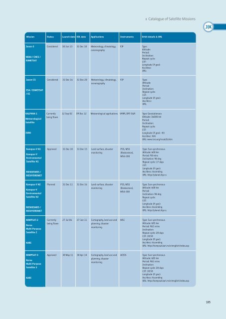
8 Catalogue of Satellite Missions<br />
J|K<br />
Mission Status Launch date EOL date Applications Instruments Orbit details & URL<br />
Jason-3<br />
NOAA / CNES /<br />
EUMETSAT<br />
Considered 30 Jun 13 31 Dec 18 Meteorology, climatology,<br />
oceanography<br />
FJP<br />
Type:<br />
Altitude:<br />
Period:<br />
Inclination:<br />
Repeat cycle:<br />
LST:<br />
Longitude (if geo):<br />
Asc/desc:<br />
URL:<br />
Jason-CS<br />
ESA / EUMETSAT<br />
/ EC<br />
Considered 31 Dec 16 31 Dec 20 Meteorology, climatology,<br />
oceanography<br />
FJP<br />
Type:<br />
Altitude:<br />
Period:<br />
Inclination:<br />
Repeat cycle:<br />
LST:<br />
Longitude (if geo):<br />
Asc/desc:<br />
URL:<br />
KALPANA-1<br />
Meteorological<br />
Satellite<br />
ISRO<br />
Currently<br />
being flown<br />
12 Sep 02 09 Dec 12 Meteorological applications VHRR, DRT-S&R<br />
Type: Geostationary<br />
Altitude: 36000 km<br />
Period:<br />
Inclination:<br />
Repeat cycle:<br />
LST:<br />
Longitude (if geo): -83<br />
Asc/desc: N/A<br />
URL: www.isro.org/insat2b.htm<br />
Kanopus-V N1<br />
Kanopus-V<br />
Environmental<br />
Satellite N1<br />
ROSKOSMOS /<br />
ROSHYDROMET<br />
Approved 31 Dec 10 31 Dec 15 Land surface, disaster<br />
monitoring<br />
PSS, MSS<br />
(Roskosmos),<br />
MSU-200<br />
Type: Sun-synchronous<br />
Altitude: 600 km<br />
Period: 98 mins<br />
Inclination: 98 deg<br />
Repeat cycle: 17 days<br />
LST:<br />
Longitude (if geo):<br />
Asc/desc: Ascending<br />
URL: http://planet.iitp.ru<br />
Kanopus-V N2<br />
Kanopus-V<br />
Environmental<br />
Satellite N2<br />
ROSKOSMOS /<br />
ROSHYDROMET<br />
Planned 31 Dec 11 31 Dec 16 Land surface, disaster<br />
monitoring<br />
PSS, MSS<br />
(Roskosmos),<br />
MSU-200<br />
Type: Sun-synchronous<br />
Altitude: 600 km<br />
Period:<br />
Inclination: 98 deg<br />
Repeat cycle:<br />
LST:<br />
Longitude (if geo):<br />
Asc/desc: Ascending<br />
URL: http://planet.iitp.ru<br />
KOMPSAT-2<br />
Korea<br />
Multi-Purpose<br />
Satellite 2<br />
KARI<br />
Currently<br />
being flown<br />
27 Jul 06 27 Jun 11 Cartography, land use and<br />
planning, disaster<br />
monitoring<br />
MSC<br />
Type: Sun-synchronous<br />
Altitude: 685 km<br />
Period: 98.5 mins<br />
Inclination:<br />
Repeat cycle: 28 days<br />
LST: 10:50<br />
Longitude (if geo):<br />
Asc/desc: Ascending<br />
URL: http://kompsat.kari.re.kr/english/index.asp<br />
KOMPSAT-3<br />
Korea<br />
Multi-Purpose<br />
Satellite 3<br />
KARI<br />
Approved 30 May 11 30 Apr 14 Cartography, land use and<br />
planning, disaster<br />
monitoring<br />
AEISS<br />
Type: Sun-synchronous<br />
Altitude: 685 km<br />
Period: 98.5 mins<br />
Inclination:<br />
Repeat cycle: 28 days<br />
LST: 10:50<br />
Longitude (if geo):<br />
Asc/desc: Ascending<br />
URL: http://kompsat.kari.re.kr/english/index.asp<br />
185


