

landbased
List of Satellite Missions (alphabetical) - ceos eo handbook
List of Satellite Missions (alphabetical) - ceos eo handbook
- No tags were found...

You also want an ePaper? Increase the reach of your titles
YUMPU automatically turns print PDFs into web optimized ePapers that Google loves.
P<br />
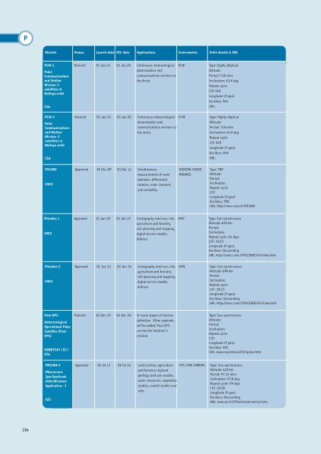
Mission Status Launch date EOL date Applications Instruments Orbit details & URL<br />
PCW-1<br />
Polar<br />
Communications<br />
and Wether<br />
Mission: 2<br />
satellites in<br />
Molinya orbit<br />
CSA<br />
PCW-2<br />
Polar<br />
Communications<br />
and Wether<br />
Mission: 2<br />
satellites in<br />
Molinya orbit<br />
CSA<br />
Planned 01 Jan 15 01 Jan 20 Continuous meteorological<br />
obseravtation and<br />
communications servioce to<br />
the Arctic<br />
Planned 01 Jan 15 01 Jan 20 Continuous meteorological<br />
obseravtation and<br />
communications servioce to<br />
the Arctic<br />
PCW<br />
PCW<br />
Type: Highly elliptical<br />
Altitude:<br />
Period: 718 mins<br />
Inclination: 63.4 deg<br />
Repeat cycle:<br />
LST: N/A<br />
Longitude (if geo):<br />
Asc/desc: N/A<br />
URL:<br />
Type: Highly elliptical<br />
Altitude:<br />
Period: 718 mins<br />
Inclination: 63.4 deg<br />
Repeat cycle:<br />
LST: N/A<br />
Longitude (if geo):<br />
Asc/desc: N/A<br />
URL:<br />
PICARD<br />
CNES<br />
Approved 01 Dec 09 01 Dec 11 Simultaneous<br />
measurements of solar<br />
diameter, differential<br />
rotation, solar constant,<br />
and variability.<br />
SODISM, SOVAP,<br />
PREMOS<br />
Type: TBD<br />
Altitude:<br />
Period:<br />
Inclination:<br />
Repeat cycle:<br />
LST:<br />
Longitude (if geo):<br />
Asc/desc: TBD<br />
URL: http://smsc.cnes.fr/PICARD<br />
Pleiades 1<br />
CNES<br />
Approved 01 Jan 10 01 Jan 15 Cartography, land use, risk,<br />
agriculture and forestry,<br />
civil planning and mapping,<br />
digital terrain models,<br />
defence<br />
HiRI<br />
Type: Sun-synchronous<br />
Altitude: 694 km<br />
Period:<br />
Inclination:<br />
Repeat cycle: 26 days<br />
LST: 10:15<br />
Longitude (if geo):<br />
Asc/desc: Descending<br />
URL: http://smsc.cnes.fr/PLEIADES/Fr/index.htm<br />
Pleiades 2<br />
CNES<br />
Approved 01 Jun 11 01 Jun 16 Cartography, land use, risk,<br />
agriculture and forestry,<br />
civil planning and mapping,<br />
digital terrain models,<br />
defense<br />
HiRI<br />
Type: Sun-synchronous<br />
Altitude: 694 km<br />
Period:<br />
Inclination:<br />
Repeat cycle:<br />
LST: 10:15<br />
Longitude (if geo):<br />
Asc/desc: Descending<br />
URL: http://smsc.cnes.fr/PLEIADES/Fr/index.htm<br />
Post-EPS<br />
Meteorological<br />
Operational Polar<br />
Satellite (Post-<br />
EPS)<br />
EUMETSAT / EC /<br />
ESA<br />
Planned 01 Dec 19 01 Dec 24 In early stages of mission<br />
definition. Other payloads<br />
will be added. Post-EPS<br />
carries the Sentinel-5<br />
mission.<br />
Type: Sun-synchronous<br />
Altitude:<br />
Period:<br />
Inclination:<br />
Repeat cycle:<br />
LST:<br />
Longitude (if geo):<br />
Asc/desc: N/A<br />
URL: www.esa.int/esaLP/LPgmes.html<br />
PRISMA-I<br />
PRecursore<br />
IperSpettrale<br />
della Missione<br />
Applicativa - I<br />
ASI<br />
Approved 30 Jul 11 30 Jul 16 Land surface, agriculture<br />
and forestry, regional<br />
geology, land use studies,<br />
water resources, vegetation<br />
studies, coastal studies and<br />
soils<br />
HYC, PAN CAMERA<br />
Type: Sun-synchronous<br />
Altitude: 620 km<br />
Period: 97.15 mins<br />
Inclination: 97.8 deg<br />
Repeat cycle: 29 days<br />
LST: 10:30<br />
Longitude (if geo):<br />
Asc/desc: Descending<br />
URL: www.asi.it/it/flash/osservare/prisma<br />
194


