

landbased
List of Satellite Missions (alphabetical) - ceos eo handbook
List of Satellite Missions (alphabetical) - ceos eo handbook
- No tags were found...

You also want an ePaper? Increase the reach of your titles
YUMPU automatically turns print PDFs into web optimized ePapers that Google loves.
K|L<br />
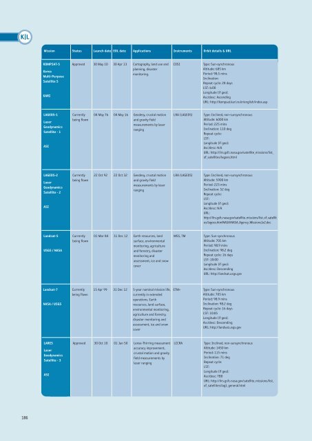
Mission Status Launch date EOL date Applications Instruments Orbit details & URL<br />
KOMPSAT-5<br />
Korea<br />
Multi-Purpose<br />
Satellite 5<br />
KARI<br />
Approved 30 May 10 30 Apr 13 Cartography, land use and<br />
planning, disaster<br />
monitoring.<br />
COSI<br />
Type: Sun-synchronous<br />
Altitude: 685 km<br />
Period: 98.5 mins<br />
Inclination:<br />
Repeat cycle: 28 days<br />
LST: 6:00<br />
Longitude (if geo):<br />
Asc/desc: Ascending<br />
URL: http://kompsat.kari.re.kr/english/index.asp<br />
LAGEOS-1<br />
Laser<br />
Geodynamics<br />
Satellite - 1<br />
ASI<br />
Currently<br />
being flown<br />
04 May 76 04 May 16 Geodesy, crustal motion<br />
and gravity field<br />
measurements by laser<br />
ranging<br />
LRA (LAGEOS)<br />
Type: Inclined, non-sunsynchronous<br />
Altitude: 6000 km<br />
Period: 225 mins<br />
Inclination: 110 deg<br />
Repeat cycle:<br />
LST:<br />
Longitude (if geo):<br />
Asc/desc: N/A<br />
URL: http://ilrs.gsfc.nasa.gov/satellite_missions/list_<br />
of_satellites/lagoes.html<br />
LAGEOS-2<br />
Laser<br />
Geodynamics<br />
Satellite - 2<br />
ASI<br />
Currently<br />
being flown<br />
22 Oct 92 22 Oct 32 Geodesy, crustal motion<br />
and gravity field<br />
measurements by laser<br />
ranging<br />
LRA (LAGEOS)<br />
Type: Inclined, non-sunsynchronous<br />
Altitude: 5900 km<br />
Period: 223 mins<br />
Inclination: 52 deg<br />
Repeat cycle:<br />
LST:<br />
Longitude (if geo):<br />
Asc/desc: N/A<br />
URL:<br />
http://ilrs.gsfc.nasa.gov/satellite_missions/list_of_satellit<br />
es/lagoes.htmlNASA\NASA_Agency_Missions1x2.doc<br />
Landsat-5<br />
USGS / NASA<br />
Currently<br />
being flown<br />
01 Mar 84 31 Dec 12 Earth resources, land<br />
surface, environmental<br />
monitoring, agriculture<br />
and forestry, disaster<br />
monitoring and<br />
assessment, ice and snow<br />
cover<br />
MSS, TM<br />
Type: Sun-synchronous<br />
Altitude: 705 km<br />
Period: 98.9 mins<br />
Inclination: 98.2 deg<br />
Repeat cycle: 16 days<br />
LST: 10:00<br />
Longitude (if geo):<br />
Asc/desc: Descending<br />
URL: http://landsat.usgs.gov<br />
Landsat-7<br />
NASA / USGS<br />
Currently<br />
being flown<br />
15 Apr 99 31 Dec 12 5-year nominal mission life,<br />
currently in extended<br />
operations. Earth<br />
resources, land surface,<br />
environmental monitoring,<br />
agriculture and forestry,<br />
disaster monitoring and<br />
assessment, ice and snow<br />
cover<br />
ETM+<br />
Type: Sun-synchronous<br />
Altitude: 705 km<br />
Period: 98.9 mins<br />
Inclination: 98.2 deg<br />
Repeat cycle: 16 days<br />
LST: 10:05<br />
Longitude (if geo):<br />
Asc/desc: Descending<br />
URL: http://landsat.usgs.gov<br />
LARES<br />
Laser<br />
Geodynamics<br />
Satellite - 3<br />
ASI<br />
Approved 30 Oct 10 01 Jan 50 Lense-Thirring measument<br />
accuracy improvement,<br />
crustal motion and gravity<br />
field measurements by<br />
laser ranging<br />
LCCRA<br />
Type: Inclined, non-sunsynchronous<br />
Altitude: 1450 km<br />
Period: 115 mins<br />
Inclination: 71 deg<br />
Repeat cycle:<br />
LST:<br />
Longitude (if geo):<br />
Asc/desc: TBD<br />
URL: http://ilrs.gsfc.nasa.gov/satellite_missions/list_<br />
of_satellites/lag1_general.html<br />
186


