

landbased
List of Satellite Missions (alphabetical) - ceos eo handbook
List of Satellite Missions (alphabetical) - ceos eo handbook
- No tags were found...

Create successful ePaper yourself
Turn your PDF publications into a flip-book with our unique Google optimized e-Paper software.
8 Catalogue of Satellite Missions<br />
S<br />
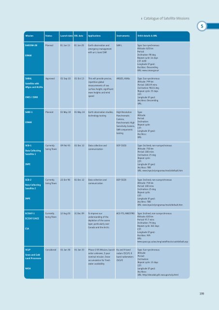
Mission Status Launch date EOL date Applications Instruments Orbit details & URL<br />
SAOCOM-2B<br />
CONAE<br />
Planned 01 Jan 15 01 Jan 20 Earth observation and<br />
emergency management<br />
with an L-band SAR<br />
SAR-L<br />
Type: Sun-synchronous<br />
Altitude: 620 km<br />
Period:<br />
Inclination: 98 deg<br />
Repeat cycle: 16 days<br />
LST: 6:00<br />
Longitude (if geo):<br />
Asc/desc: Descending<br />
URL: www.conae.gov.ar<br />
SARAL<br />
Satellite with<br />
ARgos and ALtiKa<br />
CNES / ISRO<br />
Approved 01 Sep 10 01 Oct 13 This will provide precise,<br />
repetitive global<br />
measurements of sea<br />
surface height, significant<br />
wave heights and wind<br />
speed<br />
ARGOS, AltiKa<br />
Type: Sun-synchronous<br />
Altitude: 799 km<br />
Period: 100.59 mins<br />
Inclination: 98.55 deg<br />
Repeat cycle: 35 days<br />
LST:<br />
Longitude (if geo):<br />
Asc/desc: Descending<br />
URL:<br />
SARE-1<br />
CONAE<br />
Planned 01 May 10 01 May 14 Earth observation studies,<br />
technology testing<br />
High Resolution<br />
Panchromatic<br />
Camera,<br />
Panchromatic High<br />
Sensitivity Camera,<br />
SAR components<br />
testing<br />
Type:<br />
Altitude:<br />
Period:<br />
Inclination:<br />
Repeat cycle:<br />
LST:<br />
Longitude (if geo):<br />
Asc/desc:<br />
URL:<br />
SCD-1<br />
Data Collecting<br />
Satellite 1<br />
INPE<br />
Currently<br />
being flown<br />
09 Feb 93 01 Dec 12 Data collection and<br />
communication<br />
DCP (SCD)<br />
Type: Inclined, non-sunsynchronous<br />
Altitude: 750 km<br />
Period: 100 mins<br />
Inclination: 25 deg<br />
Repeat cycle:<br />
LST:<br />
Longitude (if geo):<br />
Asc/desc: TBD<br />
URL: www.inpe.br/programas/mecb/default.htm<br />
SCD-2<br />
Data Collecting<br />
Satellite 2<br />
INPE<br />
Currently<br />
being flown<br />
22 Oct 98 01 Dec 12 Data collection and<br />
communication<br />
DCP (SCD)<br />
Type: Inclined, non-sunsynchronous<br />
Altitude: 750 km<br />
Period: 100 mins<br />
Inclination: 25 deg<br />
Repeat cycle:<br />
LST:<br />
Longitude (if geo):<br />
Asc/desc: TBD<br />
URL: www.inpe.br/programas/mecb/default.htm<br />
SCISAT-1<br />
SCISAT-I/ACE<br />
CSA<br />
Currently<br />
being flown<br />
12 Aug 03 31 Dec 09 To improve our<br />
understanding of the<br />
depletion of the ozone<br />
layer, particularly over<br />
Canada and the Arctic.<br />
ACE-FTS, MAESTRO<br />
Type: Inclined, non-sunsynchronous<br />
Altitude: 650 km<br />
Period: 97.7 mins<br />
Inclination: 74 deg<br />
Repeat cycle: 365 days<br />
LST:<br />
Longitude (if geo):<br />
Asc/desc: N/A<br />
URL:<br />
www.space.gc.ca/asc/eng/satellites/scisat/default.asp<br />
SCLP<br />
Snow and Cold<br />
Land Processes<br />
NASA<br />
Considered 01 Jan 30 01 Jan 33 Phase-2 DS Mission, launch<br />
order unknown, 3-year<br />
nominal mission. Snow<br />
accumulation for fresh<br />
water availability<br />
Ku and X-band<br />
radars (SCLP), K<br />
band radiometers<br />
(SCLP)<br />
Type: Sun-synchronous<br />
Altitude:<br />
Period:<br />
Inclination:<br />
Repeat cycle: 15 days<br />
LST:<br />
Longitude (if geo):<br />
Asc/desc:<br />
URL: http://decadal.gsfc.nasa.gov/sclp.html<br />
199


