

landbased
List of Satellite Missions (alphabetical) - ceos eo handbook
List of Satellite Missions (alphabetical) - ceos eo handbook
- No tags were found...

You also want an ePaper? Increase the reach of your titles
YUMPU automatically turns print PDFs into web optimized ePapers that Google loves.
8 Catalogue of Satellite Missions<br />
R/S<br />
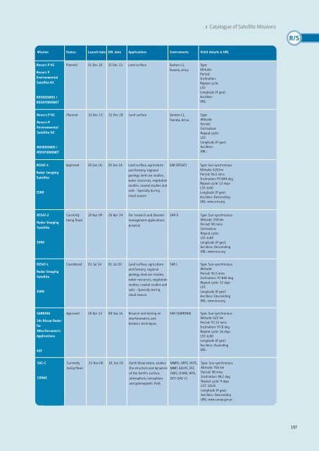
Mission Status Launch date EOL date Applications Instruments Orbit details & URL<br />
Resurs P N1<br />
Resurs P<br />
Environmental<br />
Satellite N1<br />
ROSKOSMOS /<br />
ROSHYDROMET<br />
Planned 31 Dec 10 31 Dec 15 Land surface Geoton-L1,<br />
Pamela, Arina<br />
Type:<br />
Altitude:<br />
Period:<br />
Inclination:<br />
Repeat cycle:<br />
LST:<br />
Longitude (if geo):<br />
Asc/desc:<br />
URL:<br />
Resurs P N2<br />
Resurs P<br />
Environmental<br />
Satellite N2<br />
ROSKOSMOS /<br />
ROSHYDROMET<br />
Planned 31 Dec 13 31 Dec 18 Land surface Geoton-L1,<br />
Pamela, Arina<br />
Type:<br />
Altitude:<br />
Period:<br />
Inclination:<br />
Repeat cycle:<br />
LST:<br />
Longitude (if geo):<br />
Asc/desc:<br />
URL:<br />
RISAT-1<br />
Radar Imaging<br />
Satellite<br />
ISRO<br />
Approved 20 Jan 10 20 Jan 14 Land surface, agriculture<br />
and forestry, regional<br />
geology, land use studies,<br />
water resources, vegetation<br />
studies, coastal studies and<br />
soils - Specially during<br />
cloud season<br />
SAR (RISAT)<br />
Type: Sun-synchronous<br />
Altitude: 610 km<br />
Period: 96.5 mins<br />
Inclination: 97.844 deg<br />
Repeat cycle: 12 days<br />
LST: 6:00<br />
Longitude (if geo):<br />
Asc/desc: Descending<br />
URL: www.isro.org<br />
RISAT-2<br />
Radar Imaging<br />
Satellite<br />
ISRO<br />
Currently<br />
being flown<br />
20 Apr 09 20 Apr 14 For research and disaster<br />
management applications<br />
purpose<br />
SAR-X<br />
Type: Sun-synchronous<br />
Altitude: 550 km<br />
Period: 90 mins<br />
Inclination:<br />
Repeat cycle:<br />
LST: 6:00<br />
Longitude (if geo):<br />
Asc/desc: Descending<br />
URL: www.isro.org<br />
RISAT-L<br />
Radar Imaging<br />
Satellite<br />
ISRO<br />
Considered 01 Jul 14 01 Jul 20 Land surface, agriculture<br />
and forestry, regional<br />
geology, land use studies,<br />
water resources, vegetation<br />
studies, coastal studies and<br />
soils - Specially during<br />
cloud season<br />
SAR L<br />
Type: Sun-synchronous<br />
Altitude:<br />
Period: 96.5 mins<br />
Inclination: 97.844 deg<br />
Repeat cycle: 12 days<br />
LST:<br />
Longitude (if geo):<br />
Asc/desc: Descending<br />
URL: www.isro.org<br />
SABRINA<br />
SAr Bissat Radar<br />
for<br />
INterferometric<br />
Applications<br />
ASI<br />
Approved 20 Apr 12 08 Sep 16 Resarch and testing on<br />
interferometric and<br />
bistatics techniques<br />
SAR (SABRINA)<br />
Type: Sun-synchronous<br />
Altitude: 622 km<br />
Period: 97.15 mins<br />
Inclination: 97.8 deg<br />
Repeat cycle: 16 days<br />
LST: 6:00<br />
Longitude (if geo):<br />
Asc/desc: Ascending<br />
URL:<br />
SAC-C<br />
CONAE<br />
Currently<br />
being flown<br />
21 Nov 00 01 Jan 10 Earth Observation, studies<br />
the structure and dynamics<br />
of the Earth’s surface,<br />
atmosphere, ionosphere<br />
and geomagnetic field.<br />
MMRS, HRTC, HSTC,<br />
MMP, GOLPE, IST,<br />
INES, ICARE, WTE,<br />
DCS (SAC-C)<br />
Type: Sun-synchronous<br />
Altitude: 705 km<br />
Period: 98 mins<br />
Inclination: 98.2 deg<br />
Repeat cycle: 9 days<br />
LST: 10:25<br />
Longitude (if geo):<br />
Asc/desc: Descending<br />
URL: www.conae.gov.ar<br />
197


