

landbased
List of Satellite Missions (alphabetical) - ceos eo handbook
List of Satellite Missions (alphabetical) - ceos eo handbook
- No tags were found...

You also want an ePaper? Increase the reach of your titles
YUMPU automatically turns print PDFs into web optimized ePapers that Google loves.
I|J<br />
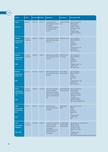
Mission Status Launch date EOL date Applications Instruments Orbit details & URL<br />
Ingenio<br />
CDTI / ESA<br />
Approved 31 Dec 12 31 Dec 19 Cartography, land use,<br />
urban management, water<br />
management,<br />
environmental monitoring,<br />
risk management and<br />
security.<br />
PAN+MS (RGB+NIR),<br />
UVAS<br />
Type: Sun-synchronous<br />
Altitude: 668 km<br />
Period: 98 mins<br />
Inclination: 98 deg<br />
Repeat cycle: 43 days<br />
LST: 10:30<br />
Longitude (if geo):<br />
Asc/desc: Descending<br />
URL:<br />
INSAT-2E<br />
Indian National<br />
Satellite - 2E<br />
ISRO<br />
Currently<br />
being flown<br />
03 Apr 99 04 Mar 11 Meteorology, data collection<br />
and communication, search<br />
and rescue<br />
VHRR, CCD camera<br />
Type: Geostationary<br />
Altitude: 36000 km<br />
Period:<br />
Inclination:<br />
Repeat cycle:<br />
LST:<br />
Longitude (if geo): -83<br />
Asc/desc: N/A<br />
URL: www.isro.org<br />
INSAT-3A<br />
Indian National<br />
Satellite - 3A<br />
ISRO<br />
Currently<br />
being flown<br />
04 Apr 03 10 Apr 13 Meteorology, data collection<br />
and communication, search<br />
and rescue<br />
VHRR, DRT-S&R,<br />
CCD camera<br />
Type: Geostationary<br />
Altitude: 36000 km<br />
Period:<br />
Inclination:<br />
Repeat cycle:<br />
LST:<br />
Longitude (if geo): -94<br />
Asc/desc: N/A<br />
URL: www.isro.org<br />
INSAT-3D<br />
Indian National<br />
Satellite - 3D<br />
ISRO<br />
Approved 01 Jun 10 01 Jul 17 Meteorology, data collection<br />
and communication, search<br />
and rescue<br />
Imager (INSAT),<br />
Sounder (INSAT)<br />
Type: Geostationary<br />
Altitude: 36000 km<br />
Period:<br />
Inclination:<br />
Repeat cycle:<br />
LST:<br />
Longitude (if geo): -93.5<br />
Asc/desc: N/A<br />
URL: www.isro.org<br />
IRS-1D<br />
Indian Remote<br />
Sensing Satellite<br />
- 1D<br />
ISRO<br />
Currently<br />
being flown<br />
29 Sep 97 31 Dec 09 Land surface, agriculture<br />
and forestry regional<br />
geology, land use studies,<br />
water resources, vegetation<br />
studies, coastal studies and<br />
soils<br />
LISS-III (IRS), PAN<br />
(IRS-1C/1D), WiFS<br />
Type: Sun-synchronous<br />
Altitude: 817 km<br />
Period: 101 mins<br />
Inclination: 98.6 deg<br />
Repeat cycle: 24 days<br />
LST: 10:30<br />
Longitude (if geo):<br />
Asc/desc: Descending<br />
URL: www.isro.org/insat2b.htm<br />
ISTAG<br />
Indian Satellite<br />
for Aerosol and<br />
Gases<br />
ISRO<br />
Planned 01 Jan 11 01 Jan 15 Study of changes in<br />
atmospheric aerosol and<br />
trace gases<br />
MAPI, MAVELI,<br />
MAGIS<br />
Type: Sun-synchronous<br />
Altitude:<br />
Period:<br />
Inclination:<br />
Repeat cycle:<br />
LST:<br />
Longitude (if geo):<br />
Asc/desc: TBD<br />
URL:<br />
Jason<br />
Ocean surface<br />
topography<br />
NASA / CNES<br />
Currently<br />
being flown<br />
07 Dec 01 30 Set 11 3-year nominal mission life,<br />
currently in extended<br />
operations. Physical<br />
oceanography,<br />
geodesy/gravity, climate<br />
monitoring, marine<br />
meteorology<br />
LRA, JMR, DORIS-<br />
NG, POSEIDON-2<br />
(SSALT-2), TRSR<br />
Type: Inclined, non-sunsynchronous<br />
Altitude: 1336 km<br />
Period: 112.4 mins<br />
Inclination: 66 deg<br />
Repeat cycle: 10 days<br />
LST:<br />
Longitude (if geo):<br />
Asc/desc: N/A<br />
URL: http://sealevel.jpl.nasa.gov/mission/jason-1.html<br />
184


