

landbased
List of Satellite Missions (alphabetical) - ceos eo handbook
List of Satellite Missions (alphabetical) - ceos eo handbook
- No tags were found...

You also want an ePaper? Increase the reach of your titles
YUMPU automatically turns print PDFs into web optimized ePapers that Google loves.
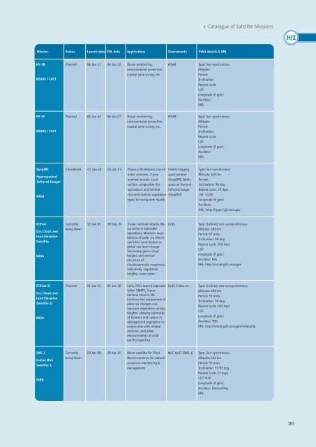
8 Catalogue of Satellite Missions<br />
H|I<br />
Mission Status Launch date EOL date Applications Instruments Orbit details & URL<br />
HY-3B<br />
NSOAS / CAST<br />
Planned 06 Jan 17 06 Jan 22 Ocean monitoring,<br />
environmental protection,<br />
coastal zone survey, etc.<br />
WSAR<br />
Type: Sun-synchronous<br />
Altitude:<br />
Period:<br />
Inclination:<br />
Repeat cycle:<br />
LST:<br />
Longitude (if geo):<br />
Asc/desc:<br />
URL:<br />
HY-3C<br />
NSOAS / CAST<br />
Planned 06 Jan 22 06 Jan 27 Ocean monitoring,<br />
environmental protection,<br />
coastal zone survey, etc.<br />
WSAR<br />
Type: Sun-synchronous<br />
Altitude:<br />
Period:<br />
Inclination:<br />
Repeat cycle:<br />
LST:<br />
Longitude (if geo):<br />
Asc/desc:<br />
URL:<br />
HyspIRI<br />
Hyperspectral<br />
Infrared Imager<br />
NASA<br />
Considered 01 Jan 20 01 Jan 23 Phase-2 DS Mission, launch<br />
order unknown, 3-year<br />
nominal mission. Land<br />
surface composition for<br />
agriculture and mineral<br />
Visible imaging<br />
spectrometer<br />
(HyspIRI), Multispectral<br />
thermal<br />
infrared imager<br />
characterization; vegetation (HyspIRI)<br />
types for ecosystem health<br />
Type: Sun-synchronous<br />
Altitude: 626 km<br />
Period:<br />
Inclination: 98 deg<br />
Repeat cycle: 19 days<br />
LST: 11:00<br />
Longitude (if geo):<br />
Asc/desc:<br />
URL: http://hyspiri.jpl.nasa.gov<br />
ICESat<br />
Ice, Cloud, and<br />
Land Elevation<br />
Satellite<br />
NASA<br />
Currently<br />
being flown<br />
12 Jan 03 30 Sep 10 3-year nominal mission life,<br />
currently in extended<br />
operations. Monitors mass<br />
balance of polar ice sheets<br />
and their contribution to<br />
global sea level change.<br />
Secondary goals: cloud<br />
heights and vertical<br />
structure of<br />
clouds/aerosols; roughness,<br />
reflectivity, vegetation<br />
heights, snow-cover.<br />
GLAS<br />
Type: Inclined, non-sunsynchronous<br />
Altitude: 600 km<br />
Period: 97 mins<br />
Inclination: 94 deg<br />
Repeat cycle: 183 days<br />
LST:<br />
Longitude (if geo):<br />
Asc/desc: N/A<br />
URL: http://icesat.gsfc.nasa.gov<br />
ICESat-II<br />
Ice, Cloud, and<br />
Land Elevation<br />
Satellite II<br />
NASA<br />
Planned 01 Jan 15 01 Jan 18 Early 2015 launch expected<br />
(after SMAP), 3-year<br />
nominal mission life.<br />
Continue the assessment of<br />
polar ice changes and<br />
measure vegetation canopy<br />
heights, allowing estimates<br />
of biomass and carbon in<br />
aboveground vegetation in<br />
conjunction with related<br />
missions, and allow<br />
measurements of solid<br />
earth properties.<br />
GLAS Follow-on<br />
Type: Inclined, non-sunsynchronous<br />
Altitude: 600 km<br />
Period: 97 mins<br />
Inclination: 94 deg<br />
Repeat cycle: 183 days<br />
LST:<br />
Longitude (if geo):<br />
Asc/desc: TBD<br />
URL: http://icesat.gsfc.nasa.gov/index.php<br />
IMS-1<br />
Indian Mini<br />
Satellite-1<br />
ISRO<br />
Currently<br />
being flown<br />
28 Apr 08 28 Apr 10 Micro-satellite for Third<br />
World countries for natural<br />
resources monitoring &<br />
management<br />
MxT, HySI (IMS-1)<br />
Type: Sun-synchronous<br />
Altitude: 632 km<br />
Period: 97 mins<br />
Inclination: 97.92 deg<br />
Repeat cycle: 22 days<br />
LST: 9:30<br />
Longitude (if geo):<br />
Asc/desc: Descending<br />
URL:<br />
183


