

landbased
List of Satellite Missions (alphabetical) - ceos eo handbook
List of Satellite Missions (alphabetical) - ceos eo handbook
- No tags were found...

You also want an ePaper? Increase the reach of your titles
YUMPU automatically turns print PDFs into web optimized ePapers that Google loves.
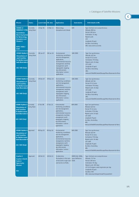
8 Catalogue of Satellite Missions<br />
C<br />
Mission Status Launch date EOL date Applications Instruments Orbit details & URL<br />
COSMIC-6/<br />
FORMOSAT-3 FM6<br />
Constellation<br />
Observing System<br />
for Meteorology,<br />
Ionosphere and<br />
Climate-6<br />
NSPO / NOAA /<br />
UCAR<br />
Currently<br />
being flown<br />
14 Apr 06 15 Mar 11 Meteorology,<br />
Ionosphere and climate<br />
GOX<br />
Type: Inclined, non-sunsynchronous<br />
Altitude: 800 km<br />
Period: 100 mins<br />
Inclination: 72 deg<br />
Repeat cycle:<br />
LST:<br />
Longitude (if geo):<br />
Asc/desc: Ascending<br />
URL: www.cosmic.ucar.edu<br />
COSMO-SkyMed 1 Currently<br />
COnstellation of being flown<br />
small Satellites<br />
for Mediterranean<br />
basin Observation 1<br />
ASI / MiD (Italy)<br />
COSMO-SkyMed 2 Currently<br />
COnstellation of being flown<br />
small Satellites<br />
for Mediterranean<br />
basin Observation 2<br />
ASI / MiD (Italy)<br />
COSMO-SkyMed 3 Currently<br />
COnstellation of being flown<br />
small Satellites<br />
for Mediterranean<br />
basin Observation 3<br />
ASI / MiD (Italy)<br />
08 Jun 07 08 Jun 14 Environmental<br />
monitoring, surveillance<br />
and risk management<br />
applications,<br />
environmental resources<br />
management, maritime<br />
management, earth<br />
topographic mapping,<br />
law enforcement,<br />
informative / science<br />
applications<br />
SAR 2000<br />
09 Dec 07 09 Dec 14 Environmental<br />
monitoring, surveillance<br />
and risk management<br />
applications,<br />
environmental resources<br />
management, maritime<br />
management, earth<br />
topographic mapping,<br />
law enforcement,<br />
informative / science<br />
applications<br />
SAR 2000<br />
27 Oct 08 27 Oct 15 Environmental<br />
monitoring, surveillance<br />
and risk management<br />
applications,<br />
environmental resources<br />
management, maritime<br />
management, earth<br />
topographic mapping,<br />
law enforcement,<br />
informative / science<br />
applications<br />
SAR 2000<br />
Type: Sun-synchronous<br />
Altitude: 622 km<br />
Period: 97.15 mins<br />
Inclination: 97.8 deg<br />
Repeat cycle: 16 days<br />
LST: 6:00<br />
Longitude (if geo):<br />
Asc/desc: Ascending<br />
URL:<br />
www.asi.it/SiteEN/ContentSite.aspx?Area=Osservare+la+Terra<br />
Type: Sun-synchronous<br />
Altitude: 622 km<br />
Period: 97.15 mins<br />
Inclination: 97.8 deg<br />
Repeat cycle: 16 days<br />
LST: 6:00<br />
Longitude (if geo):<br />
Asc/desc: Ascending<br />
URL:<br />
www.asi.it/SiteEN/ContentSite.aspx?Area=Osservare+la+Terra<br />
Type: Sun-synchronous<br />
Altitude: 622 km<br />
Period: 97.15 mins<br />
Inclination: 97.8 deg<br />
Repeat cycle: 16 days<br />
LST: 6:00<br />
Longitude (if geo):<br />
Asc/desc: Ascending<br />
URL:<br />
www.asi.it/SiteEN/ContentSite.aspx?Area=Osservare+la+Terra<br />
COSMO-SkyMed 4<br />
COnstellation of<br />
small Satellites<br />
for Mediterranean<br />
basin Observation 4<br />
ASI / MiD (Italy)<br />
Approved 08 Sep 10 08 Sep 16 Environmental<br />
monitoring, surveillance<br />
and risk management<br />
applications,<br />
environmental resources<br />
management, maritime<br />
management, earth<br />
topographic mapping,<br />
law enforcement,<br />
informative / science<br />
applications<br />
SAR 2000<br />
Type: Sun-synchronous<br />
Altitude: 622 km<br />
Period: 97.15 mins<br />
Inclination: 97.8 deg<br />
Repeat cycle: 16 days<br />
LST: 6:00<br />
Longitude (if geo):<br />
Asc/desc: Ascending<br />
URL:<br />
www.asi.it/SiteEN/ContentSite.aspx?Area=Osservare+la+Terra<br />
CryoSat-2<br />
CryoSat-2 (Earth<br />
Explorer<br />
Opportunity<br />
Mission)<br />
ESA<br />
Approved 28 Feb 10 28 Feb 13 To determine<br />
fluctuations in the mass<br />
of the Earth’s major land<br />
and marine ice fields.<br />
DORIS-NG, SIRAL,<br />
Laser Reflectors<br />
(ESA)<br />
Type: Inclined, non-sunsynchronous<br />
Altitude: 717 km<br />
Period: 100 mins<br />
Inclination: 92 deg<br />
Repeat cycle: 369 days<br />
LST: 0.25 degree nodal regression per day<br />
Longitude (if geo):<br />
Asc/desc: N/A<br />
URL: www.esa.int/export/esaLP/cryosat.html<br />
171


