

landbased
List of Satellite Missions (alphabetical) - ceos eo handbook
List of Satellite Missions (alphabetical) - ceos eo handbook
- No tags were found...

Create successful ePaper yourself
Turn your PDF publications into a flip-book with our unique Google optimized e-Paper software.
8 Catalogue of Satellite Missions<br />
S|T<br />
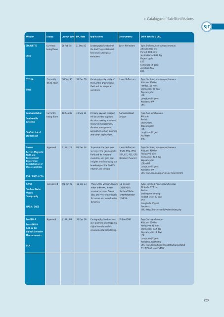
Mission Status Launch date EOL date Applications Instruments Orbit details & URL<br />
STARLETTE<br />
CNES<br />
Currently<br />
being flown<br />
06 Feb 75 31 Dec 50 Geodesy/gravity study of<br />
the Earth’s gravitational<br />
field and its temporal<br />
variations<br />
Laser Reflectors<br />
Type: Inclined, non-sunsynchronous<br />
Altitude: 812 km<br />
Period: 104 mins<br />
Inclination: 49.83 deg<br />
Repeat cycle:<br />
LST:<br />
Longitude (if geo):<br />
Asc/desc: N/A<br />
URL:<br />
STELLA<br />
CNES<br />
Currently<br />
being flown<br />
30 Sep 93 31 Dec 50 Geodesy/gravity study of<br />
the Earth’s gravitational<br />
field and its temporal<br />
variations<br />
Laser Reflectors<br />
Type: Inclined, non-sunsynchronous<br />
Altitude: 830 km<br />
Period: 101 mins<br />
Inclination: 98 deg<br />
Repeat cycle:<br />
LST:<br />
Longitude (if geo):<br />
Asc/desc: N/A<br />
URL:<br />
SumbandilaSat<br />
Sumbandila<br />
Satellite<br />
SANSA / Uni of<br />
Stellenbosh<br />
Currently<br />
being flown<br />
18 Sep 09 18 Sep 14 Primary payload (imager)<br />
will be used to support<br />
decision making in natural<br />
resource management,<br />
disaster management,<br />
agriculture, urban planning<br />
and other applications.<br />
SumbandilaSat<br />
Imager<br />
Type: Sun-synchronous<br />
Altitude:<br />
Period:<br />
Inclination:<br />
Repeat cycle:<br />
LST:<br />
Longitude (if geo):<br />
Asc/desc:<br />
URL:<br />
Swarm<br />
Earth's Magnetic<br />
Field and<br />
Environment<br />
Exploreres;<br />
Constellation of<br />
three satellites<br />
ESA / CNES / CSA<br />
SWOT<br />
Surface Water<br />
Ocean<br />
Topography<br />
NASA / CNES<br />
Approved 01 Oct 10 01 Dec 14 To provide the best ever<br />
survey of the geomagnetic<br />
field and its temporal<br />
evolution, and gain new<br />
insights into improving our<br />
knowledge of the Earth’s<br />
interior and climate.<br />
Considered 01 Jan 20 01 Jan 23 Phase-2 DS Mission, launch<br />
order unknown, 3-year<br />
nominal mission. Ocean,<br />
lake, and river water levels<br />
for ocean and inland water<br />
dynamics<br />
Laser Reflectors<br />
(ESA), ASM, VFM,<br />
STR, EFI, ACC, GPS<br />
Receiver (Swarm)<br />
CO Sensor<br />
(ASCENDS),<br />
Ka-band Radar<br />
INterferometer<br />
(KaRIN)<br />
Type: Inclined, non-sunsynchronous<br />
Altitude: 450 km<br />
Period: 90 mins<br />
Inclination: 87.4 deg<br />
Repeat cycle:<br />
LST: 6:00<br />
Longitude (if geo):<br />
Asc/desc: N/A<br />
URL: www.esa.int/export/esaLP/swarm.html<br />
Type: Inclined, non-sunsynchronous<br />
Altitude: 970 km<br />
Period:<br />
Inclination: 78 deg<br />
Repeat cycle: 22 days<br />
LST:<br />
Longitude (if geo):<br />
Asc/desc:<br />
URL: http://bprc.osu.edu/water/index.php<br />
TanDEM-X<br />
TerraSAR-X<br />
Add-on for<br />
Digital Elevation<br />
Measurements<br />
DLR<br />
Approved 21 Oct 09 31 Dec 14 Cartography, land surface,<br />
civil planning and mapping,<br />
digital terrain models,<br />
environmental monitoring.<br />
X-Band SAR<br />
Type: Sun-synchronous<br />
Altitude: 514 km<br />
Period: 94.85 mins<br />
Inclination: 97.4 deg<br />
Repeat cycle: 11 days<br />
LST:<br />
Longitude (if geo):<br />
Asc/desc: Ascending<br />
URL: www.dlr.de/hr/desktopdefault.aspx/tabid-<br />
2317/3669_read-5488/<br />
203


