

landbased
List of Satellite Missions (alphabetical) - ceos eo handbook
List of Satellite Missions (alphabetical) - ceos eo handbook
- No tags were found...

Create successful ePaper yourself
Turn your PDF publications into a flip-book with our unique Google optimized e-Paper software.
C/D<br />
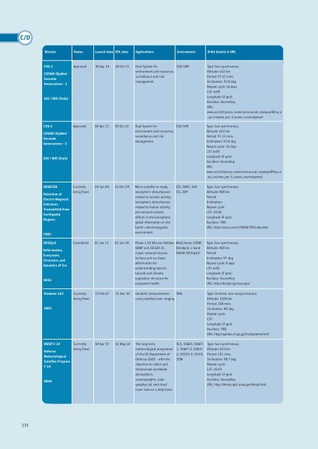
Mission Status Launch date EOL date Applications Instruments Orbit details & URL<br />
CSG-1<br />
COSMO-SkyMed<br />
Seconda<br />
Generazione - 1<br />
ASI / MiD (Italy)<br />
CSG-2<br />
COSMO-SkyMed<br />
Seconda<br />
Generazione - 2<br />
ASI / MiD (Italy)<br />
Approved 30 Apr 14 30 Oct 21 Dual System for<br />
environment and resources,<br />
surveillance and risk<br />
management<br />
CSG-SAR<br />
Approved 30 Apr 15 30 Oct 22 Dual System for<br />
environment and resources,<br />
surveillance and risk<br />
management<br />
CSG-SAR<br />
Type: Sun-synchronous<br />
Altitude: 622 km<br />
Period: 97.15 mins<br />
Inclination: 97.8 deg<br />
Repeat cycle: 16 days<br />
LST: 6:00<br />
Longitude (if geo):<br />
Asc/desc: Ascending<br />
URL:<br />
www.asi.it/it/press_room/comunucati_stampa/difesa_e<br />
_asi_insieme_per_il_nuovo_cosmoskymed<br />
DEMETER<br />
Detection of<br />
Electro-Magnetic<br />
Emissions<br />
Transmitted from<br />
Earthquake<br />
Regions<br />
CNES<br />
Currently<br />
being flown<br />
24 Jun 04 31 Dec 09 Micro-satellite to study;<br />
ionospheric disturbances<br />
related to seismic activity,<br />
ionospheric disturbances<br />
related to human activity,<br />
pre and post-seismic<br />
effects in the ionosphere,<br />
global information on the<br />
Earth's electromagnetic<br />
environment<br />
ICE, IMSC, IAP,<br />
ISL, IDP<br />
Type: Sun-synchronous<br />
Altitude: 800 km<br />
Period:<br />
Inclination:<br />
Repeat cycle:<br />
LST: 10:30<br />
Longitude (if geo):<br />
Asc/desc: TBD<br />
URL: http://smsc.cnes.fr/DEMETER/index.htm<br />
DESDynI<br />
Deformation,<br />
Ecosystem,<br />
Structure, and<br />
Dynamics of Ice<br />
NASA<br />
Considered 01 Jan 17 01 Jan 20 Phase-1 DS Mission (follows<br />
SMAP and ICESAT-2),<br />
3-year nominal mission.<br />
Surface and ice sheet<br />
deformation for<br />
understanding natural<br />
hazards and climate;<br />
vegetation structure for<br />
ecosystem health<br />
Multi-beam LIDAR<br />
(Desdyni), L-band<br />
INSAR (DESdynI)<br />
Type: Sun-synchronous<br />
Altitude: 400 km<br />
Period:<br />
Inclination: 97 deg<br />
Repeat cycle: 8 days<br />
LST: 6:00<br />
Longitude (if geo):<br />
Asc/desc: Ascending<br />
URL: http://desdyni.jpl.nasa.gov<br />
Diademe 1&2<br />
CNES<br />
Currently<br />
being flown<br />
15 Feb 67 31 Dec 50 Geodetic measurements RRA<br />
using satellite laser ranging<br />
Type: Inclined, non-sunsynchronous<br />
Altitude: 1200 km<br />
Period: 108 mins<br />
Inclination: 40 deg<br />
Repeat cycle:<br />
LST:<br />
Longitude (if geo):<br />
Asc/desc: TBD<br />
URL: http://galileo.crl.go.jp/ilrs/diademe.html<br />
DMSP F-14<br />
Defense<br />
Meteorological<br />
Satellite Program<br />
F-14<br />
NOAA<br />
Currently<br />
being flown<br />
04 Apr 97 01 May 10 The long-term<br />
meteorological programme<br />
of the US Department of<br />
Defense (DoD) - with the<br />
objective to collect and<br />
disseminate worldwide<br />
atmospheric,<br />
oceanographic, solargeophyscial,<br />
and cloud<br />
cover data on a daily basis.<br />
OLS, SSM/I, SSM/T-<br />
1, SSM/T-2, SSB/X-<br />
2, SSI/ES-2, SSJ/4,<br />
SSM<br />
Type: Sun-synchronous<br />
Altitude: 833 km<br />
Period: 101 mins<br />
Inclination: 98.7 deg<br />
Repeat cycle:<br />
LST: 20:29<br />
Longitude (if geo):<br />
Asc/desc: Ascending<br />
URL: http://dmsp.ngdc.noaa.gov/dmsp.html<br />
172


