

landbased
List of Satellite Missions (alphabetical) - ceos eo handbook
List of Satellite Missions (alphabetical) - ceos eo handbook
- No tags were found...

Create successful ePaper yourself
Turn your PDF publications into a flip-book with our unique Google optimized e-Paper software.
8 Catalogue of Satellite Missions<br />
G<br />
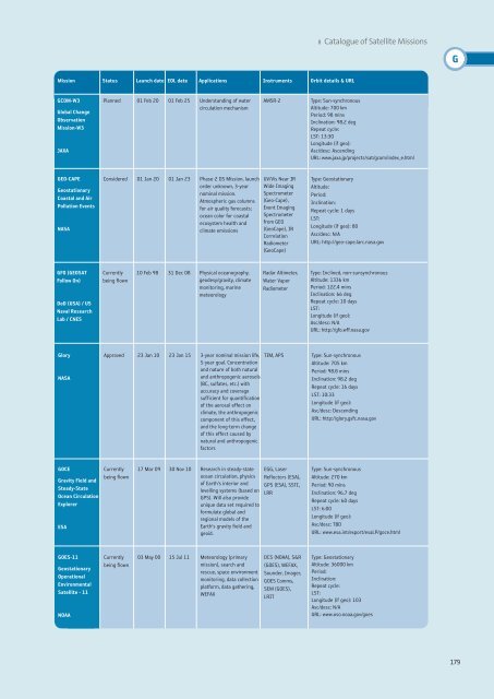
Mission Status Launch date EOL date Applications Instruments Orbit details & URL<br />
GCOM-W3<br />
Global Change<br />
Observation<br />
Mission-W3<br />
JAXA<br />
Planned 01 Feb 20 01 Feb 25 Understanding of water<br />
circulation mechanism<br />
AMSR-2<br />
Type: Sun-synchronous<br />
Altitude: 700 km<br />
Period: 98 mins<br />
Inclination: 98.2 deg<br />
Repeat cycle:<br />
LST: 13:30<br />
Longitude (if geo):<br />
Asc/desc: Ascending<br />
URL: www.jaxa.jp/projects/sat/gcom/index_e.html<br />
GEO-CAPE<br />
Geostationary<br />
Coastal and Air<br />
Pollution Events<br />
NASA<br />
Considered 01 Jan 20 01 Jan 23 Phase-2 DS Mission, launch<br />
order unknown, 3-year<br />
nominal mission.<br />
Atmospheric gas columns<br />
for air quality forecasts;<br />
ocean color for coastal<br />
ecosystem health and<br />
climate emissions<br />
UV/Vis Near IR<br />
Wide Imaging<br />
Spectrometer<br />
(Geo-Cape),<br />
Event Imaging<br />
Spectrometer<br />
from GEO<br />
(GeoCape), IR<br />
Correlation<br />
Radiometer<br />
(GeoCape)<br />
Type: Geostationary<br />
Altitude:<br />
Period:<br />
Inclination:<br />
Repeat cycle: 1 days<br />
LST:<br />
Longitude (if geo): 80<br />
Asc/desc: N/A<br />
URL: http://geo-cape.larc.nasa.gov<br />
GFO (GEOSAT<br />
Follow On)<br />
DoD (USA) / US<br />
Naval Research<br />
Lab / CNES<br />
Currently<br />
being flown<br />
10 Feb 98 31 Dec 08 Physical oceanography,<br />
geodesy/gravity, climate<br />
monitoring, marine<br />
meteorology<br />
Radar Altimeter,<br />
Water Vapor<br />
Radiometer<br />
Type: Inclined, non-sunsynchronous<br />
Altitude: 1336 km<br />
Period: 122.4 mins<br />
Inclination: 66 deg<br />
Repeat cycle: 10 days<br />
LST:<br />
Longitude (if geo):<br />
Asc/desc: N/A<br />
URL: http://gfo.wff.nasa.gov<br />
Glory<br />
NASA<br />
Approved 23 Jan 10 23 Jan 15 3-year nominal mission life,<br />
5-year goal. Concentration<br />
and nature of both natural<br />
and anthropogenic aerosols<br />
(BC, sulfates, etc.) with<br />
accuracy and coverage<br />
sufficient for quantification<br />
of the aerosol effect on<br />
climate, the anthropogenic<br />
component of this effect,<br />
and the long-term change<br />
of this effect caused by<br />
natural and anthropogenic<br />
factors<br />
TIM, APS<br />
Type: Sun-synchronous<br />
Altitude: 705 km<br />
Period: 98.8 mins<br />
Inclination: 98.2 deg<br />
Repeat cycle: 16 days<br />
LST: 10:33<br />
Longitude (if geo):<br />
Asc/desc: Descending<br />
URL: http://glory.gsfc.nasa.gov<br />
GOCE<br />
Gravity Field and<br />
Steady-State<br />
Ocean Circulation<br />
Explorer<br />
ESA<br />
Currently<br />
being flown<br />
17 Mar 09 30 Nov 10 Research in steady-state<br />
ocean circulation, physics<br />
of Earth's interior and<br />
levelling systems (based on<br />
GPS). Will also provide<br />
unique data set required to<br />
formulate global and<br />
regional models of the<br />
Earth's gravity field and<br />
geoid.<br />
EGG, Laser<br />
Reflectors (ESA),<br />
GPS (ESA), SSTI,<br />
LRR<br />
Type: Sun-synchronous<br />
Altitude: 270 km<br />
Period: 90 mins<br />
Inclination: 96.7 deg<br />
Repeat cycle: 60 days<br />
LST: 6:00<br />
Longitude (if geo):<br />
Asc/desc: TBD<br />
URL: www.esa.int/export/esaLP/goce.html<br />
GOES-11<br />
Geostationary<br />
Operational<br />
Environmental<br />
Satellite - 11<br />
NOAA<br />
Currently<br />
being flown<br />
03 May 00 15 Jul 11 Meteorology (primary<br />
mission), search and<br />
rescue, space environment<br />
monitoring, data collection<br />
platform, data gathering,<br />
WEFAX<br />
DCS (NOAA), S&R<br />
(GOES), WEFAX,<br />
Sounder, Imager,<br />
GOES Comms,<br />
SEM (GOES),<br />
LRIT<br />
Type: Geostationary<br />
Altitude: 36000 km<br />
Period:<br />
Inclination:<br />
Repeat cycle:<br />
LST:<br />
Longitude (if geo): 103<br />
Asc/desc: N/A<br />
URL: www.oso.noaa.gov/goes<br />
179


