

landbased
List of Satellite Missions (alphabetical) - ceos eo handbook
List of Satellite Missions (alphabetical) - ceos eo handbook
- No tags were found...

Create successful ePaper yourself
Turn your PDF publications into a flip-book with our unique Google optimized e-Paper software.
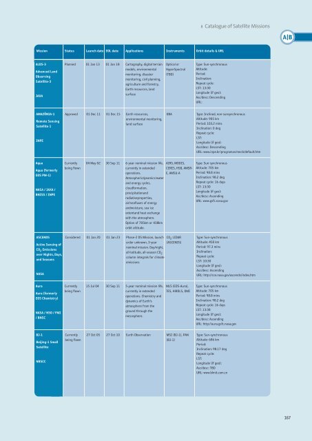
8 Catalogue of Satellite Missions<br />
A|B<br />
Mission Status Launch date EOL date Applications Instruments Orbit details & URL<br />
ALOS-3<br />
Advanced Land<br />
Observing<br />
Satellite-3<br />
JAXA<br />
Planned 01 Jan 13 01 Jan 18 Cartography, digital terrain<br />
models, environmental<br />
monitoring, disaster<br />
monitoring, civil planning,<br />
agriculture and forestry,<br />
Earth resources, land<br />
surface<br />
Optical or<br />
HyperSpectral<br />
(TBD)<br />
Type: Sun-synchronous<br />
Altitude:<br />
Period:<br />
Inclination:<br />
Repeat cycle:<br />
LST: 13:30<br />
Longitude (if geo):<br />
Asc/desc: Descending<br />
URL:<br />
AMAZÔNIA-1<br />
Remote Sensing<br />
Satellite 1<br />
INPE<br />
Approved 01 Dec 11 01 Dec 15 Earth resources,<br />
environmental monitoring,<br />
land surface<br />
OBA<br />
Type: Inclined, non-sunsynchronous<br />
Altitude: 905 km<br />
Period: 103.2 mins<br />
Inclination: 0 deg<br />
Repeat cycle:<br />
LST:<br />
Longitude (if geo):<br />
Asc/desc: Descending<br />
URL: www.inpe.br/programas/mecb/default.htm<br />
Aqua<br />
Aqua (formerly<br />
EOS PM-1)<br />
NASA / JAXA /<br />
BNISS / INPE<br />
Currently<br />
being flown<br />
04 May 02 30 Sep 11 6-year nominal mission life,<br />
currently in extended<br />
operations.<br />
Atmosphericdynamics/water<br />
and energy cycles,<br />
cloudformation,<br />
precipitationand<br />
radiativeproperties,<br />
air/seafluxes of energy<br />
andmoisture, sea ice<br />
extentand heat exchange<br />
with the atmosphere.<br />
Option of 705km or 438km<br />
orbit altitude.<br />
AIRS, MODIS,<br />
CERES, HSB, AMSR-<br />
E, AMSU-A<br />
Type: Sun-synchronous<br />
Altitude: 705 km<br />
Period: 98.8 mins<br />
Inclination: 98.2 deg<br />
Repeat cycle: 16 days<br />
LST: 13:30<br />
Longitude (if geo):<br />
Asc/desc: Ascending<br />
URL: www.gsfc.nasa.gov<br />
ASCENDS<br />
Active Sensing of<br />
CO 2 Emissions<br />
over Nights, Days,<br />
and Seasons<br />
NASA<br />
Considered 01 Jan 20 01 Jan 23 Phase-2 DS Mission, launch<br />
order unknown, 3-year<br />
nominal mission. Day/night,<br />
all-latitude, all-season CO 2<br />
column integrals for climate<br />
emissions<br />
CO 2 LIDAR<br />
(ASCENDS)<br />
Type: Sun-synchronous<br />
Altitude: 450 km<br />
Period: 97.3 mins<br />
Inclination:<br />
Repeat cycle:<br />
LST: 10:30<br />
Longitude (if geo):<br />
Asc/desc: Ascending<br />
URL: http://cce.nasa.gov/ascends/index.htm<br />
Aura<br />
Aura (formerly<br />
EOS Chemistry)<br />
NASA / NSO / FMI<br />
/ BNSC<br />
Currently<br />
being flown<br />
15 Jul 04 30 Sep 11 5-year nominal mission life,<br />
currently in extended<br />
operations. Chemistry and<br />
dynamics of Earth’s<br />
atmosphere from the<br />
ground through the<br />
mesosphere.<br />
MLS (EOS-Aura),<br />
TES, HiRDLS, OMI<br />
Type: Sun-synchronous<br />
Altitude: 705 km<br />
Period: 98.8 mins<br />
Inclination: 98.2 deg<br />
Repeat cycle: 16 days<br />
LST: 13:38<br />
Longitude (if geo):<br />
Asc/desc: Ascending<br />
URL: http://aura.gsfc.nasa.gov<br />
BJ-1<br />
Beijing-1 Small<br />
Satellite<br />
NRSCC<br />
Currently<br />
being flown<br />
27 Oct 05 27 Oct 10 Earth Observation MSI (BJ-1), PAN<br />
(BJ-1)<br />
Type: Sun-synchronous<br />
Altitude: 686 km<br />
Period:<br />
Inclination: 98.17 deg<br />
Repeat cycle:<br />
LST:<br />
Longitude (if geo):<br />
Asc/desc: TBD<br />
URL: www.blmit.com.cn<br />
167


