

landbased
List of Satellite Missions (alphabetical) - ceos eo handbook
List of Satellite Missions (alphabetical) - ceos eo handbook
- No tags were found...

Create successful ePaper yourself
Turn your PDF publications into a flip-book with our unique Google optimized e-Paper software.
R<br />
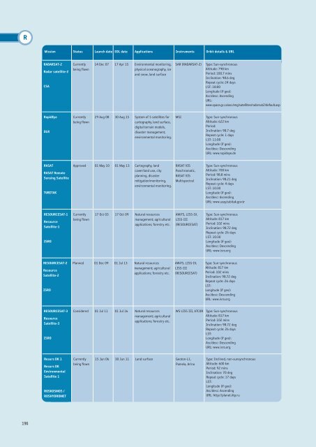
Mission Status Launch date EOL date Applications Instruments Orbit details & URL<br />
RADARSAT-2<br />
Radar satellite-2<br />
CSA<br />
Currently<br />
being flown<br />
14 Dec 07 17 Apr 15 Environmental monitoring,<br />
physical oceanography, ice<br />
and snow, land surface<br />
SAR (RADARSAT-2)<br />
Type: Sun-synchronous<br />
Altitude: 798 km<br />
Period: 100.7 mins<br />
Inclination: 98.6 deg<br />
Repeat cycle: 24 days<br />
LST: 18:00<br />
Longitude (if geo):<br />
Asc/desc: Ascending<br />
URL:<br />
www.space.gc.ca/asc/eng/satellites/radarsat2/default.asp<br />
RapidEye<br />
DLR<br />
Currently<br />
being flown<br />
29 Aug 08 30 Aug 15 System of 5 satellites for<br />
cartography, land surface,<br />
digital terrain models,<br />
disaster management,<br />
environmental monitoring.<br />
MSI<br />
Type: Sun-synchronous<br />
Altitude: 622 km<br />
Period:<br />
Inclination: 98.7 deg<br />
Repeat cycle: 1 days<br />
LST: 11:00<br />
Longitude (if geo):<br />
Asc/desc: Descending<br />
URL: www.rapideye.de<br />
RASAT<br />
RASAT Remote<br />
Sensing Satellite<br />
TUBITAK<br />
Approved 01 May 10 01 May 13 Cartography, land<br />
cover/land use, city<br />
planning, disaster<br />
mitigation/monitoring,<br />
environmental monitoring.<br />
RASAT VIS<br />
Panchromatic,<br />
RASAT VIS<br />
Multispectral<br />
Type: Sun-synchronous<br />
Altitude: 700 km<br />
Period: 98.8 mins<br />
Inclination: 98.21 deg<br />
Repeat cycle: 4 days<br />
LST: 10:30<br />
Longitude (if geo):<br />
Asc/desc: Ascending<br />
URL: www.uzay.tubitak.gov.tr<br />
RESOURCESAT-1<br />
Resource<br />
Satellite-1<br />
ISRO<br />
Currently<br />
being flown<br />
17 Oct 03 17 Oct 09 Natural resources<br />
management; agricultural<br />
applications; forestry etc.<br />
AWiFS, LISS-IV,<br />
LISS-III<br />
(RESOURCESAT)<br />
Type: Sun-synchronous<br />
Altitude: 817 km<br />
Period: 102 mins<br />
Inclination: 98.72 deg<br />
Repeat cycle: 26 days<br />
LST: 10:30<br />
Longitude (if geo):<br />
Asc/desc: Descending<br />
URL: www.isro.org<br />
RESOURCESAT-2<br />
Resource<br />
Satellite-2<br />
ISRO<br />
Planned 01 Dec 09 01 Jul 13 Natural resources<br />
management; agricultural<br />
applications; forestry etc.<br />
AWiFS, LISS-IV,<br />
LISS-III<br />
(RESOURCESAT)<br />
Type: Sun-synchronous<br />
Altitude: 817 km<br />
Period: 102 mins<br />
Inclination: 98.72 deg<br />
Repeat cycle: 26 days<br />
LST:<br />
Longitude (if geo):<br />
Asc/desc: Descending<br />
URL: www.isro.org<br />
RESOURCESAT-3<br />
Resource<br />
Satellite-3<br />
ISRO<br />
Considered 01 Jul 11 01 Jul 16 Natural resources<br />
management; agricultural<br />
applications; forestry etc.<br />
WS LISS III, ATCOR<br />
Type: Sun-synchronous<br />
Altitude: 817 km<br />
Period: 102 mins<br />
Inclination: 98.72 deg<br />
Repeat cycle: 26 days<br />
LST:<br />
Longitude (if geo):<br />
Asc/desc: Descending<br />
URL: www.isro.org<br />
Resurs DK 1<br />
Resurs DK<br />
Environmental<br />
Satellite 1<br />
ROSKOSMOS /<br />
ROSHYDROMET<br />
Currently<br />
being flown<br />
15 Jun 06 30 Jun 11 Land surface Geoton-L1,<br />
Pamela, Arina<br />
Type: Inclined, non-sunsynchronous<br />
Altitude: 600 km<br />
Period: 92 mins<br />
Inclination: 70 deg<br />
Repeat cycle: 17 days<br />
LST:<br />
Longitude (if geo):<br />
Asc/desc: Ascending<br />
URL: http://planet.iitp.ru<br />
196


