

landbased
List of Satellite Missions (alphabetical) - ceos eo handbook
List of Satellite Missions (alphabetical) - ceos eo handbook
- No tags were found...

Create successful ePaper yourself
Turn your PDF publications into a flip-book with our unique Google optimized e-Paper software.
8 Catalogue of Satellite Missions<br />
P|R<br />
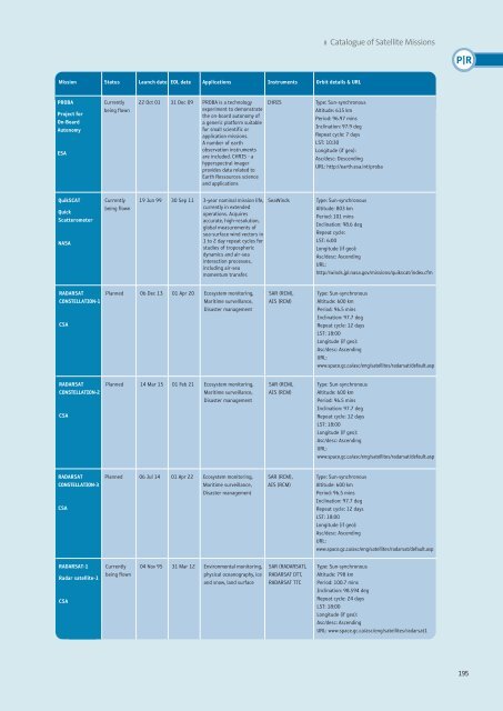
Mission Status Launch date EOL date Applications Instruments Orbit details & URL<br />
PROBA<br />
Project for<br />
On-Board<br />
Autonomy<br />
ESA<br />
Currently<br />
being flown<br />
22 Oct 01 31 Dec 09 PROBA is a technology<br />
experiment to demonstrate<br />
the on-board autonomy of<br />
a generic platform suitable<br />
for small scientific or<br />
application missions.<br />
A number of earth<br />
observation instruments<br />
are included. CHRIS - a<br />
hyperspectral imager<br />
provides data related to<br />
Earth Ressources science<br />
and applications<br />
CHRIS<br />
Type: Sun-synchronous<br />
Altitude: 615 km<br />
Period: 96.97 mins<br />
Inclination: 97.9 deg<br />
Repeat cycle: 7 days<br />
LST: 10:30<br />
Longitude (if geo):<br />
Asc/desc: Descending<br />
URL: http://earth.esa.int/proba<br />
QuikSCAT<br />
Quick<br />
Scatterometer<br />
NASA<br />
Currently<br />
being flown<br />
19 Jun 99 30 Sep 11 3-year nominal mission life,<br />
currently in extended<br />
operations. Acquires<br />
accurate, high-resolution,<br />
global measurements of<br />
sea-surface wind vectors in<br />
1 to 2 day repeat cycles for<br />
studies of tropospheric<br />
dynamics and air-sea<br />
interaction processes,<br />
including air-sea<br />
momentum transfer.<br />
SeaWinds<br />
Type: Sun-synchronous<br />
Altitude: 803 km<br />
Period: 101 mins<br />
Inclination: 98.6 deg<br />
Repeat cycle:<br />
LST: 6:00<br />
Longitude (if geo):<br />
Asc/desc: Ascending<br />
URL:<br />
http://winds.jpl.nasa.gov/missions/quikscat/index.cfm<br />
RADARSAT<br />
CONSTELLATION-1<br />
CSA<br />
Planned 06 Dec 13 01 Apr 20 Ecosystem monitoring,<br />
Maritime surveillance,<br />
Disaster management<br />
SAR (RCM),<br />
AIS (RCM)<br />
Type: Sun-synchronous<br />
Altitude: 600 km<br />
Period: 96.5 mins<br />
Inclination: 97.7 deg<br />
Repeat cycle: 12 days<br />
LST: 18:00<br />
Longitude (if geo):<br />
Asc/desc: Ascending<br />
URL:<br />
www.space.gc.ca/asc/eng/satellites/radarsat/default.asp<br />
RADARSAT<br />
CONSTELLATION-2<br />
CSA<br />
Planned 14 Mar 15 01 Feb 21 Ecosystem monitoring,<br />
Maritime surveillance,<br />
Disaster management<br />
SAR (RCM),<br />
AIS (RCM)<br />
Type: Sun-synchronous<br />
Altitude: 600 km<br />
Period: 96.5 mins<br />
Inclination: 97.7 deg<br />
Repeat cycle: 12 days<br />
LST: 18:00<br />
Longitude (if geo):<br />
Asc/desc: Ascending<br />
URL:<br />
www.space.gc.ca/asc/eng/satellites/radarsat/default.asp<br />
RADARSAT<br />
CONSTELLATION-3<br />
CSA<br />
Planned 06 Jul 14 01 Apr 22 Ecosystem monitoring,<br />
Maritime surveillance,<br />
Disaster management<br />
SAR (RCM),<br />
AIS (RCM)<br />
Type: Sun-synchronous<br />
Altitude: 600 km<br />
Period: 96.5 mins<br />
Inclination: 97.7 deg<br />
Repeat cycle: 12 days<br />
LST: 18:00<br />
Longitude (if geo):<br />
Asc/desc: Ascending<br />
URL:<br />
www.space.gc.ca/asc/eng/satellites/radarsat/default.asp<br />
RADARSAT-1<br />
Radar satellite-1<br />
CSA<br />
Currently<br />
being flown<br />
04 Nov 95 31 Mar 12 Environmental monitoring,<br />
physical oceanography, ice<br />
and snow, land surface<br />
SAR (RADARSAT),<br />
RADARSAT DTT,<br />
RADARSAT TTC<br />
Type: Sun-synchronous<br />
Altitude: 798 km<br />
Period: 100.7 mins<br />
Inclination: 98.594 deg<br />
Repeat cycle: 24 days<br />
LST: 18:00<br />
Longitude (if geo):<br />
Asc/desc: Ascending<br />
URL: www.space.gc.ca/asc/eng/satellites/radarsat1<br />
195


