

landbased
List of Satellite Missions (alphabetical) - ceos eo handbook
List of Satellite Missions (alphabetical) - ceos eo handbook
- No tags were found...

You also want an ePaper? Increase the reach of your titles
YUMPU automatically turns print PDFs into web optimized ePapers that Google loves.
C<br />
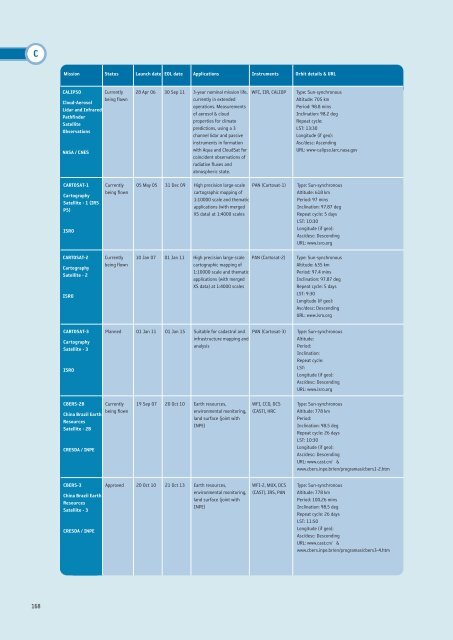
Mission Status Launch date EOL date Applications Instruments Orbit details & URL<br />
CALIPSO<br />
Currently<br />
being flown<br />
Cloud-Aerosol<br />
Lidar and Infrared<br />
Pathfinder<br />
Satellite<br />
Observations<br />
NASA / CNES<br />
28 Apr 06 30 Sep 11 3-year nominal mission life,<br />
currently in extended<br />
operations. Measurements<br />
of aerosol & cloud<br />
properties for climate<br />
predictions, using a 3<br />
channel lidar and passive<br />
instruments in formation<br />
with Aqua and CloudSat for<br />
coincident observations of<br />
radiative fluxes and<br />
atmospheric state.<br />
WFC, IIR, CALIOP<br />
Type: Sun-synchronous<br />
Altitude: 705 km<br />
Period: 98.8 mins<br />
Inclination: 98.2 deg<br />
Repeat cycle:<br />
LST: 13:30<br />
Longitude (if geo):<br />
Asc/desc: Ascending<br />
URL: www-calipso.larc.nasa.gov<br />
CARTOSAT-1<br />
Cartography<br />
Satellite - 1 (IRS<br />
P5)<br />
ISRO<br />
Currently<br />
being flown<br />
05 May 05 31 Dec 09 High precision large-scale<br />
cartographic mapping of<br />
1:10000 scale and thematic<br />
applications (with merged<br />
XS data) at 1:4000 scales<br />
PAN (Cartosat-1)<br />
Type: Sun-synchronous<br />
Altitude: 618 km<br />
Period: 97 mins<br />
Inclination: 97.87 deg<br />
Repeat cycle: 5 days<br />
LST: 10:30<br />
Longitude (if geo):<br />
Asc/desc: Descending<br />
URL: www.isro.org<br />
CARTOSAT-2<br />
Cartography<br />
Satellite - 2<br />
ISRO<br />
Currently<br />
being flown<br />
10 Jan 07 01 Jan 11 High precision large-scale<br />
cartographic mapping of<br />
1:10000 scale and thematic<br />
applications (with merged<br />
XS data) at 1:4000 scales<br />
PAN (Cartosat-2)<br />
Type: Sun-synchronous<br />
Altitude: 635 km<br />
Period: 97.4 mins<br />
Inclination: 97.87 deg<br />
Repeat cycle: 5 days<br />
LST: 9:30<br />
Longitude (if geo):<br />
Asc/desc: Descending<br />
URL: www.isro.org<br />
CARTOSAT-3<br />
Cartography<br />
Satellite - 3<br />
ISRO<br />
Planned 01 Jan 11 01 Jan 15 Suitable for cadastral and<br />
infrastructure mapping and<br />
analysis<br />
PAN (Cartosat-3)<br />
Type: Sun-synchronous<br />
Altitude:<br />
Period:<br />
Inclination:<br />
Repeat cycle:<br />
LST:<br />
Longitude (if geo):<br />
Asc/desc: Descending<br />
URL: www.isro.org<br />
CBERS-2B<br />
China Brazil Earth<br />
Resources<br />
Satellite - 2B<br />
CRESDA / INPE<br />
Currently<br />
being flown<br />
19 Sep 07 20 Oct 10 Earth resources,<br />
environmental monitoring,<br />
land surface (joint with<br />
INPE)<br />
WFI, CCD, DCS<br />
(CAST), HRC<br />
Type: Sun-synchronous<br />
Altitude: 778 km<br />
Period:<br />
Inclination: 98.5 deg<br />
Repeat cycle: 26 days<br />
LST: 10:30<br />
Longitude (if geo):<br />
Asc/desc: Descending<br />
URL: www.cast.cn/ &<br />
www.cbers.inpe.br/en/programas/cbers1-2.htm<br />
CBERS-3<br />
China Brazil Earth<br />
Resources<br />
Satellite - 3<br />
CRESDA / INPE<br />
Approved 20 Oct 10 21 Oct 13 Earth resources,<br />
environmental monitoring,<br />
land surface (joint with<br />
INPE)<br />
WFI-2, MUX, DCS<br />
(CAST), IRS, PAN<br />
Type: Sun-synchronous<br />
Altitude: 778 km<br />
Period: 100.26 mins<br />
Inclination: 98.5 deg<br />
Repeat cycle: 26 days<br />
LST: 11:50<br />
Longitude (if geo):<br />
Asc/desc: Descending<br />
URL: www.cast.cn/ &<br />
www.cbers.inpe.br/en/programas/cbers3-4.htm<br />
168


