

landbased
List of Satellite Missions (alphabetical) - ceos eo handbook
List of Satellite Missions (alphabetical) - ceos eo handbook
- No tags were found...

Create successful ePaper yourself
Turn your PDF publications into a flip-book with our unique Google optimized e-Paper software.
8 Catalogue of Satellite Missions<br />
T|V<br />
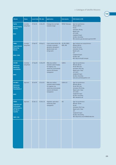
Mission Status Launch date EOL date Applications Instruments Orbit details & URL<br />
TopSat<br />
Optical Imaging<br />
Satellite<br />
BNSC<br />
Currently<br />
being flown<br />
27 Oct 05 31 Dec 09 Prototype low-cost highresolution<br />
imager<br />
TOPSAT Telescope<br />
Type: Sun-synchronous<br />
Altitude: 600 km<br />
Period:<br />
Inclination: 98 deg<br />
Repeat cycle:<br />
LST: 10:30<br />
Longitude (if geo):<br />
Asc/desc: Ascending<br />
URL: www.bnsc.gov.uk/content.aspx?nid=5907<br />
TRMM<br />
Tropical Rainfall<br />
Measuring<br />
Mission<br />
NASA / JAXA<br />
Currently<br />
being flown<br />
27 Nov 97 30 Sep 11 3-year nominal mission life,<br />
currently in extended<br />
operations. Atmospheric<br />
dynamics/water and<br />
energy cycles<br />
LIS, PR, CERES,<br />
VIRS, TMI<br />
Type: Inclined, non-sunsynchronous<br />
Altitude: 405 km<br />
Period: 93.5 mins<br />
Inclination: 35 deg<br />
Repeat cycle:<br />
LST:<br />
Longitude (if geo):<br />
Asc/desc: N/A<br />
URL: http://trmm.gsfc.nasa.gov<br />
UK-DMC<br />
UK Disaster<br />
Monitoring<br />
Constellation<br />
BNSC<br />
Currently<br />
being flown<br />
27 Sep 03 31 Dec 09 Wide area, medium<br />
resolution optical imaging<br />
for mapping, crop<br />
monitoring, environmental<br />
resource and disaster<br />
management<br />
SLIM-6<br />
Type: Sun-synchronous<br />
Altitude: 686 km<br />
Period: 98.4 mins<br />
Inclination: 98.2 deg<br />
Repeat cycle: 5 days<br />
LST: 10:15<br />
Longitude (if geo):<br />
Asc/desc: Ascending<br />
www.sstl.co.uk/index.php?loc=113<br />
UK-DMC2<br />
UK Disaster<br />
Monitoring<br />
Constellation 2<br />
BNSC<br />
Approved 30 Jul 09 25 Jul 14 Wide area, medium<br />
resolution optical imaging<br />
for mapping, crop<br />
monitoring, environmental<br />
resource and disaster<br />
management<br />
SLIM-6-22<br />
Type: Sun-synchronous<br />
Altitude: 686 km<br />
Period: 98.5 mins<br />
Inclination: 98.14 deg<br />
Repeat cycle: 5 days<br />
LST: 10:30<br />
Longitude (if geo):<br />
Asc/desc: Ascending<br />
URL: www.dmcii.com<br />
VENUS<br />
Vegetation and<br />
Environment<br />
monitoring on a<br />
New Micro-<br />
Satellite<br />
CNES / ISA<br />
Approved 01 Dec 11 01 Dec 14 Vegetation, agriculture<br />
monitoring, water<br />
management<br />
VSC<br />
Type: Sun-synchronous<br />
Altitude: 720 km<br />
Period:<br />
Inclination: 98.27 deg<br />
Repeat cycle: 2 days<br />
LST:<br />
Longitude (if geo):<br />
Asc/desc: Descending<br />
URL: http://smsc.cnes.fr/VENUS/index.htm<br />
205


