

landbased
List of Satellite Missions (alphabetical) - ceos eo handbook
List of Satellite Missions (alphabetical) - ceos eo handbook
- No tags were found...

You also want an ePaper? Increase the reach of your titles
YUMPU automatically turns print PDFs into web optimized ePapers that Google loves.
8 Catalogue of Satellite Missions<br />
F<br />
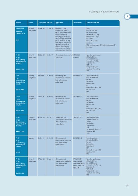
Mission Status Launch date EOL date Applications Instruments Orbit details & URL<br />
FORMOSAT-2<br />
FORMOSA<br />
Satellite No. 2<br />
NSPO<br />
Currently<br />
being flown<br />
21 May 04 21 May 10 Providing 2 meter<br />
resolution of image in<br />
panchromatic band and 8<br />
meter resolution in<br />
multispectral bands with<br />
swath of 24 km with daily<br />
revisit capability for and<br />
large ground coverage for<br />
applications including<br />
disaster investigation,<br />
environment monitoring,<br />
and vegetation evaluation.<br />
Type:<br />
Altitude: 891 km<br />
Period: 103 mins<br />
Inclination: 97.7 deg<br />
Repeat cycle: 1 days<br />
LST: 10:00<br />
Longitude (if geo):<br />
Asc/desc:<br />
URL: www.nspo.org.tw/2005e/projects/project2/<br />
intro.htm<br />
FY-1D<br />
FY-1D<br />
Polar-orbiting<br />
Meteorological<br />
Satellite<br />
NRSCC / CMA<br />
Currently<br />
being flown<br />
15 May 02 31 Dec 09 Meteorology, Environmental<br />
monitoring<br />
MVISR (10<br />
channels)<br />
Type: Sun-synchronous<br />
Altitude: 863 km<br />
Period: 102.3 mins<br />
Inclination: 98.8 deg<br />
Repeat cycle:<br />
LST: 9:00<br />
Longitude (if geo):<br />
Asc/desc: Descending<br />
URL:<br />
FY-2C<br />
FY-2C<br />
Geostationary<br />
Meteorological<br />
Satellite<br />
NRSCC / CMA<br />
Currently<br />
being flown<br />
19 Oct 04 31 Dec 09 Meteorology and<br />
environmental monitoring<br />
Data collection and<br />
redistribution<br />
IVISSR (FY-2)<br />
Type: Geostationary<br />
Altitude: 36000 km<br />
Period:<br />
Inclination:<br />
Repeat cycle:<br />
LST:<br />
Longitude (if geo): -105<br />
Asc/desc: N/A<br />
URL:<br />
FY-2D<br />
FY-2D<br />
Geostationary<br />
Meteorological<br />
Satellite<br />
NRSCC / CMA<br />
Currently<br />
being flown<br />
08 Dec 06 08 Dec 09 Meteorology and<br />
environmental monitoring<br />
Data collection and<br />
redistribution<br />
IVISSR (FY-2)<br />
Type: Geostationary<br />
Altitude: 36000 km<br />
Period:<br />
Inclination:<br />
Repeat cycle:<br />
LST:<br />
Longitude (if geo): -105<br />
Asc/desc: N/A<br />
URL:<br />
FY-2E<br />
FY-2E<br />
Geostationary<br />
Meteorological<br />
Satellite<br />
NRSCC / CMA<br />
Currently<br />
being flown<br />
26 Dec 08 31 Dec 11 Meteorology and<br />
environmental monitoring<br />
Data collection and<br />
redistribution<br />
IVISSR (FY-2)<br />
Type: Geostationary<br />
Altitude: 36000 km<br />
Period:<br />
Inclination:<br />
Repeat cycle:<br />
LST:<br />
Longitude (if geo): -105<br />
Asc/desc: N/A<br />
URL:<br />
FY-2F<br />
FY-2F<br />
Geostationary<br />
Meteorological<br />
Satellite<br />
NRSCC<br />
Approved 31 Dec 11 31 Dec 16 Meteorology and<br />
environmental monitoring<br />
Data collection and<br />
redistribution<br />
IVISSR (FY-2)<br />
Type: Geostationary<br />
Altitude: 36000 km<br />
Period:<br />
Inclination:<br />
Repeat cycle:<br />
LST:<br />
Longitude (if geo): -105<br />
Asc/desc: N/A<br />
URL:<br />
FY-3A<br />
FY-3A<br />
Polar-orbiting<br />
Meteorological<br />
Satellite<br />
NRSCC / CMA<br />
Currently<br />
being flown<br />
27 May 08 31 May 11 Meteorology and<br />
environmental monitoring<br />
data collection and<br />
redistribution.<br />
IRAS, MWAS,<br />
MWHS, MWRI,<br />
VIRR, ERM, MERSI,<br />
MWTS, TOU/SBUS,<br />
SEM, SIM<br />
Type: Sun-synchronous<br />
Altitude: 830 km<br />
Period: 101 mins<br />
Inclination: 98.753 deg<br />
Repeat cycle:<br />
LST: 10:10<br />
Longitude (if geo):<br />
Asc/desc: Descending<br />
URL:<br />
175


