Kongsberg Seatex
Kongsberg Seatex
Kongsberg Seatex

Create successful ePaper yourself
Turn your PDF publications into a flip-book with our unique Google optimized e-Paper software.
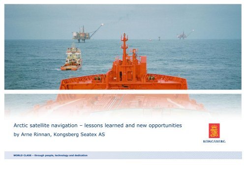
Arctic satellite navigation – lessons learned and new opportunities<br />
by Arne Rinnan, <strong>Kongsberg</strong> <strong>Seatex</strong> AS<br />
WORLD CLASS – through people, technology and dedication
Outline<br />
• Introduction<br />
• Weather conditions<br />
• Satellite coverage<br />
• Aurora impact<br />
• GNSS corrections<br />
• Observations<br />
• New opportunities<br />
• Conclusion<br />
/ 2 / 20-Nov-12
INTRODUCTION<br />
/ 3 / 20-Nov-12
4 / 20-Nov-12<br />
<strong>Kongsberg</strong> <strong>Seatex</strong> AS
<strong>Kongsberg</strong> <strong>Seatex</strong> - Business Areas<br />
DP Reference<br />
Systems<br />
Marine Seismic<br />
Positioning and<br />
Control<br />
Attitude<br />
Determination<br />
Systems<br />
GNSS Systems and<br />
Projects<br />
Load and stability<br />
calculations
KOG Global footprint
Routes of the Viking Explorers<br />
Viking routes<br />
/ 7 / 20-Nov-12<br />
Sundial: the Viking ”sextant”
Monitoring Arctic Navigation from Space<br />
• AISSat-1 – experimental nano satellite with<br />
AIS receiver payload<br />
• Designed for monitoring AIS targets in arctic<br />
regions<br />
• Polar orbit, 600 km altitude<br />
AISSat-1 model<br />
• Providing data from July 2010<br />
Project partners<br />
/ 8 / 20-Nov-12
AISSat-1 observations, 12 July, 2010<br />
Traffic expected to increase in the years to come
WEATHER CONDITIONS<br />
/ 10 / 20-Nov-12
Temperatures in the Arctic<br />
°C °F<br />
Average July<br />
temperatures<br />
Average January<br />
temperatures<br />
-10 to +10°C 14 to 50°F<br />
-40 to +0°C -40 to +32°F<br />
Extreme temperatures ~ -50°C ~ -58°F<br />
Typical GNSS antenna<br />
specifications<br />
-40°C<br />
-40°F<br />
Conclusion:<br />
Most GNSS antennas will work fine<br />
under almost all temperature<br />
conditions in the Arctic<br />
Arctic defined by the 10°C isotherm in July,<br />
Wikipedia, 2010-08-25<br />
/ 11 / 20-Nov-12
Iceload on GNSS Antennas<br />
• Surprisingly little is known about the<br />
effect of ice-load on a GNSS antenna<br />
• Snow does probably not have any<br />
significant effect<br />
• A 1.25 cm wet surface ice loading will<br />
(Ref: O’Keefe et al):<br />
• Reduce the SNR with 3 dB<br />
• Increase the rms position error of 1 m<br />
• Increase the number of cycle slips<br />
significantly<br />
Conclusion:<br />
Ice building up on the GNSS antenna<br />
doesn’t make any good!<br />
Ref: http://farm1.static.flickr.com/35/100361821_5d58d82777.jpg<br />
/ 12 / 20-Nov-12
SATELLITE COVERAGE<br />
/ 13 / 20-Nov-12
Significance of the Orbit Inclination Angle<br />
• The highest latitude a satellite<br />
can pass zenith is equal to the<br />
orbit inclination angle<br />
• Any GPS satellite will eventually<br />
be visible from any position in<br />
the Arctic<br />
• A geostationary satellite cannot<br />
be observed above a latitude of<br />
about 75° with e.g. a 5°<br />
elevation mask constraint. The<br />
longitude position might reduce<br />
this limit.<br />
Glonass satellite<br />
(64.8° inclination)<br />
N<br />
S<br />
GPS satellite<br />
(55° inclination)<br />
GEO satellite<br />
(0° inclination)<br />
Glonass, GPS and GEO satellite inclination angles<br />
/ 14 / 20-Nov-12
GPS Satellite Trajectories at Different Latitudes<br />
Observer’s Latitude: 30°N<br />
No GPS satellites observed below a<br />
certain elevation in a northern<br />
direction leads to less accuracy in<br />
North/South direction<br />
Observer’s Latitude: 55°N<br />
The highest latitude where a GPS<br />
satellites will pass zenith. Some<br />
GPS satellites observed at a very<br />
low elevation angle in a northern<br />
direction<br />
Observer’s Latitude: 75°N<br />
No GPS satellites observed above a<br />
certain elevation angle leads to less<br />
accuracy in height<br />
Plots generated by use of GeoSky II (Fugro)<br />
/ 15 / 20-Nov-12
Visible GNSS Satellites at Different Latitudes<br />
• HDOP and number of visible<br />
satellites improves at high<br />
latitudes<br />
30°N<br />
• PDOP peaks at high latitudes<br />
because of fewer high<br />
elevation satellites and<br />
causes some degradation of<br />
vertical accuracy<br />
55°N<br />
Conclusion:<br />
Satellite coverage in Arctic is<br />
good especially with a<br />
combined satellite constellation<br />
75°N<br />
Plots generated by use of GeoSky II (Fugro)<br />
/ 16 / 20-Nov-12
Availability of Signals from Geo Satellites<br />
• Used for communication and<br />
distribution of differential signals<br />
• Some additional margin needed<br />
due to<br />
• roll movement<br />
• obstructions in a southern direction<br />
• Signal disturbance caused by high<br />
solar activity<br />
Conclusion:<br />
Signals from Geo satellites will be<br />
less available in Arctic regions<br />
Limited visibility of Geo satellites<br />
/ 17 / 20-Nov-12
Influence of the Ionosphere<br />
AURORA IMPACT<br />
/ 18 / 20-Nov-12
A Pioneer, Prof. Kristian Birkeland<br />
• An outstanding Norwegian<br />
physicist, born in 1867<br />
• Demonstrated artificial polar light<br />
in several “terella” experiments<br />
as shown on the Norwegian ”200<br />
kroner” banknote<br />
• Proved several ionospheric effects<br />
that were not verified until about<br />
50 years later<br />
/ 19 / 20-Nov-12
The Sun and the Sunspots<br />
• Sunspots have been observed and counted, more or less<br />
systematically, for thousands of years<br />
• Sunspot activity is known to have an effect on solar wind<br />
and conditions in the ionosphere<br />
• Modern infrastructure is vulnerable to these effects<br />
/ 20 / 20-Nov-12
Different Scales of Ionospheric Effects<br />
• Large-scale:<br />
• Basically the density of charged particles in<br />
the ionosphere<br />
• Medium-scale:<br />
• F-layer patches moving over the auroral<br />
oval<br />
• Small-scale:<br />
• Scintillations within the auroral oval causing<br />
variations over a few km<br />
The auroral oval (www.mssl.ucl.ac.uk)<br />
/ 21 / 20-Nov-12
Effect on GPS signals - Cycle 22<br />
”Single frequency users will have to<br />
rely on a model of the ionospheric<br />
group delay, and the observations<br />
made in this trial verifies that this<br />
model will have a very poor fit for<br />
high latitude data.”<br />
Northern Light<br />
/ 22 / 20-Nov-12
The Effect of Cycle 24?<br />
• Degraded GNSS accuracy during<br />
”bad ionospheric weather”<br />
• Loss of signals from<br />
communication satellites (Geo)<br />
during high ionospheric activity<br />
• Increased risk of knock-out of<br />
electronics and power due to<br />
electromagnetic pulses like in<br />
Quebec in 1989<br />
Cycle 24 is reaching<br />
its maximum!<br />
/ 23 / 20-Nov-12
GNSS CORRECTIONS<br />
/ 24 / 20-Nov-12
GNSS Correction Main Categories<br />
• Local DGPS L1 Service (e.g. IALA)<br />
• Regional SBAS services (e.g. WAAS, EGNOS, MSAS)<br />
• Global orbit/clock services (e.g. Fugro, Veripos, C&C)<br />
/ 25 / 20-Nov-12
Local DGPS L1 Services<br />
IALA beacon coverage in Europe and North America<br />
/ 26 / 20-Nov-12
Local DGPS Services in the Arctic<br />
• Out of range of local DGPS services in most Arctic areas<br />
• Degraded accuracy caused by ionospheric activity to be<br />
expected<br />
• Ionospheric activity might limit GNSS satellite tracking at the<br />
reference stations<br />
/ 27 / 20-Nov-12
28 / 20-Nov-12<br />
Regional SBAS Service Coverage
The SBAS Ionospheric Model<br />
• Calculating Ionospheric Grid<br />
Point Delay tables<br />
• The limitations of the method<br />
will be density of grid points<br />
and ground based monitoring<br />
points<br />
• Compensates for large-scale<br />
and, to some extent, medium<br />
scale effects<br />
• Do not help much for smallscale<br />
effects (scintillations)<br />
/ 29 / 20-Nov-12
Regional SBAS Performance<br />
• Most Arctic areas are outside SBAS service area<br />
• Monitoring stations mostly deployed within service area<br />
• Ionospheric model<br />
• Availability of correction signals from Geo satellites limited<br />
• Ionospheric scintillations will cause degraded accuracy and<br />
integrity<br />
/ 30 / 20-Nov-12
Global Orbit/Clock<br />
• Orbit/clock corrections are global and<br />
will not be degraded in the Arctic<br />
• Small 2nd order effects might cause a<br />
small accuracy degradation of<br />
ionospheric compensation during<br />
scintillations<br />
• GPS L2 will be vulnerable to distortion<br />
of the satellite signal through an<br />
active ionosphere<br />
• Availability of correction signals from<br />
Fugro G2<br />
Geo satellites will be limited<br />
/ 31 / 20-Nov-12
Coverage of Orbit/Clock Corrections<br />
Fugro Orbit/Clock Service Coverage in Arctic Regions<br />
/ 32 / 20-Nov-12
Ionospheric Scintillations<br />
OBSERVATIONS<br />
/ 33 / 20-Nov-12
Northern Light, Oslo 3-4 August 2010<br />
Photo: Ole Ørpen - Fugro Seastar<br />
Northern Light prediction (yr.no)<br />
/ 34 / 20-Nov-12
Loosing Lock on GPS L2, Tromsø<br />
Loss of L2 signal for three high elevation GPS satellites (11, 14, 32),<br />
Caused by ionospheric scintillations<br />
/ 35 / 20-Nov-12
m<br />
Iono Effect on L1 Solution, Tromsø<br />
VBS solution, No Tromsø (700:430 km, 632:787 km, 670:1381 km)<br />
Height Error North Error East Error<br />
3.00<br />
2.50<br />
2.00<br />
1.50<br />
1.00<br />
0.50<br />
0.00<br />
-0.50<br />
-1.00<br />
-1.50<br />
-2.00<br />
00:00:00 01:00:00 02:00:00 03:00:00<br />
Time UTC 4 April 2010<br />
/ 36 / 20-Nov-12
37 / 20-Nov-12<br />
Iono Effect on GPS Orbit/Clock Solution, Tromsø
38 / 20-Nov-12<br />
Iono Effect on GPS/Glonass Orbit/Clock, Tromsø
NEW OPPORTUNITIES<br />
/ 39 / 20-Nov-12
The Geopolitcal Map<br />
October 1, 2007<br />
/ 40 / 20-Nov-12
Galileo Galileo<br />
/ 41 / 20-Nov-12
Galileo launch<br />
Successful launch of the first<br />
four Galileo IOV satellittes<br />
2011-10-21 and 2012-10-12<br />
Photo: ESA<br />
42
43 / 20-Nov-12<br />
WORLD CLASS – through people, technology and dedication
Arctic Test Bed<br />
/ 44 / WORLD CLASS – through people, technology and dedication<br />
20-Nov-12
45 / 20-Nov-12<br />
Challenging Offshore Operations
MARENOR<br />
• Project owner: EMGS<br />
• Project management: Marintek<br />
• Partners: Remøy, Sintef ICT,<br />
KSAT, Telenor, UniS, <strong>Kongsberg</strong><br />
<strong>Seatex</strong><br />
• Financed by the Norwegian<br />
Research Council<br />
• Total budget 21 mill<br />
• Project Period: 2012 -2015<br />
Predicting performance of navigation and communication systems in Arctic<br />
Regions<br />
/ 46 / 20.11.2012
MARPOT<br />
• Project owner: <strong>Kongsberg</strong> <strong>Seatex</strong><br />
• Project management: Sintef F&H<br />
• Partners: <strong>Kongsberg</strong> <strong>Seatex</strong>,<br />
Sintef, KSAT, Simicon, Semekor<br />
• Reference Group: Not formally<br />
established yet<br />
• Financed by the Norwegian<br />
Research Council<br />
• Total budget 11 mill NOK wherof<br />
45% is financed by NRC<br />
• Project Period: 01.01.11 – 31.12.12<br />
KV Barentshav<br />
New technology to improve navigation safety, positioning, surveillance,<br />
emergency response and effectiveness of infrastructure<br />
/ 47 / 20.11.2012
Technology demonstrator KV Barentshav – Aug 2012<br />
• 1 week demonstrations<br />
• Organised under “MARPOT” (KSX)<br />
• Focus on challenges of Arctic operations:<br />
GNSS, communication, surveillance and<br />
SIMOPS
Test equipment<br />
• SIMOPS with new broadband and longrange<br />
radio<br />
•<br />
• DPS 232 including DGNSS demodulator (<br />
G2/RTCM)<br />
• GNSS receiver for scintillation<br />
measurements<br />
• NG AIS «Super AIS» for vessel and<br />
Aerostat/UAS<br />
• Ice Profiler (KM Subsea)<br />
49
Technology demonstrator KV Barentshav – Aug 2012
CONCLUSION<br />
/ 51 / 20-Nov-12
Conclusion<br />
• Satellite navigation will mostly work fine in Arctic areas but<br />
there is still need for improvement<br />
• Some degradation due to ionospheric scintillations has to be<br />
expected but combining GPS and other GNSS solutions will<br />
minimise the problem<br />
• High accuracy GNSS will require better coverage by reliable<br />
communication links<br />
• The political significance of the Arctic is driving the<br />
development of new technology and solutions<br />
/ 52 / 20-Nov-12