

Northeast San Fernando Valley
NEV%20Strategy%20Publication%20Draft%20Revision%20I
NEV%20Strategy%20Publication%20Draft%20Revision%20I

You also want an ePaper? Increase the reach of your titles
YUMPU automatically turns print PDFs into web optimized ePapers that Google loves.
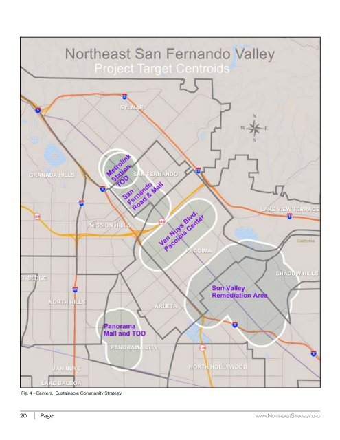
Fig. 4 - Centers, Sustainable Community Strategy<br />
Section 4 - Target Areas<br />
<strong>Northeast</strong> <strong>San</strong> <strong>Fernando</strong> <strong>Valley</strong><br />
Given the extensive size and population of the<br />
<strong>Northeast</strong> <strong>Valley</strong>, the selection of initial target areas<br />
is key to the potential success of the endeavor.<br />
Often the areas of greatest challenge are also the<br />
areas of greatest opportunity.<br />
The project team has selected five initial “centroids”<br />
based on their profile as centers, their proximity to<br />
existing or proposed transportation, their zoning,<br />
or in the case of Sun <strong>Valley</strong>’s landfills and heavy<br />
industrial lands, their environmental challenges.<br />
For analysis, in each case the relevant study area<br />
adopted is a half-mile radius or band catchment<br />
area around each centroid.<br />
The half-mile distance has become accepted for<br />
gauging a transit station’s catchment area in the<br />
United States and is the de facto standard for the<br />
planning of U.S. transit-oriented developments<br />
(TODs). This radius is loosely based on the distance<br />
that people are willing to walk to transit.<br />
Results support the use of a 0.25-mile catchment<br />
area around transit for jobs and a 0.5-mile catchment<br />
area for population. These are good starting<br />
points for considering transit-oriented land use<br />
policy or collecting labor-intensive data. 1<br />
The selection of the Sylmar/<strong>San</strong> <strong>Fernando</strong> Metrolink<br />
Station is consistent with Metro’s round of<br />
grants to cities with planning zoning jurisdiction<br />
over the areas surrounding Metrolink Stations.<br />
The City of <strong>San</strong> <strong>Fernando</strong> covers roughly half the<br />
area around the station and was awarded a grant<br />
for the creation of a “Station Area Plan” to better<br />
accommodate Transit-Oriented Development. This<br />
station will also be the terminus of the proposed<br />
East <strong>Valley</strong> Transit Corridor, making it an ideal TOD<br />
prospect.<br />
It would be useful to have a complementary plan for<br />
the semi-circle in the City of Los Angeles as well.<br />
Because of their proximity, the Metrolink Station<br />
half-mile radius falls almost entirely within in the<br />
<strong>San</strong> <strong>Fernando</strong> Road centroid (see Figure 4). The<br />
Mall portion of <strong>San</strong> <strong>Fernando</strong> Road already has a<br />
hardscape in place that can be enhanced at minimal<br />
expense. The tenant mix will require intervention<br />
in order to offer the full array of goods, services<br />
and amenities sought by local residents<br />
Over the past several decades, the tenant mix on<br />
<strong>San</strong> <strong>Fernando</strong> Road has lost some of its appeal by<br />
1 Guerra, Erick; Cervero, Robert; Tischler, Daniel “Half-Mile Circle-<br />
Does It Best Represent Transit Station Catchments?” Transportation<br />
Research Record: Journal of the Transportation Research Board,<br />
1981<br />
no longer offering a complete array of goods and<br />
services.<br />
The selection of Van Nuys Boulevard in Pacoima,<br />
between Laurel Canyon Boulevard and <strong>San</strong> <strong>Fernando</strong><br />
Road, is consistent with the “Great Streets”<br />
program in the City of Los Angeles, and with the<br />
Urban Land Institute’s “Healthy Corridors” targets.<br />
It is a classic Southern California “main street” and<br />
serves as the backbone for the Pacoima center.<br />
The Panorama City shopping area came into being<br />
in the 1960s, one of the first major shopping centers<br />
(turned Panorama Mall) in the region. Shopping<br />
occupies both sides of Van Nuys Boulevard,<br />
and the parcels are unusually deep. The mall was<br />
enclosed and stores added.<br />
The original Broadway anchor was joined by a<br />
J.W. Robinsons, Montgomery Ward, and Orbachs,<br />
among others. The east side of the street features<br />
three major blocks of inline stores, all with parking<br />
in the rear. The Macerich company recently sold the<br />
Panorama Mall to Primestor, and the long-abandoned<br />
Panorama Towers office building has been<br />
sold as well.<br />
The Sun <strong>Valley</strong> Remediation area is the most environmentally<br />
challenged, and is composed of decommissioned<br />
landfills, storage areas, auto wrecking,<br />
and heavy industry. The long-term potential of<br />
repurposing some of these properties is excellent.<br />
The <strong>San</strong> <strong>Fernando</strong> Mall already has the necessary configuration for<br />
a Transit-Oriented District, but is in need of intervention to become a<br />
complete street with a balanced tenant mix<br />
20 Page www.<strong>Northeast</strong>Strategy.org<br />
Draft Revision I - May 25, 2016<br />
Page 21