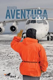
DAP AVENTURA 2016 - 2017
Los invitamos a conocer nuestra mirada, a través de esta nueva edición digital de revista "AVENTURA: Al Fin del Mundo", temporada 2015-2016. Cuéntanos qué te parece en facebook.com/grupodap _______/________ We invite you to know our world, in this new digital edition of "ADVENTURE: At the End of the World" 2015-2016 season. Tell us what you think on facebook.com/grupodap Enjoy!
Los invitamos a conocer nuestra mirada, a través de esta nueva edición digital de revista "AVENTURA: Al Fin del Mundo", temporada 2015-2016.
Cuéntanos qué te parece en facebook.com/grupodap _______/________
We invite you to know our world, in this new digital edition of "ADVENTURE: At the End of the World" 2015-2016 season.
Tell us what you think on facebook.com/grupodap
Enjoy!

You also want an ePaper? Increase the reach of your titles
YUMPU automatically turns print PDFs into web optimized ePapers that Google loves.
Aventura al fin del mundo <strong>2016</strong> - <strong>2017</strong><br />
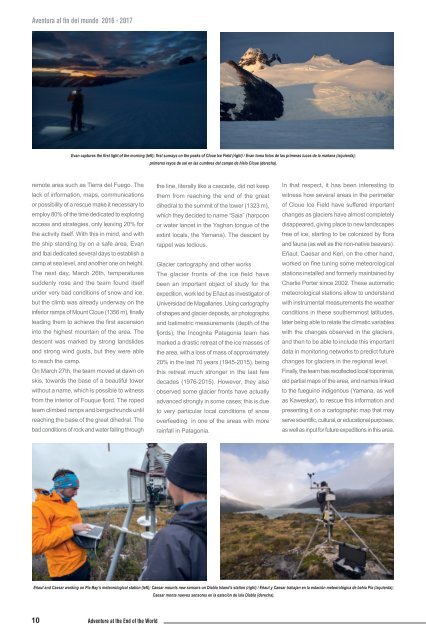
Evan captures the first light of the morning (left); first sunrays on the peaks of Cloue Ice Field (right) / Evan toma fotos de las primeras luces de la mañana (izquierda);<br />
primeros rayos de sol en las cumbres del campo de hielo Cloue (derecha).<br />
remote area such as Tierra del Fuego. The<br />
lack of information, maps, communications<br />
or possibility of a rescue make it necessary to<br />
employ 80% of the time dedicated to exploring<br />
access and strategies, only leaving 20% for<br />
the activity itself. With this in mind, and with<br />
the ship standing by on a safe area, Evan<br />
and Ibai dedicated several days to establish a<br />
camp at sea level, and another one on height.<br />
The next day, March 26th, temperatures<br />
suddenly rose and the team found itself<br />
under very bad conditions of snow and ice,<br />
but the climb was already underway on the<br />
inferior ramps of Mount Cloue (1356 m), finally<br />
leading them to achieve the first ascension<br />
into the highest mountain of the area. The<br />
descent was marked by strong landslides<br />
and strong wind gusts, but they were able<br />
to reach the camp.<br />
On March 27th, the team moved at dawn on<br />
skis, towards the base of a beautiful tower<br />
without a name, which is possible to witness<br />
from the interior of Fouque fjord. The roped<br />
team climbed ramps and bergschrunds until<br />
reaching the base of the great dihedral. The<br />
bad conditions of rock and water falling through<br />
the line, literally like a cascade, did not keep<br />
them from reaching the end of the great<br />
dihedral to the summit of the tower (1323 m),<br />
which they decided to name “Saia” (harpoon<br />
or water lancet in the Yaghan tongue of the<br />
extint locals, the Yamana). The descent by<br />
rappel was tedious.<br />
Glacier cartography and other works<br />
The glacier fronts of the ice field have<br />
been an important object of study for the<br />
expedition, work led by Eñaut as investigator of<br />
Universidad de Magallanes. Using cartography<br />
of shapes and glacier deposits, air photographs<br />
and batimetric measurements (depth of the<br />
fjords), the Incognita Patagonia team has<br />
marked a drastic retreat of the ice masses of<br />
the area, with a loss of mass of approximately<br />
20% in the last 70 years (1945-2015), being<br />
this retreat much stronger in the last few<br />
decades (1976-2015). However, they also<br />
observed some glacier fronts have actually<br />
advanced strongly in some cases; this is due<br />
to very particular local conditions of snow<br />
overfeeding in one of the areas with more<br />
rainfall in Patagonia.<br />
In that respect, it has been interesting to<br />
witness how several areas in the perimeter<br />
of Cloue Ice Field have suffered important<br />
changes as glaciers have almost completely<br />
disappeared, giving place to new landscapes<br />
free of ice, starting to be colonized by flora<br />
and fauna (as well as the non-native beavers).<br />
Eñaut, Caesar and Keri, on the other hand,<br />
worked on fine tuning some meteorological<br />
stations installed and formerly maintained by<br />
Charlie Porter since 2002. These automatic<br />
meteorological stations allow to understand<br />
with instrumental measurements the weather<br />
conditions in these southernmost latitudes,<br />
later being able to relate the climatic variables<br />
with the changes observed in the glaciers,<br />
and then to be able to include this important<br />
data in monitoring networks to predict future<br />
changes for glaciers in the regional level.<br />
Finally, the team has recollected local toponimia,<br />
old partial maps of the area, and names linked<br />
to the fueguino indigenous (Yamana, as well<br />
as Kaweskar), to rescue this information and<br />
presenting it on a cartographic map that may<br />
serve scientific, cultural, or educational purposes,<br />
as well as input for future expeditions in this area.<br />
Eñaut and Caesar working on Pía Bay’s meteorological station (left); Caesar mounts new sensors on Diablo Island’s station (right) / Eñaut y Caesar trabajan en la estación meteorológica de bahía Pía (izquierda);<br />
Caesar monta nuevos sensores en la estación de isla Diablo (derecha).<br />
10 Adventure at the End of the World