chapter - Atmospheric and Oceanic Science
chapter - Atmospheric and Oceanic Science
chapter - Atmospheric and Oceanic Science

Create successful ePaper yourself
Turn your PDF publications into a flip-book with our unique Google optimized e-Paper software.
The Chaco is the second biome in extension of South America. It corresponds<br />
to an alluvional area that is located East from the Andes mountain range, formed by<br />
the deposit of sediments, mainly from the Bermejo <strong>and</strong> Pilcomayo rivers. Since the<br />
Bermejo is the only river whose waters starts at the Andes <strong>and</strong> reaches the Paraguay<br />
River, it constitutes a natural ecological corridor among the puna ecosystems in the<br />
mountain, the yungas forest <strong>and</strong> the dry <strong>and</strong> humid areas of El Chaco plains.<br />
The Pampas's plain, due to their dimensions, is the third ecosystem of global<br />
importance. The most fertile soils in the La Plata basin are located in these plains<br />
<strong>and</strong> since long ago the agricultural production has settled in the area.<br />
The territory of the basin is completed by other key ecosystems of South<br />
America: the Cerrado, to the North, of a wide biological diversity <strong>and</strong> the Mata<br />
Atlantica, to the Northeast, at present characterized mainly by a strong deforestation<br />
of their original forests that have been reduced to 4% of its primary state.<br />
These data indicate the abundance <strong>and</strong> quality of the natural resources <strong>and</strong> the<br />
natural productivity, goods <strong>and</strong> services that these ecosystems provide. They also<br />
show how significant it has been <strong>and</strong> it's still being the availability, both in quality<br />
<strong>and</strong> quantity, of their water resources for the sustainability of the development<br />
process of the region.<br />
4.4. Characteristics of the sub-basins<br />
Physiography <strong>and</strong> Hydrology<br />
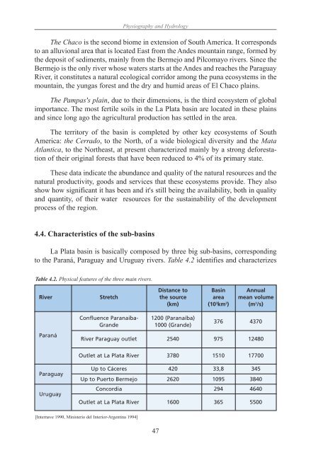
La Plata basin is basically composed by three big sub-basins, corresponding<br />
to the Paraná, Paraguay <strong>and</strong> Uruguay rivers. Table 4.2 identifies <strong>and</strong> characterizes<br />
Table 4.2. Physical features of the three main rivers.<br />
Distance to Basin Annual<br />
River Stretch the source area mean volume<br />
(km) (10 3 km 2 ) (m 3 /s)<br />
Paraná<br />
Paraguay<br />
Uruguay<br />
Confluence Paranaíba- 1200 (Paranaíba)<br />
Gr<strong>and</strong>e 1000 (Gr<strong>and</strong>e)<br />
47<br />
376 4370<br />
River Paraguay outlet 2540 975 12480<br />
Outlet at La Plata River 3780 1510 17700<br />
Up to Cáceres 420 33,8 345<br />
Up to Puerto Bermejo 2620 1095 3840<br />
Concordia 294 4640<br />
Outlet at La Plata River 1600 365 5500<br />
[Internave 1990, Ministerio del Interior-Argentina 1994]