Caribbean Beat — 25th Anniversary Edition — March/April 2017 (#144)
A calendar of events; music, film, and book reviews; travel features; people profiles, and much more.
A calendar of events; music, film, and book reviews; travel features; people profiles, and much more.

You also want an ePaper? Increase the reach of your titles
YUMPU automatically turns print PDFs into web optimized ePapers that Google loves.
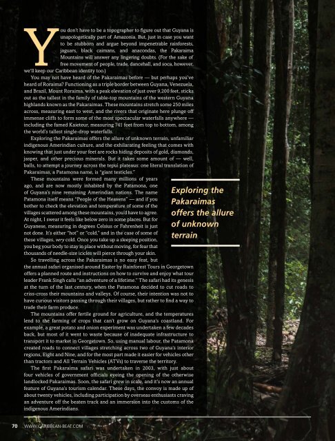
You don’t have to be a topographer to figure out that Guyana is<br />
unapologetically part of Amazonia. But, just in case you want<br />
to be stubborn and argue beyond impenetrable rainforests,<br />
jaguars, black caimans, and anacondas, the Pakaraima<br />
Mountains will answer any lingering doubts. (For the sake of<br />
free movement of people, trade, dancehall, and soca, however,<br />
we’ll keep our <strong>Caribbean</strong> identity too.)<br />
You may not have heard of the Pakaraimas before <strong>—</strong> but perhaps you’ve<br />
heard of Roraima? Functioning as a triple border between Guyana, Venezuela,<br />
and Brazil, Mount Roraima, with a peak elevation of just over 9,200 feet, sticks<br />
out as the tallest in the family of table-top mountains of the western Guyana<br />
highlands known as the Pakaraimas. These mountains stretch some 250 miles<br />
across, measuring east to west, and the rivers that originate here plunge off<br />
immense cliffs to form some of the most spectacular waterfalls anywhere <strong>—</strong><br />
including the famed Kaieteur, measuring 741 feet from top to bottom, among<br />
the world’s tallest single-drop waterfalls.<br />
Exploring the Pakaraimas offers the allure of unknown terrain, unfamiliar<br />
indigenous Amerindian culture, and the exhilarating feeling that comes with<br />
knowing that just under your feet are rocks hiding deposits of gold, diamonds,<br />
jasper, and other precious minerals. But it takes some amount of <strong>—</strong> well,<br />
balls, to attempt a journey across the tepui plateaus: one literal translation of<br />
Pakaraimas, a Patamona name, is “giant testicles.”<br />
These mountains were formed many millions of years<br />
ago, and are now mostly inhabited by the Patamona, one<br />
of Guyana’s nine remaining Amerindian nations. The name<br />
Patamona itself means “People of the Heavens” <strong>—</strong> and if you<br />
bother to check the elevation and temperature of some of the<br />
villages scattered among these mountains, you’d have to agree.<br />
At night, I swear it feels like below zero in some places. But for<br />
Guyanese, measuring in degrees Celsius or Fahrenheit is just<br />
not done. It’s either “hot” or “cold,” and in the case of some of<br />
these villages, very cold. Once you take up a sleeping position,<br />
you beg your body to stay in place without moving, for fear that<br />
thousands of needle-size icicles will pierce through your skin.<br />
So travelling across the Pakaraimas is no easy feat, but<br />
the annual safari organised around Easter by Rainforest Tours in Georgetown<br />
offers a planned route and instructions on how to survive and enjoy what tour<br />
leader Frank Singh calls “an adventure of a lifetime.” The safari had its genesis<br />
at the turn of the last century, when the Patamona decided to cut roads to<br />
criss-cross their mountains and valleys. Of course, their intention was not to<br />
have curious visitors passing through their villages, but rather to find a way to<br />
trade their farm produce.<br />
The mountains offer fertile ground for agriculture, and the temperatures<br />
lend to the farming of crops that can’t grow on Guyana’s coastland. For<br />
example, a great potato and onion experiment was undertaken a few decades<br />
back, but most of it went to waste because of inadequate infrastructure to<br />
transport it to market in Georgetown. So, using manual labour, the Patamona<br />
created roads to connect villages stretching across two of Guyana’s interior<br />
regions, Eight and Nine, and for the most part made it easier for vehicles other<br />
than tractors and All Terrain Vehicles (ATVs) to traverse the territory.<br />
The first Pakaraima safari was undertaken in 2003, with just about<br />
four vehicles of government officials eyeing the opening of the otherwise<br />
landlocked Pakaraimas. Soon, the safari grew in scale, and it’s now an annual<br />
feature of Guyana’s tourism calendar. These days, the convoy is made up of<br />
about twenty vehicles, including participation by overseas enthusiasts craving<br />
an adventure off the beaten track and an immersion into the customs of the<br />
indigenous Amerindians.<br />
Exploring the<br />
Pakaraimas<br />
offers the allure<br />
of unknown<br />
terrain<br />
70 WWW.CARIBBEAN-BEAT.COM