ABW Sept 2018-1

Create successful ePaper yourself
Turn your PDF publications into a flip-book with our unique Google optimized e-Paper software.
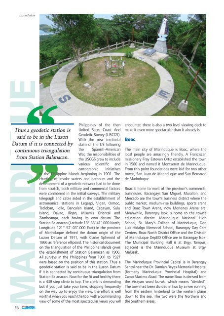
Luzon Datum<br />
Thus a geodetic station is<br />
said to be in the Luzon<br />
Datum if it is connected by<br />
continuous triangulation<br />
from Station Balanacan.<br />
56<br />
Philippines of the then<br />
United Sates Coast And<br />
Geodetic Survey (USCGS).<br />
With the new territorial<br />
claim of the US following<br />
the Spanish-American<br />
War, the responsibilities of<br />
the USCGS grew to include<br />
various scientific and<br />
cartographic initiatives<br />
in the Philippine islands beginning in 1901. The<br />
charting of insular waters and harbours and the<br />
development of a geodetic network had to be done<br />
from scratch, both military and commercial factors<br />
were considered in the initial surveys. The military<br />
telegraph and cable aided in the establishment of<br />
astronomical stations in Legaspi, Vigan, Ormoc,<br />
Tacloban, Iloilo, Bancalan Island, Cagayan, Sulu<br />
Island, Davao, Iligan, Misamis Oriental and<br />
Zamboanga, each having its own datum. The<br />
Station Balanacan (Latitude 13° 33’ 41”.000 North,<br />
Longitude 121° 52’ 03”.000 East) in the province<br />
of Marinduque defined the datum origin of the<br />
Luzon Datum of 1911, with Clarke Spheroid of<br />
1866 as reference ellipsoid. The historical document<br />
on the triangulation of the Philippine islands gives<br />
the establishment of Station Balanacan as 1906.<br />
All surveys in the Philippines from 1901 to 1927<br />
were based on the position of this station. Thus a<br />
geodetic station is said to be in the Luzon Datum<br />
if it is connected by continuous triangulation from<br />
Station Balanacan. Now for the fit and healthy there<br />
is a 439 step climb to top. The climb is demanding<br />
but if you just take your time, stopping frequently<br />
on the way up to enjoy the view, the effort is well<br />
worth it when you reach the top, with a commanding<br />
view of some of the most spectacular views you will<br />
encounter, there is also a two level viewing deck to<br />
make it even more spectacular than it already is.<br />
Boac<br />
The main city of Marinduque is Boac, where the<br />
local people are amazingly friendly. A Franciscan<br />
missionary Fray Estevan Ortiz established the town<br />
in 1580 and named it Montserrat de Marinduque.<br />
From this point foundations were laid for two other<br />
towns, San Juan de Marinduque and San Bernardo<br />
de Marinduque.<br />
Boac is home to most of the province’s commercial<br />
businesses. Barangays San Miguel, Murallon, and<br />
Mercado are the town’s business district where the<br />
public market, medium-rise buildings, sports arena<br />
and Boac Town Arena, now Moriones Arena are.<br />
Meanwhile, Barangay Isok is home to the town’s<br />
education district. Marinduque National High<br />
School, St. Mary’s College of Marinduque, Don<br />
Luis Hidalgo Memorial School, Barangay Day Care<br />
Centers, Boac North District Office and the Division<br />
of Marinduque DepED Office are in Barangay Isok.<br />
The Municipal Building Hall is at Brgy. Tampus,<br />
adjacent is the Marinduque Museum at Brgy.<br />
Malusak.<br />
The Marinduque Provincial Capital is in Barangay<br />
Santol near the Dr. Damian Reyes Memorial Hospital<br />
(formerly Marinduque Provincial Hospital) and<br />
Camp Maximo Abad. The name Boac is derived from<br />
the Visayan word bu-ak, which means “divided”.<br />
The town had been divided in two by a river running<br />
from the eastern hinterland to the western plains<br />
down to the sea. The two were the Northern and<br />
the Southern areas.