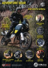
Dirt ad Trail Online Nov 2020

You also want an ePaper? Increase the reach of your titles
YUMPU automatically turns print PDFs into web optimized ePapers that Google loves.
We hurriedly start packing our things. I’m<br />
frantically throwing bike kit and clothing<br />
into bags while Johan carefully goes over<br />
our <strong>ad</strong>venturized KTM 500s to make sure<br />
they are re<strong>ad</strong>y to roll. We also call up our<br />
good friend Dave and the conversation<br />
goes something like this: “Dave, would<br />
you like to join us on a ride in Limpopo?”<br />
“Hmmm, when are we leaving?” “Uh,<br />
tomorrow morning…” “Wait, let me check<br />
with the missus”… A brief moment of<br />
silence ensues and then Dave gets back<br />
to us “OK”. And so without much tactical<br />
precision our plans for the weekend fall<br />
into place.<br />
With the trailers lo<strong>ad</strong>ed and vehicles<br />
packed, we left early on Friday morning<br />
and he<strong>ad</strong>ed north along the N1, eventually<br />
making our way towards Tzaneen and<br />
then past the village of Ofcolaco, reaching<br />
the park in the late afternoon. The staff<br />
sincerely apologized for the phone not<br />
working. The manager jumped into his<br />
cruiser and showed us to our cottages<br />
which were located near an old farmhouse<br />
deep in the reserve. Lekgalameetse translates<br />
to “a place of water” in the Sepedi<br />
language, an apt name for this par<strong>ad</strong>ise.<br />
The mountains here are all a part of the<br />
majestic Drakensberg mountain range,<br />
the park is located amongst rolling grassy<br />
hills, waterfalls, lush valleys, rivers, ponds,<br />
indigenous forests and some of the best<br />
bike trails you’ll ever feast your eyes<br />
upon. As they are also one of the few<br />
nature reserves that actually welcome<br />
bikers with open arms I believe it is of<br />
utmost importance to show respect by<br />
staying on the tracks, being considerate<br />
of noise pollution and generally just not<br />
being arses.<br />
We round off the evening with the fire<br />
roaring and lekker food on the braai.<br />
Tomorrow we will spre<strong>ad</strong> our wings and<br />
touch the sky.<br />
We he<strong>ad</strong> out on the tarred section of the<br />
Orrie Baragwanath pass early on Saturday<br />
morning, the plan is to see some of<br />
the tourist attractions first before he<strong>ad</strong>ing<br />
off to the tough stuff. We are familiar with<br />
the Orrie pass, having ridden it numerous<br />
times before, the route we h<strong>ad</strong> planned<br />
for today we haven’t ridden before. We<br />
overtake a number of surprised cyclists<br />
and pull off the ro<strong>ad</strong> to look at a place<br />
marked as “The Forest Church” on the<br />
GPS, which turns out to be a mysterious<br />
and almost haunting clearing between<br />
the trees. As we climb to the summit of<br />
the pass, the morning mist is so thick we<br />
literally can’t see ahe<strong>ad</strong> of us. We decide<br />
to change our plans and he<strong>ad</strong> through<br />
the forest towards the southern gate of<br />
the reserve first.<br />
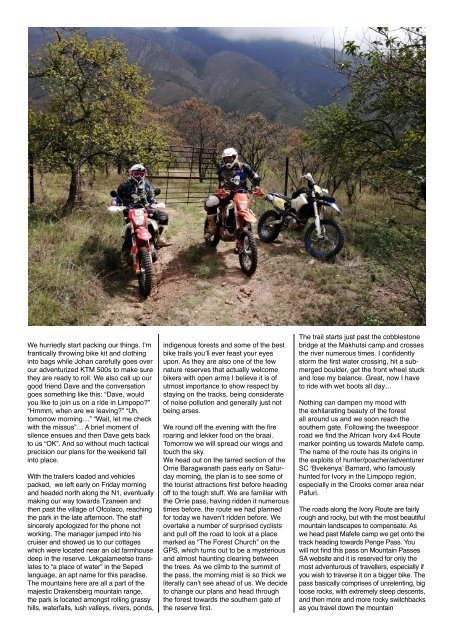
The trail starts just past the cobblestone<br />
bridge at the Makhutsi camp and crosses<br />
the river numerous times. I confidently<br />
storm the first water crossing, hit a submerged<br />
boulder, get the front wheel stuck<br />
and lose my balance. Great, now I have<br />
to ride with wet boots all day…<br />
Nothing can dampen my mood with<br />
the exhilarating beauty of the forest<br />
all around us and we soon reach the<br />
southern gate. Following the tweespoor<br />
ro<strong>ad</strong> we find the African Ivory 4x4 Route<br />
marker pointing us towards Mafefe camp.<br />
The name of the route has its origins in<br />
the exploits of hunter/poacher/<strong>ad</strong>venturer<br />
SC ‘Bvekenya’ Barnard, who famously<br />
hunted for Ivory in the Limpopo region,<br />
especially in the Crooks corner area near<br />
Pafuri.<br />
The ro<strong>ad</strong>s along the Ivory Route are fairly<br />
rough and rocky, but with the most beautiful<br />
mountain landscapes to compensate. As<br />
we he<strong>ad</strong> past Mafefe camp we get onto the<br />
track he<strong>ad</strong>ing towards Penge Pass. You<br />
will not find this pass on Mountain Passes<br />
SA website and it is reserved for only the<br />
most <strong>ad</strong>venturous of travellers, especially if<br />
you wish to traverse it on a bigger bike. The<br />
pass basically comprises of unrelenting, big<br />
loose rocks, with extremely steep descents,<br />
and then more and more rocky switchbacks<br />
as you travel down the mountain<br />
(ridden north to south). As I descend into<br />
the belly of the beast - I shalt have no fear,<br />
for I trust in my 500 to get me through this<br />
rocky monster.<br />
Teeth gritting, butterflies flying rapidly and<br />
that dre<strong>ad</strong>ed rollercoaster feeling in my<br />
stomach I ride down. It feels like the pass<br />
will never end and I keep on reminding<br />
myself to loosen my grip on the handlebars<br />
and just relax. When we finally make<br />
it to the bottom, we stop under a beautiful<br />
tree, part of a fruit orchard of old. I<br />
immediately announce brunch break, and<br />
we sit and eat our energy bars in the cool<br />
sh<strong>ad</strong>e. I’m gl<strong>ad</strong> we took a short break,<br />
as we still h<strong>ad</strong> to cover the last rocky<br />
section of this unrelenting pass before<br />
we reached the bridge over the Olifants<br />
River.<br />
The ro<strong>ad</strong> eventually le<strong>ad</strong>s us to Penge,<br />
an old mining village situated near the<br />
banks of the great Olifants River. There<br />
is a small Total garage here and we grab<br />
something cold to drink from the local<br />
spaza shop. The area was always known<br />
for its Andalusite, gold and platinum mining,<br />
but most of these operations have<br />
come to a standstill in recent years. We<br />
actually pass one of these large opencast<br />
mines on our way. It is apparent that it is<br />
not in use any longer as the ro<strong>ad</strong> next to<br />
the mine is in terrible condition and there<br />
isn’t a soul to be found.<br />
Here we find ourselves riding even more<br />
big boulders, any moment of hesitation<br />
sure to result in a fall. At the end of this<br />
treacherous path we come across a gate<br />
le<strong>ad</strong>ing towards some old mine buildings.<br />
A moment of dre<strong>ad</strong> hits me, what if it’s<br />
locked? We’ll have to retrace our tracks<br />
for quite a distance and time is ticking.<br />
Johan gets off his bike to look - and by<br />
the devil’s own luck the heavy old iron<br />
gate is unlocked and we simply push<br />
it open and we make our way through.<br />
Soon we cross the Olifants River again<br />
following the scenic dirt ro<strong>ad</strong> winding<br />
all along the river past the village of<br />
Ga-Mokgotho where we are met with<br />
waves from curious children and local<br />
people who probably aren’t used to<br />
seeing many motorbikes coming through<br />
the area.<br />
From here on we ascend up another<br />
rocky pass, only slightly less challenging<br />
than the one near Penge we did earlier.<br />
Going up the rocky track leaves no room<br />
for error and I try my best not to stop or<br />
lose momentum. Though these routes<br />
have been traversed on bigger <strong>ad</strong>venture<br />
bikes before, I really do not recommend<br />
tackling these trails unless you are a<br />
VERY experienced rider. We enjoy the<br />
simplicity and lightness of the smaller<br />
<strong>ad</strong>venture bikes on technical terrain,<br />
and also the ease of getting out of sticky<br />
situations.<br />
With a lighter <strong>ad</strong>v bike there is much<br />
more room for error and even if you do<br />
suffer a fall, at least you only have 100kg<br />
falling on your leg, inste<strong>ad</strong> of 200kg<br />
plus. I tried to find the name of this pass<br />
(which forms part of the African Ivory<br />
Route) without success and asked a<br />
fellow <strong>ad</strong>venturer who has travelled the<br />
area before whether he knows the name.<br />
He didn’t, but subsequently dubbed it,<br />
“No-name Pass”, or the “Pass name of<br />
which shall not be spoken”. Is it nearly<br />
as eerie as it sounds, well maybe a little<br />
bit? We stop often for photographs on<br />
our way up, constantly being greeted with<br />
seemingly endless mountains and even<br />
more stunning landscapes.<br />
When we reach the southern Lekgalameetse<br />
Reserve gate again we turn<br />
west, in the opposite direction of the river<br />
ro<strong>ad</strong> we came from in the morning. We<br />
rode under the canopy of the lush green<br />
trees down a fairly overgrown track with a<br />
couple of rocky surprises.<br />
Once we climb up from the canopies of<br />
the trees we ascend the rolling green<br />
hills going towards an area of the reserve<br />
named The Downs. Though the loop I<br />
traced on the GPS only came down to<br />
around 140km, it was by no means a<br />
short day. Most of the terrain kept us<br />
quite busy and there were still a few<br />
challenges left. More unnamed passes<br />
cut into the green hills were ascended<br />
and all of us started to feel we’d worked<br />
quite hard, our concentration levels were<br />
slowly dwindling.<br />
When waiting on a rocky hill Johan was<br />
nowhere to be seen, just when we wanted<br />
to turn around to see if everything is<br />
ok we heard his 500’s motor grumbling<br />
along. Johan h<strong>ad</strong> lost focus on the ro<strong>ad</strong><br />
for just one moment, and nearly went<br />
over the ledge, a rude awakening which<br />
just shows there is no room for error<br />
when exploring remote trails such as<br />
these. After all, no one said climbing the<br />
staircase to heaven would be easy and<br />
we carefully navigated some of the last<br />
remaining obstacles on our path.<br />
Near the end of our route we stop at<br />
the ruins of “Orrie’s” son, Paul Baragwanath’s<br />
homeste<strong>ad</strong> and ruminated at<br />
how amazing it must have been living in<br />
this glamorous Garden of Eden. We also<br />
visited the Baragwanath family burial site<br />
located on top of a hill near the summit of<br />
the Orrie Baragwanath Pass.<br />
Mr Orlando “Orrie” Baragwanath m<strong>ad</strong>e<br />
his riches prospecting in Rhodesia and<br />
Zambia where he was known as the Copper<br />
King. Upon his return he settled down<br />
and farmed in the part of Lekgalameetse<br />
known as The Downs, where he built<br />
most of the ro<strong>ad</strong>s, the well-known Orrie<br />
Baragwanath pass being named in his<br />
honour. Mr Baragwanath lived in the area<br />
until he passed away at the ripe old age<br />
of 101 in 1973.