Times of the Islands Winter 2020/21
Presents the "soul of the Turks & Caicos Islands" with in-depth features about local people, culture, history, environment, real estate, businesses, resorts, restaurants and activities.
Presents the "soul of the Turks & Caicos Islands" with in-depth features about local people, culture, history, environment, real estate, businesses, resorts, restaurants and activities.

You also want an ePaper? Increase the reach of your titles
YUMPU automatically turns print PDFs into web optimized ePapers that Google loves.
green pages newsletter <strong>of</strong> <strong>the</strong> department <strong>of</strong> environment & coastal resources<br />
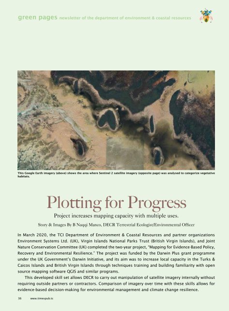
This Google Earth imagery (above) shows <strong>the</strong> area where Sentinel 2 satellite imagery (opposite page) was analysed to categorize vegetative<br />
habitats.<br />
Plotting for Progress<br />
Project increases mapping capacity with multiple uses.<br />
Story & Images By B Naqqi Manco, DECR Terrestrial Ecologist/Environmental Officer<br />
In March <strong>2020</strong>, <strong>the</strong> TCI Department <strong>of</strong> Environment & Coastal Resources and partner organizations<br />
Environment Systems Ltd. (UK), Virgin <strong>Islands</strong> National Parks Trust (British Virgin <strong>Islands</strong>), and Joint<br />
Nature Conservation Committee (UK) completed <strong>the</strong> two-year project, “Mapping for Evidence-Based Policy,<br />
Recovery and Environmental Resilience.” The project was funded by <strong>the</strong> Darwin Plus grant programme<br />
under <strong>the</strong> UK Government’s Darwin Initiative, and its aim was to increase local capacity in <strong>the</strong> Turks &<br />
Caicos <strong>Islands</strong> and British Virgin <strong>Islands</strong> through techniques training and building familiarity with open<br />
source mapping s<strong>of</strong>tware QGIS and similar programs.<br />
This developed skill set allows DECR to carry out manipulation <strong>of</strong> satellite imagery internally without<br />
requiring outside partners or contractors. Comparison <strong>of</strong> imagery over time with <strong>the</strong>se skills allows for<br />
evidence-based decision-making for environmental management and climate change resilience.<br />
36 www.timespub.tc