proposition 2

You also want an ePaper? Increase the reach of your titles
YUMPU automatically turns print PDFs into web optimized ePapers that Google loves.
PROPOSITION 2
Considering that the daily reality and its
spatial context are mutually depended,
people organizing and shaping our spatial
environment and people concerning with
how people live and understand in those
environments could benefit from one
another.
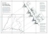
areas:
Vast Steppe
A steppe is grassland plains without trees It rains enough for grass
to grow but not enough for trees. The view reaches kilometers and
kilometers far and nothing is else to see than grass. It is an isolated
place remote from any context. The stations in the Vast Steppe are
about distance and being remote from the place at hand.
Canyon of Trying
A canyon is a deep cleft between cliffs resulting from the erosive
activity of a river over geologic time scales. A canyon is characterized
by its steep cliffs and the difficulties to cross to the other side of
what the river cut away. The Canyon of Trying is a place where the
insurmountable bridging is nevertheless made and one tries to get
closer by descending into the deep grooves and fissures.
Ridge of Scenery - Ridge of Accompaniment
Ridges consist of a chain of mountains that form a continuous
elevated crest for an extended distance. The sides of the ridge slope
away from the narrow top on either side. Experienced runners like
to run on ridges. The smaller the better. The two Ridges of Scenery
and Accompaniment allow, in-between them, a valley where it is
impossible to overlook them.
routes:
local loop
point to point
PLACE DE L’EGLISE:
EVERYTHING TAKES PLACE
In the summer of 2021 I visited Chamonix-
Mont-Blanc in France. (1) After a long run I had a
drink at a bakery at Place de l’église. It is a rather
cluttered square without a clear geometric shape,
with old and much used grey -and beige-like tiles
as pavement. Other people are walking around and
are ordering a drink as well. At the end, it is difficult
to imagine the square excluding people. The one
does not exist without the other, it seems. Even if
the square is empty, late in the middle of the night
for example, the municipality and its urban planners
took care of how the square is designed. People
working for the facility department clean and maintain
it. Policymakers responsible for safety and mobility
care about where to walk to cross the square, where
to cycle and where terraces are located. The café
-and bakery owners take care of their terraces and
clean them daily, the inhabitants living above the
cafés and the tourist visiting the hotels keep an eye
on the square when. The square is made, used and
taken care of by people.
Two other people now are searching for
a comfortable place on one of the terraces. The
covid-19 pandemic makes them wearing mouth
masks but other than that Place de l’église is a quiet
but lively little square where tourists can enjoy the
omnipresent mountains without any concerns. Both
of them are ordering drinks. What could be a good
motive why they are meeting here and having a
drink? I try to come up with reasons. Is it close to
home? Or in the middle between two destinations?
Is it because they like the place and have good
memories of that local bakery? Or is it because they
have a good view on the square and mountains from
the terrace? What do they want do discuss? Are
they friends, colleagues or family? Maybe all those
assumptions are possible, and I can imagine plenty
more motivations for picking exactly that spot. But
that is not the point I would like to make. The square,
the bakery and the terraces indicate that, in every
respect, each of the above reasons summed up
explains that even a habitual thing like two persons
having a drink, cannot be seen without its spatial
context. Everything takes place.
In the middle of the Place de l’église and also
close to the Tourist Information Center, a display with
maps is installed to help the tourists to orientate. Even
since google maps, and other navigation devices,
were installed on the first smartphones back in 2007
those maps often seem to be updated and of use for
the unfamiliar user of the square, the town in general
and to recognize the peaks of the Mont-Blanc-
Massif surrounding the square. Sometimes, these
types of maps point out where you are and how far
you are away from places the mapmaker considered
as valuable to add to the map. Information as the
train station of the SNCF, the train station to goi into
the mountains to Mer de Glace, parking lots, public
toilets, musea, and the Tourist Information Center
itself are on the map in the case of the Place de
l’église. A specific selection of information is shared
with the tourist. And even though such maps can
contain a rich collection of cultural, practical and
consumer-orientation information, a lot has been left
behind too. Inevitable for the mapmaker to make the
map easy and straightforward to read and interpret.
The map on Place de l’église is made from a
different point of view than the maps spatial designers
use for example. (2) But their purpose might be the
same. Namely, to get a better understanding of the
square and its environment. They contain lines for
streets or buildings. Or a line to where a landowner
can build a house, or lines that indicate special
construction concerns like for example, unstable
ground. Coloured surfaces are used to indicate
areas with architectural and heritage quality, natural
or historical quality or risk of inundation etc. Street
-and place names and other pieces of text, a legend
and a North arrow are also part of such maps. But,
the map does not contain the two people searching
their way and having a drink. The map disregards
all the possible reasons summed up earlier why
the two choose exactly that spot on the Place de
l’église. All the sudden, the map only indicates the
spatial, materialised parts and tends to dismiss
the people making -and using the square. Daily life
does not seem to take part on the map. Where did
that part go? Is someone taking care of it? Who is
interested in daily life realities? Someone with an
anthropological orientation would take place on
the square and observe, participate, bring themself
among the people and tries to gain experiences
there themselves, explore the surrounding, its use
and has informal conversations with the two people
searching the way or having a drink for example. (3)
They would take their notebook and intensively try
to describe what happens. They write, a lot. And
sometimes, among other documentation, a little
sketch accompanies their words. (4) These words
mostly demand to get acquainted with the field in
a linear way as you habitually start on the top left
and end on the bottom right of a page. Back to
the map of the square, where to start reading it?
Where do you end? Which part takes more time
to understand? Maps are made according to a
different set of conventions as writing such as
scales, annotation, the use of different line types
-and weight and geographical ordering. Drawing
(maps) is commonly used as a tool for thought and
investigation like diagrams or the little sketches in
a notebook. Besides scale and proportion maps
also allow to explain and navigate a way through the
world, or in this case through the Place de l’église
and the whole Mont-Blanc-Massif.
I wonder, why can’t we have both? If the
two people on the Place de l’église determine very
precisely how and where they sit on the terrace and
how they behave on the square and if exactly that
terrace is the most popular location on the square,
how is it possible disciplines and especially skills that
have so much to do with each other do not speak,
use, benefit from and invest in a common language?
How come an anthropologist doesn’t make maps and
a spatial designer lacks anthropological fieldwork
tools? Apart from the fact that both perspectives
can teach each other a great deal, it is also of added
value to the daily life of the place and the place itself
if both perspectives are taken into consideration.
Because, what actually happens when Place de
l’église is in need of renovation or reconstruction?
Roughly every 30 till 50 year public squares
get renovated, depending on legislation and budget
restriction of the town they are part of. Spatial
designers from the municipality often in collaboration
with an architecture -or urban planning office work
on a future design for it. They visit the location
a couple of times but are quickly focusing on the
future design for the square. They have been taking
in account different studies such as the technical
possibilities and historical analysis of it. Maps are
drawn and plans are made. Meetings between the
spatial designer and the urban planners, architects
and engineers of the municipality take place around
them.(5) Community builders, street coaches
and other people working within institutions and
programs close to the daily reality of the square are
rarely involved as intense as people with a spatial
point of view. Not only is the time spent on location
only a little percentage of the total time of investment
in, and impact on, the project; situated knowledge
and the basic daily life on this square are not involved
equally. The maps in the middle of the table need
rapprochement and the people around it need to
adopt each other’s skills to fill in the gap between
social policy (‘ridge of Accompaniment’ on the
panoramic view), spatial policy (‘ridge of Scenery’
on the panoramic view) and the actual square itself.
The maps and the location represented on
the maps, like the square, suffer under the duality
between social and spatial thinking, but another
facture (‘Canyon of Trying’ on the panoramic view)
also challenges the square as well. As spatial
designers took in account studies and analyses
of the square, the social department responsible
for the square also have been making studies and
reports often executed without being at the square,
remotely, in concept and rather abstract. But the
situated, embodied, contextualized and often
invisible knowledge about the why and how the two
people find their place on the terrace is to be gained
at and from the square itself. The small, local and
intimate that anthropological fieldwork makes visible
is often lost sight of and even less often represented
on maps that serve as a foundation for the spatial
renovation of, in this case, the square.
When visiting Chamonix in the summer of
2021 I must admit that I tried to imagine how it would
be to live on the Place de l’église, with a view on the
cafés and impressive Mont-Blanc-Massif.(6) How
would it be to use the square daily? Would I get sick
of all the tourist, like me last summer? On the other
hand, I would know the best place to spot the sun
on a bright winter day. I would know how and why
each Wednesday in the afternoon traffic get stuck,
for example. And I would know why that café in the
corner changes owner regularly. As an inhabitant, I
would know that because I am part of the square.
I reposition myself again and try to imagine
working as a policy maker for the municipality
Chamonix-Mont-Blanc, in the spatial or social field,
remotely and in theory about the square.(7) Then
my colleagues will maybe know that the Christmas
tree will be put in the middle of the square and that
the finish line of the famous Ultra Trail Mont Blanc
is right at the beginning of the square in front of the
townhall, for example. They will know all the safety
measurements to take to be able to welcome all
the tourists. They will know that the number of cars
passing by yearly is little and the historical value of
the façade of the café in the corner. They will use
maps to mark the place of the Christmas tree or
the finish line. They will measure if the space left is
enough for fire men to pass by in case of emergency
and discuss it with companies placing the Christmas
tree or the finish line. They might think of a heritage
status for the café in the corner of the place. But the
knowledge I have as an inhabitant will stay mostly
unseen. But they will not take in account that the
Christmas tree will put shadow on the best spots of
the terrace on a sunny winter day for example. Or,
safety measures are taken but there are not enough
public toilets so the corner in the back of the square
has been assigned as an informal toilet by tourists.
What if these aspects are also mapped and taken
in account? What if we could know both, from a
situated point of view and from a more abstract
point of view? What if we would bridge the fracture
between social and spatial perspective by changing
position and distances according to the square.
What would that do to the future of the square?
The evening spatial designers organize
for inhabitants to participate comes close to a
nightmare. The plans and maps of the future design
are ready. Printed in multiple copies and placed on
different tables in a local community center where
the participation evening takes place. Also on the
table are often post-it in various colors and thick
pens. Like the map on the Place de l’église, the plans
and maps on the tables are simplified. To make them
straightforward and easier to read. The evening
starts with a presentation on how the design is built
up and why certain choices are made. Sometimes
the spatial designers will add a historical summary.
(8) In the room, some people (most of the time there
are fewer people participating than expected) start
becoming nervous and moving around on their chairs.
They have decided, already before they entered the
room to be against the project. Confidence is low.
‘Why would we believe what they say, they never do
what they promise.’ One of the participants says.
From inhabitants is expected they think as a spatial
designers, fuelled with specific and design related
knowledge. De café -and bakery owner at Place de
l’église are both expected to be able to read those
technical maps and issues. However, their expertise
lies in the intimate, situated knowledge about the
square. It is a pity that the spatial designers have
not learned to take that in account and that social
departments are rarely present on those evenings.
(9) The evening only just started, the post-its are
still unused and I already feel sorry for the square. I
believe that maps and plans that join perspectives,
made from a situated point of view overcome the
above misunderstandings and gather all possible
knowledge our local environment consist of.
1 Place de l’église in Chamonix-Mont-Blanc is a square in
the middle of the city center, situated in front of the church
Saint-Michel. The church was built in 1709 in a baroc style
adapted to the alpine conditions (art baroque Savoyart).
Besides the church and as Chamonix-Mont-Blanc is a known
place in alpinism, the square is surrounded with the ‘Office de
Tourisme de Chamonix-Mont-Blanc’ several hotels and cafés
are part of the square and also the townhall is located at the
Place de l’église. Besides the buildings and the daily activities
on the square that attracts your attention there is the constant
presence of the impressive Mont-Blanc-Massive peaks in the
background.
2 Already during my studies at various faculties of
Architecture, working in architectural offices afterwards and
as a cartopologist for various governmental institutions cards
turned up in all these places. Conversations were held around
those maps, about specific locations on the map. Sometimes
local and specific, sometimes broad, and general, but always
with the aim of making the location on the map better.
3 Through this research project and my artistic research
practice I often encounter anthropologists. For example, I
collaborate with them at Maastricht University, or via a project
assignment for the University of Amsterdam I came into
contact with the cultural anthropology department, or through
workshops and lecture series I set up together with the cultural
anthropology department of Leiden University. In addition,
in presentations about my own practice cartopological maps
appeal to the imagination and are far removed from the usual.
4 Anthropology is a science and a university discipline.
Worldwide, science is mainly excecuted and shared in
sentences and words. The same goes for anthropology. There
are of course exceptions such as visual ethnography that is
taught in Leiden University for example, but language still
plays a large part. Reading a text or reading a map implies a
different approach. Where eyes are guided, for example in an
English paper, from left to right, from line to line, those same
eyes will wander on a map. Sometimes stopping to focus on a
detail to zoom out again for an overview.
5 Working for architectural offices until 2015 and being
active as a cartopologist ever since I have participated in those
meetings from different perspectives.
6 During that summer my partner and I stayed for a couple of
nights at the Hotel ‘La Croix Blanche’ with a view over Place
de l’église.
7 With Dear Hunter I worked for French governmental
institutions in the summer of 2019 in Saint-Omer, France. It
gave me a little glimpse in how French public institution are
organized. It helps me to imagine how it must me at Chamonix.
8 I have witnessed this scenery a couple of times from
different perspectives. Often while doing fieldwork. In that case
I take part as an inhabitant. Lately I attended such a meeting
in the neighborhood Moerwijk, The Hague where people from
several departments from the municipality took the stage and
explained the future plans of the neighborhood. But also in
Valkenburg aan de Geul, Heerlen, Maastricht and Herstal I
witnessed such a participation evenings.
9 For Dear Hunter I was present at an evening organised
for inhabitants of the neighourhood Krottegem in the city of
Roeselare. During that evening the ‘community budget’ was
explained by an external company and civel servant from
the department ‘Neighbourhood and Participation (wijken
en participatie). A budget of € 400.000 is assigned for local
initiatives in the public space of the neighbourhood Krottegem.
Not one person from the spatial department was present
that evening. Another example of how social and spatial
departments are working separately, however impact the same
spot and location in a city or village.