proposition 2

Create successful ePaper yourself
Turn your PDF publications into a flip-book with our unique Google optimized e-Paper software.
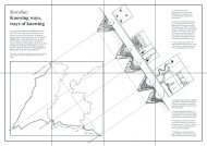
scales, annotation, the use of different line types
-and weight and geographical ordering. Drawing
(maps) is commonly used as a tool for thought and
investigation like diagrams or the little sketches in
a notebook. Besides scale and proportion maps
also allow to explain and navigate a way through the
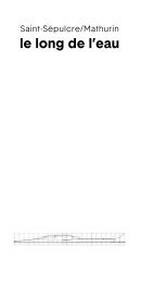
world, or in this case through the Place de l’église
and the whole Mont-Blanc-Massif.
I wonder, why can’t we have both? If the
two people on the Place de l’église determine very
precisely how and where they sit on the terrace and
how they behave on the square and if exactly that
terrace is the most popular location on the square,
how is it possible disciplines and especially skills that
have so much to do with each other do not speak,
use, benefit from and invest in a common language?
How come an anthropologist doesn’t make maps and
a spatial designer lacks anthropological fieldwork
tools? Apart from the fact that both perspectives
can teach each other a great deal, it is also of added
value to the daily life of the place and the place itself
if both perspectives are taken into consideration.
Because, what actually happens when Place de
l’église is in need of renovation or reconstruction?
Roughly every 30 till 50 year public squares
get renovated, depending on legislation and budget