
Create successful ePaper yourself
Turn your PDF publications into a flip-book with our unique Google optimized e-Paper software.
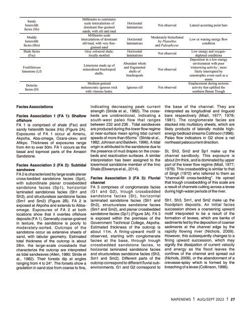
Sandy<br />
heterolith<br />
facies (Hs)<br />
Muddy<br />
heterolith<br />
facies (Hm)<br />
Shale facies<br />
(Fsc)<br />
Fosiliferrous<br />
limestone (Lf)<br />
Dolerite<br />
facies (D)<br />
Millimetre to centimetre<br />
scale intercalations of<br />
dominant fine-grained<br />
sands, with silt and mud<br />
Millimetre scale<br />
intercalations of dominant<br />
silt/mud, with very finegrained<br />
sand<br />
Grey coloured shale;<br />
locally mottled<br />
Limestone made up of<br />
mineralized brachiopod<br />
shells.<br />
Medium-grained<br />
melanocratic igneous rock<br />
with vitreous lustre.<br />
Horizontal<br />
laminations<br />
Horizontal<br />
laminations<br />
Horizontal<br />
laminations<br />
Abundant whole<br />
and fragmented<br />
shells of<br />
brachiopods<br />
Igneous sill<br />
Not observed<br />
Moderately bioturbated<br />
by Planolites<br />
and Paleophycus<br />
Not observed<br />
Not observed<br />
Not observed<br />
Lateral accreting point bars<br />
Low or waning energy flow<br />
condition<br />
Low energy and oxygendepleted<br />
conditions<br />
Deposition in a low-energy<br />
environment with poor<br />
winnowing activity ; most<br />
likely interrupted by<br />
catastrophic event such as a<br />
storm<br />
Emplacement during tectonic<br />
activity that uplifted the<br />
southern Benue Trough<br />
Facies Associations<br />
Facies Association 1 (FA 1): Shallow<br />
offshore<br />
FA 1 is comprised of shale (Fsc) and<br />
sandy heterolith facies (Hs) (Figure 2A).<br />
Exposures of FA 1 occur at Amenu,<br />
Akpoha, Aba-omege, Ozara-ukwu and<br />
Afikpo. Thickness of exposures range<br />
from 4m to over 50m. FA 1 occurs as the<br />
basal and topmost parts of the Amasiri<br />
Sandstone.<br />
Facies Association 2 (FA 2): Subtidal<br />
sandwave<br />
FA 2 is characterized by large scale planar<br />
cross-bedded sandstone facies (Sp4),<br />
with subordinate planar crossbedded<br />
sandstone facies (Sp1), horizontal<br />
laminated sandstones facies (Sh1 and<br />
Sh3), and structureless sandstone facies<br />
(Sm1 and Sm2) (Figure 2B). FA 2 is<br />
exposed at Akpoha and extends to Abbaomege.<br />
Exposures of FA 2 at both<br />
locations show that it overlies offshore<br />
deposits (FA 1). Generally coarse-grained<br />
in texture, the sandstone is poorly to<br />
moderately-sorted. Outcrops of the<br />
sandstone occur as extensive sheets of<br />
sand, with tabular geometry. Estimated<br />
total thickness of the outcrop is about<br />
28m. the large-scale crossbeds that<br />
characterize the outcrop are interpreted<br />
as tidal sandwaves (Allen, 1980; Stride et<br />
al., 1982). Their forests dip at angles<br />
ranging from 4 to 24°. The forsets show a<br />
gradation in sand size from coarse to fine,<br />
indicating decreasing peak current<br />
strength (Stride et al., 1982). The crossbeds<br />
are unidirectional, indicating a<br />
south-west paleo flow that ranges<br />
between 232 and 236 . Tidal sandwaves<br />
are produced during the lower flow regime<br />
at near-surface mean spring tidal current<br />
-1<br />
speeds of more than 65cms (Stride et al.,<br />
1982; Johnson and Baldwin, 1996). A tidal<br />
origin is attributed to the sandstone due to<br />
the presence of mud drapes on the crossbeds<br />
and reactivation surfaces. A similar<br />
interpretation has been assigned to the<br />
lowermost sandstone member of the Imo<br />
Shale (Ekwenye et al., 2014).<br />
Facies Association 3 (FA 3): Fluvial<br />
channel<br />
FA 3 comprises of conglomerate facies<br />
(G1 and G2), trough crossbedded<br />
sandstone facies (St), horizontal<br />
laminated sandstone facies (Sh1 and<br />
Sh3), structureless sandstone facies<br />
(Sm1 and Sm2), and planar crossbedded<br />
sandstone facies (Sp1) (Figure 3A). FA 3<br />
is exposed within the premises of the<br />
Government Technical College, Akpoha.<br />
Estimated thickness of the outcrop is<br />
about 11m. A fining-upward motif is<br />
observed, starting with conglomerate<br />
facies at the base, through trough<br />
crossbedded sandstone facies, to<br />
horizontal laminated sandstone facies<br />
and structureless sandstone facies (Sh3,<br />
Sm1 and Sm2). Different parts of the<br />
outcrop correspond to different fluvial subenvironments.<br />
G1 and G2 correspond to<br />
the base of the channel. They are<br />
interpreted as longitudinal and linguoid<br />
bars respectively (Miall, 1977; 1978;<br />
1981). The conglomerate facies are<br />
stacked into multistory sheets, which are<br />
likely products of laterally mobile highenergy<br />
bedload streams Collinson (1996).<br />
Paleo flow indicators in G2 show a net<br />
northeast paleocurrent direction.<br />
St, Sh3, Sm2 and Sp1 make up the<br />
channel sandbody. This exposure is<br />
about 2m thick, and is dominated by upper<br />
part of the lower flow regime (Miall, 1977;<br />
1978). This crossbedding is similar to that<br />
of Singh (1972) who referred to them as<br />
“channel-fill cross-bedding”. He opined<br />
that trough crossbedding of this scale are<br />
a result of channels cutting across a levee<br />
during high-water periods of the river.<br />
Sh1, Sh3, Sm1, and Sm2 make up the<br />
floodplain deposits. An initial facies<br />
succession shows a coarsening upward<br />
motif interpreted to be a result of the<br />
formation of levees, which are banks of<br />
sediments fed by the deposition of coarser<br />
sediments at the channel edge by the<br />
rapidly flowing river (Nichols, 2009).<br />
However, this subsequently changes to a<br />
fining upward succession, which may<br />
signify the dissipation of current velocity<br />
and energy as the flood leaves the<br />
confines of the channel and spread out<br />
(Nichols, 2009), or the abandonment of a<br />
crevasse-splay which is formed by the<br />
breaching of a levee (Collinson, 1996).<br />
NAPENEWS AUG/SEPT <strong>2022</strong> 27