Pittwater Life January 2024 Issue
LOCAL GUIDE: 193 THINGS TO DO 1991‘DEVELOPMENT ONSLAUGHT’ FEARS / BEACHES ACHIEVERS HOLIDAY CROSSWORD + PUZZLES / BARRENJOEY BOATSHED THE WAY WE WERE / HOT PROPERTY / SEEN... HEARD... ABSURD...
LOCAL GUIDE: 193 THINGS TO DO
1991‘DEVELOPMENT ONSLAUGHT’ FEARS / BEACHES ACHIEVERS
HOLIDAY CROSSWORD + PUZZLES / BARRENJOEY BOATSHED
THE WAY WE WERE / HOT PROPERTY / SEEN... HEARD... ABSURD...

Create successful ePaper yourself
Turn your PDF publications into a flip-book with our unique Google optimized e-Paper software.
Summer Guide<br />
Rock Platforms<br />
When the tide retreats a secret<br />
world of marine ecosystems<br />
opens up with clusters of<br />
mini aquariums, teeming<br />
with tiny creatures. Explore<br />
the flat, expansive, eroded<br />
regions at the bottom of<br />
our rocky headlands. You’ll<br />
find they’re home to a huge<br />
variety of plants, animals and<br />
invertebrates such as starfish,<br />
crabs and shellfish. Locals’ Tip:<br />
Visit the Coastal Environment<br />
Centre at Narrabeen to learn<br />
more about our rocky shores.<br />
Warriewood Wetlands<br />
Covering 26 hectares<br />
Warriewood Wetlands is the<br />
largest remaining sand plain<br />
wetland in northern Sydney.<br />
There’s a boardwalk stretching<br />
2.4km and trails that can lead<br />
you to waterfalls (see below).<br />
You can take a self-guided tour<br />
starting from Katoa Close by<br />
following the new signs and<br />
scanning the QR codes to learn<br />
about the plants and animals<br />
and history that make up this<br />
area. The wetlands are easy to<br />
find (just behind Warriewood<br />
Square) and it’s an easy walk<br />
that will take you 45 minutes to<br />
an hour.<br />
Irrawong Waterfall<br />
The track to the waterfall is<br />
accessible from Garden Street<br />
or the end of Irrawong Road,<br />
corner of Epworth Avenue<br />
Warriewood. It takes about<br />
20 minutes from the Garden<br />
Street entrance and is relatively<br />
manageable by most fitness<br />
levels as much of the walk<br />
is quite flat along cleared<br />
paths or wooden boardwalks.<br />
However, there are steps in<br />
sections, so not suitable for<br />
wheelchairs or strollers. You<br />
will see lots of rainforest<br />
and if you are lucky, local<br />
wildlife. The waterfall clearing<br />
is a popular picnic spot, but<br />
the size of the clearing (and the<br />
6m waterfall flow) depends on<br />
recent rainfall. It can also be a<br />
little muddy. There are tracks<br />
beyond the waterfall but be<br />
careful as the track is steep.<br />
Narrabeen Lagoon<br />
State Park<br />
Step out and walk, enjoy<br />
numerous water sports, or<br />
simply find a spot to relax<br />
near the water’s edge. There<br />
is an 8.6-kilometre trail with<br />
no inclines around the lagoon,<br />
which will take you 2-3 hours<br />
on foot if you want to enjoy<br />
the beautiful ecosystems,<br />
cultural heritage and historical<br />
sites. The well-formed track<br />
is a shared trail popular with<br />
joggers, hikers, cyclists, dogs<br />
on leads, mums with prams,<br />
and bike riders. Cyclists are<br />
asked to stick to the left and<br />
pedestrians have right of way.<br />
There are places to peel off<br />
to rest, and picnic areas with<br />
toilet facilities dotted along<br />
the circuit. If you don’t want to<br />
tackle the loop in one go, there<br />
are five short walk options<br />
(Middle Creek to Bilarong<br />
Reserve – 2.2km; Bilarong<br />
Reserve to Berry Reserve –<br />
1.2km; Jamieson Park to South<br />
Creek – 2.3km and South Creek<br />
to Middle Creek – 1.2km).<br />
Angophora Reserve<br />
Located in the suburbs of<br />
Avalon Beach and Clareville,<br />
this 18.5-hectare space<br />
provides a small taste of the<br />
peninsula similar to what<br />
it was like pre-settlement<br />
with significant samples of<br />
vegetation and fauna habitats<br />
that are under threat. The<br />
reserve was intended to<br />
preserve a giant Angophora<br />
tree. It also contains one of<br />
the most archaeologically<br />
significant Aboriginal shelter<br />
sites in the Sydney region.<br />
Two main walking tracks<br />
extend through the reserve,<br />
one from the Palmgrove Road<br />
to Wandeen Road entrances<br />
and one from Hilltop Road to<br />
Chisholm Avenue.<br />
WALK THIS WAY<br />
From challenging hikes for<br />
you to sink your boots into,<br />
boardwalks signposted for selfguided<br />
tours and gentle strolls<br />
along well-formed paths, here<br />
are just a few of the walks you<br />
can take to make the best of<br />
our great outdoors. Some can<br />
be found close to home, others<br />
a little further afield. You can<br />
discover many more walks and<br />
more details on the AllTrails<br />
app, at nationalparks.nsw.gov.<br />
au and Council website. Locals’<br />
Tip: Protect yourself from<br />
ticks and mozzie bites – warm,<br />
wet weather means more are<br />
breeding and biting, including<br />
the ones that can carry disease.<br />
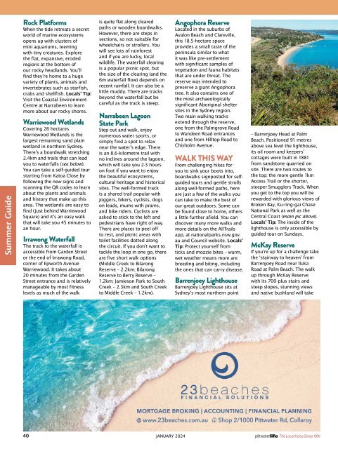
Barrenjoey Lighthouse<br />
Barrenjoey Lighthouse sits at<br />
Sydney’s most northern point<br />
– Barrenjoey Head at Palm<br />
Beach. Positioned 91 metres<br />
above sea level the lighthouse,<br />
its oil room and keepers’<br />
cottages were built in 1881<br />
from sandstone quarried on<br />
site. There are two routes to<br />
the top; the more gentle 1km<br />
Access Trail or the shorter,<br />
steeper Smugglers Track. When<br />
you get to the top you will be<br />
rewarded with glorious views of<br />
Broken Bay, Ku-ring-gai Chase<br />
National Park as well as the<br />
Central Coast (main pic above).<br />
Locals’ Tip: The inside of the<br />
lighthouse is only accessible by<br />
guided tour on Sundays.<br />
McKay Reserve<br />
If you’re up for a challenge take<br />
the ‘stairway to heaven’ from<br />
Barrenjoey Road near Iluka<br />
Road at Palm Beach. The walk<br />
up through McKay Reserve<br />
with its 700-plus stairs and<br />
steep slopes, stunning views<br />
and native bushland will take<br />
40 JANUARY <strong>2024</strong><br />
The Local Voice Since 1991