Create successful ePaper yourself
Turn your PDF publications into a flip-book with our unique Google optimized e-Paper software.
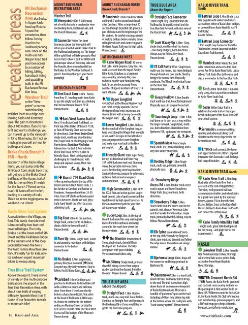
Mt Buchanan<br />
Recreation<br />
Area aka Bucky.<br />
In Upper <strong>Kaslo</strong><br />
head up Victoria<br />
St past the<br />
cemeteries, then<br />
follow Zwicky<br />
Road to the<br />
Trailhead parking<br />
area. Once on the<br />
multi-use K&S<br />
Wagon Road Trail<br />
you have access<br />
to a number of<br />
hiking, biking,<br />
horseback riding<br />
and quadding<br />
trails in the Mt<br />
Buchanan Recreation<br />
Area.<br />
Wardner Trail<br />
or the “Viewpoint”:<br />
a narrow<br />
switchbacking<br />
trail that leads to a ridge overlooking<br />
<strong>Kaslo</strong> and Kootenay<br />
Lake. The gain in elevation is<br />
about 100 metres. If you’re really<br />
fit and want a challenge, you<br />
can make it up to the viewpoint<br />
in 15 to 18 minutes. Or if not so<br />
much, give yourself an hour for<br />
both up and down.<br />
Brake Check/Branch 7<br />
FSR – North<br />
Just north of the <strong>Kaslo</strong> village<br />
limits, you can jump onto the<br />
Jimi Crack Corn single track that<br />
will get you to the Brake Check<br />
trail head of the Access trail. A<br />
little further on Hwy 31 watch<br />
for the Branch 7 Forest service<br />
road – it takes off on the left,<br />
leading to a variety of trails.<br />
This is an active logging area, so<br />
weekend use is best.<br />
recreation areas<br />
<strong>Kaslo</strong> River Trail System<br />
Accessible from the Village, on<br />
foot. This lovely riverside stroll<br />
is bracketed by two beet-red<br />
covered bridges. The Unity<br />
Bridge is at the lower end of 5th<br />
Street and the Trailblazer Bridge<br />
at the western end of the loop.<br />
Located between the two is<br />
the <strong>Kaslo</strong> Family Mountain Bike<br />
Park. It’s really fun for kids, novice<br />
and even expert mountain<br />
bikers to swoop along.<br />
True Blue Trail System<br />
Above the airport. There is a lot<br />
of variety on the multi-purpose<br />
trails above the airport in the<br />
True Blue Recreation Area, with<br />
about nine trails of varying<br />
difficulty. Spanish Moss (trail 9)<br />
is one of our favourites to walk<br />
or mountain bike!<br />
16 <strong>Kaslo</strong> and Area<br />
MOUNT BUCHANAN<br />
RECREATION AREA<br />
Wardner Trail<br />
Viewpoint 400m A fairly steep<br />
set of switchbacks to a spectacular view<br />
overlooking <strong>Kaslo</strong>, Kootenay Lake, and<br />
the Purcell Mountains.<br />
Connector 500m The short<br />
Connector above the Viewpoint will<br />
return you downhill via No Brakes trail to<br />
the Trailhead and parking lot. The longer<br />
600m uphill trail will take you up to West<br />
Access Trail. Follow it east for 800m with<br />
picturesque views of Kootenay Lake and<br />
the Purcells, then return downhill on<br />
No Brakes to the Wardner Trailhead. A<br />
great 1 hour loop that gets your heart<br />
pumping!<br />
MT BUCHANAN NORTH<br />
Jimi Crack Corn 1.4km - Access<br />
from Hwy 31, heading north from <strong>Kaslo</strong><br />
to use the single track trail as a climbing<br />
trail to head toward Branch 7 FSR.<br />
Unsanctioned.<br />
/♦East/West Access Trail Off<br />
Hwy 31 via Brake Check Trail Head, or<br />
from top of No Brakes off Branch 7 FSR,<br />
or East off Friendly Giant intersection,<br />
bi-directional. Start from Brake Check<br />
single track, multi-use bike climbing<br />
trail, loops back on challenging xc and<br />
flowy down. Start from No Brakes<br />
Intersection: Go East 2.3km to Brake<br />
Check Trail Head, or West 6.7km to<br />
Friendly Giant. West side is physically<br />
challenging to Friendly Giant with<br />
steep and exposed slopes. Most ride<br />
East to West.<br />
/♦ Branch 7 FS Road Climb<br />
4.4km gravel road up to the top of No<br />
Brakes and East/West Access Trails, 1.5<br />
km further to Carlsbad and further to<br />
Pandemic. Average climb time: 35-50<br />
mins. Four stiff climbs with some good<br />
rests in between. Multi-use trail, physically<br />
hard. Worth the effort to access<br />
adjoining trails.<br />
Big Foot 500m At the junction,<br />
Single track, connector to No Brakes...<br />
climb a little further on Branch 7.<br />
Unsanctioned.<br />
Turn Up 900m. Single track, winds<br />
in and around a rock ridge, with bridges<br />
connector to No Brakes.<br />
Unsanctioned<br />
No Brakes 1.7km Single track,<br />
primary direction: downhill. (♦Climb)<br />
Can push up, physically extreme. Easy to<br />
follow. Fast & flowy down.<br />
♦Carlsbad 1.4km Continue past<br />
junction to No Brakes, Carlsbad takes off<br />
with a climb to a bench and delicious<br />
view. From there it levels out shortly<br />
before a sharp steep decent. You arrive<br />
at the head of No Brakes. A little ways<br />
in, choose to continue to the bottom<br />
ending on Wardner Street or take the<br />
East Access Trail (to Brake Check) or West<br />
Access trail (to bottom of the Monster)<br />
Unsanctioned.<br />
MOUNT BUCHANAN NORTH<br />
Brake Check/Branch 7<br />
♦Pandemic 1.8km Pandemic starts<br />
on Branch 7 at the second switchback<br />
after Carlsbad. After a single track XC<br />
section through beautiful old growth, a<br />
pair of drops mark the beginning of the<br />
DH section. Be careful crossing a couple<br />
of sketchy bridges before cruising down<br />
rolling bench cuts and connecting with<br />
the West Access Trail near its high point.<br />
Unsanctioned.<br />
MT BUCHANAN WEST<br />
<strong>Kaslo</strong> Wagon Road 30 km to<br />
Fish Lake. Multi-purpose. Easy ride, run,<br />
walk. accessed from the top of Zwicky<br />
Rd in <strong>Kaslo</strong>. Fabulous as a beginner<br />
cross-country, relatively flat, non<br />
technical double wide family friendly<br />
trail. It can also be accessed from a<br />
number of signed locations off Hwy 31A<br />
west of <strong>Kaslo</strong>.<br />
♦/ Upper Songbird<br />
4.4km Start at the Moose Meadow hut<br />
and climb steeply upwards. Once at<br />
the top you head west: many ups and<br />
downs. Finish with a bermy descent to<br />
the wagon road.<br />
Lower Songbird 2.3km. Ride as<br />
the bottom half of the Songbird loop, or<br />
head west along the Wagon Trail a couple<br />
of km, watch for signs to the left where<br />
you can jump on the Lower Songbird<br />
and make your way back to the Hwy<br />
parking lot.<br />
Friendly Giant 18km super flowy,<br />
bermy, bi-directional trail from Hwy<br />
31A to Mt Buchanan look-out. Stunning<br />
views. Bucky Cabin mid-way. Drive<br />
access for shuttling start/stop locations.<br />
Spotty Cell service, prepare for wilderness<br />
isolation, first aid and emergency<br />
communication.<br />
High Commander 2.7km NEW<br />
for <strong>2024</strong>. Fast and action packed singletrack<br />
decent. Lots of quick corners off the<br />
top followed by high speed traverses. Its<br />
like an amusement park for your bike.<br />
All features are rollable.<br />
Bucky Loop 2km. At the top of<br />
Mount Buchanan this easy walking trail<br />
leaves from the outhouse and wraps<br />
around to the south face where the<br />
Monster starts.<br />
The Monster Unsanctioned.<br />
Steep, singl e track, downhill from<br />
the top of Mt. Buchanan. Partially<br />
overgrown with poor visibility.<br />
Very experienced riders only.<br />
Mr. Skinny Single track, primary<br />
downhill biking. Access from wagon<br />
road or continue the descent from the<br />
Monster. Unsanctioned.<br />
TRUE BLUE AREA<br />
(Above the Airport)<br />
Straight Face 1.1km Double<br />
track, multi-use, easy trail. Great for kids.<br />
Continue on Straight Face until you reach<br />
the Bjerkness Rd or if you would like to<br />
get to the River Trail jump on...<br />
TRUE BLUE AREA<br />
Above the Airport<br />
Straight Face Connector<br />
340m length Easy Connector from the<br />
Trailhead to Straight Face trail and the<br />
True Blue Trail Network with nice view of<br />
the Purcell Mnt.<br />
Look Waaay Up 1.3km - Easy,<br />
single track, multi use trail (no horses<br />
– too many bridges), both directions.<br />
Always easy to follow. Very level.<br />
Unsanctioned.<br />
I’ll Call Rusty 981m Single track,<br />
multi-use (no horses, too many bridges)<br />
through forest and over ponds. Sketchy<br />
bridges for narrow tires. Physically<br />
moderate. You’ll hook into Lettrari Loop<br />
on the River Trail.<br />
Unsanctioned.<br />
Sleepy Hollow 2.2km Double<br />
track multi use trail. Great for beginners!<br />
Physically easy. An original horse trail.<br />
Sourdough Loop 1.4km A fun<br />
trail done on its own or as a loop within<br />
the larger network. Single track, multiuse,<br />
both directions. Best ridden from<br />
Bjerkness FSR, up toward the viewpoint.<br />
Spanish Moss 3.6km Single<br />
track, multi-use, primarily biking, and a<br />
very nice winter snowshoe.<br />
Destiny Ridge 1.0km Single<br />
track, multi use, primarily downhill,<br />
physically easy.<br />
Strawberry Ridge<br />
Access Rd 1.1km. Double track access<br />
road to upper and lower Strawberry<br />
Ridge Trails. Easy, multi use, both<br />
directions.<br />
Strawberry Ridge 1.9km.<br />
Short climb from the access road to the<br />
summit, epic views of Kootenay Lake<br />
and the Purcells from the ridge. Single<br />
track, primarily downhill, biking, easy to<br />
follow. Physically moderate.<br />
Elk Spine Unsanctioned Starts<br />
at the top of the Strawberry Ridge rd.<br />
climb, turn right and descend and follow<br />
the ridge down, then return via Sleepy<br />
Hollow.<br />
Bjerkness Loop 300m drops off<br />
the connector and brings you back to<br />
Bjerkness Rd<br />
♦Chainsmoker 2 km is a hand built,<br />
down hill trail. Follow Bjerkness Rd up<br />
to the end. The trail leaves from high<br />
above <strong>Kaslo</strong> at an awesome viewpoint<br />
of <strong>Kaslo</strong>/Kootenay Lake. There are a<br />
handful of “pucker up” spots on the trail<br />
including a 90 foot long skinny log ride<br />
at the bottom where the trails joins with<br />
“Look waaaay up trail” .Unsanctioned.<br />
KASLO RIVER TRAIL<br />
South<br />
Lettrari Loop 5.4km Single track<br />
trail popular with walkers and bikers.<br />
Access from either of <strong>Kaslo</strong>’s foot bridges,<br />
or downhill from <strong>Kaslo</strong> West Rd via ‘I’ll<br />
Call Rusty’.<br />
Easy to follow.<br />
Lettrari Loop Connector<br />
130m length Easy Connector from the<br />
Trailhead to Lettrari Loop trail and the<br />
<strong>Kaslo</strong> River Trail Network.<br />
Hemlock 600m Mainly flat and<br />
wide connection and access trail from<br />
Arena Ave TH to <strong>Kaslo</strong> River Trails, Lettrari<br />
Loop Trail, <strong>Kaslo</strong> Disc Golf course, and<br />
also is a connector to the True Blue Trails.<br />
Birch 200m Birch Trail is a moderately<br />
steep, short ascent/descent from/<br />
to <strong>Kaslo</strong> River South Trail.<br />
Cedar 600m Cedar Trail is a<br />
relatively flat wide trail on the upper<br />
bench and is part of the <strong>Kaslo</strong> Disc Golf<br />
course trail system.<br />
♦Serenade is a narrow walking/<br />
running and advanced biking trail<br />
situated on the steep slope inside the<br />
Lettrari Loop trail.<br />
Erratica trail connects the lower<br />
and upper sections of Lettrari Loop and<br />
intersects with Serenade. Look for large<br />
ball shaped boulders<br />
KASLO RIVER TRAIL North<br />
<strong>Kaslo</strong> River Trail 2.5km loop.<br />
Northside of the <strong>Kaslo</strong> River Trail is<br />
accessed at the end of Higashi Way.<br />
The wide, well groomed trail can<br />
accommodate strollers and wheelchairs<br />
to a great view point by the stairway<br />
bypass, approx 750 m from the Trail<br />
Blazers Bridge. Cross to the <strong>Kaslo</strong> Trail<br />
Blazers Bridge to <strong>Kaslo</strong> River Trail South<br />
and connect to Lettrari Loop.<br />
<strong>Kaslo</strong> Family Mtn Bike Park<br />
- Single track, great skill development<br />
for the young... and plain fun for the<br />
experienced :)<br />
KASLO<br />
Lakeview Trail: 2.6km lakeside<br />
trail from <strong>Kaslo</strong> Bay to Hwy 31 bridge<br />
with several lake access points. Fully<br />
Accessible from Moyie Beach to<br />
Hwy 31 bridge.<br />
WINTER: Groomed Nordic Ski<br />
Trails Access the <strong>Kaslo</strong> Nordic groomed<br />
and track set cross country ski trails via<br />
the parking lot 6.5km west of <strong>Kaslo</strong> on<br />
Hwy 31A. Wilderness route to Bucky Cabin.<br />
For <strong>Kaslo</strong> Nordic Ski Club information<br />
and membership, grooming reports, and<br />
a PDF trail map go to https://kortsbc.<br />
blogspot.com/p/korts-nordic.html<br />
www.visitkaslo.com


