ENVIRONMENTAL ASSESSMENT CHARLOTTE GATEWAY STATION
ENVIRONMENTAL ASSESSMENT CHARLOTTE GATEWAY STATION
ENVIRONMENTAL ASSESSMENT CHARLOTTE GATEWAY STATION

You also want an ePaper? Increase the reach of your titles
YUMPU automatically turns print PDFs into web optimized ePapers that Google loves.
• Charlotte Street Car – operating along Trade Street with service every 5 -10 minutes.<br />
The Streetcar system would eventually extend from Eastland Mall, five miles to the east,<br />
to the Rosa Parks Place transit Center along Beatty’s Ford Road. Additional service<br />
would extend from CGS to the Charlotte Douglas Airport, eight miles to the west, as part<br />
of the West Corridor transit program.<br />
• Southeast Corridor – rapid transit from the Town of Matthews, 12 miles to the east,<br />
along the Southeast Corridor, currently planned as a BRT system, would serve the CGS<br />
on either Graham or Trade Streets.<br />
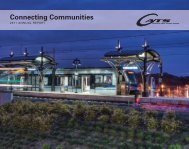
• Gateway Plaza – a public plaza to serve as a focal point for a mix of travelers, residents,<br />
workers and students. The plaza would include a variety of retail, public art and access<br />
to the various transportation facilities.<br />
• Private mixed-use development including air rights is envisioned on the CGS site. In<br />
addition, substantial complementary privately-funded mixed-used development will be<br />
constructed on adjacent NCDOT-owned property consistent with a Master Plan to be<br />
developed by NCDOT and Charlotte.<br />
S.2 Purpose of the EA<br />
In accordance with the National Environmental Policy Act (NEPA) and regulations and<br />
guidance from the Federal Transit Administration (FTA), this EA evaluates the social,<br />
economic, environmental, and transportation impacts that would result from implementation<br />
of CGS. The EA includes:<br />
• Analysis necessary to identify the social, economic, environmental, and transportation<br />
impacts of implementing CGS, as compared to the no-action alternative and a minimalaction<br />
base case;<br />
• Opportunities to avoid, minimize, and mitigate adverse impacts;<br />
• Projected project costs;<br />
The No-Action Alternative consists of the existing transportation facilities, plus committed<br />
transportation improvements, including projects under construction, projects in the State<br />
Transportation Improvement Program (STIP), the Mecklenburg Union Metropolitan Planning<br />
Organization’s (MUMPOs) Long-Range Transportation Plan (LRTP), and bus service<br />
improvements to which area transit providers have made financial commitments. The<br />
minimal-action base case includes facilities to accommodate NCCR service and on-street<br />
transit service.<br />
S.3 Planning Background and Decision Making History<br />
Planning for a multimodal station in Center City Charlotte has advanced on two separate<br />
fronts – as an integral component of the Charlotte regional transit program and separately<br />
as a key intercity rail passenger facility for current Amtrak service and future Southeast High<br />
Speed Rail service. The NCDOT began acquiring property for station development in 1998.<br />
Property acquisition totaling 27 acres was completed in February 2004. A 2002 feasibility<br />
study examined seven different station design options and eight different track layouts.<br />
Eighty-four meetings were held with various stakeholders, both public and private, to assist<br />
Charlotte Gateway Station S-4 EA