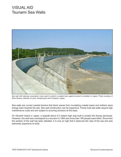
VISUAL AID Tsunami Sea Walls
VISUAL AID Tsunami Sea Walls
VISUAL AID Tsunami Sea Walls

Create successful ePaper yourself
Turn your PDF publications into a flip-book with our unique Google optimized e-Paper software.
<strong>VISUAL</strong> <strong>AID</strong><br />
<strong>Tsunami</strong> <strong>Sea</strong> <strong>Walls</strong><br />
<strong>Sea</strong> wall with stairway evacuation route used to protect a coastal town against tsunami inundation in Japan. Photo courtesy of<br />
River Bureau, Ministry of Land, Infrastructure and Transport, Japan.<br />
<strong>Sea</strong> walls are curved coastal barriers that block waves from inundating coastal areas and redirect wave<br />
energy back towards the sea. <strong>Sea</strong> wall construction can be expensive. Poorly built sea walls require high<br />
maintenance costs and are subject to scouring (erosion) at the base.<br />
On Okushiri Island in Japan, a seawall about 4.5 meters high was built to protect the Aonae peninsula.<br />
However, this wall was overtopped by a tsunami in 1993 and more than 185 people were killed. Since then<br />
the wisdom of the wall has been debated. It is now so high that it obstructs the view of the sea and was<br />
extremely expensive to build.<br />
ATEP ©2006-2010 UAF Geophysical Institute Structural Countermeasures<br />
ITC
<strong>VISUAL</strong> <strong>AID</strong><br />
<strong>Tsunami</strong> Breakwaters<br />
<strong>Tsunami</strong> breakwaters are offshore structures that restrict the inflow of tsunami and storm waves into a harbor<br />
by narrowing the entrance. Such a breakwater can be found in Ofunato Bay on Japan’s Sanriku Coast<br />
and can be viewed on Google Earth.<br />
Breakwaters are built as underwater berms and topped with an armor unit that dissipates incoming wave<br />
energy. Breakwaters are subject to scouring (erosion) at the base of the structure. They also have the<br />
potential to change a bay’s environment by decreasing water circulation.<br />
steel cell<br />
Breakwater<br />
45 ft.<br />
26 ft.<br />
292 ft.<br />
20 ft.<br />
rubble<br />
mound<br />
ATEP ©2006-2010 UAF Geophysical Institute Structural Countermeasures
<strong>VISUAL</strong> <strong>AID</strong><br />
Tetrapod<br />
Tetrapods are one type of concrete armor unit with four legs. Tetrapods are also used along the breakwater<br />
of Crescent City, California, a city with a strong history of tsunamis. It is important to note that some<br />
tsunami waves are powerful enough to transport tetrapods.<br />
ATEP ©2006-2010 UAF Geophysical Institute Structural Countermeasures
<strong>VISUAL</strong> <strong>AID</strong><br />
Shirahama Elevated Shelter<br />
Photo curtesy of N. Shuto<br />
This elevated shelter was built at a beach resort in Shirahama, Tokushima Prefecture, Japan. It can hold<br />
up to 700 people in an area of 7,535 square feet. Earthquake considerations include pipe piles driven<br />
about 66 feet deep into bedrock because of the potential for soil liquefaction. The elevation of this building<br />
is 11.5 meters tall. This is four meters higher than the design elevation of 7.5 meters based on the historic<br />
earthquake and tsunami that struck the area in 1854.<br />
ATEP ©2006-2010 UAF Geophysical Institute Structural Countermeasures
<strong>VISUAL</strong> <strong>AID</strong><br />
Nishiki Tower<br />
The Nishiki Tower is in the town of Nishiki, Mie Prefecture, Japan. This tsunami refuge is five stories tall<br />
and was constructed using reinforced concrete. In tsunami-free times the first floor is used for public toilet<br />
and storage space for fire equipment; the second floor for a meeting room; and the third floor for an archival<br />
library for natural disasters. The fourth and fifth floors have 786 square feet for evacuees. Nishiki Tower<br />
is designed to withstand a high intensity earthquake. The foundation consists of a 13 -foot deep sand and<br />
gravel layer with concrete piles extending 20 feet deep. <strong>Tsunami</strong> design includes a 6 meter evacuation<br />
elevation based on historic data and the building is designed to withstand the impact of a 10-ton ship at a<br />
velocity of 10 meters per second.<br />
ATEP ©2006-2010 UAF Geophysical Institute Structural Countermeasures<br />
FEMA
<strong>VISUAL</strong> <strong>AID</strong><br />
Water Gate on Okushiri Island<br />
This water gate is used to protect against tsunami waves on Okushiri Island,<br />
Japan. The gate begins to automatically close within seconds after earthquake<br />
shaking triggers its seismic sensors.<br />
ATEP ©2006-2010 UAF Geophysical Institute Structural Countermeasures<br />
ITIC
<strong>VISUAL</strong> <strong>AID</strong><br />
Elevated Platform on Okushiri Island<br />
This elevated platform serves as a tsunami evacuation site on Okushiri Island in<br />
Japan. In tsunami-free times it also serves as a scenic view point.<br />
ATEP ©2006-2010 UAF Geophysical Institute Structural Countermeasures<br />
ITIC
<strong>VISUAL</strong> <strong>AID</strong><br />
Existing High Ground<br />
100 feet<br />
Naturally occurring high ground may be used or modified for vertical tsunami evacuation.<br />
Large open areas on high ground offer easy access for large numbers of people with the<br />
added advantage of avoiding the possible anxiety of entering a building after an earthquake.<br />
Existing high ground should be evaluated for the potential of wave runup or erosion.<br />
ATEP ©2006-2010 UAF Geophysical Institute Structural Countermeasures
<strong>VISUAL</strong> <strong>AID</strong><br />
Tasukaru Tower<br />
ATEP ©2006-2010 UAF Geophysical Institute Structural Countermeasures<br />
FEMA<br />
Fujiwara Industries Company, Limited, of Japan developed<br />
the Tasukaru Tower. This economical structure<br />
can hold 50 people at an elevation of 5.8 meters. The<br />
span between the supporting posts is about 18 feet.
<strong>VISUAL</strong> <strong>AID</strong><br />
Berm<br />
FEMA<br />
A berm is artificial high ground. This berm was built in Aonae on Okushiri<br />
Island in Japan.<br />
ATEP ©2006-2010 UAF Geophysical Institute Structural Countermeasures<br />
FEMA
<strong>VISUAL</strong> <strong>AID</strong><br />
<strong>Tsunami</strong> Control Forest<br />
Cities and towns can plan for tsunami control forests between the shore and the developed part of town.<br />
The trees of the forest act as a buffer, helping to dissipate the wave energy as it washes ashore and filters<br />
out large ocean debris. Along the Sanriku Coast of Japan, the spruce tree is favored for their countertsunami<br />
groves. Coastal reefs are also protected for their potential to decrease the devastating effects of<br />
tsunamis.<br />
ATEP ©2006-2010 UAF Geophysical Institute Structural Countermeasures
<strong>VISUAL</strong> <strong>AID</strong><br />
Zoning<br />
Cities can zone low-lying high-risk tsunami areas for open space use or if necessary, for large lots. This<br />
may decrease the amount of people in a high-risk area and/or decrease the amount of potential damage<br />
or floating debris from a tsunami.<br />
Larger<br />
Lots<br />
=<br />
Lower<br />
Density<br />
Large lot zoning creates a lower density of land use in high risk areas.<br />
Smaller<br />
Lots<br />
=<br />
Higher<br />
Density<br />
In low risk areas, sites can be closer together.<br />
ATEP ©2006-2010 UAF Geophysical Institute Structural Countermeasures