Latitude and Longitude with Google Earth - ATEP
Latitude and Longitude with Google Earth - ATEP
Latitude and Longitude with Google Earth - ATEP

You also want an ePaper? Increase the reach of your titles
YUMPU automatically turns print PDFs into web optimized ePapers that Google loves.
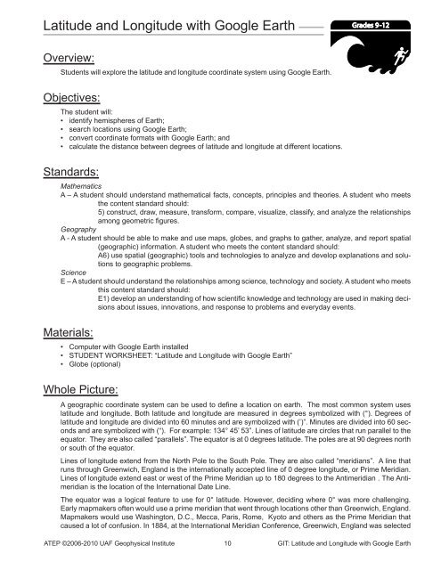
<strong>Latitude</strong> <strong>and</strong> <strong>Longitude</strong> <strong>with</strong> <strong>Google</strong> <strong>Earth</strong><br />
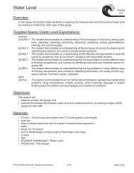
Overview:<br />
Students will explore the latitude <strong>and</strong> longitude coordinate system using <strong>Google</strong> <strong>Earth</strong>.<br />
Objectives:<br />
The student will:<br />
• identify hemispheres of <strong>Earth</strong>;<br />
• search locations using <strong>Google</strong> <strong>Earth</strong>;<br />
• convert coordinate formats <strong>with</strong> <strong>Google</strong> <strong>Earth</strong>; <strong>and</strong><br />
• calculate the distance between degrees of latitude <strong>and</strong> longitude at different locations.<br />
St<strong>and</strong>ards:<br />
Grades 9-12<br />
Mathematics<br />
A – A student should underst<strong>and</strong> mathematical facts, concepts, principles <strong>and</strong> theories. A student who meets<br />
the content st<strong>and</strong>ard should:<br />
5) construct, draw, measure, transform, compare, visualize, classify, <strong>and</strong> analyze the relationships<br />
among geometric figures.<br />
Geography<br />
A - A student should be able to make <strong>and</strong> use maps, globes, <strong>and</strong> graphs to gather, analyze, <strong>and</strong> report spatial<br />
(geographic) information. A student who meets the content st<strong>and</strong>ard should:<br />
A6) use spatial (geographic) tools <strong>and</strong> technologies to analyze <strong>and</strong> develop explanations <strong>and</strong> solutions<br />
to geographic problems.<br />
Science<br />
E – A student should underst<strong>and</strong> the relationships among science, technology <strong>and</strong> society. A student who meets<br />
this content st<strong>and</strong>ard should:<br />
E1) develop an underst<strong>and</strong>ing of how scientific knowledge <strong>and</strong> technology are used in making decisions<br />
about issues, innovations, <strong>and</strong> response to problems <strong>and</strong> everyday events.<br />
Materials:<br />
• Computer <strong>with</strong> <strong>Google</strong> <strong>Earth</strong> installed<br />
• STUDENT WORKSHEET: “<strong>Latitude</strong> <strong>and</strong> <strong>Longitude</strong> <strong>with</strong> <strong>Google</strong> <strong>Earth</strong>”<br />
• Globe (optional)<br />
Whole Picture:<br />
A geographic coordinate system can be used to define a location on earth. The most common system uses<br />
latitude <strong>and</strong> longitude. Both latitude <strong>and</strong> longitude are measured in degrees symbolized <strong>with</strong> (°). Degrees of<br />
latitude <strong>and</strong> longitude are divided into 60 minutes <strong>and</strong> are symbolized <strong>with</strong> (’)”. Minutes are divided into 60 seconds<br />
<strong>and</strong> are symbolized <strong>with</strong> (“). For example: 134° 45’ 53”. Lines of latitude are circles that run parallel to the<br />
equator. They are also called “parallels”. The equator is at 0 degrees latitude. The poles are at 90 degrees north<br />
or south of the equator.<br />
Lines of longitude extend from the North Pole to the South Pole. They are also called “meridians”. A line that<br />
runs through Greenwich, Engl<strong>and</strong> is the internationally accepted line of 0 degree longitude, or Prime Meridian.<br />
Lines of longitude extend east or west of the Prime Meridian up to 180 degrees to the Antimeridian . The Antimeridian<br />
is the location of the International Date Line.<br />
The equator was a logical feature to use for 0° latitude. However, deciding where 0° was more challenging.<br />
Early mapmakers often would use a prime meridian that went through locations other than Greenwich, Engl<strong>and</strong>.<br />
Mapmakers would use Washington, D.C., Mecca, Paris, Rome, Kyoto <strong>and</strong> others as the Prime Meridian that<br />
caused a lot of confusion. In 1884, at the International Meridian Conference, Greenwich, Engl<strong>and</strong> was selected<br />
<strong>ATEP</strong> ©2006-2010 UAF Geophysical Institute 10 GIT: <strong>Latitude</strong> <strong>and</strong> <strong>Longitude</strong> <strong>with</strong> <strong>Google</strong> <strong>Earth</strong>
as the official Prime Meridian. Specifically, the Prime Meridian passed through the cross hairs of the Airy’s Transit<br />
Circle at the Royal Observatory in Greenwich, Engl<strong>and</strong>. It was referred to as the Airy Meridian. However, as<br />
this lesson will demonstrate, the Prime Meridian used in <strong>Google</strong> <strong>Earth</strong> does not pass through the Observatory.<br />
Instead it is about 100 meters to the east. The reason is because <strong>Google</strong> <strong>Earth</strong> <strong>and</strong> GPS’s use the more current<br />
WGS84 datum. WGS84 is an acronym for World Geodetic Survey of 1984 <strong>and</strong> the term “datum” is the reference<br />
from which measurements are made. The WGS84 datum uses <strong>Earth</strong>’s center of mass for the coordinate<br />
origin <strong>and</strong> does not rely on a physical location, which can move <strong>with</strong> plate tectonics. The WGS84 datum has<br />
become the st<strong>and</strong>ard for cartography <strong>and</strong> navigation.<br />
Activity Preparation:<br />
<strong>Google</strong> <strong>Earth</strong> should be installed on computers prior to doing the lesson.<br />
In <strong>Google</strong> <strong>Earth</strong> Layers, Terrain <strong>and</strong> Borders should be clicked on. All the rest should be turned off. The default<br />
coordinate for <strong>Google</strong> <strong>Earth</strong> is degrees, minutes, seconds. When starting, each computer should have that setting.<br />
The option can be changed in <strong>Google</strong> <strong>Earth</strong> → Preferences. (Tools → Options for a PC)<br />
Students should be familiar <strong>with</strong> navigating around in <strong>Google</strong> <strong>Earth</strong> before doing this lesson. If necessary, have<br />
them do the “<strong>Google</strong> <strong>Earth</strong>” lesson before this one. It can be downloaded at http://www.aktsunami.com/lessons/GIT_exercises/5-8GIT.html.<br />
Activity Procedure:<br />
Ask students how they would describe the location of their school to someone who is familiar <strong>with</strong> the area. Next,<br />
ask how they would describe the location to someone who is not familiar <strong>with</strong> the area. Record the different ways<br />
of describing the location on the board. Ask students which method is the most accurate way to describe the location<br />
of the school. Ask if any students have used a GPS. If so, how does a GPS describe a location?<br />
Review <strong>with</strong> students the difference between latitude <strong>and</strong> longitude <strong>and</strong> how they are measured in degrees. If<br />
a globe is available use it to show the lines of latitude, longitude <strong>and</strong> degree measurements.<br />
Have students launch <strong>Google</strong> <strong>Earth</strong>. Demonstrate the navigation tools, how to measure <strong>with</strong> the ruler <strong>and</strong> share<br />
some keyboard shortcuts that are useful when moving around in <strong>Google</strong> <strong>Earth</strong>.<br />
Useful <strong>Google</strong> <strong>Earth</strong> keyboard shortcuts:<br />
n - moves the view so north is up.<br />
u - tilts the image so it is “top down” or up.<br />
r - rights the image so north is up <strong>and</strong> looking top down.<br />
H<strong>and</strong> out the STUDENT WORKSHEET: “<strong>Latitude</strong> <strong>and</strong> <strong>Longitude</strong> <strong>with</strong> <strong>Google</strong> <strong>Earth</strong>” <strong>and</strong> have students navigate<br />
around <strong>Google</strong> <strong>Earth</strong> to answer the questions. A separate answer sheet has also been provided for students.<br />
Answers:<br />
1. Arctic Circle<br />
Tropic of Cancer<br />
Equator<br />
Tropic of Capricorn<br />
Antarctic Circle<br />
2. 0°<br />
3. Approximately 71° 24’<br />
4. 141°<br />
5. “Prime Meridian of the World”<br />
6. No<br />
7. Approximately 102 meters to the east<br />
<strong>ATEP</strong> ©2006-2010 UAF Geophysical Institute 11 GIT: <strong>Latitude</strong> <strong>and</strong> <strong>Longitude</strong> <strong>with</strong> <strong>Google</strong> <strong>Earth</strong>
8. Place Eastern or Western Hemisphere Northern or Southern Hemisphere<br />
Adak, Alaska Western Northern<br />
Capetown, South Africa Eastern Southern<br />
Rio De Janeiro, Brazil Western Southern<br />
Tokyo, Japan Eastern Northern<br />
Quito, Ecuador Western Southern<br />
Madrid, Spain Western Northern<br />
9. a. Kodiak, AK<br />
b. Reno, NV<br />
c. Santiago, Chile.<br />
d. Portl<strong>and</strong>, OR<br />
10. Approximately 29 miles<br />
11. Answers will vary.<br />
12. Answers will vary.<br />
13. a. Statue of Liberty<br />
b. State of Alaska Capitol Building<br />
c. Gr<strong>and</strong> Canyon<br />
d. 38.9900, -77.0090<br />
e. 38°53’22”, -77°02’07”<br />
14. Near Adak, Alaska Near Barrow, Alaska<br />
Distance between one degree of latitude 70 miles 70 miles<br />
Distance between one degree of longitude 43 miles 22.5 miles<br />
15. None, they are the same.<br />
16. Near Barrow, one degree of longitude is approximately 20 miles less than it is near Adak.<br />
17. Lines of longitude converge, so the distance decreases towards the poles. Lines of latitude are equal distance<br />
from one another from the equator to the poles.<br />
18. It would be about 70 miles.<br />
19. It would be greater than the distance in Alaska. If measured, it is approximately 70 miles.<br />
<strong>ATEP</strong> ©2006-2010 UAF Geophysical Institute 12 GIT: <strong>Latitude</strong> <strong>and</strong> <strong>Longitude</strong> <strong>with</strong> <strong>Google</strong> <strong>Earth</strong>
Student Worksheet (page 1 of 7)<br />
<strong>Latitude</strong> <strong>and</strong> <strong>Longitude</strong> <strong>with</strong> <strong>Google</strong> <strong>Earth</strong><br />
Grades 9-12<br />
A geographic coordinate system can be used to define a location on earth. The most common system uses latitude<br />
<strong>and</strong> longitude. Any position on earth can be described by its latitude <strong>and</strong> longitude. These two numbers are the<br />
coordinates of the location. In this lesson <strong>Google</strong> <strong>Earth</strong> will be used to explore the latitude <strong>and</strong> longitude coordinate<br />
system.<br />
Directions: Follow the steps on the following pages. Fill in answers on pages 6 <strong>and</strong> 7 of this worksheet where indicated.<br />
STEP 1. Launch <strong>Google</strong> <strong>Earth</strong> <strong>and</strong> select View g Grid to turn on the grid lines showing latitude<br />
<strong>and</strong> longitude.<br />
STEP 2. Use the navigation tools to move the <strong>Earth</strong> from the North Pole to the South Pole.<br />
Answer questions 1-4 on page 6 of this worksheet.<br />
Prime Meridian<br />
In 1884 it was decided that the Prime Meridian, or the 0 degree line for longitude, would pass through the Royal<br />
Observatory in Greenwich, Engl<strong>and</strong>.<br />
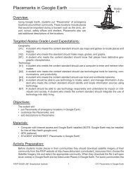
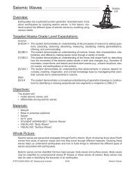
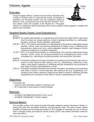
STEP 3. Type: Royal Observatory in the <strong>Google</strong> <strong>Earth</strong> search box. Press Return to “fly” to Greenwich, Engl<strong>and</strong>.<br />
Step 3 Step 4<br />
STEP 4. In Search turn off the balloons by clicking the<br />
check box. In Layers click Geographic Web then<br />
click Panaramio.<br />
<strong>ATEP</strong> ©2006-2010 UAF Geophysical Institute 13 GIT: <strong>Latitude</strong> <strong>and</strong> <strong>Longitude</strong> <strong>with</strong> <strong>Google</strong> <strong>Earth</strong>
Student Worksheet (page 2 of 7)<br />
<strong>Latitude</strong> <strong>and</strong> <strong>Longitude</strong> <strong>with</strong> <strong>Google</strong> <strong>Earth</strong><br />
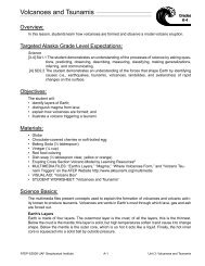
STEP 5. Look at the photo to locate the Royal Observatory. Click on some of the Panoramio blue squares to view<br />
photos of the Observatory (you may need to zoom in to see the individual squares).<br />
Answer question 5 on page 6 of this worksheet.<br />
STEP 6. Zoom out to see the yellow line that marks the “Prime Meridian” in <strong>Google</strong> <strong>Earth</strong>.<br />
NASA<br />
Answer questions 6 <strong>and</strong> 7 on page 6 of this worksheet.<br />
<strong>Google</strong> <strong>Earth</strong> <strong>and</strong> the Global Position System (GPS) use the center of mass of <strong>Earth</strong>, instead of a<br />
geographic location such as the Royal Observatory, as a reference point for the coordinate system.<br />
This eliminates the problem of tectonic plate movement.<br />
Hemispheres<br />
Locations between 0º <strong>and</strong> +180º are in the eastern hemisphere. Places between 0º <strong>and</strong><br />
-180º are in the western hemisphere. Locations between the equator <strong>and</strong> the North<br />
Pole (+90º) are in the northern hemisphere. Places between the equator <strong>and</strong> the South<br />
Pole (-90º) are in the southern hemisphere.<br />
Answer questions 8 <strong>and</strong> 9 on page XX of this worksheet.<br />
Coordinate Formats<br />
<strong>Latitude</strong> <strong>and</strong> longitude can be written in several different formats. They can be in degrees,<br />
minutes <strong>and</strong> seconds; degrees, decimal minutes; or in decimal degrees. There are<br />
60 minutes in a degree <strong>and</strong> 60 seconds in a minute. Additionally, coordinates using<br />
latitude <strong>and</strong> longitude must state whether they are east or west of the Prime Meridian <strong>and</strong><br />
north or south of the equator. This is done by using an “N” for points north of the equator<br />
<strong>and</strong> “S” or “-“ for south of the equator. <strong>Longitude</strong> east of the Prime Meridian is designated<br />
<strong>with</strong> an “E,” <strong>and</strong> a “W” or “-“ for west of the Prime Meridian. North latitudes <strong>and</strong> East<br />
longitudes would be positive “+” values <strong>and</strong> the + is not usually included.<br />
<strong>ATEP</strong> ©2006-2010 UAF Geophysical Institute 14 GIT: <strong>Latitude</strong> <strong>and</strong> <strong>Longitude</strong> <strong>with</strong> <strong>Google</strong> <strong>Earth</strong>
Student Worksheet (page 3 of 7)<br />
<strong>Latitude</strong> <strong>and</strong> <strong>Longitude</strong> <strong>with</strong> <strong>Google</strong> <strong>Earth</strong><br />
For example, each of these coordinates describes the exact same location.<br />
Degree minutes seconds Degree decimal minutes Decimal degrees<br />
61˚ 51’ 33.84”, -147˚ 50’ 58.2” 64˚ 51.564’, 147 50.97’ 64.8594˚, -147.8495˚<br />
61˚ 51’ 33.84” N, -147˚ 50’ 58.2” W 64˚ 51.564’ N, 147 50.97’ W 64.8594˚ N, -147.8495˚ W<br />
Although each of these is correct, decimal degrees is becoming more commonly used. This is because the coordinates<br />
can be used in spreadsheets.<br />
<strong>Google</strong> <strong>Earth</strong> can display each of these different formats at the bottom of the window.<br />
STEP 7. Open the preference file by selecting <strong>Google</strong> <strong>Earth</strong> g Preferences g 3D View (Tool g Options g 3D View on<br />
a PC) <strong>and</strong> click on Decimal Degrees if it is not already selected.<br />
The different formats can cause problems. For<br />
example, imagine you were working for your<br />
community Search <strong>and</strong> Rescue. A call comes in<br />
that a person was in trouble <strong>and</strong> needed help.<br />
The person had a GPS <strong>and</strong> by using a satellite<br />
phone they give the coordinates 58 52 52, -156<br />
55 42 but they did not say what format was being<br />
used. The dispatch officer assumed it was in<br />
degrees, minutes <strong>and</strong> seconds, but what if it was<br />
in decimal degrees? Find the distance between<br />
58° 52’ 52”, -156° 55’ 42” <strong>and</strong> 58.5252, -156.5542.<br />
Note that these coordinates use the same number<br />
sequence, but are in different formats.<br />
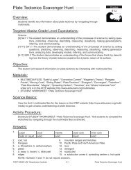
STEP 8. Enter 58 52 52, -156 55 42 in the search box of <strong>Google</strong><br />
<strong>Earth</strong>. NOTE: <strong>Google</strong> <strong>Earth</strong> interprets the spaces as coordinates<br />
in degrees, minutes <strong>and</strong> seconds. The symbols do not need to<br />
be included.<br />
STEP 9. Enter 58.5252, -156.5542 in the search box of <strong>Google</strong> <strong>Earth</strong>.<br />
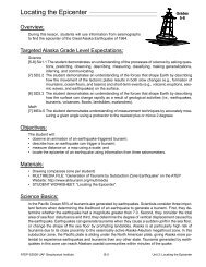
STEP 10. Click on both of the coordinates in the<br />
search box then use the ruler to measure the<br />
distance, in miles, between the two locations.<br />
Clear the measurement when finished.<br />
Answer question 10 on page 6 of this worksheet.<br />
Step 7<br />
For a complete set of instruc tions<br />
on latitude <strong>and</strong> longitude syntax in<br />
<strong>Google</strong> <strong>Earth</strong> see the <strong>Google</strong> <strong>Earth</strong><br />
Users Guide at: http://earth.google.<br />
com/userguide/v4/ug_editing.html<br />
Steps 8-10<br />
<strong>ATEP</strong> ©2006-2010 UAF Geophysical Institute 15 GIT: <strong>Latitude</strong> <strong>and</strong> <strong>Longitude</strong> <strong>with</strong> <strong>Google</strong> <strong>Earth</strong>
Student Worksheet (page 4 of 7)<br />
<strong>Latitude</strong> <strong>and</strong> <strong>Longitude</strong> <strong>with</strong> <strong>Google</strong> <strong>Earth</strong><br />
STEP 11. Type the name of your community in the <strong>Google</strong> <strong>Earth</strong> search box. Press Return to fly to it.<br />
STEP 12. Navigate in <strong>Google</strong> <strong>Earth</strong> to your school.<br />
STEP 13. Move the mouse pointer around <strong>and</strong> look at the bottom of the <strong>Google</strong> <strong>Earth</strong> window. Notice how the<br />
latitude <strong>and</strong> longitude change to show the current position of the mouse. Place the mouse pointer over your<br />
school.<br />
Answer question 11 on page 7 of this worksheet.<br />
STEP 14. In <strong>Google</strong> <strong>Earth</strong> navigate to the airstrip nearest your school.<br />
Answer questions 12 <strong>and</strong> 13 on page 7 of this worksheet.<br />
Distances between longitude <strong>and</strong> latitude<br />
Is the distance between one degree of longitude the same in Barrow, AK as it is in Adak, Alaska? What about the<br />
distance between one degree of longitude at the two locations? Are they the same? Use <strong>Google</strong> <strong>Earth</strong> to find the<br />
answer.<br />
STEP 15. Type: Adak, AK in the <strong>Google</strong> <strong>Earth</strong> search box, then press Return to fly to that location.<br />
STEP 16. Type the coordinates: 51.00, -176.5 in the <strong>Google</strong> <strong>Earth</strong> search box <strong>and</strong> press Return.<br />
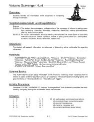
STEP 17. Type the coordinates: 52.00, -176.5 in the <strong>Google</strong> <strong>Earth</strong><br />
search box <strong>and</strong> press Return.<br />
STEP 18. Click both of the coordinates on so they are visible in the<br />
<strong>Google</strong> <strong>Earth</strong> window.<br />
STEP 19. Use the ruler to measure the distance, in miles,<br />
between 51.00, -176.5 <strong>and</strong> 52.00, -176.5 <strong>and</strong> write<br />
the distance of one degree of latitude in the table<br />
on page XX of this worksheet.<br />
STEP 20. Type the coordinates: 52.00, -176.00 in the<br />
<strong>Google</strong> <strong>Earth</strong> search box <strong>and</strong> press Return.<br />
STEP 21. Type the coordinates: 52.00, -177.00 in the<br />
<strong>Google</strong> <strong>Earth</strong> search box <strong>and</strong> press Return.<br />
Step 19<br />
Step 13<br />
Step 17-18<br />
<strong>ATEP</strong> ©2006-2010 UAF Geophysical Institute 16 GIT: <strong>Latitude</strong> <strong>and</strong> <strong>Longitude</strong> <strong>with</strong> <strong>Google</strong> <strong>Earth</strong>
Student Worksheet (page 5 of 7)<br />
<strong>Latitude</strong> <strong>and</strong> <strong>Longitude</strong> <strong>with</strong> <strong>Google</strong> <strong>Earth</strong><br />
STEP 22. As in STEP 17–STEP 18 click on both the coordinates so they are visible in <strong>Google</strong> <strong>Earth</strong> <strong>and</strong> use the<br />
ruler to measure the distance of one degree of longitude. Write the distance of one degree of latitude in the<br />
table on page 7 of this worksheet.<br />
STEP 23. Type: Barrow, AK in the <strong>Google</strong> <strong>Earth</strong> search box <strong>and</strong> press Return to fly there.<br />
STEP 24. Type the coordinates: 71.00, -156.8 in the <strong>Google</strong> <strong>Earth</strong> search box <strong>and</strong> press Return.<br />
STEP 25. Type the coordinates: 72.00, -156.8 in the <strong>Google</strong> <strong>Earth</strong> search box <strong>and</strong> press Return.<br />
STEP 26. Click on both coordinates, <strong>and</strong> then use the ruler to measure the distance between one degree of latitude<br />
near Barrow. Write this information in the table (question 14) on page 7 of this worksheet.<br />
STEP 27. Enter the coordinates: 71.5, -156.0 in the <strong>Google</strong> <strong>Earth</strong> search box <strong>and</strong> press Return.<br />
STEP 28. Enter the coordinates: 71.5, -157.0 in the <strong>Google</strong> <strong>Earth</strong> search box <strong>and</strong> press Return.<br />
STEP 29. Click on both coordinates, <strong>and</strong> then use the ruler to measure the distance between one degree of longitude<br />
near Barrow. Write this information in the table (question 14) on page 7 of this worksheet.<br />
Answer questions 15-19 on page 7 of this worksheet.<br />
<strong>ATEP</strong> ©2006-2010 UAF Geophysical Institute 17 GIT: <strong>Latitude</strong> <strong>and</strong> <strong>Longitude</strong> <strong>with</strong> <strong>Google</strong> <strong>Earth</strong>
Name:____________________________________<br />
Student Worksheet (page 6 of 7)<br />
<strong>Latitude</strong> <strong>and</strong> <strong>Longitude</strong> <strong>with</strong> <strong>Google</strong> <strong>Earth</strong><br />
Directions: Use the step-by-step instructions on the preceeding pages of this worksheet to answer the following<br />
questions.<br />
1. List the five major lines of latitude going from north to south.<br />
____________________________________ ______________________________________<br />
____________________________________ ______________________________________<br />
____________________________________<br />
2. What is the equator’s degree latitude? ______________________________________________________<br />
3. What degree latitude is the northern most point in Alaska? ______________________________________<br />
4. What degree longitude is the eastern border between Alaska <strong>and</strong> Canada? _________________________<br />
5. What does the poster on the Royal Observatory say? __________________________________________<br />
6. Does the Prime Meridian pass through the Royal Observatory? __________________________________<br />
7. Use the ruler to measure the distance, in meters, from the Prime Meridian used in <strong>Google</strong> <strong>Earth</strong> to the one used<br />
in 1884. Record the distance measured. ____________________________________________________<br />
8. Use the grid in <strong>Google</strong> <strong>Earth</strong> to complete the chart. Fill in the correct hemispheres for each location.<br />
Location<br />
Adak, Alaska<br />
Capetown, South Africa<br />
Rio de Janeiro, Brazil<br />
Tokyo, Japan<br />
Quito, Ecuador<br />
Madrid, Spain<br />
Eastern or Western Hemisphere Northern or Southern Hemisphere<br />
9. Refer to the grid lines in <strong>Google</strong> <strong>Earth</strong>. Circle the correct answer to the following questions.<br />
a. Which is farther south? Juneau, Alaska or Kodiak, Alaska?<br />
b. Which is farther west? Reno, Nevada or Los Angeles California?<br />
c. Which is farther east? Santiago, Chile or New York, New York?<br />
d. Which is farther north? Portl<strong>and</strong>, Oregon or Boston, Massachusetts?<br />
10. What is the distance, in miles, between 58° 52’ 52”, -156° 55’ 42” <strong>and</strong> 58.5252, -156.5542?<br />
____________________________________________________________________________________<br />
<strong>ATEP</strong> ©2006-2010 UAF Geophysical Institute 18 GIT: <strong>Latitude</strong> <strong>and</strong> <strong>Longitude</strong> <strong>with</strong> <strong>Google</strong> <strong>Earth</strong>
Name:____________________________________<br />
Student Worksheet (page 7 of 7)<br />
<strong>Latitude</strong> <strong>and</strong> <strong>Longitude</strong> <strong>with</strong> <strong>Google</strong> <strong>Earth</strong><br />
11. In the chart below, fill in the coordinates for your school in each format.<br />
Format School Coordinates<br />
Decimal degrees<br />
Degrees, decimal minutes<br />
Degrees, minutes, seconds<br />
12. What are the coordinates, in decimal degrees, for each end of the airstrip? __________________________<br />
13. Use <strong>Google</strong> <strong>Earth</strong> to answer the following questions.<br />
a. What famous statue is at 40.6891, -74.0446 (hint: look at the shadow)? _______________________<br />
b. What is the building at 58.3021, -134.4104 (hint: turn on places)? ____________________________<br />
c. What feature is at 36.0901, -113.2283 (hint: tilt the view)? __________________________________<br />
d. What are the coordinates, in decimal degrees, of the U.S. Capitol? ___________________________<br />
e. What are the coordinates, in degrees, minutes, seconds, of the Washington Monument in Washington D.C.?<br />
__________________________________________________________________________________<br />
14. Distance between:<br />
one degree of latitude<br />
one degree of longitude<br />
Near Adak, AK Near Barrow, AK<br />
15. What is the difference between one degree of latitude between Adak, AK <strong>and</strong> Barrow, AK?<br />
____________________________________________________________________________________<br />
16 What is the difference between one degree of longitude between Adak, AK <strong>and</strong> Barrow, AK?<br />
____________________________________________________________________________________<br />
17. Why is there a difference between measurements of one degree of longitude <strong>and</strong> latitude at the two locations?<br />
____________________________________________________________________________________<br />
18. What would you estimate the distance between one degree of latitude near the equator to be?<br />
____________________________________________________________________________________<br />
19. What would you estimate the distance between one degree of longitude near the equator to be?<br />
____________________________________________________________________________________<br />
<strong>ATEP</strong> ©2006-2010 UAF Geophysical Institute 19 GIT: <strong>Latitude</strong> <strong>and</strong> <strong>Longitude</strong> <strong>with</strong> <strong>Google</strong> <strong>Earth</strong>