Latitude and Longitude with Google Earth - ATEP
Latitude and Longitude with Google Earth - ATEP
Latitude and Longitude with Google Earth - ATEP
You also want an ePaper? Increase the reach of your titles
YUMPU automatically turns print PDFs into web optimized ePapers that Google loves.
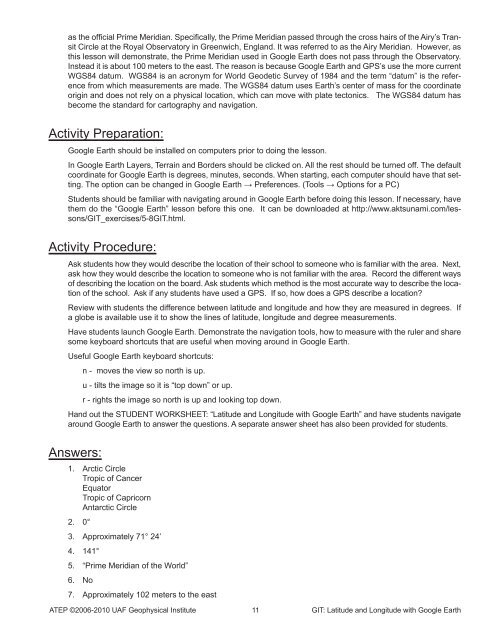
as the official Prime Meridian. Specifically, the Prime Meridian passed through the cross hairs of the Airy’s Transit<br />
Circle at the Royal Observatory in Greenwich, Engl<strong>and</strong>. It was referred to as the Airy Meridian. However, as<br />
this lesson will demonstrate, the Prime Meridian used in <strong>Google</strong> <strong>Earth</strong> does not pass through the Observatory.<br />
Instead it is about 100 meters to the east. The reason is because <strong>Google</strong> <strong>Earth</strong> <strong>and</strong> GPS’s use the more current<br />
WGS84 datum. WGS84 is an acronym for World Geodetic Survey of 1984 <strong>and</strong> the term “datum” is the reference<br />
from which measurements are made. The WGS84 datum uses <strong>Earth</strong>’s center of mass for the coordinate<br />
origin <strong>and</strong> does not rely on a physical location, which can move <strong>with</strong> plate tectonics. The WGS84 datum has<br />
become the st<strong>and</strong>ard for cartography <strong>and</strong> navigation.<br />
Activity Preparation:<br />
<strong>Google</strong> <strong>Earth</strong> should be installed on computers prior to doing the lesson.<br />
In <strong>Google</strong> <strong>Earth</strong> Layers, Terrain <strong>and</strong> Borders should be clicked on. All the rest should be turned off. The default<br />
coordinate for <strong>Google</strong> <strong>Earth</strong> is degrees, minutes, seconds. When starting, each computer should have that setting.<br />
The option can be changed in <strong>Google</strong> <strong>Earth</strong> → Preferences. (Tools → Options for a PC)<br />
Students should be familiar <strong>with</strong> navigating around in <strong>Google</strong> <strong>Earth</strong> before doing this lesson. If necessary, have<br />
them do the “<strong>Google</strong> <strong>Earth</strong>” lesson before this one. It can be downloaded at http://www.aktsunami.com/lessons/GIT_exercises/5-8GIT.html.<br />
Activity Procedure:<br />
Ask students how they would describe the location of their school to someone who is familiar <strong>with</strong> the area. Next,<br />
ask how they would describe the location to someone who is not familiar <strong>with</strong> the area. Record the different ways<br />
of describing the location on the board. Ask students which method is the most accurate way to describe the location<br />
of the school. Ask if any students have used a GPS. If so, how does a GPS describe a location?<br />
Review <strong>with</strong> students the difference between latitude <strong>and</strong> longitude <strong>and</strong> how they are measured in degrees. If<br />
a globe is available use it to show the lines of latitude, longitude <strong>and</strong> degree measurements.<br />
Have students launch <strong>Google</strong> <strong>Earth</strong>. Demonstrate the navigation tools, how to measure <strong>with</strong> the ruler <strong>and</strong> share<br />
some keyboard shortcuts that are useful when moving around in <strong>Google</strong> <strong>Earth</strong>.<br />
Useful <strong>Google</strong> <strong>Earth</strong> keyboard shortcuts:<br />
n - moves the view so north is up.<br />
u - tilts the image so it is “top down” or up.<br />
r - rights the image so north is up <strong>and</strong> looking top down.<br />
H<strong>and</strong> out the STUDENT WORKSHEET: “<strong>Latitude</strong> <strong>and</strong> <strong>Longitude</strong> <strong>with</strong> <strong>Google</strong> <strong>Earth</strong>” <strong>and</strong> have students navigate<br />
around <strong>Google</strong> <strong>Earth</strong> to answer the questions. A separate answer sheet has also been provided for students.<br />
Answers:<br />
1. Arctic Circle<br />
Tropic of Cancer<br />
Equator<br />
Tropic of Capricorn<br />
Antarctic Circle<br />
2. 0°<br />
3. Approximately 71° 24’<br />
4. 141°<br />
5. “Prime Meridian of the World”<br />
6. No<br />
7. Approximately 102 meters to the east<br />
<strong>ATEP</strong> ©2006-2010 UAF Geophysical Institute 11 GIT: <strong>Latitude</strong> <strong>and</strong> <strong>Longitude</strong> <strong>with</strong> <strong>Google</strong> <strong>Earth</strong>


