

Etude stratigraphique, pétrographique et diagénétique des grès d ...
Etude stratigraphique, pétrographique et diagénétique des grès d ...
Etude stratigraphique, pétrographique et diagénétique des grès d ...

You also want an ePaper? Increase the reach of your titles
YUMPU automatically turns print PDFs into web optimized ePapers that Google loves.
tel-00534181, version 1 - 9 Nov 2010<br />
�<br />
Chapter I<br />
Figure 6. (a) Schematic map of Africa showing the<br />
major structures of the Central African Rift System<br />
(CARS) and the East African Rift System (EARS). (b)<br />
Distribution of surface and subsurface Cr<strong>et</strong>aceous<br />
siliciclastic formations in central (Sudan) and eastern<br />
(Ethiopia, Kenya) Africa (from Vail, 1974;<br />
Beauchamp, 1988). Exploration wells drilled in the<br />
Anza Rift, showing occurrences of Cr<strong>et</strong>aceous<br />
marine and non-marine sediments, are indicated<br />
(from Morley <strong>et</strong> al., 1999b). (c) Schematic map showing<br />
the distribution of Cr<strong>et</strong>aceous(?) to<br />
Paleogene-Neogene rift basins in south Sudan and<br />
northern-central Kenya. The Loperot-1 well, drilled<br />
in the Lokichar Basin, and the Eliye Springs well,<br />
drilled in the Turkana/Lothidok Basin, respectively,<br />
are indicated (modified from Wescott <strong>et</strong> al., 1999;<br />
Ebinger and Ibrahim, 1994; Tiercelin <strong>et</strong> al., 2004).<br />
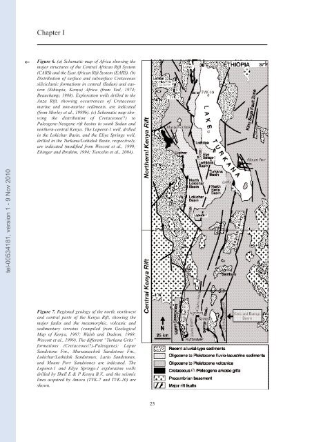
Figure 7. Regional geology of the north, northwest<br />
and central parts of the Kenya Rift, showing the<br />
major faults and the m<strong>et</strong>amorphic, volcanic and<br />
sedimentary terrains (compiled from Geological<br />
Map of Kenya, 1987; Walsh and Dodson, 1969;<br />
Wescott <strong>et</strong> al., 1999). The different “Turkana Grits”<br />
formations (Cr<strong>et</strong>aceous(?)-Paleogene): Lapur<br />
Sandstone Fm., Muruanachok Sandstone Fm.,<br />
Lokichar/Lothidok Sandstones, Lariu Sandstones,<br />
and Mount Porr Sandstones are indicated. The<br />
Loperot-1 and Eliye Springs-1 exploration wells<br />
drilled by Shell E & P Kenya B.V., and the seismic<br />
lines acquired by Amoco (TVK-7 and TVK-10) are<br />
shown.<br />
25


