

Etude stratigraphique, pétrographique et diagénétique des grès d ...
Etude stratigraphique, pétrographique et diagénétique des grès d ...
Etude stratigraphique, pétrographique et diagénétique des grès d ...

Create successful ePaper yourself
Turn your PDF publications into a flip-book with our unique Google optimized e-Paper software.
tel-00534181, version 1 - 9 Nov 2010<br />
Chapter I<br />
(b)<br />
31<br />
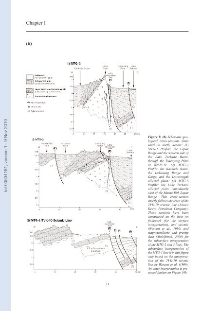
Figure 9. (b) Schematic geological<br />
cross-sections, from<br />
south to north, across: (1)<br />
MTG-1 Profile: the Lapur<br />
Range and the western side of<br />
the Lake Turkana Basin,<br />
through the Todenyang Plain<br />
at 04°25’N; (2) MTG-2<br />
Profile: the Kachoda Basin,<br />
the Lokitaung Range and<br />
Gorge, and the Lowarengak<br />
alluvial plain; (3) MTG-3<br />
Profile: the Lake Turkana<br />
alluvial plain immediately<br />
west of the Murua Rith-Lapur<br />
Range. This cross-section<br />
strictly follows the trace of the<br />
TVK-10 seismic line (Amoco<br />
Kenya P<strong>et</strong>roleum Company).<br />
These sections have been<br />
constructed on the base on<br />
fieldwork (for the surface<br />
interpr<strong>et</strong>ation), and seismic<br />
(Wescott <strong>et</strong> al., 1999) and<br />
magn<strong>et</strong>otelluric and gravity<br />
data (Abdelf<strong>et</strong>tah, 2009) for<br />
the subsurface interpr<strong>et</strong>ation<br />
of the MTG-2 and 3 lines. The<br />
subsurface interpr<strong>et</strong>ation of<br />
the MTG-1 line is in this figure<br />
only based on the interpr<strong>et</strong>ation<br />
of the TVK-10 seismic<br />
line by Wescott <strong>et</strong> al. (1999).<br />
An other interpr<strong>et</strong>ation is presented<br />
further on Figure 19b.


