

Etude stratigraphique, pétrographique et diagénétique des grès d ...
Etude stratigraphique, pétrographique et diagénétique des grès d ...
Etude stratigraphique, pétrographique et diagénétique des grès d ...

Create successful ePaper yourself
Turn your PDF publications into a flip-book with our unique Google optimized e-Paper software.
tel-00534181, version 1 - 9 Nov 2010<br />
�<br />
Chapter I<br />
sive system visible within the upper parts of the LSF. These two lavas are p<strong>et</strong>rographically and geochemically<br />
similar. They are intensively altered basaltic rocks showing mainly secondary calcite and brown<br />
clays. Plagioclase, clinopyroxene and olivine phenocrysts can still be recognized within KER 63/05 sample<br />
whereas KER 64/05 is totally altered (Tables 5 and 6).<br />
Many other dykes of various trends (N0°, N50-70°, N90°, N160°) and widths (from a few decim<strong>et</strong>ers<br />
up to 10 m) as well as sills have been observed to crosscut the LSF and to intersect each other at<br />
Keniroliom, Kerral, Lokitaung Gorge areas (Fig. 16c-f). In the Lapur Peak area, a few narrow basaltic dykes<br />
(max. 0.80 m wide) were seen intruding the amphibolitic basement (Fig. 16g, h). Dating such dykes has been<br />
difficult because of the deep alteration of the rocks. Nevertheless, in the Kerral area, one of the largest dykes<br />
- ~10 m wide, several hundreds of m long, trending N60° - and which is seen crosscutting the middle and upper<br />
terms of LSF (Fig. 16c, d), is a relatively fresh lava (sample KER 65/05 collected at lat. 04°15’01”N; long.<br />
35°48’23”E) which has been geochemically characterised as a tephrite. It has been dated 27.03 ± 0.57 Ma<br />
(Tables 5, 6 and 7b). This lava is of similar age to that of the 15-m thick tephrite flow sampled in the upstream<br />
part of the Lokitaung Gorge, near the town of Lokitaung at lat. 04°15’43”N; long. 35°45’23”E (sample LAP<br />
02/13D), which is dated 27.81 ± 0.65 Ma (Fig. 14; section LOK A) (Tables 5, 6 and 7a). Other volcanics of<br />
similar age have been characterised within the Turkana Volcanics south of the Lokitaung Gorge (Nathura Laga<br />
section; lat. 04°10’02’’N; long. 35°47’32’’E; Fig. 9a), where they are represented by rhyolitic sills and dykes<br />
(samples NATH 08/04 and 09/04) that have been dated 28.73 ± 0.64 Ma and 27.40 ± 0.66 Ma, respectively<br />
(Clément, Bellon <strong>et</strong> al., work in progress) (Table 7a). These data suggest volcanic phases of upper Oligocene<br />
age marked by the emplacement at the base of Lapur sandstones of intrusive bodies (dykes and sills) and overlying<br />
lava flows, both characterised by silica undersaturated (tephrites) or silica supersaturated lavas. New<br />
geochemical studies will confirm wh<strong>et</strong>her or not those lavas may belong to the same magmatic phase<br />
(Clément, Bellon <strong>et</strong> al., work in progress).<br />
4.2. Structural framework of LSF at the scale of the Turkana depression<br />
(Figs. 9b and 17)<br />
The Lapur Range (Fig. 8), an impressive 50 km-long range, is the only place where, at outcrop level,<br />
the Lapur Sandstone Formation can be seen and its proper stratigraphic position identified. Due to its general<br />
dip to the W-SW, exposures of the LSF disappears rapidly below the overlying Turkana Volcanics (Figs. 8 and<br />
9b). Farther to the west (Fig. 7), in the Gatome and Lotikipi Basins, poorly imaged sub-volcanic strata have<br />
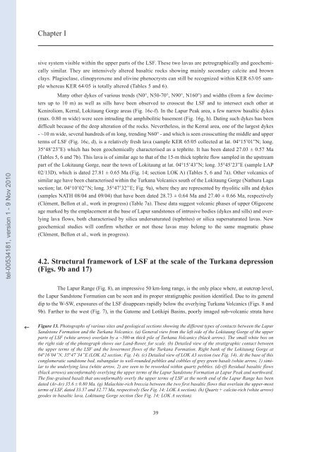
Figure 13. Photographs of various sites and geological sections showing the different types of contacts b<strong>et</strong>ween the Lapur<br />
Sandstone Formation and the Turkana Volcanics. (a) General view from the left side of the Lokitaung Gorge of the upper<br />
parts of LSF (white arrow) overlain by a ~500-m thick pile of Turkana Volcanics (black arrow). The small white box on<br />
the right side of the photograph shows our Land-Rover, for scale. (b) D<strong>et</strong>ailed view of the stratigraphic contact b<strong>et</strong>ween<br />
the upper terms of the LSF and the lowermost flows of the Turkana Formation. Right bank of the Lokitaung Gorge at<br />
04°16’04”N, 35°47’34”E (LOK A2 section; Fig. 14). (c) D<strong>et</strong>ailed view of LOK A3 section (see Fig. 14). At the base of this<br />
conglomeratic sandstone bed, subangular to well-rounded pebbles and cobbles of grey green basalt (white arrow, 1) similar<br />
to the underlying lava (white arrow, 2) are seen to be reworked within quartz pebbles. (d)-(f) Residual basaltic flows<br />
(black arrows) unconformably overlying the upper terms of the Lapur Sandstone Formation at Lapur Peak and northward.<br />
The fine-grained basalt that unconformably overly the upper terms of LSF at the north end of the Lapur Range has been<br />
dated (Ar-Ar) 35.6 ± 0.80 Ma. (g) Malachite-rich breccia b<strong>et</strong>ween the two first basaltic flows that overlain the upper-most<br />
terms of LSF, dated 33.57 and 32.77 Ma, respectively (See Fig. 14; LOK A section). (h) Quartz + calcite-rich (white arrow)<br />
geo<strong>des</strong> in basaltic lava, Lokituang Gorge section (See Fig. 14; LOK A section).<br />
39


