PACIFIC ISLANDS DIGITAL ELEVATION MODELS - NOAA National ...
PACIFIC ISLANDS DIGITAL ELEVATION MODELS - NOAA National ...
PACIFIC ISLANDS DIGITAL ELEVATION MODELS - NOAA National ...

You also want an ePaper? Increase the reach of your titles
YUMPU automatically turns print PDFs into web optimized ePapers that Google loves.
© 2011 Google<br />
<strong>NOAA</strong> Knows...<br />
Who Provided the Data?<br />
- <strong>NOAA</strong> <strong>National</strong> Geophysical Data Center (NGDC)<br />
- <strong>NOAA</strong> <strong>National</strong> Ocean Service (NOS)<br />
- U.S. Geological Survey (USGS)<br />
- U.S. Army Corps of Engineers (USACE)<br />
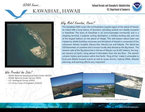
KAWAIHAE, HAWAII<br />
Why Model Kawaihae, Hawaii?<br />
<strong>National</strong> Oceanic and Atmospheric Administration<br />
U.S. Department of Commerce<br />
The Kawaihae DEM covers the northwestern coastal region of the island of Hawaii,<br />
an island with a long history of tsunamis, including several non-deadly tsunamis<br />
in Kawaihae. The town of Kawaihae is an unincorporated community and is a<br />
shipping terminal, a popular surfi ng destination, a military landing site, and one<br />
of the largest harbors on the island of Hawaii. This well known island chain was<br />
created by shield-building volcanoes and the Island of Hawaii is composed of fi ve<br />
volcanoes: Kohala, Hualalai, Mauna Kea, Mauna Loa, and Kilauea. The island has<br />
428 kilometers of coastline and is known locally and abroad as the Big Island. The<br />
western side of the Big Island lies in the lee of Mauna Loa (4,205 meters), the largest<br />
volcano on Earth, rising almost 9 kilometers from the sea fl oor. The island’s<br />
volcanic history and location within the Pacifi c “Ring of Fire” make it vulnerable to<br />
local and distant tsunami events as well as ocean storms, making DEMs, disaster<br />
planning, and warning efforts very important.<br />
Photo Credit: www.poh.usace.army.mil<br />
http://www.ngdc.noaa.gov/mgg/coastal/ dem.info@noaa.gov