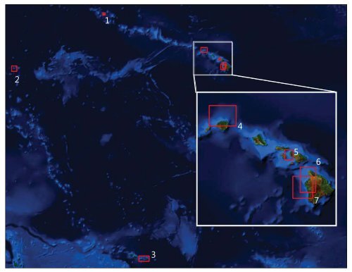
<strong>PACIFIC</strong> <strong>ISLANDS</strong> United States Pacifi c Islands and territories are dispersed mostly across the southern Pacifi c Ocean. This geographic area – also known as Oceania, includes over 30,000 islands that are broken up into the regional groups of Melanesia, Micronesia, and Polynesia. These island groups consist of small atolls and cays, coral islands, expansive barrier reefs, and high volcanic islands. The islands include well known landmarks such as the Hawaiian Islands, American Samoa, Fiji, and Guam. More than just tropical travel destinations, these islands are home to thousands of residents whose local indigenous populations are mixed with western culture. Communities and people who inhabit the tropical Pacifi c islands— especially in developments near the coast— are extremely vulnerable to severe storms, coastal inundation events, typhoons, earthquakes, and, as shown by the 2009 event that killed 149 people, 34 in American Samoa alone, tsunamis. Seismic activity at plate boundaries along the Pacifi c Ring of Fire, along with other tectonic stresses, deep-sea trenches, submerged volcanoes, and undersea features, increase the likelihood of risks associated with deadly large-wave events. Every year, coastal inundation events cause millions of dollars in damages and often loss of life. The <strong>National</strong> Geophysical Data Center’s digital elevation models (DEMs) provide detailed, accurate depictions of the coastal bathymetry and topography of the Pacifi c U.S. Islands and territories. The models are used by scientists, coastal managers, and policy makers to effectively maintain marine ecosystems and coastal resources, coordinate planning and mitigation efforts, and better understand the impacts of natural hazards on coastal communities. 1. Midway Atoll 2. Wake Island 3. Pago Pago 4. Hanalei 5. Lahaina 6. Kawaihae 7. Keauhou
2 1 3 4 5 6 7