PACIFIC ISLANDS DIGITAL ELEVATION MODELS - NOAA National ...
PACIFIC ISLANDS DIGITAL ELEVATION MODELS - NOAA National ...
PACIFIC ISLANDS DIGITAL ELEVATION MODELS - NOAA National ...

You also want an ePaper? Increase the reach of your titles
YUMPU automatically turns print PDFs into web optimized ePapers that Google loves.
© 2011 Google<br />
Who Provided the Data?<br />
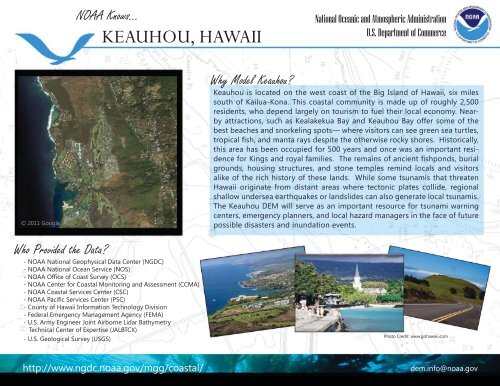
<strong>NOAA</strong> Knows...<br />
KEAUHOU, HAWAII<br />
- <strong>NOAA</strong> <strong>National</strong> Geophysical Data Center (NGDC)<br />
- <strong>NOAA</strong> <strong>National</strong> Ocean Service (NOS)<br />
- <strong>NOAA</strong> Offi ce of Coast Survey (OCS)<br />
- <strong>NOAA</strong> Center for Coastal Monitoring and Assessment (CCMA)<br />
- <strong>NOAA</strong> Coastal Services Center (CSC)<br />
- <strong>NOAA</strong> Pacifi c Services Center (PSC)<br />
- County of Hawaii Information Technology Division<br />
- Federal Emergency Management Agency (FEMA)<br />
- U.S. Army Engineer Joint Airborne Lidar Bathymetry<br />
Technical Center of Expertise (JALBTCX)<br />
- U.S. Geological Survey (USGS)<br />
http://www.ngdc.noaa.gov/mgg/coastal/<br />
Why Model Keauhou?<br />
<strong>National</strong> Oceanic and Atmospheric Administration<br />
U.S. Department of Commerce<br />
Keauhou is located on the west coast of the Big Island of Hawaii, six miles<br />
south of Kailua-Kona. This coastal community is made up of roughly 2,500<br />
residents, who depend largely on tourism to fuel their local economy. Nearby<br />
attractions, such as Kealakekua Bay and Keauhou Bay offer some of the<br />
best beaches and snorkeling spots— where visitors can see green sea turtles,<br />
tropical fi sh, and manta rays despite the otherwise rocky shores. Historically,<br />
this area has been occupied for 500 years and once was an important residence<br />
for Kings and royal families. The remains of ancient fi shponds, burial<br />
grounds, housing structures, and stone temples remind locals and visitors<br />
alike of the rich history of these lands. While some tsunamis that threaten<br />
Hawaii originate from distant areas where tectonic plates collide, regional<br />
shallow undersea earthquakes or landslides can also generate local tsunamis.<br />
The Keauhou DEM will serve as an important resource for tsunami warning<br />
centers, emergency planners, and local hazard managers in the face of future<br />
possible disasters and inundation events.<br />
Photo Credit: www.gohawaii.com<br />
dem.info@noaa.gov