PACIFIC ISLANDS DIGITAL ELEVATION MODELS - NOAA National ...
PACIFIC ISLANDS DIGITAL ELEVATION MODELS - NOAA National ...
PACIFIC ISLANDS DIGITAL ELEVATION MODELS - NOAA National ...

You also want an ePaper? Increase the reach of your titles
YUMPU automatically turns print PDFs into web optimized ePapers that Google loves.
© 2011 Google<br />
<strong>NOAA</strong> Knows...<br />
Who Provided the Data?<br />
WAKE ISLAND<br />
- <strong>NOAA</strong> <strong>National</strong> Ocean Service (NOS)<br />
- <strong>NOAA</strong> <strong>National</strong> Geophysical Data Center (NGDC)<br />
- <strong>NOAA</strong> Offi ce of Coast Survey (OCS)<br />
- U.S. Geological Survey (USGS)<br />
Why Model Wake Island?<br />
<strong>National</strong> Oceanic and Atmospheric Administration<br />
U.S. Department of Commerce<br />
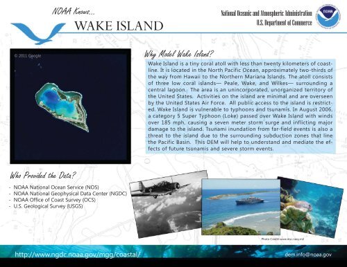
Wake Island is a tiny coral atoll with less than twenty kilometers of coastline.<br />
It is located in the North Pacific Ocean, approximately two-thirds of<br />
the way from Hawaii to the Northern Mariana Islands. The atoll consists<br />
of three low coral islands— Peale, Wake, and Wilkes— surrounding a<br />
central lagoon. The area is an unincorporated, unorganized territory of<br />
the United States. Activities on the island are minimal and are overseen<br />
by the United States Air Force. All public access to the island is restricted.<br />
Wake Island is vulnerable to typhoons and tsunamis. In August 2006,<br />
a category 5 Super Typhoon (Loke) passed over Wake Island with winds<br />
over 185 mph, causing a seven meter storm surge and inflicting major<br />
damage to the island. Tsunami inundation from far-field events is also a<br />
threat to the island due to the surrounding subduction zones that line<br />
the Pacific Basin. This DEM will help to understand and mediate the effects<br />
of future tsunamis and severe storm events.<br />
Photo Credit: www.msc.navy.mil<br />
http://www.ngdc.noaa.gov/mgg/coastal/ dem.info@noaa.gov