

Storm surges and coastal erosion in Bangladesh - State of ... - WMO
Storm surges and coastal erosion in Bangladesh - State of ... - WMO
Storm surges and coastal erosion in Bangladesh - State of ... - WMO

You also want an ePaper? Increase the reach of your titles
YUMPU automatically turns print PDFs into web optimized ePapers that Google loves.
<strong>Storm</strong> <strong>surges</strong> <strong>and</strong> <strong>coastal</strong> <strong>erosion</strong> <strong>in</strong> <strong>Bangladesh</strong> -<br />
<strong>State</strong> <strong>of</strong> the system, climate change impacts <strong>and</strong> 'low<br />
regret' adaptation measures<br />
By:<br />
Mohammad Mahtab Hossa<strong>in</strong><br />
Master Thesis<br />
Master <strong>of</strong> Water Resources <strong>and</strong> Environmental Management<br />
at<br />
Leibniz Universität Hannover<br />
Franzius-Institute <strong>of</strong> Hydraulic, Waterways <strong>and</strong> Coastal Eng<strong>in</strong>eer<strong>in</strong>g, Faculty <strong>of</strong><br />
Civil Eng<strong>in</strong>eer<strong>in</strong>g <strong>and</strong> Geodetic Science<br />
Advisor: Dipl.-Ing. Knut Kraemer<br />
Exam<strong>in</strong>ers:<br />
Pr<strong>of</strong>. Dr.-Ing. habil. T. Schlurmann<br />
Dr.-Ing. N. Goseberg<br />
Submission date:<br />
13.09.2012
Pr<strong>of</strong>. Dr. Torsten Schlurmann<br />
Manag<strong>in</strong>g Director & Chair<br />
Franzius-Institute for Hydraulic, Waterways <strong>and</strong> Coastal Eng<strong>in</strong>eer<strong>in</strong>g<br />
Leibniz Universität Hannover<br />
Nienburger Str. 4,<br />
30167 Hannover<br />
GERMANY<br />
Master thesis description for Mr. Mahtab Husse<strong>in</strong><br />
<strong>Storm</strong> <strong>surges</strong> <strong>and</strong> <strong>coastal</strong> <strong>erosion</strong> <strong>in</strong> <strong>Bangladesh</strong> - <strong>State</strong> <strong>of</strong> the system,<br />
climate change impacts <strong>and</strong> 'low regret' adaptation measures<br />
The effects <strong>of</strong> global environmental change, <strong>in</strong>clud<strong>in</strong>g <strong>coastal</strong> flood<strong>in</strong>g stemm<strong>in</strong>g<br />
from storm <strong>surges</strong> as well as reduced ra<strong>in</strong>fall <strong>in</strong> dryl<strong>and</strong>s <strong>and</strong> water<br />
scarcity, have detrimental effects on countries <strong>and</strong> megacities <strong>in</strong> the costal<br />
regions worldwide. Among these, <strong>Bangladesh</strong> with its capital Dhaka is today<br />
widely recognised to be one <strong>of</strong> the regions most vulnerable to climate change<br />
<strong>and</strong> its triggered associated impacts.<br />
Natural hazards that come from <strong>in</strong>creased ra<strong>in</strong>fall, ris<strong>in</strong>g sea levels, <strong>and</strong><br />
tropical cyclones are expected to <strong>in</strong>crease as climate changes, each seriously<br />
affect<strong>in</strong>g agriculture, water & food security, human health <strong>and</strong> shelter. It<br />
is believed that <strong>in</strong> the com<strong>in</strong>g decades the ris<strong>in</strong>g sea level alone <strong>in</strong> parallel<br />
with more severe <strong>and</strong> more frequent storm <strong>surges</strong> <strong>and</strong> stronger <strong>coastal</strong> <strong>erosion</strong><br />
will create more than 20 million people to migrate with<strong>in</strong> <strong>Bangladesh</strong><br />
itself (Black et al., 2011). Moreover, <strong>Bangladesh</strong>’s natural water resources<br />
are to a large part contam<strong>in</strong>ated with arsenic contam<strong>in</strong>ants because <strong>of</strong> the<br />
high arsenic contents <strong>in</strong> the soil. Up to 77 million people are exposed to toxic<br />
arsenic from dr<strong>in</strong>k<strong>in</strong>g water (Reich, 2011).<br />
Given that background, the current MSc thesis should collect <strong>in</strong>dicators as<br />
well as assess <strong>and</strong> critically discuss the present <strong>and</strong> likely future state <strong>of</strong> the<br />
<strong>coastal</strong> system <strong>and</strong> establish strategies as well as solutions <strong>in</strong> regard to<br />
storm <strong>surges</strong> <strong>and</strong> <strong>coastal</strong> <strong>erosion</strong> effects <strong>in</strong> <strong>Bangladesh</strong>.<br />
Seite 1/5<br />
Hannover,<br />
15 March 2012<br />
Nienburger Str. 4<br />
30167 Hannover, Germany<br />
Ph. +49 (0)511 762-19021<br />
Fax +49 (0)511 762-4002<br />
schlurmann@fi.uni-hannover.de<br />
www.fi.uni-hannover.de
Master thesis description for Mr. Mahtab Husse<strong>in</strong><br />
<strong>Storm</strong> <strong>surges</strong> <strong>and</strong> <strong>coastal</strong> <strong>erosion</strong> <strong>in</strong> <strong>Bangladesh</strong> - <strong>State</strong> <strong>of</strong> the system climate<br />
change impacts <strong>and</strong> 'low regret' adaptation measures<br />
In order to conduct a holistic overview <strong>of</strong> the state <strong>of</strong> the system, possible<br />
climate change impacts <strong>and</strong> possible 'low regret' adaptation measures with<br />
special emphasis on storm <strong>surges</strong> <strong>and</strong> <strong>coastal</strong> <strong>erosion</strong> <strong>in</strong> <strong>Bangladesh</strong>, the<br />
thesis should encompass <strong>and</strong> take <strong>in</strong>to consideration the follow<strong>in</strong>g aspects:<br />
Description <strong>of</strong> the country <strong>Bangladesh</strong> <strong>in</strong> regard to the theme <strong>of</strong> the thesis,<br />
i.e. geography <strong>and</strong> climate, rough overview <strong>of</strong> economy <strong>and</strong> demographic<br />
structure.<br />
In-depth review <strong>of</strong> governmental structure <strong>in</strong>clud<strong>in</strong>g an <strong>in</strong>stitutional mapp<strong>in</strong>g<br />
(m<strong>and</strong>ate, experiences, capacities, etc.) <strong>of</strong> the most relevant <strong>in</strong>stitutions<br />
<strong>and</strong> governmental bodies, research <strong>in</strong>stitutes <strong>and</strong> universities <strong>in</strong><br />
<strong>Bangladesh</strong> related to Disaster Risk Reduction (DRR) <strong>and</strong> the Hyogo<br />
Framework for Action (HFA) <strong>in</strong> straight accordance to Djalante et al.<br />
(2012) carried out recently for Indonesia. Where are the miss<strong>in</strong>g l<strong>in</strong>ks <strong>and</strong><br />
what needs to be organized or tackled additionally?<br />
Disaster history <strong>and</strong> experiences: When <strong>and</strong> what has been affected <strong>in</strong><br />
the country <strong>and</strong> statistics <strong>of</strong> losses? What have been the lessons learned<br />
from these experiences? How <strong>and</strong> what experiences did federal government<br />
<strong>and</strong> local governments take action on creat<strong>in</strong>g “goog governance”<br />
structures <strong>in</strong> relation to climate change effects? What are the synergies <strong>in</strong><br />
regard <strong>of</strong> the preparation <strong>and</strong> strategies to global change?<br />
Summary <strong>of</strong> (jo<strong>in</strong>t) research projects <strong>and</strong> <strong>in</strong>ternational development <strong>in</strong>itiatives<br />
<strong>in</strong> <strong>Bangladesh</strong> or <strong>in</strong> particular <strong>in</strong> Dhaka, what has been <strong>in</strong> focus <strong>and</strong><br />
to which degree the results have been implemented <strong>in</strong>to preparedness or<br />
adaptation programmes concern<strong>in</strong>g DRR measures.<br />
Anticipated (direct) climate change impacts (Karim <strong>and</strong> Mimura, 2008;<br />
Madsen <strong>and</strong> Jakobsen, 2004), effects <strong>of</strong> SLR related to exposure <strong>and</strong> vulnerability<br />
<strong>of</strong> the people <strong>and</strong> assets. What elements are at risk?<br />
Anticipated (<strong>in</strong>direct) climate change related impacts concern<strong>in</strong>g storm<br />
<strong>surges</strong>, <strong>and</strong> <strong>in</strong> consequences local sea states <strong>and</strong> wave action regard<strong>in</strong>g<br />
Seite 2/5
Master thesis description for Mr. Mahtab Husse<strong>in</strong><br />
<strong>Storm</strong> <strong>surges</strong> <strong>and</strong> <strong>coastal</strong> <strong>erosion</strong> <strong>in</strong> <strong>Bangladesh</strong> - <strong>State</strong> <strong>of</strong> the system climate<br />
change impacts <strong>and</strong> 'low regret' adaptation measures<br />
<strong>coastal</strong> <strong>erosion</strong> (now <strong>and</strong> then). Set-up <strong>and</strong> calibration <strong>of</strong> <strong>coastal</strong> see<br />
wave atlas by means <strong>of</strong> phase-averag<strong>in</strong>g model (SWAN) <strong>in</strong> order to <strong>in</strong>tegrate<br />
current sea states <strong>and</strong> future projections <strong>of</strong> wave action to derive a<br />
trustworthy data base for the coastl<strong>in</strong>e <strong>and</strong> estuaries <strong>of</strong> <strong>Bangladesh</strong>.<br />
Tentative adaptation measures <strong>in</strong> relation to recent SREX report <strong>and</strong><br />
possible solutions encompass<strong>in</strong>g so-called "low-regret" adaptation measures<br />
(technically, politically <strong>and</strong> socially) recently def<strong>in</strong>ed with<strong>in</strong> the IPCC-<br />
Special Report Manag<strong>in</strong>g the Risks <strong>of</strong> Extreme Events <strong>and</strong> Disasters to<br />
Advance Climate Change Adaptation (SREX)<br />
From the work flow listed above, ma<strong>in</strong> scientific emphasis might be put on<br />
the part consider<strong>in</strong>g the <strong>coastal</strong> see wave atlas <strong>and</strong> is expected to account<br />
for about one third <strong>of</strong> the given work<strong>in</strong>g time <strong>of</strong> six months <strong>of</strong> the thesis. For<br />
complet<strong>in</strong>g this particular task apart from the other more literature review<br />
work, computational power as well as versions <strong>of</strong> SWAN, MATLAB <strong>and</strong> ArcGis<br />
will be made available for the student under supervision <strong>of</strong> the depicted<br />
exam<strong>in</strong>ers <strong>and</strong> advisor.<br />
Three pr<strong>in</strong>ted versions <strong>of</strong> the thesis have to be delivered along with the digital<br />
thesis <strong>and</strong> a well-arranged work data archive. The data archive has to<br />
conta<strong>in</strong> all raw data, all used computational <strong>and</strong> MATLAB rout<strong>in</strong>es, simulation<br />
<strong>in</strong>put files <strong>of</strong> all presented simulation runs together with the MATLAB<br />
post-process<strong>in</strong>g rout<strong>in</strong>es <strong>and</strong> plots.<br />
The arrang<strong>in</strong>g <strong>of</strong> the rout<strong>in</strong>es for later work <strong>and</strong> the documentation <strong>of</strong> the<br />
work flow is part <strong>of</strong> the work <strong>and</strong> will thus be taken <strong>in</strong>to account for the grad<strong>in</strong>g.<br />
After the thesis is delivered, it will be presented <strong>in</strong> a talk with follow<strong>in</strong>g<br />
discussion <strong>of</strong> 30 m<strong>in</strong>utes to the exam<strong>in</strong>ers <strong>and</strong> advisor.<br />
Seite 3/5
Master thesis description for Mr. Mahtab Husse<strong>in</strong><br />
<strong>Storm</strong> <strong>surges</strong> <strong>and</strong> <strong>coastal</strong> <strong>erosion</strong> <strong>in</strong> <strong>Bangladesh</strong> - <strong>State</strong> <strong>of</strong> the system climate<br />
change impacts <strong>and</strong> 'low regret' adaptation measures<br />
Literature<br />
Black et al., Migration as adaptation, NATURE, VOL 478, 2011, p. 449<br />
Djalante, R., Thomalla, F., S<strong>in</strong>apoy, M.S., Carnegie, M., Build<strong>in</strong>g resilience to<br />
natural hazards <strong>in</strong> Indonesia: progress <strong>and</strong> challenges <strong>in</strong> implement<strong>in</strong>g the<br />
Hyogo Framework for Action, Natural Hazards, 2012, pp. 1-25.<br />
Karim, M.F., Mimura, N., Impacts <strong>of</strong> climate change <strong>and</strong> sea-level rise on<br />
cyclonic storm surge floods <strong>in</strong> <strong>Bangladesh</strong>, Global Environmental Change,<br />
2008, Vol. 18 (3), pp. 490-500.<br />
Madsen, H., Jakobsen, F., Cyclone <strong>in</strong>duced storm surge <strong>and</strong> flood forecast<strong>in</strong>g<br />
<strong>in</strong> the northern Bay <strong>of</strong> Bengal, Coastal Eng<strong>in</strong>eer<strong>in</strong>g, 2004, Vol. 51 (4), pp.<br />
277-296.<br />
Murty, T.S., Flather, R.A., Henry, R.F., The storm surge problem <strong>in</strong> the Bay<br />
<strong>of</strong> Bengal, Progress <strong>in</strong> Oceanography, 1986, Vol. 16 (4), pp. 195-233.<br />
Reich, S., Conflict<strong>in</strong>g studies fuel arsenic debate, NATURE, VOL 478, 2011,<br />
p. 437<br />
IPCC-SREX, Manag<strong>in</strong>g the Risks <strong>of</strong> Extreme Events <strong>and</strong> Disasters to Advance<br />
Climate Change Adaptation, Summary for policy makers, 2011<br />
http://ipcc-wg2.gov/SREX/<br />
Date <strong>of</strong> issue: 15 th March 2012 Clos<strong>in</strong>g date: 14 th September 2012<br />
1. Exam<strong>in</strong>er<br />
Pr<strong>of</strong>. Dr.-Ing. habil. T. Schlurmann<br />
Advisor<br />
Dipl.-Ing. Knut Kraemer<br />
Seite 4/5<br />
2. Exam<strong>in</strong>er<br />
Dr.-Ing. N. Goseberg
Master thesis description for Mr. Mahtab Husse<strong>in</strong><br />
<strong>Storm</strong> <strong>surges</strong> <strong>and</strong> <strong>coastal</strong> <strong>erosion</strong> <strong>in</strong> <strong>Bangladesh</strong> - <strong>State</strong> <strong>of</strong> the system climate<br />
change impacts <strong>and</strong> 'low regret' adaptation measures<br />
Seite 5/5
ACKNOWLEDGEMENT<br />
This thesis work has been done accord<strong>in</strong>g to the requirement <strong>of</strong> the Master <strong>of</strong> Science degree<br />
<strong>of</strong> Water Resources <strong>and</strong> Environmental Management (WATENV), Faculty <strong>of</strong> Civil<br />
Eng<strong>in</strong>eer<strong>in</strong>g at Leibniz University Hannover, Germany. First <strong>of</strong> all, I give thanks to almighty<br />
Allah (God) who has given me the ability to complete the tasks. After that, I would like to<br />
express my s<strong>in</strong>cere gratitude to my advisor, Dipl.-Ing. Knut Kraemer <strong>and</strong> exam<strong>in</strong>ers Dr.-Ing.<br />
N. Goseberg <strong>and</strong> Pr<strong>of</strong>. Dr.-Ing. habil. T. Schlurmann for their guidance, valuable suggestions,<br />
<strong>and</strong> <strong>in</strong>sightful comments on my work. Special thanks to Dipl.-Ing. Nils Kerpen, who provided<br />
me an electronic key to work at the Franzius CIP-Pool at any time.<br />
I would like to express my appreciation to <strong>Bangladesh</strong> Meteorological Department (BMD)<br />
<strong>and</strong> <strong>Bangladesh</strong> Water Development Board (BWDB) for their help with data provision which<br />
was very vital for the completion <strong>of</strong> the required tasks.<br />
I am grateful to World Meteorological Organization (<strong>WMO</strong>) for provid<strong>in</strong>g f<strong>in</strong>ancial support<br />
<strong>and</strong> for giv<strong>in</strong>g me the opportunity to participate <strong>in</strong> the WATENV course.<br />
I wish to extend my s<strong>in</strong>cere gratitude to my dearest friend Lojek Oliver, who generously made<br />
an effort to translate my abstract to German <strong>and</strong> Ellen Bonna who helped to check my<br />
grammatical errors.<br />
Last but not least, I would like to express my thanks to my family, wife, children, relatives,<br />
friends <strong>and</strong> my parents for their everlast<strong>in</strong>g support <strong>and</strong> patience.<br />
Thank you all, I am s<strong>in</strong>cerely grateful.<br />
Mohammad Mahtab Hossa<strong>in</strong><br />
Leibniz University Hannover, Germany<br />
September 2012<br />
i
ABSTRACT<br />
<strong>Bangladesh</strong> is vulnerable to several natural disasters. Tropical cyclones from the Bay <strong>of</strong><br />
Bengal accompanied by storm <strong>surges</strong> are one <strong>of</strong> the major disasters <strong>in</strong> <strong>Bangladesh</strong>. For many<br />
years, <strong>coastal</strong> <strong>erosion</strong> has been becom<strong>in</strong>g a regular natural phenomenon <strong>in</strong> <strong>Bangladesh</strong>. This<br />
study is ma<strong>in</strong>ly focused on the storm <strong>surges</strong> <strong>and</strong> <strong>coastal</strong> <strong>erosion</strong> hazard <strong>in</strong> <strong>Bangladesh</strong> with<br />
their adaptation measures consider<strong>in</strong>g the impact <strong>of</strong> current <strong>and</strong> future states <strong>of</strong> climate. Data<br />
has been collected from different <strong>in</strong>ternet sources <strong>and</strong> <strong>Bangladesh</strong> Meteorological Department<br />
(BMD) to model the <strong>coastal</strong> <strong>erosion</strong> by SWAN (Simulat<strong>in</strong>g <strong>of</strong> Waves Nearshore). SWAN is a<br />
widely used third generation wave model; however this study is the first for <strong>Bangladesh</strong>. The<br />
study concluded that, although <strong>Bangladesh</strong> has seriously addressed the Disaster Risk<br />
Reduction (DRR) <strong>and</strong> climate change issue there is still some commitment <strong>and</strong> capacities<br />
required to achieve DRR due to lack <strong>of</strong> resources <strong>and</strong> research work. Model<strong>in</strong>g by SWAN<br />
shows that the rate <strong>of</strong> <strong>erosion</strong> along the coast <strong>of</strong> <strong>Bangladesh</strong> <strong>in</strong>creases with the <strong>in</strong>creas<strong>in</strong>g<br />
w<strong>in</strong>d speed. The study also shows that the rate <strong>of</strong> <strong>erosion</strong> <strong>in</strong> 2030 <strong>and</strong> 2050 will be <strong>in</strong>creased<br />
due to sea level rise but it will not be <strong>in</strong>creased significantly. However, new areas <strong>in</strong> the coast<br />
will be <strong>in</strong>undated <strong>and</strong> affected by <strong>erosion</strong>.<br />
Key Words: Tropical Cyclones, Disaster, <strong>Storm</strong> Surges, Bay <strong>of</strong> Bengal, Adaptation, SWAN,<br />
Coastal Erosion.<br />
ii
ZUSAMMENFASSUNG<br />
Bangladesch wird durch diverse Umweltkatastrophen bedroht. Tropische Zyklone aus der<br />
Bucht von Bengalen begleitet durch Sturmfluten stellen mit e<strong>in</strong>e der schlimmsten<br />
Katastrophen dar. Küsten<strong>erosion</strong> ist seit vielen Jahren e<strong>in</strong> Phänomen mit dem Küstenstaaten<br />
wie Bangladesch zu kämpfen haben. Diese Arbeit beh<strong>and</strong>elt maßgeblich die Sturmfluten<br />
sowie die daraus resultierende Erosionsgefahr für die Küste <strong>in</strong> Bangladesch unter<br />
E<strong>in</strong>beziehung vorh<strong>and</strong>ener Schutzmaßnahmen unter derzeit vorherrschenden, sowie<br />
möglichen zukünftigen Klimae<strong>in</strong>flüssen. Die Studie stützt sich maßgeblich auf e<strong>in</strong>e<br />
Literaturrecherche. Daten wurden zum e<strong>in</strong>en von verschiedenen Internetquellen sowie dem<br />
<strong>Bangladesh</strong> Meteorological Department (BMD) zusammengetragen, um Küsten<strong>erosion</strong> mit<br />
der S<strong>of</strong>tware SWAN (Simulat<strong>in</strong>g Waves Near Shore) zu modellieren. SWAN, e<strong>in</strong><br />
Wellenmodell der dritten Generation, ist e<strong>in</strong> weit verbreitetes Programm das bereits zur<br />
Simulation von Seegangsverhältnissen <strong>in</strong> vielen komplexen Feld Studien auf der gesamten<br />
Welt e<strong>in</strong>gesetzt wurde. Die Simulation für die Küste von Bangladesch die <strong>in</strong> dieser Studie<br />
durchgeführt wurde, stellt jedoch e<strong>in</strong>e Primäre dar. Die Untersuchungen ergaben, dass<br />
Bangladesch sowohl Maßnahmen zur Katastrophenm<strong>in</strong>derung umgesetzt hat als auch den<br />
Klimaw<strong>and</strong>el ernst nimmt. Dennoch bestehen nach wie vor e<strong>in</strong> gewisses Restpotential zur<br />
Katastrophenm<strong>in</strong>derung, welches jedoch aufgrund mangelnder Ressourcen nicht voll<br />
ausgeschöpft werden kann. Die Simulation mit SWAN zeigte e<strong>in</strong>en Zusammenhang zwischen<br />
steigender Küsten<strong>erosion</strong> und zunehmenden W<strong>in</strong>dgeschw<strong>in</strong>digkeiten auf. Des Weiteren<br />
erlaubt die Simulation e<strong>in</strong>e Aussage über die zukünftige Entwicklung der Erosion zu tätigen.<br />
Demnach werden die Erosionsraten im Jahr 2030 sowie 2050 entlang der Küste aufgrund<br />
steigender Meeresspiegel nicht signifikant ansteigen. Allerd<strong>in</strong>gs deuten die Ergebnisse darauf<br />
h<strong>in</strong>, dass neue Gebiete im Inl<strong>and</strong> überflutet werden und von Erosion betr<strong>of</strong>fen se<strong>in</strong> könnten.<br />
iii
TABLE OF CONTENTS<br />
ACKNOWLEDGMENTS…………………………………………………………......... i<br />
ABSTRACT....................................................................................................................... ii<br />
ZUSAMMENFASSUNG.................................................................................................. iii<br />
TABLE OF CONTENTS………………………………………………………………… iv<br />
LIST OF TABLES ………………………………………………………………………. ix<br />
LIST OF FIGURES……………………………………………………………………... x<br />
LIST OF APPENDICES………………………………………………………………... xii<br />
ABBREVIATIONS & ACRONYMS…………………………………………………... xiii<br />
CHAPTER 1: INTRODUCTION…………………………………………… 1<br />
1.1 <strong>Bangladesh</strong> ……………………….………………………………………….. 1<br />
1.1.1 General Background……………………………………………………. 1<br />
1.1.2 Geography <strong>and</strong> Climate <strong>of</strong> <strong>Bangladesh</strong>………………………………….. 1<br />
1.1.3 Demographic, Economic, Social <strong>and</strong> Cultural Characteristics <strong>of</strong><br />
<strong>Bangladesh</strong>………………………………………………………………………. 3<br />
1.1.4 Governance Style <strong>of</strong> <strong>Bangladesh</strong>………………………………………... 4<br />
1.2 Natural Hazards <strong>in</strong> <strong>Bangladesh</strong>………..………………………………….. 5<br />
1.2.1 Cyclones <strong>and</strong> <strong>Storm</strong> Surges……………………………………………... 5<br />
1.2.2 Floods………………………………………………………………….... 6<br />
1.2.3 River Bank Erosion………………………………………………………. 6<br />
1.2.4 Coastal Erosion ………………………………………………………….. 6<br />
1.2.5 Earthquakes ………………………………………………………............ 6<br />
1.2.6 Droughts ………………………….…………………………………….... 7<br />
1.2.7 Tornados …………………………………………………………………. 7<br />
1.2.8 Arsenic Contam<strong>in</strong>ation………………………………………………….. 7<br />
1.2.9 Sal<strong>in</strong>ity Intrusion ………………………………………………………... 7<br />
1.3 Climate Change <strong>and</strong> Sea Level Rise <strong>in</strong> <strong>Bangladesh</strong>................................ 8<br />
iv
1.4 Objectives <strong>of</strong> the study work…………....................................................... 9<br />
1.5 Outl<strong>in</strong>e <strong>of</strong> the Report…………………..……............................................... 9<br />
CHAPTER 2: PHYSICAL PHENOMENA AND DISASTER RISK<br />
REDUCTION ………………………….…………………….……………………. 11<br />
2.1 Introduction ………………………………………………………………….. 11<br />
2.2 Cyclone <strong>and</strong> <strong>Storm</strong> Surges ………………………………………………... 11<br />
2.2.1 Introduc<strong>in</strong>g cyclones <strong>and</strong> storm <strong>surges</strong>....................................................... 11<br />
2.2.2 Classification <strong>of</strong> Cyclones …………………..………………………….. 12<br />
2.3 Waves <strong>in</strong> Coastal Areas ……………............................................................. 13<br />
2.3.1 Introduction …………………………………………………………….. 13<br />
2.3.2 W<strong>in</strong>d Generation <strong>in</strong> Coastal Areas……………………………………... 14<br />
2.3.3 White-Capp<strong>in</strong>g………………………………………………………….. 14<br />
2.3.4 Bottom Friction…………………………………………………………... 15<br />
2.3.5 Depth-Induced (Surf) Break<strong>in</strong>g………………………………………….. 17<br />
2.4 Term<strong>in</strong>ology on Disaster Risk Reduction................................................... 18<br />
2.5 Hyogo Framework for Action (HFA) 2005-2015………………………. 20<br />
CHAPTER 3: CLIMATE CHANGE IMPACTS, DISASTER<br />
HISTORY (STORM SURGES) AND EXPERIENCES IN<br />
BANGLADESH …………………………………………………………………. 22<br />
3.1 Introduction ………………………………………………………………….. 22<br />
3.2 Experiences from the Past Disasters (<strong>Storm</strong> Surges)…………….…... 22<br />
3.3 Climate Change Impacts <strong>in</strong> <strong>Bangladesh</strong> ……………….……………….. 26<br />
3.3.1 Climate Change Observed <strong>in</strong> <strong>Bangladesh</strong> ………..…………………….. 26<br />
3.3.2 Frequency <strong>and</strong> Intensity <strong>of</strong> Cyclone <strong>in</strong> Future <strong>in</strong> <strong>Bangladesh</strong> …………. 28<br />
3.3.3 Intensity <strong>of</strong> Impacts on different sectors due to Climate Change …..…... 28<br />
3.3.4 Actions <strong>in</strong> relation to climate change effects <strong>in</strong> <strong>Bangladesh</strong> ………….... 29<br />
3.4 <strong>Bangladesh</strong>’s Exposure <strong>and</strong> Vulnerability to Natural Hazards ……... 31<br />
v
3.4.1 Exposure <strong>in</strong> <strong>Bangladesh</strong> <strong>and</strong> Elements are at Risk …………………….. 31<br />
3.5.2 Vulnerability to Hazard Risks ………………………………………….. 32<br />
CHAPTER 4: IMPLEMENTATION OF DISASTER RISK<br />
REDUCTION PROGRAMMES - HYOGO FRAMEWORK FOR<br />
ACTION IN BANGLADESH ........................................................................ 34<br />
4.1 Disaster Management System <strong>in</strong> <strong>Bangladesh</strong> ……………………….. 34<br />
4.2 Institutional Mapp<strong>in</strong>g for Disaster Risk Reduction <strong>in</strong> <strong>Bangladesh</strong> ... 35<br />
4.2.1 Institutional L<strong>in</strong>kages ……………………………………………….….. 35<br />
4.2.2 Miss<strong>in</strong>g L<strong>in</strong>ks ……………………………………………………….….. 38<br />
4.3 National progress on the implementation <strong>of</strong> the Hyogo Framework for<br />
Action............................................................................................................................. 38<br />
4.3.1 Implementation <strong>of</strong> HFA Priorities for Action <strong>in</strong> <strong>Bangladesh</strong> ………….. 38<br />
4.3.2 Discussions <strong>and</strong> Recommendations on the Implementation <strong>of</strong> HFA <strong>in</strong><br />
<strong>Bangladesh</strong> ………………………………………………………………….….. 43<br />
4.4 Development Projects related to DRR <strong>in</strong> <strong>Bangladesh</strong> ………….…….. 46<br />
4.4.1 Key Donor Engagements ……………………………………………….. 46<br />
4.4.2 Situation <strong>of</strong> the Current Research ……………………………………….. 46<br />
4.4.3 Development Projects Related to DRR <strong>in</strong> <strong>Bangladesh</strong> ………………….. 47<br />
CHAPTER 5: MODEL SET-UP, CALIBRATION AND ANALYSIS<br />
OF EROSION ALONG BANGLADESH’S COAST ………………. 50<br />
5.1 Introduction ………………………………………………………………….. 50<br />
5.2 Available Data ………………………………………………………………. 50<br />
5.2.1 Bathymetry ……………………….…………………………………….. 50<br />
5.2.2 Tide <strong>and</strong> Current ………………………………………………….…….. 51<br />
5.2.3 Water Level …………………………………………………………….. 51<br />
5.2.4 W<strong>in</strong>d ……………………………………………………………………. 51<br />
5.2.5 Waves ……………………………………..……………………………. 52<br />
5.3 SWAN Model ………….………………………………………………….... 52<br />
vi
5.3.1 Co-ord<strong>in</strong>ate System <strong>in</strong> SWAN ……………………………………….... 53<br />
5.3.2 Grid System <strong>in</strong> SWAN ……………………………………………….... 53<br />
5.3.3 Boundary Conditions <strong>in</strong> SWAN ……………………………………….. 55<br />
5.4 Overall Model Set-up …….……………………………………………….. 55<br />
5.5 Sensitivity Analysis <strong>and</strong> Model Calibration …………..……………….. 56<br />
5.5.1 Sensitivity Analysis…………………………………………………..…. 56<br />
5.5.2 Model Calibration …………………….………………………….…….. 58<br />
5.6 Model Application to calculate the Erosion along <strong>Bangladesh</strong>’s<br />
Coast ………………………………………………………………………………….. 59<br />
5.6.1 Erosion at the Current Sea <strong>State</strong>s ……………………………………….. 62<br />
5.6.1.1 Discussion on the Erosion Scenarios for the Current Sea <strong>State</strong>s……....... 62<br />
5.6.1.2 Causes <strong>of</strong> Erosion <strong>in</strong> Coastal Waters……………………………………. 65<br />
5.6.1.3 Analysis <strong>of</strong> <strong>erosion</strong>s at different cross sections along the coast <strong>of</strong><br />
<strong>Bangladesh</strong> …………………………………………………………..…………. 66<br />
5.6.2 Comparison <strong>of</strong> Erosion Consider<strong>in</strong>g Climate Change …………………. 68<br />
5.6.2.1 Comparison <strong>of</strong> Erosion at Current Sea <strong>State</strong> regard<strong>in</strong>g Climate Change… 68<br />
5.6.2.2 Change <strong>in</strong> rate <strong>of</strong> Erosion due to Climate Change ………………………. 70<br />
5.6.2.3 Effects <strong>of</strong> SLR on Erosion ………………………………………………. 71<br />
CHAPTER 6: ADAPTATION MEASURES FOR EXTREME<br />
EVENTS MANAGEMENT …………………………………………………. 72<br />
6.1 Adaptation <strong>and</strong> Management for Chang<strong>in</strong>g Climate …………………. 72<br />
6.2 Low Regret Adaptation <strong>in</strong> <strong>Bangladesh</strong> ………………………………….. 73<br />
6.3 Costs <strong>of</strong> Adaptation Measures to Tropical Cyclones <strong>and</strong> <strong>Storm</strong><br />
Surges …………………………………………………………………………..…….. 76<br />
CHAPTER 7: CONCLUSIONS AND<br />
RECOMMENDATIONS…………………………………………….……….. 78<br />
7.1 Conclusions ……………………………………………………………….… 78<br />
7.2 Recommendations ……………………………………………………….… 79<br />
vii
REFERENCES ……………………………………………..……………..…….. 81<br />
APPENDICES ……..……………………………………………………….……. 86<br />
LIST OF FILES IN CD…………………………………………………….……. 105<br />
DECLARATION…..………………………………………………………….…. 106<br />
viii
LIST OF TABLES<br />
Table 1.1: The population statistics for <strong>Bangladesh</strong> accord<strong>in</strong>g to f<strong>in</strong>al census report (BBS,<br />
2011)………………………………………………………………………..……..…………….. 3<br />
Table 1.2: Economic status <strong>of</strong> <strong>Bangladesh</strong> (BTI, 2012)……………………………..………….. 4<br />
Table 1.3: The <strong>in</strong>undation scenarios <strong>in</strong> <strong>Bangladesh</strong> due to sea level rise (Ali, 1996)…………... 9<br />
Table 2.1: Classification <strong>of</strong> cyclones <strong>in</strong> South Asian Sub-Cont<strong>in</strong>ent (RRCAP, 2001) ………... 12<br />
Table 2.2: Classification <strong>of</strong> cyclonic disturbances presently <strong>in</strong> use by <strong>Bangladesh</strong> (<strong>WMO</strong>,<br />
2010)............................................................................................................................................ 13<br />
Table 2.3: The relative importance <strong>of</strong> the various processes <strong>in</strong> sea waters (Holthuijsen, 2007)<br />
………………………………………………………………………..…………………….…. 13<br />
Table 3.1: Trend <strong>of</strong> SLR along the coast <strong>of</strong> <strong>Bangladesh</strong> (S<strong>in</strong>gh, 2001) …………………….… 27<br />
Table 3.2: Impact <strong>of</strong> climate change on various sectors (MoEF, 2005) ………………………. 28<br />
Table 3.3: Typical scenarios <strong>in</strong> <strong>coastal</strong> zone (BBS, 2011) ..…………………………..………. 33<br />
Table 4.1: Some development projects that have been taken recently for disaster Management <strong>and</strong><br />
climate change adaptation (AKP, 2010)…………………………………..……..…………….. 47<br />
Table 4.2: Donor engagements <strong>and</strong> plans for medium to long-term (Year- 2022) disaster risk<br />
mitigation <strong>in</strong> <strong>Bangladesh</strong> (ISDR, 2009a) ………………………………………….……….. 48<br />
Table 5.1: Season wise maximum daily w<strong>in</strong>d speeds along <strong>Bangladesh</strong>’s coast dur<strong>in</strong>g 2001-2011<br />
………………………………………………………………………………………………..... 51<br />
Table 5.2: Recommended discretizations for spectral grid <strong>in</strong> SWAN…………………..….….. 55<br />
Table 5.3: The default sett<strong>in</strong>gs <strong>in</strong> SWAN that have been used <strong>in</strong> this project…………………. 56<br />
Table 5.4: Two boundary conditions for sensitivity analyses…………………………………... 57<br />
Table 5.5: The formulas <strong>and</strong> other required constant values that were used <strong>in</strong> SWAN………... 60<br />
Table 6.1: Adaptation cost to cyclone <strong>and</strong> storm <strong>surges</strong> by 2050 <strong>in</strong> <strong>Bangladesh</strong> (WB, 2010c)…. 76<br />
ix
LIST OF FIGURES<br />
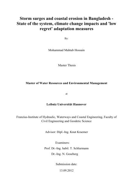
Figure 1.1: Three <strong>coastal</strong> regions <strong>in</strong> <strong>Bangladesh</strong>…………………………..……..…………….. 2<br />
Figure 1.2: Map <strong>of</strong> <strong>Bangladesh</strong> with some areas prone to a specific natural hazard..………….. 8<br />
Figure 2.1: <strong>Storm</strong> surge (wunderground.com)…………………………………………………... 12<br />
Figure 2.2: Transferr<strong>in</strong>g <strong>of</strong> w<strong>in</strong>d energy <strong>in</strong>to JONSWAP spectrum <strong>in</strong> deep <strong>and</strong> shallow water,<br />
( 3.5 m, <strong>and</strong> = 20 m/s) (Holthuijsen, 2007)……………………………... 14<br />
Figure 2.3: White-capp<strong>in</strong>g source term, <strong>in</strong> JONSWAP spectrum, <strong>in</strong> deep <strong>and</strong> shallow water,<br />
( =3.5 m <strong>and</strong> (Holthuijsen, 2007).......................................................................... 15<br />
Figure 2.4: The bottom friction dissipation <strong>in</strong>fluenced on JONSWAP spectrum, ( =3.5 m<br />
<strong>and</strong> (Holthuijsen, 2007) ……………………..………………….…………….…. 17<br />
Figure 2.5: The <strong>in</strong>fluence <strong>of</strong> surf-break<strong>in</strong>g on JONSWAP spectrum, ( =3.5 m <strong>and</strong><br />
(Holthuijsen, 2007)………………………………………………………………………….… 18<br />
Figure 3.1: Monthly distribution <strong>of</strong> recorded storm <strong>surges</strong> (Cyclones) <strong>in</strong> <strong>Bangladesh</strong> dur<strong>in</strong>g the period<br />
<strong>of</strong> 1584 to 2009 ……………………………………………………………………….………. 23<br />
Figure 3.2: Season wise distribution <strong>of</strong> cyclones that hit <strong>Bangladesh</strong> <strong>in</strong> year: 1584 - 2009…... 23<br />
Figure 3.3: Frequency <strong>of</strong> storm <strong>surges</strong> <strong>in</strong> <strong>Bangladesh</strong> <strong>in</strong> 10 year periods: 1890-2009 …….….. 24<br />
Figure 3.4: Different type <strong>of</strong> disturbances that hit <strong>Bangladesh</strong> <strong>in</strong> the period: 1890-2009……... 25<br />
Figure 3.5: Number <strong>of</strong> death due to super cyclonic storms that hit <strong>Bangladesh</strong> recently……... 25<br />
Figure 3.6: F<strong>in</strong>ancial damages due to super cyclonic storms that hit <strong>Bangladesh</strong> recently …... 26<br />
Figure 3.7: <strong>Bangladesh</strong>’s exposure <strong>and</strong> vulnerability to natural hazards (a) frequency <strong>of</strong> occurrence;<br />
(b) number <strong>of</strong> people died; (c) number <strong>of</strong> people affected; (d) vulnerability to cyclone hazard (Data<br />
from ISDR, 2009a; MoWCA, 2010) ………………………………………………………..... 31<br />
Figure 3.8: Area exposed to the Bay <strong>of</strong> Bengal <strong>in</strong> <strong>Bangladesh</strong> (Appendix 3.2) ……………... 32<br />
Figure 3.9: Comparions <strong>of</strong> population (a) density for whole country with <strong>coastal</strong> area only <strong>and</strong> (b)<br />
male to female ratio for whole country with <strong>coastal</strong> area only (BBS, 2011) …………….…... 33<br />
Figure 4.1: Disaster management system <strong>in</strong> <strong>Bangladesh</strong>……………….…..……………..….. 35<br />
Figure 4.2: Institutional (key governmental) map to reduce the risk <strong>of</strong> disaster <strong>in</strong><br />
<strong>Bangladesh</strong>………………………………………………………….………………………..... 37<br />
Figure 5.1: A graphical representation <strong>of</strong> bathymetry that is used <strong>in</strong> SWAN model…………... 50<br />
Figure 5.2: W<strong>in</strong>d stations that were considered to calculate the rate <strong>of</strong> <strong>erosion</strong> <strong>and</strong> different channels<br />
along the coast <strong>of</strong> <strong>Bangladesh</strong>………………………………………………………………...... 52<br />
Figure 5.3: Area, po<strong>in</strong>ts, <strong>and</strong> buoys that were used <strong>in</strong> SWAN……………………………...….. 57<br />
x
Figure 5.4: Comparison <strong>of</strong> SWAN outputs with forecasted data (a) at po<strong>in</strong>t-1; (b) at po<strong>in</strong>t-2 for Hs, (c)<br />
at po<strong>in</strong>t-1; (d) at po<strong>in</strong>t-2 for Tp, (e) at po<strong>in</strong>t-1; (f) at po<strong>in</strong>t-2 for wave direction……………..... 59<br />
Figure 5.5: Cross sections that were considered for comparison <strong>and</strong> analysis <strong>of</strong> <strong>erosion</strong> ……... 61<br />
Figure 5.6: Bottom level (a) along cross section A-A <strong>and</strong> B-B; (b) along cross section C-C…... 61<br />
Figure 5.7: Comparison <strong>of</strong> the rate <strong>of</strong> <strong>erosion</strong> us<strong>in</strong>g different bottom friction model along cross section<br />
(a) A-A; (b) B-B …………………………………………...…………………………………..... 62<br />
Figure 5.8: Erosion scenarios along the coast <strong>of</strong> <strong>Bangladesh</strong> at high tides for (a) 5 m/s western w<strong>in</strong>d;<br />
(b) 5 m/s southern w<strong>in</strong>d; (c) 10 m/s western w<strong>in</strong>d; (d) 10 m/s southern w<strong>in</strong>d; (e) 15 m/s southern w<strong>in</strong>d;<br />
(f) 20 m/s southern w<strong>in</strong>d; (g) 30 m/s southern w<strong>in</strong>d …………………………………….……... 64<br />
Figure 5.9: Wave orbital velocity with <strong>and</strong> without bottom friction along A-A (a) for 5 m/s w<strong>in</strong>d; (b)<br />
for 30 m/s w<strong>in</strong>d…………………………………………………………………….……….…... 65<br />
Figure 5.10: Erosion at current state due to different w<strong>in</strong>d, at high tides along (a) A-A; (b) B-B; (c) C-<br />
C; at Low tides along (d) A-A; (e) B-B; (f) C-C………………………………………………... 67<br />
Figure 5.11: Comparison <strong>of</strong> the rate <strong>of</strong> <strong>erosion</strong> at current state <strong>and</strong>, <strong>in</strong> 2030 along (a) A-A; (b) B-B; (c)<br />
C-C; <strong>in</strong> 2050 along (d) A-A; (e) B-B; (f) C-C………………………………………….……… 69<br />
Figure 5.12: Change <strong>in</strong> <strong>erosion</strong> due to 30 m/s w<strong>in</strong>d consider<strong>in</strong>g SLR along (a) A-A; (b) B-B; (c) C-<br />
C………………………………………………………………………………………………... 70<br />
Figure 5.13: Simplified model <strong>of</strong> l<strong>and</strong>ward <strong>coastal</strong> retreat under SLR (modified from UNEP,<br />
2010)…………………………………………………………………………………….….….. 71<br />
Figure 6.1: The approaches to adapt <strong>and</strong> manage for climate change (IPCC, 2012)…….….….. 72<br />
Figure 6.2: Cyclone <strong>and</strong> Flood <strong>in</strong>formation flows <strong>in</strong> <strong>Bangladesh</strong> (modified from UNEP,<br />
2010)……………………………………………………………………………………...….….. 74<br />
Figure 6.3: Closure dam under construction at Jamuna river, <strong>Bangladesh</strong> (UNEP,<br />
2010)…………………………………………………………………………………….………. 75<br />
Figure 6.4: Plantation <strong>of</strong> vetiver along polder (Islam, 2003)……………………………..….….. 76<br />
xi
LIST OF APPENDICES<br />
Appendix 3.1: Natural disasters (Cyclones/<strong>Storm</strong> Surges) <strong>in</strong> <strong>Bangladesh</strong> (Khan, 2012; SDC, 2010;<br />
RRCAP, 2001; Karim <strong>and</strong> Mimura, 2008; Murty et al., 1986; Ali, 1999; Choudhury et al., 1997;<br />
Shamsuddoha, 2008; BMD; Banglapedia; DMB)…………………………..……..…………….. 86<br />
Appendix 3.2: Districts <strong>and</strong> Upazilas <strong>of</strong> <strong>Bangladesh</strong>’s <strong>coastal</strong> zone (MoEF, 2007)..……….….. 90<br />
Appendix 3.3: Detailed damages by selected cyclones that hit <strong>Bangladesh</strong> recently (MoWCA, 2010;<br />
DMB)…………………………………………………………………………………………... 91<br />
Appendix 3.4A: Population census <strong>in</strong> <strong>Bangladesh</strong> (BBS, 2011) ………………………….…... 92<br />
Appendix 3.4B: Population census <strong>in</strong> <strong>Bangladesh</strong> (BBS, 2011)................................................... 93<br />
Appendix 3.5: Population <strong>and</strong> household scenarios <strong>in</strong> the <strong>coastal</strong> area <strong>of</strong> <strong>Bangladesh</strong> (BBS, 2011)<br />
………………………………………………………………………..…………………….…. 94<br />
Appendix 3.6: Population <strong>and</strong> households vulnerable to the natural hazards (BBS, 2011)….… 95<br />
Appendix 5.1: Tide levels that have been considered <strong>in</strong> SWAN model…………….…………. 96<br />
Appendix 5.2: Number <strong>of</strong> days <strong>of</strong> w<strong>in</strong>d blow<strong>in</strong>g from a direction along the coast <strong>of</strong> <strong>Bangladesh</strong> for the<br />
period 2001-2011 (BMD) ..……………………………………………………………..………. 98<br />
Appendix 5.3: The results <strong>of</strong> sensitivity analysis for different condition by us<strong>in</strong>g two boundary<br />
conditions (Table 5.4)………………………………..……………………..……..…………….. 99<br />
Appendix 5.4: The data that is considered for the model calibration <strong>and</strong> comparison <strong>of</strong> the results at<br />
po<strong>in</strong>t- 1 & 2 …………………………………………………………………………….……….. 100<br />
Appendix 5.5: SWAN calibration results <strong>and</strong> forecast<strong>in</strong>g data at po<strong>in</strong>t- 1& 2 for the period 08.06.12<br />
06:00 to 15.06.12 18:00………………………………………………………………………..... 101<br />
Appendix 5.6: The data which is used for model application at current satate…………..….….. 101<br />
Appendix 5.7: Significant wave height <strong>and</strong> wave period for different w<strong>in</strong>d speeds <strong>and</strong><br />
durations…………..………………………………………………………………………...….. 102<br />
Appendix 5.8: A typical comm<strong>and</strong> file for SWAN computation………………………..….….. 103<br />
Appendix 5.9: Critical bed shear <strong>of</strong> soil along the coast <strong>of</strong> <strong>Bangladesh</strong> (Barua et al., 1994)….. 104<br />
Appendix 5.10: Data has been used for the future projections along the coast <strong>of</strong> <strong>Bangladesh</strong>…. 104<br />
xii
ADB Asian Development Bank<br />
AFD Armed Forces Division<br />
ABBREVIATIONS & ACRONYMS<br />
BADC <strong>Bangladesh</strong> Agricultural Development Corporation<br />
BAU <strong>Bangladesh</strong> Agricultural University<br />
BBS <strong>Bangladesh</strong> Bureau <strong>of</strong> Statistics<br />
BCAS <strong>Bangladesh</strong> Centre for Advanced Studies<br />
BCCRF <strong>Bangladesh</strong> Climate Change Resilience Fund<br />
BCCSAP <strong>Bangladesh</strong> Climate Change Strategy <strong>and</strong> Action Plan<br />
BCS <strong>Bangladesh</strong> Civil Service<br />
BIDS <strong>Bangladesh</strong> Institute <strong>of</strong> Development Studies<br />
BIWTA <strong>Bangladesh</strong> Inl<strong>and</strong> Water Transport Authority<br />
BIWTC <strong>Bangladesh</strong> Inl<strong>and</strong> Water Transport Corporation<br />
BMD <strong>Bangladesh</strong> Meteorological Department<br />
BRAC <strong>Bangladesh</strong> Rural Advancement Committee<br />
BRRI <strong>Bangladesh</strong> Rice Research Institute<br />
BTRC <strong>Bangladesh</strong> Telecommunication Regulatory Commission<br />
BTV <strong>Bangladesh</strong> Television<br />
BUET <strong>Bangladesh</strong> University <strong>of</strong> Eng<strong>in</strong>eer<strong>in</strong>g <strong>and</strong> Technology<br />
BWDB <strong>Bangladesh</strong> Water Development Board<br />
CARE Co-operative for Assistance <strong>and</strong> Relief Everywhere<br />
CC Climate Change<br />
CBA Community Based Adaptation<br />
CCA Climate Change Adaptation<br />
CCC Climate Change Cell<br />
CCDMC City Corporation Disaster Management Committee<br />
CCF Climate Change Fund<br />
CDM Comprehensive Disaster Management<br />
CDMP Comprehensive Disaster Management Programme<br />
CEGIS Center for Environmental <strong>and</strong> Geographic Information Services<br />
CIDA Canadian International Development Agency<br />
COP Conference <strong>of</strong> Parties <strong>of</strong> UNFCCC<br />
CPP Cyclone Preparedness Programme<br />
CPPIB Cyclone Preparedness Program Implementation Board<br />
CRA Community Risk Assessment<br />
CSDDWS Committee for Speedy Dissem<strong>in</strong>ation <strong>of</strong> Disaster Related Warn<strong>in</strong>g/ Signals<br />
DAE Department <strong>of</strong> Agriculture Extension<br />
DANIDA Danish International Development Agency<br />
DC Deputy Commissioner<br />
xiii
DFID Department for International Development<br />
DG Director General<br />
DGoF Directorate General <strong>of</strong> Food<br />
DM Disaster Management<br />
DMA Disaster Management Act<br />
DMB Disaster Management Bureau<br />
DMC Disaster Management Committee<br />
DMIC Disaster Management Information Centre<br />
DMRD Disaster Management <strong>and</strong> Relief Division<br />
DMTATF Disaster Management Tra<strong>in</strong><strong>in</strong>g <strong>and</strong> Public Awareness Build<strong>in</strong>g Task Force<br />
DNA Damage <strong>and</strong> Need Assessment<br />
DoE Department <strong>of</strong> Environment<br />
DoH Directorate <strong>of</strong> Health<br />
DoRR Directorate <strong>of</strong> Relief <strong>and</strong> Rehabilitation<br />
DPHE Department <strong>of</strong> Public Health Eng<strong>in</strong>eer<strong>in</strong>g<br />
DRR Disaster Risk Reduction/Directorate <strong>of</strong> Relief <strong>and</strong> Rehabilitation<br />
DU Dhaka University<br />
EC European Commission<br />
ECNEC Executive Committee <strong>of</strong> the National Economic Council<br />
EGPP Employment Generation Programme for the Poorest<br />
EIA Environment Impact Assessment<br />
EOC Emergency Operation Centre<br />
EPAC Earthquake Preparedness <strong>and</strong> Awareness Committee<br />
ERD Economic Relations Division<br />
EU European Union<br />
FFW Food for Work<br />
FFWC Flood Forecast<strong>in</strong>g <strong>and</strong> Warn<strong>in</strong>g Centre<br />
FPOCG Focal Po<strong>in</strong>t Operation Coord<strong>in</strong>ation Group <strong>of</strong> Disaster Management<br />
FSCD Fire Service <strong>and</strong> Civil Defense<br />
GFDRR Global Facility for Disaster Reduction Recovery<br />
GoB Government <strong>of</strong> <strong>Bangladesh</strong><br />
GPWM Guidel<strong>in</strong>es for Participatory Water Management<br />
GSB Geological Survey <strong>of</strong> <strong>Bangladesh</strong><br />
HFA Hyogo Framework for Action<br />
ICDDR,B International Centre for Diarrhoeal Disease Research, <strong>Bangladesh</strong><br />
ICTs Information <strong>and</strong> Communication Technologies<br />
IDB Islamic Development Bank<br />
IMDMCC Inter-M<strong>in</strong>isterial Disaster Management Co-ord<strong>in</strong>ation Committee<br />
xiv
INGO International Non-Government Organization<br />
IPCC Inter-governmental Panel on Climate Change<br />
IUCN International Union for Conservation <strong>of</strong> Nature<br />
IWM Institute <strong>of</strong> Water Model<strong>in</strong>g<br />
IWRM Integrated Water Resource Management<br />
JBIC Japan Bank for International Cooperation<br />
JICA Japan International Cooperation Agency<br />
LACC Livelihood Adaptation to Climate Change<br />
LDC Least Developed Country<br />
LGD Local Government Division<br />
LGED Local Government Eng<strong>in</strong>eer<strong>in</strong>g Department<br />
LGI Local Government Institution<br />
MDG Millennium Development Goal<br />
MoA M<strong>in</strong>istry <strong>of</strong> Agriculture<br />
MoD M<strong>in</strong>istry <strong>of</strong> Defence<br />
MoEd M<strong>in</strong>istry <strong>of</strong> Education<br />
MoEF M<strong>in</strong>istry <strong>of</strong> Environment <strong>and</strong> Forests<br />
MoFA M<strong>in</strong>istry <strong>of</strong> Foreign Affairs<br />
MoFDM M<strong>in</strong>istry <strong>of</strong> Food <strong>and</strong> Disaster Management<br />
MoF&P M<strong>in</strong>istry <strong>of</strong> F<strong>in</strong>ance <strong>and</strong> Plann<strong>in</strong>g<br />
MoHA M<strong>in</strong>istry <strong>of</strong> Home Affairs<br />
MoHFW M<strong>in</strong>istry <strong>of</strong> Health <strong>and</strong> Family Welfare<br />
MoH&PW M<strong>in</strong>istry <strong>of</strong> Hous<strong>in</strong>g <strong>and</strong> Public Works<br />
MoI M<strong>in</strong>istry <strong>of</strong> Information<br />
MoLG&RD M<strong>in</strong>istry <strong>of</strong> Local Government, Rural Development <strong>and</strong> Cooperatives<br />
MoPME M<strong>in</strong>istry <strong>of</strong> Primary <strong>and</strong> Mass Education<br />
MoSh M<strong>in</strong>istry <strong>of</strong> Shipp<strong>in</strong>g<br />
MoS&T M<strong>in</strong>istry <strong>of</strong> Science <strong>and</strong> Information <strong>and</strong> Communication Technology<br />
MoWR M<strong>in</strong>istry <strong>of</strong> Water Resources<br />
MSL Mean Sea Level<br />
NAPA National Adaptation Programme <strong>of</strong> Action<br />
NBR National Board <strong>of</strong> Revenue<br />
NDMAC National Disaster Management Advisory Committee<br />
NDMC National Disaster Management Council<br />
NEC National Economic Council<br />
NFI Non-food items<br />
NGO Non-Government Organization<br />
NLUP National L<strong>and</strong>-Use Policy<br />
NPDM National Plan for Disaster Management<br />
xv
NPDRR National Platform for Disaster Risk Reduction<br />
OPEC Organization <strong>of</strong> the Petroleum Export<strong>in</strong>g Countries<br />
PDMC Pourashava Disaster Management Committee<br />
PRSP Poverty Reduction Strategy Paper<br />
PWD Public Works Department<br />
PMO Prime M<strong>in</strong>ister’s Office<br />
PSTU Patuakhali Science <strong>and</strong> Technology University<br />
RB <strong>Bangladesh</strong> Betar<br />
RF Ra<strong>in</strong>fall Station<br />
RRI River Research Institute<br />
RVCC Reduc<strong>in</strong>g Vulnerability to Climate Change project<br />
SAARC South Asian Association for Regional Cooperation<br />
SIDA Swedish International Development Authority<br />
SLR Sea Level Rise<br />
SOD St<strong>and</strong><strong>in</strong>g Orders on Disasters<br />
SPARRSO Space Research <strong>and</strong> Remote Sens<strong>in</strong>g Organization<br />
SST Sea Surface Temperature<br />
TBM Tidal Bas<strong>in</strong> Management<br />
TR Test Relief<br />
UDMC Union Disaster Management Committee<br />
UzDMC Upazila Disaster Management Committee<br />
UK United K<strong>in</strong>gdom<br />
UNDP United Nations Development Programme<br />
UNFCCC United Nations Framework Convention on Climate Change<br />
UN/ISDR United Nations International Strategy for Disaster Reduction<br />
UP Union Parishad<br />
UzP Upazila Parishad<br />
VGF Vulnerable Group Feed<strong>in</strong>g<br />
WB The World Bank<br />
WL Water Level Gauge<br />
<strong>WMO</strong> World Meteorological Organization<br />
Glossary<br />
Adivasi <strong>in</strong>digenous people<br />
Char low-ly<strong>in</strong>g river isl<strong>and</strong><br />
xvi
Parishad elected council for a local government (e.g. Union, Upazila, etc.)<br />
Pourashava urban local government meant for ‘Municipality’<br />
Union lowest tier <strong>of</strong> local government <strong>in</strong> <strong>Bangladesh</strong> comprised <strong>of</strong> a number <strong>of</strong> Wards<br />
Upazila lowest adm<strong>in</strong>istrative unit compris<strong>in</strong>g <strong>of</strong> a number <strong>of</strong> Unions<br />
xvii
1.1 <strong>Bangladesh</strong><br />
CHAPTER 1: INTRODUCTION<br />
1.1.1 General Background<br />
<strong>Bangladesh</strong> is recognized worldwide as one <strong>of</strong> the most vulnerable countries to natural<br />
disasters <strong>and</strong> to the impacts <strong>of</strong> global warm<strong>in</strong>g <strong>and</strong> climate change (SDC, 2010; DOE, 2007).<br />
Almost every year, <strong>Bangladesh</strong> experiences one or more disasters- such as tropical cyclones,<br />
storm <strong>surges</strong>, <strong>coastal</strong> <strong>erosion</strong>, floods, <strong>and</strong> droughts- result<strong>in</strong>g <strong>in</strong> massive loss <strong>of</strong> life <strong>and</strong><br />
property <strong>and</strong> hamper<strong>in</strong>g the development activities (Ali, 1999). “In 2004, the United Nations<br />
Development Programme (UNDP) ranked <strong>Bangladesh</strong> the number one nation at risk for<br />
tropical cyclones <strong>and</strong> number six for floods” (Luxbacher <strong>and</strong> Udd<strong>in</strong>, 2011). Rapid global<br />
warm<strong>in</strong>g has caused fundamental changes to <strong>Bangladesh</strong>’s climate <strong>and</strong> as a result millions are<br />
suffer<strong>in</strong>g (DOE, 2007). It is therefore necessary to underst<strong>and</strong> its vulnerability <strong>in</strong> terms <strong>of</strong><br />
population <strong>and</strong> sectors at risk <strong>and</strong> its potential for adaptation to climate change (DOE, 2006).<br />
Climate change is not only alter<strong>in</strong>g the disaster risk through <strong>in</strong>creased weather related risks,<br />
sea-level rise (SLR) <strong>and</strong> temperature <strong>and</strong> ra<strong>in</strong>fall variability, but also through <strong>in</strong>creases <strong>in</strong><br />
societal vulnerabilities from stresses on water availability, agriculture <strong>and</strong> ecosystems<br />
(MoFDM, 2009). In this context, one <strong>of</strong> the key issues <strong>in</strong> <strong>Bangladesh</strong> is to reduce the disaster<br />
risk. For this purpose, more comprehensive <strong>and</strong> systematic efforts at the <strong>in</strong>ternational,<br />
national <strong>and</strong> local levels are important to take <strong>in</strong>to account (Djalante et al., 2012). It was<br />
proved that disaster should be managed holistically from prevention, mitigation through to<br />
rehabilitation <strong>and</strong> reconstruction. Although global reduction <strong>of</strong> greenhouse gas emission (i.e.<br />
mitigation) is a must to overcome the challenge <strong>in</strong> the long-run, adaptation is a short-term but<br />
essential measure to tackle the climate change impact locally. Therefore, disaster risk<br />
reduction <strong>and</strong> climate change mitigation <strong>and</strong> adaptation provide a common area <strong>of</strong> concern:<br />
reduc<strong>in</strong>g the vulnerability <strong>of</strong> communities <strong>and</strong> achiev<strong>in</strong>g susta<strong>in</strong>able livelihood development<br />
(MoFDM, 2009).<br />
1.1.2 Geography <strong>and</strong> Climate <strong>of</strong> <strong>Bangladesh</strong><br />
<strong>Bangladesh</strong> is a low-ly<strong>in</strong>g deltaic country <strong>in</strong> South Asia, which is formed by the Ganges, the<br />
Brahmaputra <strong>and</strong> the Meghna rivers (DMB, 2010). <strong>Bangladesh</strong> is a develop<strong>in</strong>g country <strong>of</strong> low<br />
deltaic pla<strong>in</strong> located between 20°34ʹ to 26°38ʹ North latitude <strong>and</strong> 88°01ʹ to 92°42ʹ East<br />
longitude. The country occupies an area <strong>of</strong> 147,570 sq. km. (BBS, 2011). Its maximum<br />
extension is about 440 km <strong>in</strong> E-W direction whereas 760 km <strong>in</strong> N-S direction (Hoque, 2006).<br />
<strong>Bangladesh</strong> is located at the <strong>in</strong>terface <strong>of</strong> two quite different sett<strong>in</strong>gs. To the north <strong>of</strong> the<br />
country lie the Himalayas foot pla<strong>in</strong> <strong>and</strong> the Khasi-Ja<strong>in</strong>ta hills, <strong>and</strong> to the south are the Bay <strong>of</strong><br />
Bengal <strong>and</strong> the Indian Ocean. Those different sett<strong>in</strong>gs control, modify, <strong>and</strong> regulate the<br />
climate <strong>of</strong> the country (Ali, 1996). Geologically it is a part <strong>of</strong> the Bengal Bas<strong>in</strong>, which is built<br />
up by sediments washed down from the highl<strong>and</strong>s on three sides <strong>of</strong> it. It is bordered on the<br />
west, north <strong>and</strong> east by India, on the southeast by Myanmar (Karim <strong>and</strong> Mimura, 2006). The<br />
total length <strong>of</strong> the l<strong>and</strong> border <strong>of</strong> <strong>Bangladesh</strong> is about 4,246 km, <strong>of</strong> which 93.9% is shared<br />
with India <strong>and</strong> the rest with Myanmar (Hoque, 2006). There are 57 cross-boundary rivers, <strong>of</strong><br />
1
2<br />
Chapter 1<br />
which 54 are shared with India whereas other three rivers with Myanmar <strong>and</strong> <strong>Bangladesh</strong> is<br />
the common lower riparian zone <strong>of</strong> all these trans-boundary rivers (Chowdhury, 2010). There<br />
are more than 310 rivers <strong>and</strong> tributaries which have made this country a l<strong>and</strong> <strong>of</strong> rivers (DMB,<br />
2010).<br />
The <strong>coastal</strong> area represents an area <strong>of</strong> 47,201 km 2 , which is about 32% <strong>of</strong> <strong>Bangladesh</strong>’s total<br />
geographical area. In terms <strong>of</strong> adm<strong>in</strong>istrative consideration, 19 districts out <strong>of</strong> 64 are<br />
considered as <strong>coastal</strong> districts (BBS, 2011; MoEF, 2007). About 10% <strong>of</strong> the country is 1 m<br />
above the mean sea level, <strong>and</strong> one-third is under tidal excursions (Ali, 1999). The country has<br />
a coastl<strong>in</strong>e <strong>of</strong> about 710 km along the Bay <strong>of</strong> Bengal (MoWR, 2005). The country covers<br />
three discrete <strong>coastal</strong> regions - western, central, <strong>and</strong> eastern <strong>coastal</strong> zones which are shown <strong>in</strong><br />
Figure 1.1. The western part is known as the Ganges tidal pla<strong>in</strong>. Average l<strong>and</strong> elevation is<br />
below 1.5 m MSL. The southwestern part <strong>of</strong> the region is covered by the world’s largest<br />
mangrove forest (6017 km 2 ), popularly known as Sundarbans. The mangrove forests act as<br />
barriers to the furiousness <strong>of</strong> tropical cyclones <strong>and</strong> storm <strong>surges</strong>. Erosion is comparatively<br />
small <strong>in</strong> this region but it suffers from sal<strong>in</strong>ity <strong>and</strong> tidal flood<strong>in</strong>g (Karim <strong>and</strong> Mimura, 2006).<br />
The Sundarbans was declared by the UNESCO as a natural world heritage site <strong>in</strong> 1997 (Islam,<br />
2008). The central region is the most active one, <strong>and</strong> this area suffers from cont<strong>in</strong>uous <strong>erosion</strong><br />
<strong>and</strong> accretion (Karim <strong>and</strong> Mimura, 2006). The very active Meghna River estuary situates <strong>in</strong><br />
this region. The comb<strong>in</strong>ed flow <strong>of</strong> 3 powerful rivers – namely, the Ganges, the Brahmaputra,<br />
<strong>and</strong> the Meghna, are commonly called as the GBM river system <strong>and</strong> ranked as one <strong>of</strong> the<br />
largest river systems <strong>in</strong> the world - discharges with the name as Lower Meghna <strong>in</strong>to the<br />
northeastern corner <strong>of</strong> the Bay <strong>of</strong> Bengal. This estuarial region suffers from the most<br />
disastrous effects <strong>of</strong> tropical cyclones <strong>and</strong> storm <strong>surges</strong> <strong>in</strong> the world (Ali, 1999; Karim <strong>and</strong><br />
Mimura, 2006). The GBM river systems carry 85% <strong>of</strong> the total dry season flow pass<strong>in</strong>g<br />
through the <strong>coastal</strong> zone <strong>of</strong> <strong>Bangladesh</strong> (Islam, 2008). The eastern region has higher elevation<br />
<strong>and</strong> this zone is relatively stable part among other <strong>coastal</strong> regions <strong>in</strong> the country. The world<br />
longest natural beach (120 km) is situated <strong>in</strong> this region (Karim <strong>and</strong> Mimura, 2006).<br />
89°0'0"E<br />
89°0'0"E<br />
90°0'0"E<br />
90°0'0"E<br />
91°0'0"E<br />
91°0'0"E<br />
92°0'0"E<br />
23°0'0"N 23°0'0"N<br />
Char Changa<br />
22°0'0"N 22°0'0"N<br />
Hiron Po<strong>in</strong>t<br />
Western Region<br />
Central Region<br />
Eastern Region<br />
Cox's Bazar<br />
21°0'0"N<br />
Bay <strong>of</strong> Bengal<br />
21°0'0"N<br />
92°0'0"E<br />
Figure 1.1: Three <strong>coastal</strong> regions <strong>in</strong> <strong>Bangladesh</strong>
3<br />
Chapter 1<br />
<strong>Bangladesh</strong> is an agro-based country (Habib, 2011). It has subtropical monsoon climates<br />
which have wide seasonal variations <strong>in</strong> ra<strong>in</strong>fall, moderately warm temperatures, <strong>and</strong> high<br />
humidity (Hoque, 2006).<br />
The climate <strong>of</strong> <strong>Bangladesh</strong> can be classified under the follow<strong>in</strong>g four seasons:<br />
The first is W<strong>in</strong>ter or Northeast Monsoon (December to February): maximum temperature is<br />
31.1°C whereas occasional m<strong>in</strong>imum is 5°C with mean temperature is 18-21°C <strong>and</strong> average<br />
ra<strong>in</strong>fall is about 1.5% <strong>of</strong> the total annual ra<strong>in</strong>fall. The second is Summer or Pre-Monsoon<br />
(March to May): mean temperature is 23-30°C which occasionally rises 40.6°C <strong>and</strong> average<br />
ra<strong>in</strong>fall is 17% <strong>of</strong> the total annual ra<strong>in</strong>fall. The third is Southwest Monsoon or Monsoon (June<br />
to September): monsoon is both hot as well as humid <strong>and</strong> average ra<strong>in</strong>fall is about 72.5% <strong>of</strong><br />
the total annual ra<strong>in</strong>fall. The fourth is Autumn or Post-Monsoon (October <strong>and</strong> November):<br />
short-liv<strong>in</strong>g season, average ra<strong>in</strong>fall receives is about 9% <strong>of</strong> the total annual ra<strong>in</strong>fall (Habib,<br />
2011; DOE, 2006). The mean annual ra<strong>in</strong>fall is about 2300 mm whereas the average annual<br />
ra<strong>in</strong>fall varies from 1,200 mm <strong>in</strong> the extreme west to over 5,000 mm <strong>in</strong> the northeast (DOE,<br />
2006).<br />
1.1.3 Demographic, economic, social <strong>and</strong> cultural characteristics <strong>of</strong> <strong>Bangladesh</strong><br />
<strong>Bangladesh</strong> is a unitary, <strong>in</strong>dependent <strong>and</strong> sovereign republic called the People’s Republic <strong>of</strong><br />
<strong>Bangladesh</strong>. <strong>Bangladesh</strong> became an <strong>in</strong>dependent country on March 26, 1971 by the liberation<br />
war aga<strong>in</strong>st Pakistan, which ended on 16 December 1971 with the victory <strong>of</strong> <strong>Bangladesh</strong><br />
forces <strong>and</strong> the surrender <strong>of</strong> the occupy<strong>in</strong>g Pakistani Army. <strong>Bangladesh</strong> was under Muslim rule<br />
for five <strong>and</strong> a half centuries <strong>and</strong> entered <strong>in</strong>to British rule <strong>in</strong> 1757. At the time <strong>of</strong> the British<br />
rule, it was a part <strong>of</strong> the British Indian prov<strong>in</strong>ce <strong>of</strong> Bengal <strong>and</strong> Assam. In August 1947, it<br />
achieved <strong>in</strong>dependence from British rule along with the rest <strong>of</strong> India <strong>and</strong> formed a part <strong>of</strong><br />
Pakistan known as East Pakistan until it became <strong>in</strong>dependent on 16 December 1971 (Dhaka,<br />
2006).<br />
Table 1.1: The population statistics for <strong>Bangladesh</strong> accord<strong>in</strong>g to f<strong>in</strong>al census report (BBS, 2011)<br />
Area (147570 km 2 ) Male Female Population<br />
Total Population<br />
Density/km 2<br />
Total Average Annual<br />
Households Growth Rate %<br />
144,043697 72,109796 71,933901 976 32,173630 1.37<br />
Yearly Growth<br />
Rate %<br />
1974 (-) 1981 (2.32) 1991 (2.01) 2001 (1.58) 2011 (1.37)<br />
Table 1.1 shows that the total number <strong>of</strong> households is more than 32 million <strong>and</strong> population<br />
density is 976, which makes <strong>Bangladesh</strong> one <strong>of</strong> the most densely populated countries <strong>of</strong> the<br />
world. The number <strong>of</strong> male <strong>and</strong> female is about equal. Population annual growth rate shows a<br />
decreas<strong>in</strong>g trend from 2.32 <strong>in</strong> 1981 to 1.37 <strong>in</strong> 2011, which is about half.<br />
About 98% <strong>of</strong> <strong>Bangladesh</strong>i are ethnic Bengali <strong>and</strong> speak Bangla. Urdu-speak<strong>in</strong>g, non-Bengali<br />
Muslims <strong>of</strong> Indian orig<strong>in</strong>, <strong>and</strong> various tribal groups make up the rest. Ma<strong>in</strong>ly <strong>in</strong> urban areas,<br />
the educated people can speak English. Most <strong>of</strong> <strong>Bangladesh</strong>is (around 88.3%) are Muslims,<br />
but H<strong>in</strong>dus represent a m<strong>in</strong>ority. Small numbers <strong>of</strong> Buddhists, Christians, <strong>and</strong> animists are
4<br />
Chapter 1<br />
also present <strong>in</strong> <strong>Bangladesh</strong>. <strong>Bangladesh</strong> has a long <strong>and</strong> rich historical <strong>and</strong> cultural past, which<br />
comb<strong>in</strong>es Dravidian, Indo-Aryan, Mongol/Mughul, Arab, Persian, Turkic, <strong>and</strong> Western<br />
European cultures (Dhaka, 2006).<br />
Table 1.2: Economic status <strong>of</strong> <strong>Bangladesh</strong> (BTI, 2012)<br />
Economic Indicators 2007 2008 2009 2010<br />
GDP $ mn 68415.4 79554.4 89359.8 100357.0<br />
GDP Growth % 6.4 6.2 5.7 6.1<br />
Inflation (CPI) % 9.1 8.9 5.4 8.1<br />
Foreign Direct Investment % <strong>of</strong> GDP 1.0 1.3 0.8 1.0<br />
Export Growth % 13.0 7.0 0.0 0.9<br />
Import Growth % 16.0 -2.1 -2.6 0.7<br />
Current Account Balance $ mn 856.9 926.2 3556.1 2502.4<br />
Life Expectancy (68 Years) HDI (0.5)<br />
Poverty (Population liv<strong>in</strong>g on<br />
less than 2 $ a day) 81.3%<br />
Aid/Capita<br />
$7.6<br />
HDI Rank<br />
146 <strong>of</strong> 187<br />
G<strong>in</strong>i Index<br />
31.0<br />
Gender<br />
Inequality<br />
(0.55)<br />
UN Education<br />
Index (0.415)<br />
-<br />
GDP/Capita<br />
$1659<br />
- -<br />
Table 1.2 shows that the Gross Domestic Product (GDP) <strong>of</strong> <strong>Bangladesh</strong> is <strong>in</strong>creas<strong>in</strong>g <strong>and</strong> the<br />
growth rate <strong>of</strong> GDP is about 6% which is lower than the South Asian GDP growth rate (WB,<br />
2010a). The <strong>in</strong>flation rate is relatively higher <strong>in</strong> comparison with the developed countries but<br />
similar to other South Asian countries (WB, 2010a). Export <strong>and</strong> Import growth rates are<br />
show<strong>in</strong>g a decreas<strong>in</strong>g trend. The Human Development Index (HDI) is a complex statistic,<br />
which is used to rank countries by st<strong>and</strong>ard <strong>of</strong> liv<strong>in</strong>g. HDI <strong>of</strong> <strong>Bangladesh</strong> is 0.5 which<br />
<strong>in</strong>cludes the country as one <strong>of</strong> the low human development countries <strong>and</strong> ranked 146 out <strong>of</strong><br />
187 countries (UNDP, 2011). About 81.3% <strong>of</strong> populations, whose <strong>in</strong>come is less than 2 USD<br />
per person per day among whom about 34% live with less than 1 USD per person per day<br />
(SDC, 2010). Therefore, it is clear that a large number <strong>of</strong> populations <strong>in</strong> <strong>Bangladesh</strong> are liv<strong>in</strong>g<br />
below the poverty level which <strong>in</strong>dicates the severity <strong>of</strong> poverty or vulnerability <strong>in</strong><br />
<strong>Bangladesh</strong>.<br />
1.1.4 Governance Style <strong>of</strong> <strong>Bangladesh</strong><br />
The President <strong>in</strong> <strong>Bangladesh</strong>, who is the head <strong>of</strong> state but holds a largely ceremonial post<br />
because the president has limited adm<strong>in</strong>istrative power whereas the real power is held by the<br />
Prime M<strong>in</strong>ister, who is the head <strong>of</strong> the government. The President is elected by the legislature<br />
(Parliament) every five years. The President appo<strong>in</strong>ts the legislative, executive <strong>and</strong> the<br />
judiciary. The President also appo<strong>in</strong>ts the Prime M<strong>in</strong>ister who must be a Member <strong>of</strong><br />
Parliament (MP) <strong>and</strong> whom the President th<strong>in</strong>ks comm<strong>and</strong>s the confidence <strong>of</strong> the majority <strong>of</strong>
5<br />
Chapter 1<br />
other Members <strong>of</strong> Parliaments. The cab<strong>in</strong>et is formed <strong>of</strong> m<strong>in</strong>isters selected by the Prime<br />
M<strong>in</strong>ister but appo<strong>in</strong>ted by the President. At least 90% <strong>of</strong> the m<strong>in</strong>isters must be MPs whereas<br />
the other 10% can be non-MP experts, who are called "technocrats" but the rule is that<br />
technocrats are not otherwise disqualified from be<strong>in</strong>g elected MPs. The President can dissolve<br />
Parliament upon the written request <strong>of</strong> the Prime M<strong>in</strong>ister any time. The Parliament is<br />
unicameral, which is formed by 300 elected MPs by the people <strong>of</strong> <strong>Bangladesh</strong> by vote. Extra<br />
45 seats are reserved for women <strong>and</strong> to be distributed among political parties <strong>in</strong> proportion to<br />
their numerical strength <strong>in</strong> the Parliament (Dhaka, 2006).<br />
<strong>Bangladesh</strong>'s judiciary is a civil court system <strong>and</strong> it is still based on the British model. The<br />
highest court <strong>of</strong> appeal is the Appellate Bench <strong>of</strong> the Supreme Court. On the local government<br />
level, the country is separated <strong>in</strong>to divisions, districts (Zila), sub-districts (Upazila), unions,<br />
<strong>and</strong> villages. Local <strong>of</strong>ficials are elected at the union level <strong>and</strong> they are called Chairman. There<br />
is no election at the village level but members are selected by government. All larger<br />
adm<strong>in</strong>istrative units are conducted by the members <strong>of</strong> the civil service (Dhaka, 2006).<br />
1.2 Natural Hazards <strong>in</strong> <strong>Bangladesh</strong><br />
<strong>Bangladesh</strong> is exposed to a multitude <strong>of</strong> natural hazards with highly vary<strong>in</strong>g occurrence,<br />
season <strong>and</strong> extent <strong>of</strong> effects.<br />
1.2.1 Cyclones <strong>and</strong> <strong>Storm</strong> Surges<br />
Tropical cyclones accompanied by storm <strong>surges</strong> from the Bay <strong>of</strong> Bengal are one <strong>of</strong> the major<br />
disasters <strong>in</strong> <strong>Bangladesh</strong>. The country is one <strong>of</strong> the worst victims <strong>of</strong> all k<strong>in</strong>d <strong>of</strong> cyclonic<br />
casualties <strong>in</strong> the world (SDC, 2010). Damage to life <strong>and</strong> property due to cyclonic storms is<br />
enormous. In the <strong>coastal</strong> regions, the damage is ma<strong>in</strong>ly due to <strong>in</strong>duced storm <strong>surges</strong>,<br />
particularly over the low elevation <strong>coastal</strong> marg<strong>in</strong>s. This is why; the <strong>coastal</strong> zone <strong>of</strong><br />
<strong>Bangladesh</strong> could be termed a geographical "death trap" due to its extreme vulnerability to<br />
cyclones <strong>and</strong> storm <strong>surges</strong> (Shamsuddoha <strong>and</strong> Chowdhury, 2007). The massive loss <strong>of</strong> life by<br />
cyclone is due to the high density <strong>of</strong> population <strong>in</strong> this area, people liv<strong>in</strong>g <strong>in</strong> poverty with<strong>in</strong><br />
poorly constructed houses, the <strong>in</strong>adequate number <strong>of</strong> cyclone shelters, <strong>and</strong> the extremely lowly<strong>in</strong>g<br />
l<strong>and</strong> <strong>of</strong> the <strong>coastal</strong> zone (Ahmed, 1999). A UNDP report (titled ‘Reduc<strong>in</strong>g Risk <strong>of</strong><br />
Natural Disasters: A Development Challenge’) mentions that among the Asian countries<br />
<strong>Bangladesh</strong> is most highly prone to cyclonic disaster. The report also states that cyclone<br />
caused the death <strong>of</strong> 250 thous<strong>and</strong> people worldwide, <strong>of</strong> whom 60% were <strong>in</strong> <strong>Bangladesh</strong><br />
dur<strong>in</strong>g 1980 to 2000 (Shamsuddoha <strong>and</strong> Chowdhury, 2007). Although cyclones <strong>and</strong> floods<br />
have occurred <strong>in</strong> <strong>Bangladesh</strong> over the centuries, the damage is <strong>in</strong>creas<strong>in</strong>g due to grow<strong>in</strong>g<br />
population <strong>and</strong> <strong>in</strong>frastructure development <strong>in</strong> the <strong>coastal</strong> zone (Ahmed, 1999). Cyclones pose<br />
multiple threats from severe w<strong>in</strong>ds, storm <strong>surges</strong>, <strong>and</strong> heavy ra<strong>in</strong>fall that cause <strong>in</strong> both surface<br />
<strong>and</strong> river flood<strong>in</strong>g. Cyclones associated with tidal waves caused massive loss <strong>of</strong> lives <strong>and</strong><br />
property. Therefore, cyclonic storms have always been a major concern to <strong>coastal</strong> pla<strong>in</strong>s <strong>and</strong><br />
<strong>of</strong>fshore isl<strong>and</strong>s <strong>of</strong> <strong>Bangladesh</strong> (Shamsuddoha <strong>and</strong> Chowdhury, 2007).
Chapter 1<br />
1.2.2 Floods<br />
Floods are annual phenomena <strong>in</strong> <strong>Bangladesh</strong>. Normally the most severe floods occur dur<strong>in</strong>g<br />
the months <strong>of</strong> July <strong>and</strong> August (DMB, 2010). Regular river floods (dur<strong>in</strong>g monsoon season)<br />
affect 20% <strong>of</strong> the country which may <strong>in</strong>crease up to 67% <strong>in</strong> extreme years like the 1998 flood.<br />
The floods <strong>of</strong> 1988, 1998 <strong>and</strong> 2004 were simply disastrous (SDC, 2010).<br />
There are four types <strong>of</strong> flood <strong>in</strong> <strong>Bangladesh</strong> (DMB, 2010):<br />
Monsoon floods along major rivers dur<strong>in</strong>g the monsoon ra<strong>in</strong>s (June-September).<br />
Flash floods caused by overflow<strong>in</strong>g <strong>of</strong> hilly rivers <strong>of</strong> eastern <strong>and</strong> northern <strong>Bangladesh</strong><br />
(Normally dur<strong>in</strong>g April-May <strong>and</strong> September-November).<br />
Ra<strong>in</strong> floods caused by dra<strong>in</strong>age congestion dur<strong>in</strong>g heavy ra<strong>in</strong>s.<br />
Coastal floods caused by storm <strong>surges</strong>.<br />
1.2.3 River Bank Erosion<br />
River morphology <strong>in</strong> <strong>Bangladesh</strong> is highly dynamic. The ma<strong>in</strong> rivers are braided, <strong>and</strong> form<br />
isl<strong>and</strong>s (chars) between the braid<strong>in</strong>g channels. Many <strong>of</strong> these chars are highly unstable, "move<br />
with the flow" <strong>and</strong> are extremely sensitive to changes <strong>in</strong> the river morphology (SDC, 2010).<br />
Losses by river <strong>erosion</strong> happen slowly <strong>and</strong> gradually. Although losses due to river <strong>erosion</strong> are<br />
slow <strong>and</strong> gradual, they are more destructive <strong>and</strong> far-reach<strong>in</strong>g than other sudden <strong>and</strong><br />
devastat<strong>in</strong>g calamities. River <strong>erosion</strong> effects are long-term (DMB, 2010). Accord<strong>in</strong>g to the<br />
<strong>Bangladesh</strong> Water Development Board about 1,200 km <strong>of</strong> river banks are actively erodible<br />
(SDC, 2010).<br />
1.2.4 Coastal Erosion<br />
The natural shape <strong>of</strong> <strong>Bangladesh</strong> <strong>coastal</strong> <strong>and</strong> mar<strong>in</strong>e areas are controlled by dynamic<br />
processes such as tides, wave actions, strong w<strong>in</strong>ds <strong>and</strong> sea level variations. Over the last two<br />
centuries, huge changes have taken place due to cont<strong>in</strong>uous l<strong>and</strong> <strong>erosion</strong> <strong>and</strong> accretion along<br />
the coastl<strong>in</strong>e. This process is the most severe <strong>in</strong> the Meghna estuary (MoEF, 2007). The<br />
people <strong>in</strong> the <strong>coastal</strong> area are <strong>in</strong>creas<strong>in</strong>g <strong>and</strong> they are the worst victims. Studies expla<strong>in</strong> that<br />
major <strong>erosion</strong> occurs along the wider channels (Meghna estuary). Most <strong>of</strong> the <strong>erosion</strong> <strong>of</strong> the<br />
Bay <strong>of</strong> Bengal front was due to storm <strong>surges</strong> <strong>and</strong> cont<strong>in</strong>uous wave actions (Ahmed, 1999).<br />
The area <strong>of</strong> S<strong>and</strong>wip Isl<strong>and</strong>, for example, was 1,080 sq km <strong>in</strong> 1780, but now it has been<br />
reduced to only 238 km 2 <strong>and</strong> <strong>in</strong> Hatiya, <strong>erosion</strong> is tak<strong>in</strong>g place at the rate <strong>of</strong> 400 meter/year<br />
(Ahmed, 1999). Hatiya (Upazila, Noakhali District) has reduced from 1000 km 2 to only 21<br />
km 2 over 350 years whereas Sw<strong>and</strong>ip ( Upazila, Chittagong District) has lost 180 km 2 <strong>in</strong> the<br />
last 100 years. Kutubdia (Upazila, Cox's Bazar District) has reduced from 250 km 2 to only 60<br />
km 2 dur<strong>in</strong>g the period 1880 to 1980 by the process <strong>of</strong> strong tidal actions <strong>and</strong> cyclonic effects.<br />
Bhola (District) Isl<strong>and</strong> has been squeezed from 6400 km 2 to 3400 km 2 s<strong>in</strong>ce 1960. In each<br />
year the GMB river system carries 6 million cusecs <strong>of</strong> water with 2179 million metric tons <strong>of</strong><br />
sediment which causes water logg<strong>in</strong>g <strong>and</strong> flood<strong>in</strong>g <strong>in</strong> the monsoon period <strong>and</strong> is responsible<br />
for the accretion process <strong>in</strong> this area (Shamsuddoha <strong>and</strong> Chowdhury, 2007).<br />
1.2.5 Earthquakes<br />
<strong>Bangladesh</strong> <strong>and</strong> the north-eastern Indian states are one <strong>of</strong> the seismically active regions <strong>of</strong> the<br />
6
7<br />
Chapter 1<br />
world, <strong>and</strong> have experienced numerous large earthquakes dur<strong>in</strong>g the past 200 years (DMB,<br />
2010). Dur<strong>in</strong>g 1869-1930, five earthquakes with magnitude M≥7 have hit parts <strong>of</strong><br />
<strong>Bangladesh</strong>, out <strong>of</strong> which two had their epicenters <strong>in</strong>side <strong>Bangladesh</strong>. Although no major<br />
event occurred dur<strong>in</strong>g the last decades, seismicity is still high for <strong>Bangladesh</strong>. <strong>Bangladesh</strong><br />
University <strong>of</strong> Eng<strong>in</strong>eer<strong>in</strong>g <strong>and</strong> Technology (BUET) prepared a new seismic zon<strong>in</strong>g map <strong>and</strong><br />
recognized that 43% <strong>of</strong> the areas <strong>of</strong> <strong>Bangladesh</strong> are rated high risk, 41% moderate whereas<br />
16% at low risk (SDC, 2010).<br />
1.2.6 Droughts<br />
Droughts ma<strong>in</strong>ly occur <strong>in</strong> the western parts <strong>of</strong> <strong>Bangladesh</strong> (Rajshahi <strong>and</strong> Rangpur Division)<br />
<strong>and</strong> <strong>in</strong> the Chittagong Hill tracts area (SDC, 2010). <strong>Bangladesh</strong> is at high risk from droughts.<br />
Dur<strong>in</strong>g the period 1949 to 1991, <strong>Bangladesh</strong> faced droughts 24 times (DMB, 2010). In recent<br />
years, the frequency <strong>and</strong> <strong>in</strong>tensity <strong>of</strong> drought has been <strong>in</strong>creas<strong>in</strong>g cont<strong>in</strong>uously <strong>and</strong> affects the<br />
agricultural production, ma<strong>in</strong>ly rice (SDC, 2010).<br />
1.2.7 Tornados<br />
Tornados (It is called Kalbaishakhi <strong>in</strong> <strong>Bangladesh</strong>) are ma<strong>in</strong>ly occurr<strong>in</strong>g <strong>in</strong> two transitional<br />
periods (Pre-monsoon <strong>and</strong> Post-monsoon). They are suddenly formed <strong>and</strong> <strong>of</strong> brief duration<br />
<strong>and</strong> are extremely localized <strong>in</strong> nature. Therefore, it is very difficult to locate Tornados or<br />
forecast their occurrence with the available techniques at present. They may cause also a lot<br />
<strong>of</strong> havocs <strong>and</strong> destructions (SDC, 2010). S<strong>in</strong>ce <strong>in</strong>dependence <strong>in</strong> 1971, <strong>Bangladesh</strong> has<br />
experienced at least eight major tornados, killed on an average more than 100 people <strong>in</strong> each<br />
event <strong>and</strong> caused severe damage <strong>in</strong> their narrow paths (SDC, 2010).<br />
1.2.8 Arsenic Contam<strong>in</strong>ation<br />
Arsenic contam<strong>in</strong>ation is grow<strong>in</strong>g <strong>in</strong> <strong>Bangladesh</strong> <strong>and</strong> at present, it is considered to be a<br />
dangerous environmental threat as well as a serious health risk (contam<strong>in</strong>at<strong>in</strong>g dr<strong>in</strong>k<strong>in</strong>g<br />
water). It is def<strong>in</strong>ed as a public health emergency <strong>in</strong> <strong>Bangladesh</strong>. Although there are<br />
geological reasons (arsenic complexes present <strong>in</strong> soils), the excessive extraction <strong>of</strong> water for<br />
irrigation <strong>and</strong> domestic water supply have accelerated the problem (SDC, 2010). Ground<br />
water <strong>in</strong> 61 out <strong>of</strong> 64 districts <strong>in</strong> <strong>Bangladesh</strong> is contam<strong>in</strong>ated with arsenic. Accord<strong>in</strong>g to a<br />
study conducted by the British Geological Survey <strong>and</strong> DPHE, arsenic concentrations <strong>in</strong> the<br />
country range from less than 0.25 mg/l to more than 1600 mg/l (DMB, 2010).<br />
1.2.9 Sal<strong>in</strong>ity Intrusion<br />
Sal<strong>in</strong>e water <strong>in</strong>trusion is mostly seasonal <strong>in</strong> <strong>Bangladesh</strong>. Dur<strong>in</strong>g w<strong>in</strong>ter the sal<strong>in</strong>e front starts<br />
to penetrate <strong>in</strong>to <strong>in</strong>l<strong>and</strong>, <strong>and</strong> the affected areas rise sharply from 10% <strong>in</strong> the monsoon to over<br />
40% <strong>in</strong> the dry season. It is observed that dry water flow (Upstream) trend has decl<strong>in</strong>ed.<br />
Therefore, sea flow (sal<strong>in</strong>e water) is mov<strong>in</strong>g far <strong>in</strong>side the country caus<strong>in</strong>g <strong>in</strong> contam<strong>in</strong>ation<br />
both <strong>in</strong> surface <strong>and</strong> ground waters (DMB, 2010). It is measured that sal<strong>in</strong>e water <strong>in</strong>trusion has<br />
<strong>in</strong>creased which will be <strong>in</strong>tensified with the sea level rise. It is highly seasonal <strong>and</strong> affects<br />
crop productivity (SDC, 2010).
88°0'0"E<br />
88°0'0"E<br />
89°0'0"E<br />
89°0'0"E<br />
90°0'0"E<br />
90°0'0"E<br />
Figure 1.2: Map <strong>of</strong> <strong>Bangladesh</strong> with some areas prone to a specific natural hazard<br />
8<br />
91°0'0"E<br />
91°0'0"E<br />
92°0'0"E<br />
92°0'0"E<br />
93°0'0"E<br />
93°0'0"E<br />
Chapter 1<br />
26°0'0"N 26°0'0"N<br />
25°0'0"N 25°0'0"N<br />
24°0'0"N 24°0'0"N<br />
23°0'0"N 23°0'0"N<br />
22°0'0"N 22°0'0"N<br />
21°0'0"N 21°0'0"N<br />
Coastal Districts<br />
Flash Flood Prone Area<br />
Bay <strong>of</strong> Bengal<br />
20°0'0"N<br />
Drought Prone Area<br />
Flood Prone Area<br />
20°0'0"N<br />
1.3 Climate Change <strong>and</strong> Sea Level Rise <strong>in</strong> <strong>Bangladesh</strong><br />
Although the impacts <strong>of</strong> global warm<strong>in</strong>g <strong>and</strong> climate change are over the world, this problem<br />
is very high for <strong>Bangladesh</strong> because <strong>of</strong> the population is chronically exposed <strong>and</strong> vulnerable<br />
to a range <strong>of</strong> natural hazards. Climatic hazards, <strong>in</strong>clud<strong>in</strong>g extremes like floods, cyclones,<br />
tornado, storm <strong>surges</strong>, tidal bores, etc are not new but climate variability, change <strong>and</strong><br />
extremes <strong>in</strong> <strong>Bangladesh</strong> due to the effects <strong>of</strong> global warm<strong>in</strong>g have already been evidenced <strong>and</strong><br />
may <strong>in</strong>tensify the problems (DOE, 2007). <strong>Bangladesh</strong> is a low-lay<strong>in</strong>g deltaic country which<br />
will face the serious consequences due to sea level rise <strong>in</strong>clud<strong>in</strong>g permanent <strong>in</strong>undation <strong>of</strong><br />
huge l<strong>and</strong> masses along the coastl<strong>in</strong>e. There is a clear evidence <strong>of</strong> chang<strong>in</strong>g climate <strong>in</strong><br />
N
9<br />
Chapter 1<br />
<strong>Bangladesh</strong> which is result<strong>in</strong>g <strong>in</strong> changes <strong>in</strong> the precipitation, <strong>in</strong>creas<strong>in</strong>g annual mean<br />
temperature <strong>and</strong> sea level rise (Shamsuddoha <strong>and</strong> Chowdhury, 2007). It is projected that<br />
<strong>Bangladesh</strong> will be affected by sea level rise (SLR) <strong>in</strong> future which will be caused by a large<br />
<strong>coastal</strong> areas <strong>in</strong>undation (SDC, 2010).<br />
Table 1.3: The <strong>in</strong>undation scenarios <strong>in</strong> <strong>Bangladesh</strong> due to sea level rise (Ali, 1996)<br />
Sea Level Rise (m) Inundation (km 2 ) % <strong>of</strong> total area (<strong>Bangladesh</strong>)<br />
1.0 14,000 10.0<br />
1.5 22,320 15.5<br />
Table 1.3 shows the severity <strong>of</strong> SLR <strong>in</strong> <strong>Bangladesh</strong> <strong>in</strong> future. <strong>Bangladesh</strong> is a densely<br />
populated county. If it’s 10% or 15.5% area goes under water <strong>in</strong> future due to sea level rise,<br />
millions <strong>of</strong> people will migrate to <strong>in</strong>ner area <strong>of</strong> <strong>Bangladesh</strong> <strong>and</strong> the country will face acute<br />
problems.<br />
1.4 Objectives <strong>of</strong> the Study Work<br />
The study will focus on the disaster history <strong>and</strong> experience <strong>and</strong> the implementation <strong>of</strong> the<br />
Disaster Risk Reduction Progammes with mention<strong>in</strong>g <strong>of</strong> the relevant <strong>in</strong>stitutions <strong>in</strong><br />
<strong>Bangladesh</strong>. The study also will assess <strong>and</strong> critically discuss the present <strong>and</strong> likely future state<br />
<strong>of</strong> the <strong>coastal</strong> system (wave action regard<strong>in</strong>g <strong>coastal</strong> <strong>erosion</strong>) <strong>and</strong> focus on the adaptation<br />
measures with special emphasis on storm <strong>surges</strong> <strong>and</strong> <strong>coastal</strong> <strong>erosion</strong>. As a summary, the<br />
<strong>in</strong>vestigations, as the aims <strong>of</strong> the project are perused <strong>in</strong> this thesis are listed below:<br />
To <strong>in</strong>troduce <strong>Bangladesh</strong> <strong>in</strong> regard to geography, climate, economy, demographic<br />
structure, governance style along with vulnerability to natural hazards, sea level rise<br />
<strong>and</strong> climate change.<br />
To collect the Disaster (Cyclone) history <strong>in</strong> <strong>Bangladesh</strong> <strong>and</strong> expla<strong>in</strong> the lessons<br />
gathered by the experiences due to cyclones that hit <strong>Bangladesh</strong>.<br />
To develop an <strong>in</strong>stitutional map with most <strong>of</strong> the relevant <strong>in</strong>stitutions <strong>and</strong><br />
governmental bodies, research <strong>in</strong>stitutes <strong>and</strong> universities <strong>in</strong> <strong>Bangladesh</strong> related to<br />
Disaster Risk Reduction.<br />
To calculate the rate <strong>of</strong> <strong>erosion</strong> along the coast <strong>of</strong> <strong>Bangladesh</strong> due to wave actions<br />
over the years.<br />
To <strong>in</strong>vestigate the impact <strong>of</strong> climate change regard<strong>in</strong>g <strong>coastal</strong> <strong>erosion</strong> <strong>in</strong> <strong>Bangladesh</strong>.<br />
To mention the adaptation measures regard<strong>in</strong>g SREX report to manage the Extreme<br />
Events <strong>and</strong> Disasters due to climate change <strong>in</strong> <strong>Bangladesh</strong>.<br />
1.5 Outl<strong>in</strong>e <strong>of</strong> the Report<br />
The present report is arranged as follows:<br />
Chapter 1 conta<strong>in</strong>s the <strong>in</strong>troduction to <strong>in</strong>troduce <strong>Bangladesh</strong>.<br />
Chapter 2 conta<strong>in</strong>s the physical phenomena <strong>and</strong> disaster risk reduction term<strong>in</strong>ology.<br />
Chapter 3 collects the past recorded disaster histories (storm <strong>surges</strong>) <strong>and</strong> analyzes to<br />
gather the lessons.
10<br />
Chapter 1<br />
Disaster risk reduction system <strong>and</strong> an <strong>in</strong>stitutional map for disaster risk reduction <strong>in</strong><br />
<strong>Bangladesh</strong> are presented <strong>in</strong> Chapter 4. Achievements <strong>of</strong> <strong>Bangladesh</strong> <strong>in</strong> implement<strong>in</strong>g<br />
Hyogo Framework for Action are summarized <strong>and</strong> also discussed here. Few<br />
development projects for disaster risk reduction <strong>and</strong> climate change adaptation <strong>in</strong><br />
<strong>Bangladesh</strong> are also mentioned here.<br />
Chapter 5 conta<strong>in</strong>s the model<strong>in</strong>g part with the help <strong>of</strong> SWAN model to analyze the<br />
rate <strong>of</strong> <strong>erosion</strong> along the coast <strong>of</strong> <strong>Bangladesh</strong> at current <strong>and</strong> future climate projections.<br />
Chapter 6 presents the low regret adaptation measures <strong>in</strong> <strong>Bangladesh</strong> to manage the<br />
impacts <strong>of</strong> climate change <strong>in</strong> relation to SREX report.<br />
F<strong>in</strong>ally conclusion <strong>and</strong> recommendation will be provided <strong>in</strong> chapter 7.
CHAPTER 2: PHYSICAL PHENOMENA AND DISASTER<br />
RISK REDUCTION<br />
2.1 Introduction<br />
The coast <strong>of</strong> <strong>Bangladesh</strong> is a vulnerable zone prone to natural disasters like cyclone, storm<br />
surge, flood, <strong>erosion</strong>, etc. <strong>and</strong> it is also a zone <strong>of</strong> opportunities due to presence <strong>of</strong> many<br />
economic activities like <strong>coastal</strong> fisheries <strong>and</strong> shrimp, forest, salt <strong>and</strong> m<strong>in</strong>erals, harbors,<br />
airports, tourism complexes, etc. (MoWR, 2005). Cyclonic storms have always been a major<br />
concern to <strong>coastal</strong> pla<strong>in</strong>s <strong>and</strong> <strong>of</strong>fshore isl<strong>and</strong>s <strong>of</strong> <strong>Bangladesh</strong> <strong>and</strong> they also slow down the<br />
pace <strong>of</strong> social <strong>and</strong> economic developments <strong>in</strong> this region (MoWR, 2005). It is forecast that<br />
climate change will <strong>in</strong>crease the frequency <strong>and</strong> severity <strong>of</strong> tropical cyclones <strong>in</strong> <strong>Bangladesh</strong><br />
(Luxbacher <strong>and</strong> Udd<strong>in</strong>, 2011). River <strong>erosion</strong> <strong>and</strong> loss <strong>of</strong> <strong>coastal</strong> habitable <strong>and</strong> cultivable l<strong>and</strong><br />
is a severe national problem <strong>and</strong> another major natural hazard <strong>in</strong> <strong>Bangladesh</strong>. Although<br />
<strong>erosion</strong> does not cause loss <strong>of</strong> lives, it leads to huge economic losses, lessens people’s assets<br />
<strong>and</strong> mak<strong>in</strong>g them unable to set up roots (Shamsuddoha <strong>and</strong> Chowdhury, 2007).<br />
“DRR (Disaster Risk Reduction) is the development <strong>and</strong> application <strong>of</strong> policies <strong>and</strong> practices<br />
that m<strong>in</strong>imize risks to vulnerabilities <strong>and</strong> disasters” (MoFDM, 2009). Therefore, to reduce the<br />
vulnerability <strong>and</strong> disaster risk to natural hazard, DRR Programmes e.g. Hyogo Framework for<br />
Action (HFA) should be implemented.<br />
To predict the <strong>coastal</strong> <strong>erosion</strong> problem, a numerical model is necessary to simulate the wave<br />
actions along the coast <strong>of</strong> <strong>Bangladesh</strong>. Several aspects should be understood to simulate the<br />
wave. Additionally, scales, conditions, <strong>and</strong> data availabilities have to be determ<strong>in</strong>ed to<br />
approach the subject. In another words, the <strong>in</strong>formation to be obta<strong>in</strong>ed must be known<br />
beforeh<strong>and</strong>. To choose a suitable simulation method, some wave processes or parameters<br />
become more noticeable than the others which depend on that particular case. Waves <strong>in</strong><br />
<strong>coastal</strong> waters have to be understood clearly to expla<strong>in</strong> the <strong>erosion</strong> phenomenon. In general,<br />
the coastl<strong>in</strong>e <strong>erosion</strong> results <strong>in</strong> serious social <strong>and</strong> economic consequences. Thus, forecast<strong>in</strong>g<br />
the coastl<strong>in</strong>e change <strong>in</strong> order to carry out the possible solutions to mitigate the <strong>erosion</strong> is<br />
essential for this area. For this purpose, <strong>in</strong>formation on wave conditions <strong>in</strong> the area <strong>of</strong> <strong>in</strong>terest<br />
is required. To estimate the wave conditions <strong>in</strong> <strong>coastal</strong> areas, a numerical wave model can be<br />
used. In the present study, a wave model (SWAN) has been developed to simulate <strong>and</strong> predict<br />
the nearshore wave action along the coast <strong>of</strong> <strong>Bangladesh</strong>.<br />
2.2 Cyclone <strong>and</strong> <strong>Storm</strong> Surges<br />
2.2.1 Introduc<strong>in</strong>g cyclones <strong>and</strong> storm <strong>surges</strong><br />
Typhoons are tropical revolv<strong>in</strong>g storms. They are called ‘Cyclones’ <strong>in</strong> English, when they<br />
occur <strong>in</strong> the area <strong>of</strong> Indian Ocean. Oscillations <strong>of</strong> the water level <strong>in</strong> a <strong>coastal</strong> or <strong>in</strong>l<strong>and</strong>,<br />
result<strong>in</strong>g from atmospheric forces <strong>in</strong> the weather system are known as storm <strong>surges</strong>. Its period<br />
may vary <strong>in</strong> a range from a few m<strong>in</strong>utes to a few days. <strong>Storm</strong> <strong>surges</strong> are developed by two<br />
pr<strong>in</strong>cipal factors: pressure drop <strong>and</strong> w<strong>in</strong>d stress. Therefore, a storm surge is partly caused by<br />
11
12<br />
Chapter 2<br />
pressure differences with<strong>in</strong> a cyclonic storm <strong>and</strong> partly by high w<strong>in</strong>ds act<strong>in</strong>g directly on the<br />
water (Khan, 2012).<br />
Cyclones are formed <strong>in</strong> the ocean <strong>in</strong> two characteristic belts <strong>in</strong> the tropical regions, north <strong>of</strong><br />
latitude 10°N <strong>and</strong> south <strong>of</strong> 10°S. When the cyclone progresses closer to the coast at shallow<br />
water (where the water depth decreases), a surge is generated. This generated surge is higher<br />
if the cont<strong>in</strong>ental shelf is longer as well as shallower <strong>and</strong> the w<strong>in</strong>d is stronger. If the surge<br />
wave co<strong>in</strong>cides with a high tide, the (total) height is further <strong>in</strong>creased which is more<br />
dangerous. At l<strong>and</strong>, the cyclone rapidly dies. The northern part <strong>of</strong> the Bay <strong>of</strong> Bengal (the coast<br />
<strong>of</strong> <strong>Bangladesh</strong>) is particularly vulnerable to storm <strong>surges</strong> <strong>and</strong> <strong>coastal</strong> flood<strong>in</strong>g, which is<br />
developed by tropical cyclonic activity (Madsen <strong>and</strong> Jakobsen, 2004).<br />
Figure 2.1 shows a detailed picture <strong>of</strong> the storm <strong>surges</strong>. The height <strong>of</strong> storm surge alone is 15<br />
ft. If this storm surge hits at normal high tide which is 2 ft here, then storm surge co<strong>in</strong>cides<br />
with high tide <strong>and</strong> forms a total height 17 ft which is more dangerous. If the same storm surge<br />
hits at low tide then the total height must be less than 15 ft which is less hazardous <strong>in</strong><br />
comparison to first one.<br />
Figure 2.1: <strong>Storm</strong> surge (wunderground.com)<br />
2.2.2 Classification <strong>of</strong> Cyclones<br />
Cyclones have been classified <strong>in</strong> different areas ma<strong>in</strong>ly on the basis <strong>of</strong> w<strong>in</strong>d speed. Some<br />
time, pressure drops also have been considered.<br />
Table 2.1: Classification <strong>of</strong> cyclones <strong>in</strong> South Asian Sub-Cont<strong>in</strong>ent (RRCAP, 2001)<br />
Depression W<strong>in</strong>ds up to 62 km/h<br />
Cyclonic <strong>Storm</strong> W<strong>in</strong>ds from 63-87 km/h<br />
Severe Cyclonic <strong>Storm</strong> W<strong>in</strong>ds from 88-118 km/h<br />
Severe Cyclonic <strong>Storm</strong> <strong>of</strong> Hurricane Intensity W<strong>in</strong>ds above 118 km/h<br />
Cyclones have been classified <strong>in</strong> Table 2.1 on the basis <strong>of</strong> their <strong>in</strong>tensity <strong>of</strong> w<strong>in</strong>d speeds. In<br />
South Asian Sub-Cont<strong>in</strong>ent, ma<strong>in</strong>ly these four types <strong>of</strong> classification have been used.
13<br />
Chapter 2<br />
Table 2.2: Classification <strong>of</strong> cyclonic disturbances presently <strong>in</strong> use by <strong>Bangladesh</strong> (<strong>WMO</strong>, 2010)<br />
Type <strong>of</strong> Disturbance Correspond<strong>in</strong>g W<strong>in</strong>d Speed<br />
Low pressure area Less than 17 knots (less than 31 km/h)<br />
Well marked low 17- 21 knots (31-40 km/h)<br />
Depression 22- 27 knots (41-51 km/h)<br />
Deep Depression 28- 33 knots (52-61 km/h)<br />
Cyclonic <strong>Storm</strong> 34 -47 knots (62-88 km/h)<br />
Severe Cyclonic <strong>Storm</strong> 48- 63 knots (89-117 km/h)<br />
Severe Cyclonic <strong>Storm</strong> with a Core <strong>of</strong> Hurricane<br />
W<strong>in</strong>d<br />
64 – 119 knots (118-221 km/h)<br />
Super Cyclonic <strong>Storm</strong> 120 knots <strong>and</strong> above (222 km/h or<br />
more)<br />
Table 2.2 shows the classification <strong>of</strong> cyclonic disturbances that are used by <strong>Bangladesh</strong> for<br />
national purposes. These classifications are also based on the <strong>in</strong>tensity <strong>of</strong> w<strong>in</strong>d speeds. After<br />
classification, the warn<strong>in</strong>gs are issued by BMD <strong>in</strong> four stages for the government <strong>of</strong>ficials as<br />
per St<strong>and</strong><strong>in</strong>g Orders for Disasters (SOD) <strong>in</strong> <strong>Bangladesh</strong>. Warn<strong>in</strong>gs are provided to ports <strong>and</strong><br />
other relevant communities <strong>and</strong> dissem<strong>in</strong>ated it to the stakeholders (<strong>WMO</strong>, 2010). In this<br />
thesis paper, the classification that is used by <strong>Bangladesh</strong> for national purposes has been taken<br />
<strong>in</strong>to account to classify the disturbances (Cyclones) that hit <strong>Bangladesh</strong>.<br />
2.3 Waves <strong>in</strong> Coastal Areas<br />
2.3.1 Introduction<br />
Evolution <strong>of</strong> waves is affected by many processes. All physical processes are not equally<br />
important for oceanic <strong>and</strong> <strong>coastal</strong> waters. There is a relative importance <strong>of</strong> various processes.<br />
Table 2.3: The relative importance <strong>of</strong> the various processes <strong>in</strong> sea waters (Holthuijsen, 2007)<br />
Oceanic waters Coastal waters<br />
Process Shelf seas Nearshore Harbour<br />
W<strong>in</strong>d generation ●●● ●●● ● ○<br />
Quadruplet wave-wave <strong>in</strong>teraction ●●● ●●● ● ○<br />
White capp<strong>in</strong>g ●●● ●●● ● ○<br />
Bottom friction ○ ●● ●● ○<br />
Current refraction/energy bunch<strong>in</strong>g ○/● ● ●● ○<br />
Bottom refraction/shoal<strong>in</strong>g ○ ●● ●●● ●●<br />
Break<strong>in</strong>g (depth-<strong>in</strong>duced; surf) ○ ● ●●● ○<br />
Triad wave-wave <strong>in</strong>teraction ○ ○ ●● ●<br />
Reflection ○ ○ ●/●● ●●●<br />
Diffraction ○ ○ ● ●●●<br />
●●●=dom<strong>in</strong>ant, ●●= Significant but not dom<strong>in</strong>ant, ●= <strong>of</strong> m<strong>in</strong>or importance, ○= negligible.<br />
From the table 2.3, it is clear that the process <strong>of</strong> generation, wave-wave <strong>in</strong>teraction <strong>and</strong> whitecapp<strong>in</strong>g<br />
are more important <strong>in</strong> oceanic waters than they are <strong>in</strong> shallow (near shore) waters but
14<br />
Chapter 2<br />
bottom friction <strong>and</strong> current refraction are more important phenomena <strong>in</strong> shallow waters than<br />
they are <strong>in</strong> deep waters. Shoal<strong>in</strong>g <strong>and</strong> wave break<strong>in</strong>g are especially important <strong>in</strong> <strong>coastal</strong><br />
waters for the sediment transport whereas reflection <strong>and</strong> diffraction are important at harbor. In<br />
<strong>coastal</strong> waters, the propagation <strong>of</strong> waves is <strong>in</strong>fluenced by a limited (shallow) water depth <strong>and</strong><br />
chang<strong>in</strong>g wave amplitude (shoal<strong>in</strong>g, refraction <strong>and</strong> diffraction). Shallow water also <strong>in</strong>fluences<br />
the generation, nonl<strong>in</strong>ear wave-wave <strong>in</strong>teraction <strong>and</strong> dissipation. Therefore, to model the<br />
waves <strong>in</strong> <strong>coastal</strong> waters, one needs to take <strong>in</strong>to account more processes than <strong>in</strong> oceanic waters<br />
(Holthuijsen, 2007).<br />
2.3.2 W<strong>in</strong>d Generation <strong>in</strong> Coastal Areas<br />
The formulations <strong>and</strong> procedures for generat<strong>in</strong>g the waves by w<strong>in</strong>d are quite similar <strong>in</strong> deep<br />
waters <strong>and</strong> <strong>in</strong> shallow waters. The important parameter for the generation <strong>of</strong> waves is the ratio<br />
<strong>of</strong> w<strong>in</strong>d speed over the phase speed <strong>of</strong> the waves. When waves propagate from deep to<br />
shallow waters, the phase velocity decreases, thus the ratio <strong>of</strong> w<strong>in</strong>d speed over the phase<br />
speed <strong>of</strong> the waves <strong>in</strong>creases consequently, enhanc<strong>in</strong>g the transfer <strong>of</strong> energy to the waves. In<br />
other words, w<strong>in</strong>d generates higher energy <strong>in</strong>to the spectrum <strong>in</strong> f<strong>in</strong>ite depth (shallow waters)<br />
than it does <strong>in</strong> <strong>in</strong>f<strong>in</strong>ite depth or oceanic waters (Holthuijsen, 2007).<br />
Figure 2.2 depicts that transferr<strong>in</strong>g <strong>of</strong> w<strong>in</strong>d energy <strong>in</strong>to JONSWAP spectrum at shallow<br />
waters (10 m water depth here) is higher than that <strong>in</strong> the deep waters for the same w<strong>in</strong>d <strong>in</strong>put<br />
but the peak energy develops at the same frequency both at deep <strong>and</strong> shallow waters.<br />
Figure 2.2: Transferr<strong>in</strong>g <strong>of</strong> w<strong>in</strong>d energy <strong>in</strong>to JONSWAP spectrum <strong>in</strong> deep <strong>and</strong> shallow water,<br />
( 3.5 m, <strong>and</strong> = 20 m/s) (Holthuijsen, 2007)<br />
2.3.3 White-Capp<strong>in</strong>g<br />
Wave break<strong>in</strong>g <strong>in</strong> deep water is called white-capp<strong>in</strong>g, which is a very complicated<br />
phenomenon <strong>and</strong> a dissipater <strong>of</strong> energy <strong>in</strong> JONSWAP spectrum. It <strong>in</strong>volves highly nonl<strong>in</strong>ear<br />
hydrodynamics. Wave break<strong>in</strong>g itself <strong>in</strong> general is a poorly understood phenomenon. There is<br />
no generally accepted <strong>and</strong> precise def<strong>in</strong>ition <strong>of</strong> wave break<strong>in</strong>g. Quantitative measurements are<br />
also very difficult to carry out. When waves move from deep waters to <strong>coastal</strong> waters,<br />
shoal<strong>in</strong>g tends to raise their steepness, thus white-capp<strong>in</strong>g tends to become more effective <strong>in</strong><br />
<strong>coastal</strong> waters (Holthuijsen, 2007).
15<br />
Chapter 2<br />
Figure 2.3 shows the white capp<strong>in</strong>g phenomenon which is an energy dissipater. The energy<br />
loss due to white capp<strong>in</strong>g at shallow waters (10 m water depth here) is higher <strong>in</strong> comparison<br />
with the energy loss at deep waters. As white capp<strong>in</strong>g is an energy dissipater, its spectrum<br />
shows negative direction or opposite direction to the JONSWAP spectrum.<br />
Figure 2.3: White-capp<strong>in</strong>g source term, <strong>in</strong> JONSWAP spectrum, <strong>in</strong> deep <strong>and</strong> shallow water,<br />
( =3.5 m <strong>and</strong> (Holthuijsen, 2007)<br />
2.3.4 Bottom Friction<br />
Bottom friction is a very important term for energy dissipation <strong>in</strong> spectrum. It is a dom<strong>in</strong>ant<br />
mechanism for bottom dissipation for cont<strong>in</strong>ental shelf seas with a s<strong>and</strong>y seabed. A transfer <strong>of</strong><br />
energy <strong>and</strong> momentum depend on the wave field itself <strong>and</strong> on characteristics <strong>of</strong> the bottom.<br />
There are three models to describe the bottom friction. Coll<strong>in</strong> develops the first model. The<br />
time-averaged energy-dissipation rate at the bottom ̅̅̅̅̅ (per unit bottom surface area) can be<br />
expressed as<br />
̅̅̅̅̅<br />
̅̅̅̅̅̅̅̅̅ ̅̅̅̅̅̅̅̅̅ (2.1)<br />
Where <strong>and</strong> are the magnitude <strong>of</strong> the (time-vary<strong>in</strong>g) shear stress <strong>and</strong> particle<br />
velocity respectively. Coll<strong>in</strong> (1972) described the shear stress as follows<br />
(2.2)<br />
where is the density <strong>of</strong> water <strong>and</strong> is a bottom friction (or drag) coefficient, thus the<br />
energy-dissipation rate becomes<br />
̅̅̅̅̅<br />
̅̅̅̅̅̅̅̅̅̅̅̅̅̅̅̅̅̅̅̅̅̅̅̅̅̅̅̅̅̅̅̅ (2.3)<br />
For r<strong>and</strong>om waves Coll<strong>in</strong>s (1972) expressed the formula:<br />
̅̅̅̅̅<br />
(2.4)
16<br />
Chapter 2<br />
Where, is the root-mean-square orbital velocity at the bottom. By replac<strong>in</strong>g<br />
with [<br />
formula (2.4) becomes:<br />
With<br />
( ]<br />
( [<br />
[∫ ∫ [<br />
( ]<br />
( <strong>and</strong> estimat<strong>in</strong>g from the wave spectrum, the<br />
( ]<br />
Or, <strong>in</strong> terms <strong>of</strong> variance density (divide by<br />
(<br />
[<br />
( ]<br />
(<br />
( (2.5)<br />
]<br />
⁄<br />
(2.6)<br />
( (2.7)<br />
Madsen et al., 1988; Weber, 1989, 1991a, 1991b develop the second model. They formulated<br />
the dissipative character <strong>of</strong> the turbulent boundary layer with the basic parameter such as<br />
gra<strong>in</strong> size <strong>of</strong> the s<strong>and</strong>. The results <strong>of</strong> their model can be also expressed as (2.7). The only<br />
difference is that they estimate for the bottom-friction coefficient <strong>in</strong> different way. The<br />
parameter which is used to determ<strong>in</strong>e the friction (for s<strong>and</strong>y bottom) is ̃ , which is known as<br />
normalized bottom roughness. It can be calculated as:<br />
̃ =<br />
(2.8)<br />
Where is a bottom roughness length <strong>and</strong> is the root-mean-square amplitude.<br />
There is another parameter called the Shields parameter ( ), it represents the capacity <strong>of</strong> the<br />
wave to set the bottom <strong>in</strong> motion (Tolman, 1995).<br />
(<br />
)<br />
(2.9)<br />
Where <strong>and</strong> are the densities <strong>of</strong> s<strong>and</strong> <strong>and</strong> water, respectively, is a<br />
representative gra<strong>in</strong> diameter <strong>and</strong> is the coefficient for sk<strong>in</strong> friction.<br />
Hasselmann et al. (1973; JONSWAP) develops the third model, which can be also expressed<br />
as (2.7) <strong>and</strong> who estimates for the bottom-friction coefficient, <strong>in</strong> different way <strong>and</strong> who<br />
characterized their observations <strong>of</strong> swell dissipation with<br />
= /(g (2.10)<br />
And = 0.038 m 2 S -3 . For fully developed w<strong>in</strong>d- sea condition, = 0.067 m 2 S -3 (Holthuijsen,<br />
2007).<br />
Figure 2.4 depicts the loss <strong>of</strong> energy <strong>in</strong> a JONSWAP spectrum at shallow waters (10 m water<br />
depth here) due to bottom friction which is also a dissipater. In deep water, the wave action<br />
does not reach the bottom. As a result, there is no loss <strong>of</strong> energy due to bottom friction at deep<br />
waters. Bottom friction is very important to expla<strong>in</strong> the <strong>erosion</strong> at <strong>coastal</strong> waters. Bottom<br />
friction can be calculated by us<strong>in</strong>g any <strong>of</strong> those mentioned three models by SWAN.
17<br />
Chapter 2<br />
Figure 2.4: The bottom friction dissipation <strong>in</strong>fluenced on JONSWAP spectrum, ( =3.5 m<br />
<strong>and</strong> (Holthuijsen, 2007)<br />
2.3.5 Depth-Induced (Surf) Break<strong>in</strong>g<br />
The energy <strong>of</strong> waves dissipates strongly due to wave break<strong>in</strong>g. This phenomenon <strong>in</strong> oceanic<br />
water is known as white-capp<strong>in</strong>g, whereas <strong>in</strong> shallow water additional to white-capp<strong>in</strong>g;<br />
depth-<strong>in</strong>duced (surf) break<strong>in</strong>g is one <strong>of</strong> the most important energy dissipat<strong>in</strong>g processes.<br />
The average energy loss <strong>in</strong> a s<strong>in</strong>gle break<strong>in</strong>g wave (per unit time, per unit horizontal bottom<br />
area) was studied by Battjes <strong>and</strong> Janssen (1978); they formulated the dissipation <strong>in</strong> a bore (a<br />
hydraulic jump) as:<br />
(2.11)<br />
Where is a tunable coefficient, is the <strong>in</strong>verse <strong>of</strong> the (zero cross<strong>in</strong>g) wave period<br />
<strong>and</strong> is the height <strong>of</strong> the break<strong>in</strong>g wave. In terms <strong>of</strong> variance, the above equation<br />
can be expressed as<br />
̅̅̅̅̅̅<br />
̅<br />
(2.12)<br />
Where ̅ <strong>in</strong> the mean zero-cross<strong>in</strong>g frequency <strong>of</strong> the break<strong>in</strong>g waves, is the fraction <strong>of</strong><br />
break<strong>in</strong>g waves.<br />
is estimated statistically by Rayleigh distribution as<br />
(<br />
)<br />
(2.13)<br />
Where is the root-mean-square wave height √ , <strong>and</strong> is the zeroth-order<br />
moment <strong>of</strong> the wave spectrum. The maximum wave height is generally expressed<br />
( ̅ (2.14)
18<br />
Chapter 2<br />
Where, the value <strong>of</strong> the break<strong>in</strong>g <strong>in</strong>dex may depend on the wave steepness <strong>and</strong> bottom slope<br />
(Holthuijsen, 2007).<br />
Figure 2.5 shows the wave break<strong>in</strong>g due to limited depth <strong>in</strong> <strong>coastal</strong> waters. If there is no depth<br />
<strong>in</strong>duce break<strong>in</strong>g phenomenon, the wave height <strong>in</strong>creased <strong>in</strong>f<strong>in</strong>itely. But <strong>in</strong> practically wave<br />
breaks due to limited depth which is another energy dissipater <strong>in</strong> JONSWAP spectrum.<br />
Figure 2.5: The <strong>in</strong>fluence <strong>of</strong> surf-break<strong>in</strong>g on JONSWAP spectrum, ( =3.5 m <strong>and</strong><br />
(Holthuijsen, 2007)<br />
2.4 Term<strong>in</strong>ology on Disaster Risk Reduction<br />
Disaster<br />
An underst<strong>and</strong><strong>in</strong>g <strong>of</strong> the term ‘disaster’ is very important for Disaster risk management. ISDR<br />
(2009b) def<strong>in</strong>es Disaster as a serious disturbance to a community or society which causes<br />
widespread losses <strong>and</strong> impacts to human, material, economic or the environmental such that it<br />
exceeds the society’s to depend on their own resources. Sheehan <strong>and</strong> Hewitt (1969) def<strong>in</strong>e<br />
Disaster with quantity <strong>of</strong> losses- as any event which causes at least 100 human deaths or 100<br />
human <strong>in</strong>juries or 1 million USD economic damages. The severity <strong>of</strong> a disaster may vary place<br />
to place, community to community. For example, if a cyclone causes serious disturbance or<br />
human deaths/<strong>in</strong>juries or serious economic damages to a society then that cyclone is a disaster<br />
for that society.<br />
Disaster Risk Reduction<br />
ISDR (2009b) def<strong>in</strong>es disaster risk reduction as a systematic approach to analyze <strong>and</strong> manage<br />
risk factors <strong>of</strong> disaster. This approach <strong>in</strong>cludes reduc<strong>in</strong>g exposure to hazards, lessened<br />
vulnerability <strong>of</strong> people <strong>and</strong> property, management <strong>of</strong> l<strong>and</strong> <strong>and</strong> the environment <strong>and</strong> enhanced<br />
preparedness for adverse events. A typical example <strong>of</strong> such systematic approach is the Hyogo<br />
Framework for Action (HFA).
19<br />
Chapter 2<br />
Mitigation<br />
ISDR (2009b) def<strong>in</strong>es Mitigation as the strategies <strong>and</strong> actions to reduce the adverse impacts<br />
<strong>of</strong> hazards. On the other h<strong>and</strong>, U.N. ISDR (2002) def<strong>in</strong>es Mitigation as those structural <strong>and</strong> nonstructural<br />
measures which can reduce the adverse impact <strong>of</strong> hazards <strong>and</strong> environmental<br />
degradation. Examples <strong>of</strong> mitigation measures are the strategies to reduce the green house gas<br />
emissions.<br />
Adaptation<br />
Adaptation is def<strong>in</strong>ed by the IPCC as the process <strong>of</strong> adjust<strong>in</strong>g to actual or expected climate to<br />
reduce harm or utilize beneficial opportunities (IPCC, 2001). There are four adaptation<br />
options. These are no-regret, low-regret, w<strong>in</strong>-w<strong>in</strong>, <strong>and</strong> flexible.<br />
Low-regrets adaption measures<br />
These adaptation measures are those measures that can be beneficial under the current climate<br />
as well as a range <strong>of</strong> future climate conditions (IPCC, 2012). For example, early warn<strong>in</strong>g<br />
systems, ecosystem management <strong>and</strong> restoration, etc. are the potential low-regret measures.<br />
Hazard<br />
A Hazard is a situation that can be harmful for human <strong>and</strong> livelihoods or a cause for economic<br />
or environmental damages (ISDR, 2009b). Harriss et al. (1978) def<strong>in</strong>es Hazards as the threats to<br />
human life <strong>and</strong> well-be<strong>in</strong>g, goods, <strong>and</strong> the environment. A cyclone is a hazard s<strong>in</strong>ce it can cause<br />
harm to human <strong>and</strong> livelihood.<br />
Vulnerability<br />
The situation <strong>of</strong> a society or asset which makes it prone to be adversely affected by a hazard<br />
(ISDR, 2009b). Puente (1999) def<strong>in</strong>es the propensity that may <strong>in</strong>cur loss as Vulnerability. Vulnerability<br />
is measured <strong>in</strong>directly on the basis <strong>of</strong> poverty, construction type, etc.<br />
Risk<br />
ISDR (2009b) def<strong>in</strong>es Risk as the comb<strong>in</strong>ation <strong>of</strong> the probability <strong>of</strong> an event with its adverse<br />
effects. Lerb<strong>in</strong>ger (1997) def<strong>in</strong>es Risk as the probability that death, <strong>in</strong>jury, illness, property damage, <strong>and</strong><br />
other undesirable consequences stems from a hazard. For example, a high voltage power supply means<br />
there is hazard. If a person uses that power supply without any precaution, he is at risk. But if he uses the<br />
same power l<strong>in</strong>e with sufficient precaution then he is not at risk or is less at risk.<br />
Exposure<br />
Darl<strong>in</strong>gton <strong>and</strong> Lambert (2001) mentioned that, Exposure refers to the number <strong>of</strong> people,<br />
structures <strong>and</strong> activities that could be adversely affected by hazards. For example, two cities are<br />
affected by same hazard <strong>and</strong> 10% <strong>of</strong> house <strong>and</strong> 2% <strong>of</strong> people <strong>of</strong> both cities affected. But city A<br />
has a population 1 million whereas city B has a population 5 millions. So, city B has higher<br />
exposure <strong>in</strong> compare to city A to that hazard.
20<br />
Chapter 2<br />
Cop<strong>in</strong>g Capacity<br />
ISDR (2009b) mentioned that, cop<strong>in</strong>g capacity is the capability <strong>of</strong> people, organizations <strong>and</strong><br />
systems to tackle an adverse situation by us<strong>in</strong>g their own skills <strong>and</strong> resources. Therefore, the<br />
higher the cop<strong>in</strong>g capacity <strong>of</strong> a society, the lesser at risk they are.<br />
Resilience<br />
ISDR (2009b) def<strong>in</strong>es Resilience as the ability <strong>of</strong> a society or a system to absorb, resist <strong>and</strong><br />
recover efficiently from the adverse effects <strong>of</strong> a hazard but essential basic structures <strong>and</strong><br />
functions will be preserved <strong>and</strong> restored. Resilience <strong>in</strong>cludes the cop<strong>in</strong>g capacity plus the<br />
capability to completely recover as prior to an event.<br />
2.5 Hyogo Framework for Action (HFA) 2005-2015<br />
The World Conference on Disaster Reduction was held from 18 to 22 January 2005 <strong>in</strong> Kobe,<br />
Hyogo, Japan, <strong>and</strong> adopted the present Framework for Action 2005-2015: Build<strong>in</strong>g the<br />
Resilience <strong>of</strong> Nations <strong>and</strong> Communities to Disasters (here after referred to as the “Framework<br />
for Action”). The Conference presented a strategic <strong>and</strong> systematic approach to reduc<strong>in</strong>g<br />
vulnerabilities <strong>and</strong> risks to hazards for build<strong>in</strong>g the resilience <strong>of</strong> nations <strong>and</strong> communities to<br />
disasters.<br />
Three strategic goals are recommended <strong>in</strong> the conference. The first one is <strong>in</strong>tegration <strong>of</strong><br />
disaster risk <strong>in</strong>to susta<strong>in</strong>able development policies, plann<strong>in</strong>g <strong>and</strong> programm<strong>in</strong>g at all levels<br />
effectively <strong>and</strong> focus on disaster prevention, mitigation, preparedness <strong>and</strong> vulnerability<br />
reduction. The second is strengthen<strong>in</strong>g <strong>of</strong> <strong>in</strong>stitutions, mechanisms <strong>and</strong> capacities at all levels<br />
to build<strong>in</strong>g resilience to hazards. The third is <strong>in</strong>tegration <strong>of</strong> risk reduction approaches <strong>in</strong>to the<br />
design <strong>and</strong> implementation <strong>of</strong> emergency preparedness, response <strong>and</strong> recovery programmes<br />
(DMB, 2011; Djalante et al., 2012; ISDR, 2005).<br />
To achieve those three goals, five Priorities for Action have been suggested. The first priority<br />
action is: ensure that disaster risk reduction is a national <strong>and</strong> a local priority with a strong<br />
<strong>in</strong>stitutional basis for implementation. There are four <strong>in</strong>dicators for the first priority action: (1)<br />
The presence <strong>of</strong> policy <strong>and</strong> legal framework for DRR, (2) Availability <strong>of</strong> resources to<br />
implement DRR plans <strong>and</strong> activities, (3) Community participation <strong>and</strong> decentralization <strong>and</strong><br />
(4) The function<strong>in</strong>g <strong>of</strong> a national multi sectoral platform for DRR. The second priority action<br />
is: identify, assess <strong>and</strong> monitor disaster risks <strong>and</strong> enhance early warn<strong>in</strong>g. There are four<br />
<strong>in</strong>dicators for the second priority action: (1) National <strong>and</strong> local risk assessments <strong>and</strong><br />
vulnerability <strong>in</strong>formation, (2) Data monitor<strong>in</strong>g, archiv<strong>in</strong>g <strong>and</strong> dissem<strong>in</strong>at<strong>in</strong>g system, (3)<br />
Presence <strong>of</strong> early warn<strong>in</strong>g systems for all major hazards <strong>and</strong> (4) National, local, regional/trans<br />
boundary risk assessments. The third priority action is: use knowledge, <strong>in</strong>novation <strong>and</strong><br />
education to build a culture <strong>of</strong> safety <strong>and</strong> resilience at all levels. There are four <strong>in</strong>dicators for<br />
the third priority action: (1) Availability <strong>of</strong> <strong>in</strong>formation on disasters to stakeholders, (2)<br />
School curricula, education material <strong>and</strong> relevant tra<strong>in</strong><strong>in</strong>gs on DRR, (3) Research on multirisk<br />
assessments <strong>and</strong> cost benefit analysis <strong>and</strong> (4) Countrywide public awareness strategy. The<br />
fourth priority action is: reduce the underly<strong>in</strong>g risk factors. There are six <strong>in</strong>dicators for the<br />
fourth priority action: (1) Integration <strong>of</strong> DRR with development plans <strong>and</strong> policies, (2) Social
21<br />
Chapter 2<br />
development policies <strong>and</strong> plans to reduce people’s vulnerability, (3) Economic plans <strong>and</strong><br />
policies to reduce the economic vulnerability, (4) Plann<strong>in</strong>g <strong>and</strong> management <strong>of</strong> human<br />
settlements consider<strong>in</strong>g DRR, (5) DRR <strong>in</strong>to post disaster recovery <strong>and</strong> rehabilitation<br />
processes <strong>and</strong> (6) Disaster risk impact assessments <strong>of</strong> major development projects. The fifth<br />
priority action is: strengthen disaster preparedness for effective response at all levels. There<br />
are four <strong>in</strong>dicators for the fifth priority action: (1) Policy <strong>and</strong> capacities for disaster risk<br />
management, (2) Disaster preparedness plans <strong>and</strong> cont<strong>in</strong>gency plans at all adm<strong>in</strong>istrative<br />
levels, (3) F<strong>in</strong>ancial reserves <strong>and</strong> cont<strong>in</strong>gency mechanisms <strong>and</strong> (4) Relevant <strong>in</strong>formation<br />
exchang<strong>in</strong>g procedure (DMB, 2011; Djalante et al., 2012; ISDR, 2005).<br />
There are five levels <strong>of</strong> Progress to score an achievement. The first score is 1, which <strong>in</strong>dicates<br />
a m<strong>in</strong>or progress with few signs <strong>of</strong> forward action <strong>in</strong> plans or policy. 1 is the m<strong>in</strong>imum score<br />
for an achievement. The second score is 2, which <strong>in</strong>dicates some progress, but without<br />
systematic policy <strong>and</strong>/or <strong>in</strong>stitutional commitment. The third score is 3, which <strong>in</strong>dicates that<br />
an <strong>in</strong>stitutional commitment is atta<strong>in</strong>ed, but achievements are neither comprehensive nor<br />
substantial. The fourth score is 4, which means substantial achievement atta<strong>in</strong>ed but with<br />
recognized limitations <strong>in</strong> capacities <strong>and</strong> resources. The last <strong>and</strong> fifth score is 5, which means<br />
comprehensive achievement with susta<strong>in</strong>ed commitment <strong>and</strong> capacities at all levels. 5 is the<br />
highest score for an achievement (Djalante et al., 2012).<br />
Therefore, the degree <strong>of</strong> progress aga<strong>in</strong>st all 22 key activities or core <strong>in</strong>dicators is def<strong>in</strong>ed on a<br />
scale <strong>of</strong> 1 (lowest) to 5 (highest). These values are then averaged to assess the progress for<br />
each HFA priority. The scores <strong>of</strong> all five HFA Priorities are averaged aga<strong>in</strong> to obta<strong>in</strong> a s<strong>in</strong>gle<br />
score for each country. Higher the score means better the achievement (Djalante et al., 2012).
CHAPTER 3: CLIMATE CHANGE IMPACTS, DISASTER<br />
HISTORY (STORM SURGES) AND EXPERIENCES IN<br />
BANGLADESH<br />
3.1 Introduction<br />
<strong>Bangladesh</strong> has been identified as one <strong>of</strong> the most vulnerable countries to climate change by<br />
the <strong>in</strong>ternational community. This high vulnerability is due to a number <strong>of</strong> hydro-geological<br />
<strong>and</strong> socio-economic factors such as geographical location, topography, extreme climate<br />
variability, high population density <strong>and</strong> poverty <strong>in</strong>cidence <strong>and</strong> high dependence on agriculture<br />
(DOE, 2006).<br />
Bay <strong>of</strong> Bengal is particularly vulnerable to storm <strong>surges</strong> <strong>and</strong> <strong>coastal</strong> flood<strong>in</strong>g, which is<br />
developed by tropical cyclonic activity (Madsen <strong>and</strong> Jakobsen, 2004).<br />
3.2 Experiences from the Past Disasters (<strong>Storm</strong> Surges)<br />
<strong>Bangladesh</strong> experienced 157 (recorded) cyclones (w<strong>in</strong>d speed>61 km/h) <strong>and</strong> cyclone <strong>in</strong>duced<br />
storm <strong>surges</strong> which caused about two million deaths dur<strong>in</strong>g 1584-2009 (Appendix 3.1). There<br />
were also lots <strong>of</strong> depressions (about 68 depressions <strong>in</strong> <strong>Bangladesh</strong> dur<strong>in</strong>g 1877-1995 (Ali,<br />
1999)) that have not been considered here. There is seasonal <strong>and</strong> monthly variation <strong>of</strong> cyclone<br />
hitt<strong>in</strong>g <strong>in</strong> <strong>Bangladesh</strong>. Although cyclones are destructive, their severities are not the same.<br />
The cyclones <strong>in</strong> 1970, 1991 <strong>and</strong> 2007 were the most catastrophic for <strong>Bangladesh</strong>. There was<br />
massive economic loss <strong>and</strong> thous<strong>and</strong>s <strong>of</strong> deaths dur<strong>in</strong>g these years.<br />
Figure 3.1 shows the monthly distribution <strong>of</strong> cyclones <strong>and</strong> storm <strong>surges</strong> that hit <strong>Bangladesh</strong>.<br />
Monthly distribution shows that the cyclones that hit <strong>Bangladesh</strong> are not the same over the<br />
year. The maximum number <strong>of</strong> cyclones occurs <strong>in</strong> May. The number <strong>of</strong> cyclones <strong>in</strong> April,<br />
October <strong>and</strong> November are also relatively high <strong>and</strong> statistics show that a lot <strong>of</strong> cyclones that<br />
hit <strong>Bangladesh</strong> <strong>in</strong> these four months are devastat<strong>in</strong>g. About 75% <strong>of</strong> the total cyclones<br />
occurr<strong>in</strong>g (from 1584-2009) occurs dur<strong>in</strong>g these four months. A considerable number <strong>of</strong><br />
cyclones also happen <strong>in</strong> March, June, September <strong>and</strong> December but these cyclones are<br />
relatively less destructive <strong>in</strong> comparison with the cyclones that occur <strong>in</strong> April, May, October,<br />
<strong>and</strong> November. About 18% <strong>of</strong> the total cyclones occurr<strong>in</strong>g (from 1584-2009) occurs dur<strong>in</strong>g<br />
March, June, September <strong>and</strong> December. Few cyclones hit <strong>Bangladesh</strong> <strong>in</strong> the rest <strong>of</strong> four<br />
months (about 7% only) <strong>and</strong> <strong>in</strong> these months; the cyclones were not so destructive. So,<br />
<strong>Bangladesh</strong> is safe from cyclone hazard <strong>in</strong> February whereas January, July <strong>and</strong> August are<br />
relatively calm <strong>and</strong> quite as well.<br />
22
Number <strong>of</strong> Cyclones<br />
45<br />
40<br />
35<br />
30<br />
25<br />
20<br />
15<br />
10<br />
5<br />
0<br />
23<br />
Chapter 3<br />
Figure 3.1: Monthly distribution <strong>of</strong> recorded storm <strong>surges</strong> (Cyclones) <strong>in</strong> <strong>Bangladesh</strong> dur<strong>in</strong>g the period<br />
<strong>of</strong> 1584 to 2009<br />
There are four seasons <strong>in</strong> <strong>Bangladesh</strong> (chapter 1). Seasonal distribution <strong>of</strong> the occurrence <strong>of</strong><br />
cyclones show that cyclones ma<strong>in</strong>ly hit <strong>Bangladesh</strong> <strong>in</strong> the Pre-Monsoon (March to May) <strong>and</strong><br />
the Post-Monsoon (October <strong>and</strong> November) seasons. More than 80% <strong>of</strong> the total cyclones <strong>in</strong><br />
<strong>Bangladesh</strong> occur dur<strong>in</strong>g these two seasons with the Pre-Monsoon alone contribut<strong>in</strong>g 48%.<br />
Thus, about half <strong>of</strong> the total cyclones occur <strong>in</strong> the Pre-Monsoon. In w<strong>in</strong>ter, (December to<br />
February), only 7% <strong>of</strong> the total cyclones happen whereas the Monsoon season (June to<br />
September) holds 12%. Seasonal distribution <strong>of</strong> the cyclone’s occurrences is depicted <strong>in</strong> the<br />
Figure 3.2.<br />
Post-<br />
Monsoon<br />
33%<br />
Monsoon<br />
12%<br />
Month<br />
W<strong>in</strong>ter<br />
7%<br />
Pre-<br />
Monsoon<br />
48%<br />
Figure 3.2: Season wise distribution <strong>of</strong> cyclones that hit <strong>Bangladesh</strong> <strong>in</strong> year: 1584-2009
24<br />
Chapter 3<br />
A ten year period frequency distribution <strong>of</strong> cyclones (storm <strong>surges</strong>) shows that frequency <strong>of</strong><br />
the occurrence <strong>of</strong> cyclone s<strong>in</strong>ce 1960 has <strong>in</strong>creased with maximum cyclones occurred dur<strong>in</strong>g<br />
1990-1999 (Figure 3.3). However, this frequency decreased 2000-2009. Despite this<br />
observed decrease, Luxbacher <strong>and</strong> Udd<strong>in</strong> (2011) forecast that climate change will <strong>in</strong>crease the<br />
frequency <strong>and</strong> severity <strong>of</strong> tropical cyclones <strong>in</strong> <strong>Bangladesh</strong>. Frequency <strong>of</strong> occurrence <strong>of</strong><br />
cyclonic disturbances is depicted <strong>in</strong> Figure 3.3.<br />
Frequency<br />
40<br />
35<br />
30<br />
25<br />
20<br />
15<br />
10<br />
5<br />
0<br />
Figure 3.3: Frequency <strong>of</strong> storm <strong>surges</strong> <strong>in</strong> <strong>Bangladesh</strong> <strong>in</strong> 10 year periods: 1890-2009<br />
Figure 3.4 depicts the number <strong>of</strong> different cyclonic disturbances <strong>in</strong> <strong>Bangladesh</strong> dur<strong>in</strong>g 1890-<br />
2009. Among these four cyclonic disturbances (The sequence <strong>of</strong> the strength <strong>of</strong> cyclonic<br />
disturbances is Cyclonic <strong>Storm</strong> < Severe Cyclonic <strong>Storm</strong> < Severe Cyclonic <strong>Storm</strong> with<br />
Hurricane < Super Cyclonic <strong>Storm</strong>) the Super Cyclonic <strong>Storm</strong> is the strongest whereas<br />
Cyclonic <strong>Storm</strong> is the weakest due to less w<strong>in</strong>d speeds (Chapter 2). The number <strong>of</strong> the<br />
occurrence <strong>of</strong> cyclonic storm is the highest <strong>and</strong> the number <strong>of</strong> the occurrence <strong>of</strong> super<br />
cyclonic storm is the lowest. That means, the stronger the cyclonic disturbances are, the less<br />
frequent they will occur <strong>and</strong> vice versa. The return period <strong>of</strong> Hurricane <strong>and</strong> Severe Cyclonic<br />
<strong>Storm</strong> are 4.25 (28 numbers <strong>in</strong> 120 years) <strong>and</strong> 3.8 (31 numbers <strong>in</strong> 120 years) years<br />
respectively <strong>and</strong> Cyclonic <strong>Storm</strong> hit <strong>Bangladesh</strong> with about 1.4 (85 numbers <strong>in</strong> 120 years)<br />
year return period whereas Super Cyclonic <strong>Storm</strong> with a surge height (surge plus tide) <strong>of</strong><br />
about 10 m occurs <strong>in</strong> <strong>Bangladesh</strong> with a return period about 20 years (statistics s<strong>in</strong>ce 1970,<br />
Appendix 3.1).
Number<br />
90<br />
80<br />
70<br />
60<br />
50<br />
40<br />
30<br />
20<br />
10<br />
0<br />
Cyclonic <strong>Storm</strong> Severe Cyclonic<br />
<strong>Storm</strong><br />
Figure 3.4: Different type <strong>of</strong> disturbances that hit <strong>Bangladesh</strong> <strong>in</strong> the period: 1890-2009<br />
25<br />
Severe Cyclonic<br />
<strong>Storm</strong> with<br />
Hurricane<br />
Super Cyclonic<br />
<strong>Storm</strong><br />
Chapter 3<br />
Figure 3.5 shows the number <strong>of</strong> death due to recent occurr<strong>in</strong>g super cyclonic storm <strong>in</strong><br />
<strong>Bangladesh</strong>. Here three super cyclonic storms have been taken for comparisons which are at<br />
similar strength. About 500,000 people died due to super cyclone <strong>in</strong> 1970 but about 150,000<br />
died due to super cyclone <strong>in</strong> 1991 which is less than one thirds <strong>of</strong> the previous one. In 2007,<br />
the number <strong>of</strong> deaths due to super cyclone was only about 3,500 which <strong>in</strong>dicate that the<br />
number <strong>of</strong> deaths decreased tremendously although population was about double <strong>in</strong> 2007<br />
compare with that <strong>in</strong> 1970. This improvement is due to the implementation <strong>of</strong> a lot <strong>of</strong> disaster<br />
risk reduction projects <strong>and</strong> adaptation measures dur<strong>in</strong>g this period <strong>in</strong> <strong>Bangladesh</strong> e.g. there<br />
were no significant early warn<strong>in</strong>g systems <strong>in</strong> <strong>Bangladesh</strong> <strong>in</strong> 1970 whereas <strong>Bangladesh</strong> has<br />
significantly developed early warn<strong>in</strong>g <strong>and</strong> dissem<strong>in</strong>ation systems <strong>in</strong> 2007.<br />
Number <strong>of</strong> Death<br />
600000<br />
500000<br />
400000<br />
300000<br />
200000<br />
100000<br />
0<br />
Type <strong>of</strong> Disturbance<br />
Year: 1970 Year: 1991 Year: 2007<br />
Figure 3.5: Number <strong>of</strong> death due to super cyclonic storms that hit <strong>Bangladesh</strong> recently
26<br />
Chapter 3<br />
Figure 3.6 shows the economic damages due to three similar strength super cyclones that hit<br />
<strong>Bangladesh</strong> <strong>in</strong> the year 1970, 1991 <strong>and</strong> 2007. Although all <strong>of</strong> these three cyclones had similar<br />
strength (similar w<strong>in</strong>d speeds), economic damages were not the same. In 1970, the economic<br />
damages due to super cyclone were very low but <strong>in</strong>creased dramatically <strong>in</strong> 1991. The<br />
economic damages further <strong>in</strong>creased <strong>in</strong> 2007. This is due to <strong>in</strong>fra-structural development such<br />
as Schools, Hospitals, Bridges, Culverts, Roads etc. <strong>and</strong> the improvement <strong>of</strong> people’s<br />
livelihood conditions <strong>in</strong> <strong>Bangladesh</strong>. Thus, the <strong>in</strong>creas<strong>in</strong>g economic development <strong>in</strong><br />
<strong>Bangladesh</strong> results <strong>in</strong> <strong>in</strong>creas<strong>in</strong>g economic damages by cyclones (disasters). Increas<strong>in</strong>g<br />
exposure <strong>of</strong> people <strong>and</strong> economic assets has been the ma<strong>in</strong> <strong>in</strong>fluence <strong>of</strong> long-term <strong>in</strong>crease <strong>in</strong><br />
economic damages due to natural disasters (IPCC, 2012), which is already proved <strong>in</strong><br />
<strong>Bangladesh</strong>.<br />
4000<br />
3500<br />
3000<br />
2500<br />
2000<br />
1500<br />
1000<br />
500<br />
0<br />
Year: 1970 Year: 1991 Year: 2007<br />
W<strong>in</strong>d Speed <strong>in</strong> Km/h Damage <strong>in</strong> Million USD<br />
Figure 3.6: F<strong>in</strong>ancial damages due to super cyclonic storms that hit <strong>Bangladesh</strong> recently<br />
3.3 Climate Change Impacts <strong>in</strong> <strong>Bangladesh</strong><br />
3.3.1 Climate Change Observed <strong>in</strong> <strong>Bangladesh</strong><br />
Impacts <strong>of</strong> climate change have already been recorded <strong>in</strong> <strong>Bangladesh</strong> <strong>in</strong> the form <strong>of</strong><br />
temperature extremes, irregular or excessive ra<strong>in</strong>fall <strong>and</strong> <strong>in</strong>creased number <strong>of</strong> extreme floods,<br />
cyclones, droughts, sal<strong>in</strong>ity <strong>in</strong>trusion <strong>in</strong>to the country.<br />
<strong>Bangladesh</strong> recorded 5°C (<strong>in</strong> the three northern districts) <strong>in</strong> January 2007 which is the lowest<br />
temperature <strong>in</strong> 38 years. More than 100,000 people were affected by that cold weather <strong>and</strong><br />
over 130 people died due to cold-related diseases. Crop production was also affected. An<br />
extremely high temperature (42.08°C) was recorded <strong>in</strong> Jessore on 27 April 2009 which was<br />
the highest <strong>in</strong> 14 years. ICDDR,B served a number <strong>of</strong> patients <strong>in</strong> that time which they never<br />
experienced s<strong>in</strong>ce 45 years (DMB, 2010). Habib (2011) showed an <strong>in</strong>creas<strong>in</strong>g trend <strong>of</strong> annual<br />
maximum <strong>and</strong> m<strong>in</strong>imum temperature dur<strong>in</strong>g last 60 years (1950-2010). The annual mean<br />
temperature <strong>in</strong>creased at the rate <strong>of</strong> 0.0037° C/year dur<strong>in</strong>g 1961 to 1990 but from 1961 to
27<br />
Chapter 3<br />
2000, the <strong>in</strong>creased rate was 0.0072° C which is about double <strong>and</strong> an <strong>in</strong>dicator <strong>of</strong> <strong>in</strong>creas<strong>in</strong>g<br />
warmth <strong>in</strong> <strong>Bangladesh</strong> (Shamsuddoha <strong>and</strong> Chowdhury, 2007).<br />
Heavy ra<strong>in</strong>fall occurred <strong>in</strong> Dhaka city on 14 August 2004 (341 mm) <strong>and</strong> 333 mm on 27 July<br />
2009 <strong>in</strong> 24 hours whereas 290 mm <strong>in</strong> six hours, a record six-hour ra<strong>in</strong>fall for the capital <strong>in</strong> 60<br />
years resulted <strong>in</strong> serious dra<strong>in</strong>age congestion. A total <strong>of</strong> 425 mm ra<strong>in</strong>fall on 11 June 2007<br />
with<strong>in</strong> 24 hours <strong>in</strong> Chittagong resulted <strong>in</strong> a l<strong>and</strong>slide <strong>and</strong> killed at least 124 people. It also<br />
caused destruction to houses, roads <strong>and</strong> embankments, as well as electricity, gas l<strong>in</strong>es <strong>and</strong><br />
communication facilities. The ra<strong>in</strong>fall was the heaviest previous last 25 years (Habib, 2011).<br />
On the other h<strong>and</strong>, <strong>in</strong> 2009 there was 21% less ra<strong>in</strong> dur<strong>in</strong>g the monsoon period (June-August)<br />
<strong>and</strong> the northern districts suffered from drought. Droughts were reported even <strong>in</strong> the <strong>coastal</strong><br />
zone. Habib (2011) analyzed a positive trend <strong>of</strong> average ra<strong>in</strong>fall dur<strong>in</strong>g last 60 years (1950-<br />
2010). He also showed that the frequency <strong>of</strong> heavy ra<strong>in</strong>fall has considerable <strong>in</strong>creas<strong>in</strong>g trend<br />
dur<strong>in</strong>g pre-monsoon (+0.00258/year) <strong>and</strong> dur<strong>in</strong>g monsoon (+0.0053/year). An <strong>in</strong>creased<br />
number <strong>of</strong> severe floods hit <strong>Bangladesh</strong> <strong>in</strong> the last decade. Recurr<strong>in</strong>g floods occurred <strong>in</strong> year<br />
2002, 2003, 2004, <strong>and</strong> twice <strong>in</strong> 2007 (July-August <strong>and</strong> September). The number <strong>of</strong> flash<br />
floods <strong>in</strong> the hilly terra<strong>in</strong> <strong>of</strong> eastern <strong>and</strong> north eastern part <strong>of</strong> <strong>Bangladesh</strong> has also been<br />
<strong>in</strong>creas<strong>in</strong>g.<br />
Additionally, the numbers <strong>of</strong> cyclones that hit <strong>Bangladesh</strong> <strong>and</strong> storm <strong>surges</strong> are <strong>in</strong>creas<strong>in</strong>g.<br />
For example, Super Cyclonic <strong>Storm</strong> Sidr hit <strong>Bangladesh</strong> on 15 November 2007, Cyclone<br />
Nargis on 2 May 2008 hit Myanmar (near the <strong>Bangladesh</strong>’s coast), Cyclone Rashmi occurred<br />
on 26 October 2008, <strong>and</strong> Cyclone Aila hit <strong>Bangladesh</strong> on 25 May 2009. The number <strong>of</strong> days<br />
with cautionary Signal No. 3 or more <strong>in</strong>creased substantially, which resulted <strong>in</strong> a reduced<br />
number <strong>of</strong> fish<strong>in</strong>g days for <strong>coastal</strong> fishers (DMB, 2010).<br />
SLR along the coast <strong>of</strong> <strong>Bangladesh</strong> is a critical variable that may amplify the vulnerability <strong>of</strong><br />
the people who live there. S<strong>in</strong>gh (2001) carried out a study on relative sea level rise <strong>in</strong><br />
<strong>Bangladesh</strong>. He used 22 years record <strong>of</strong> tidal data for the period 1977-1998 perta<strong>in</strong><strong>in</strong>g to the<br />
three stations on the <strong>Bangladesh</strong> coast. This data was obta<strong>in</strong>ed by <strong>Bangladesh</strong> Inl<strong>and</strong> Water<br />
Transport Authority (BIWTA). He showed ris<strong>in</strong>g trend <strong>of</strong> sea level along the coast <strong>of</strong><br />
<strong>Bangladesh</strong> for three different regions. This is shown <strong>in</strong> the table below:<br />
Table 3.1: Trend <strong>of</strong> SLR along the coast <strong>of</strong> <strong>Bangladesh</strong> (S<strong>in</strong>gh, 2001)<br />
Station Name Region Latitude (N) Longitude (E) Trend (mm/year)<br />
Hiron Po<strong>in</strong>t Western 21°48′ 89°28′ 4.0<br />
Char Changa Central 22°08′ 91°06′ 6.0<br />
Cox’s Bazar Eastern 21°26′ 91°59′ 7.8<br />
There are three regions along the coast <strong>of</strong> <strong>Bangladesh</strong> (chapter 1). S<strong>in</strong>gh (2001) analyzed the<br />
trend <strong>of</strong> SLR along the coast <strong>of</strong> <strong>Bangladesh</strong> for three different regions separately (Table 3.1).<br />
The result shows an <strong>in</strong>creas<strong>in</strong>g trend <strong>of</strong> SLR along the coast <strong>of</strong> <strong>Bangladesh</strong> for all three<br />
regions but the rate <strong>of</strong> SLR is not same for all regions. The rate <strong>of</strong> SLR along the eastern<br />
region is the highest whereas for the western region, is the lowest. By consider<strong>in</strong>g the average
28<br />
Chapter 3<br />
SLR <strong>of</strong> all three regions for future projections, the result shows about 12 cm SLR by year<br />
2030, about 30 cm SLR by year 2050 <strong>and</strong> about 60 cm SLR by year 2100. The SAARC<br />
Meteorological Research Centre (SMRC) also analyzed sea level changes <strong>of</strong> 22 years data <strong>and</strong><br />
showed 18 cm SLR by 2030, 30 cm SLR by 2050 <strong>and</strong> 60 cm SLR by 2100 (Mohal et al.,<br />
2006).<br />
3.3.2 Frequency <strong>and</strong> Intensity <strong>of</strong> Cyclone <strong>in</strong> Future <strong>in</strong> <strong>Bangladesh</strong><br />
One <strong>of</strong> the necessities, but not sufficient condition for the formation <strong>of</strong> tropical cyclone is that<br />
the sea surface temperature should have a m<strong>in</strong>imum temperature <strong>of</strong> about 26°-27° C. The<br />
relationship between sea surface temperature <strong>and</strong> cyclone formation has been well established<br />
that almost all tropical cyclones form <strong>in</strong> warm water (Ali, 1999). Ali (1996) analyzed the<br />
cyclone frequency <strong>in</strong> the Bay <strong>of</strong> Bengal for 1881-1990. He analyzed with ten-year plots <strong>of</strong><br />
cyclones, <strong>and</strong> one plot was made for all types <strong>of</strong> cyclones: depressions, cyclonic storms, <strong>and</strong><br />
severe cyclonic storms. The result showed no <strong>in</strong>creas<strong>in</strong>g or decreas<strong>in</strong>g tendency <strong>in</strong> cyclone<br />
numbers between 1881 <strong>and</strong> 1990. Although 27° C SST is necessary to develop a cyclone but<br />
it may not rema<strong>in</strong> constant <strong>in</strong> future for the Bay <strong>of</strong> Bengal due to climate change. Global<br />
warm<strong>in</strong>g may lead to <strong>in</strong>creased moisture convergence <strong>and</strong> latent heat release <strong>in</strong> the Bay <strong>of</strong><br />
Bengal that may ultimately <strong>in</strong>crease the number <strong>and</strong> duration <strong>of</strong> tropical cyclones <strong>in</strong> a warmer<br />
atmosphere (Choudhury et al., 1997).<br />
Although there is no clear idea whether global warm<strong>in</strong>g <strong>and</strong> sea level rise will have any effect<br />
on cyclone frequency, there are speculations that cyclone <strong>in</strong>tensity might be affected. If<br />
temperature <strong>of</strong> the sea surface <strong>in</strong>creases 2°C or 4°C then the maximum w<strong>in</strong>d speed will<br />
<strong>in</strong>crease 10% <strong>and</strong> 22% respectively, us<strong>in</strong>g the threshold temperature <strong>of</strong> 27°C (Ali, 1996). The<br />
maximum w<strong>in</strong>d speed <strong>of</strong> the 29 April 1991 cyclone was 225 km/h. Ali (1996) calculated that<br />
if the same cyclone occurred with sea surface temperatures 2°C <strong>and</strong> 4°C higher, the w<strong>in</strong>d<br />
speed would have been 248 km/h <strong>and</strong> 275 km/h respectively.<br />
3.3.3 Intensity <strong>of</strong> Impacts on different sectors due to Climate Change<br />
<strong>Bangladesh</strong> already experiences the effects <strong>of</strong> climate change. However, the impacts <strong>of</strong><br />
climate change on different sectors are not the same. Some sectors faced acute problems by<br />
some physical processes due to climate change.<br />
Extreme<br />
Temperature<br />
Table 3.2: Impact <strong>of</strong> climate change on various sectors (MoEF, 2005)<br />
Sea Level Rise<br />
Coastal<br />
Inundation<br />
Physical Vulnerability Contex<br />
Sal<strong>in</strong>ity<br />
Intrusion<br />
Drought<br />
River<br />
Flood<br />
Flood Cyclone<br />
Flash<br />
Flood<br />
<strong>and</strong><br />
<strong>Storm</strong><br />
Surges<br />
Erosion<br />
<strong>and</strong><br />
Accretion<br />
Sectoral<br />
Vulnerability<br />
Context<br />
+++ ++ +++ +++ + ++ +++ -<br />
Crop<br />
Agriculture<br />
++ + + ++ ++ + + - Fisheries<br />
++ ++ +++ - - + +++ - Livestock<br />
+ ++ - - ++ + + +++ Infrastructure<br />
++ +++ ++ - ++ + + - Industries
29<br />
Chapter 3<br />
++ +++ +++ - ++ - + - Biodiversity<br />
+++ + +++ - ++ - ++ - Health<br />
- - - - - - +++ +++<br />
Human<br />
Settlement<br />
++ + - - + - + - Energy<br />
Note: +++ refers to high, ++ refers to moderate, <strong>and</strong> + refers to low level <strong>of</strong> relationship<br />
Table 3.2 shows the impact <strong>of</strong> climate change on different sectors <strong>in</strong> <strong>Bangladesh</strong> clearly.<br />
Agriculture sector will face the great challenge <strong>in</strong> future due to climate change. Extreme<br />
temperature, sea level rise are the physical processes that will affect all <strong>of</strong> the sectors except<br />
human settlement. Drought is only important for crop agriculture <strong>and</strong> fisheries whereas<br />
<strong>erosion</strong> <strong>and</strong> accretion only affect the <strong>in</strong>frastructure <strong>and</strong> human settlement sectors. Energy<br />
sector will be ma<strong>in</strong>ly affected by extreme temperature. Biodiversity will be highly affected by<br />
sea level rise <strong>and</strong> cyclone <strong>and</strong> storm <strong>surges</strong> will affect all <strong>of</strong> the sectors.<br />
3.3.4 Actions <strong>in</strong> relation to climate change effects <strong>in</strong> <strong>Bangladesh</strong><br />
Government <strong>of</strong> <strong>Bangladesh</strong> has already developed (BCCSAP) “<strong>Bangladesh</strong> Climate Change<br />
Strategy <strong>and</strong> Action Plan 2009” to build the capacity <strong>and</strong> resilience <strong>of</strong> the country to meet the<br />
challenge <strong>of</strong> climate change. Government <strong>of</strong> <strong>Bangladesh</strong> also developed (NAPA) “The<br />
national Adaptation Programme <strong>of</strong> Action” <strong>in</strong> 2005 to provide a response <strong>and</strong> to address the<br />
urgent <strong>and</strong> immediate needs <strong>of</strong> adaptation <strong>and</strong> priority programmes (MoEF, 2009).<br />
<strong>Bangladesh</strong> has seriously addressed the implementation <strong>of</strong> both actions (BCCSAP <strong>and</strong><br />
NAPA) by which good governance to manage climate change effects will be atta<strong>in</strong>ed.<br />
BCCSAP is a 10 year programme (2009-2018). The first phase (2009-2013) is ongo<strong>in</strong>g which<br />
is based on six major pillars <strong>and</strong> the BCCSAP lists 44 programmes under the six major<br />
pillars. The first pillar is ensur<strong>in</strong>g the food security, social protection <strong>and</strong> health. To achieve<br />
this objective, 9 programmes have been recommended. These 9 programmes are build<strong>in</strong>g the<br />
<strong>in</strong>stitutional capacity <strong>of</strong> research centres <strong>and</strong> researchers, build<strong>in</strong>g cop<strong>in</strong>g system to different<br />
agro-climatic regions, adaption aga<strong>in</strong>st drought, <strong>in</strong> fisheries, livestock, <strong>and</strong> health sectors,<br />
ensur<strong>in</strong>g water supply <strong>and</strong> sanitation, protect<strong>in</strong>g livelihood for ecologically vulnerable areas<br />
<strong>and</strong> vulnerable socio-economic groups. The second pillar is further strengthen<strong>in</strong>g further the<br />
country’s comprehensive disaster management capacity. To achieve this objective, 4<br />
programmes have been recommended. These 4 programmes are improv<strong>in</strong>g early warn<strong>in</strong>g <strong>and</strong><br />
dissem<strong>in</strong>ation system for flood forecast<strong>in</strong>g, cyclone <strong>and</strong> storm <strong>surges</strong>, awareness ris<strong>in</strong>g <strong>and</strong><br />
risk management (<strong>in</strong>surance). The third pillar is <strong>in</strong>frastructure development to cope with the<br />
impacts <strong>of</strong> climate change. To achieve this objective, the implementation <strong>of</strong> 8 programmes<br />
has been recommended. These 8 programmes are repair <strong>and</strong> ma<strong>in</strong>tenance <strong>of</strong> flood<br />
embankments, cyclone shelters, polders, improvement <strong>of</strong> urban dra<strong>in</strong>age, adaptation aga<strong>in</strong>st<br />
flood, cyclone <strong>and</strong> storm <strong>surges</strong>, controll<strong>in</strong>g river bank <strong>erosion</strong> <strong>and</strong> dredg<strong>in</strong>g. The fourth pillar<br />
is improv<strong>in</strong>g research <strong>and</strong> knowledge management to predict the impact <strong>of</strong> climate change on<br />
different sectors. To achieve this objective, 7 programmes have been recommended. These 7<br />
programmes are establish<strong>in</strong>g a research centre, develop<strong>in</strong>g climate change model, monitor<strong>in</strong>g<br />
<strong>and</strong> model<strong>in</strong>g SLR, monitor<strong>in</strong>g <strong>of</strong> ecosystem <strong>and</strong> biodiversity, <strong>in</strong>dentify<strong>in</strong>g macro <strong>and</strong>
30<br />
Chapter 3<br />
sectoral economic impacts, monitor<strong>in</strong>g <strong>and</strong> support<strong>in</strong>g the migrated population, <strong>and</strong><br />
monitor<strong>in</strong>g tourism related issues <strong>in</strong> <strong>Bangladesh</strong>. The fifth pillar is <strong>in</strong>tegrat<strong>in</strong>g mitigation <strong>and</strong><br />
low carbon emissions for development. To achieve this objective, 10 programmes have been<br />
recommended. These 10 programmes are improv<strong>in</strong>g energy efficiency, manag<strong>in</strong>g gas<br />
exploration <strong>and</strong> reservoir, develop<strong>in</strong>g coal based power stations, utiliz<strong>in</strong>g renewable energy,<br />
lower<strong>in</strong>g methane emission, manag<strong>in</strong>g urban waste, afforest<strong>in</strong>g <strong>and</strong> reforest<strong>in</strong>g, <strong>in</strong>trud<strong>in</strong>g<br />
energy sav<strong>in</strong>g devices, develop<strong>in</strong>g energy <strong>and</strong> water efficiency, <strong>and</strong> improv<strong>in</strong>g <strong>in</strong> energy<br />
consumption. The last <strong>and</strong> sixth pillar is focus<strong>in</strong>g on capacity build<strong>in</strong>g <strong>and</strong> <strong>in</strong>stitutional<br />
strengthen<strong>in</strong>g. To achieve this objective, 6 programmes have been recommended. These 6<br />
programmes are revis<strong>in</strong>g <strong>of</strong> sectoral policies, ma<strong>in</strong>stream<strong>in</strong>g climate change, strengthen<strong>in</strong>g<br />
human resources capacity, strengthen<strong>in</strong>g gender consideration, strengthen<strong>in</strong>g <strong>in</strong>stitutional<br />
capacity, <strong>and</strong> <strong>in</strong>corporat<strong>in</strong>g climate change <strong>in</strong> the media (MoEF, 2009).<br />
The m<strong>in</strong>istry <strong>of</strong> Environment <strong>and</strong> Forest is the key m<strong>in</strong>istry to address all climate change<br />
related work <strong>in</strong>clud<strong>in</strong>g <strong>in</strong>ternational negotiation. There is a committee called National<br />
Environment Committee to address all environmental related strategy. There is another<br />
committee, National Steer<strong>in</strong>g Committee formed by all relevant m<strong>in</strong>istries <strong>and</strong> civil society<br />
representative to develop <strong>and</strong> oversee<strong>in</strong>g the implementation <strong>of</strong> national climate change<br />
action. NDMC, MoFDM, DMD are also <strong>in</strong>volve with MoEF to work with together. The<br />
BMD, SPARRSO, under the MoD, the FFWC, BWDB, under the MoWR are also the key<br />
<strong>in</strong>stitutions <strong>in</strong> this field (MoEF, 2009). Although <strong>Bangladesh</strong> emits a little green house gas but<br />
it is also focused <strong>in</strong> BCCSAP to further reduce the green house gas emissions.<br />
<strong>Bangladesh</strong> seriously started to address the climate change issue after the COP meet<strong>in</strong>g which<br />
was held <strong>in</strong> 2007 <strong>in</strong> Bali. <strong>Bangladesh</strong> has already submitted papers to United Nations<br />
Framework Convention on Climate Change (UNFCCC), which is an <strong>in</strong>itial national<br />
communication (MoEF, 2009).<br />
By consider<strong>in</strong>g all <strong>of</strong> the aspects mentioned above, it is clear that <strong>Bangladesh</strong> has already<br />
developed strategies to make the country more resilient to climate change. <strong>Bangladesh</strong> also<br />
implements some CBA programmes. This is a part <strong>of</strong> good governance. Disaster risk<br />
reduction <strong>and</strong> climate change adaptation <strong>in</strong>fluences decentralization <strong>and</strong> community<br />
participation which support good governance. But there is still a lot setback with<br />
accountability <strong>and</strong> transparency to implement the programmes. Corruption is a problem like<br />
other South Asian countries. Although <strong>Bangladesh</strong> has managed to cont<strong>in</strong>ue peace <strong>and</strong><br />
political stability, make slow but steady progress <strong>in</strong> civiliz<strong>in</strong>g corruption perceptions, <strong>and</strong><br />
strengthen public f<strong>in</strong>ancial management <strong>in</strong> recent years (WB, 2010b). The current<br />
government’s Digital <strong>Bangladesh</strong> by 2021 vision suggests ma<strong>in</strong>stream<strong>in</strong>g ICTs as a pro-poor<br />
tool to elim<strong>in</strong>ate poverty, ensure good governance <strong>and</strong> social equity through quality<br />
education, healthcare <strong>and</strong> law enforcement for all, <strong>and</strong> prepare the people for climate change<br />
(PMO, 2010).
3.4 <strong>Bangladesh</strong>’s Exposure <strong>and</strong> Vulnerability to Natural Hazards<br />
31<br />
Chapter 3<br />
3.4.1 Exposure <strong>in</strong> <strong>Bangladesh</strong> <strong>and</strong> Elements are at Risk<br />
Cyclones <strong>and</strong> floods have occupied the greatest risk to <strong>Bangladesh</strong> (ISDR, 2009a). Cyclone is<br />
one <strong>of</strong> the hazards that <strong>Bangladesh</strong> suffers most frequently <strong>and</strong> most <strong>of</strong> the people die due to<br />
cyclone hazard (Figure 3.7(a) <strong>and</strong> 3.7(b)). Figure 3.7(a) shows that the number <strong>of</strong> occurrences<br />
<strong>of</strong> cyclone hazard is 137 which is the highest <strong>in</strong> comparison with other hazards that occurred<br />
dur<strong>in</strong>g 1907-2004. Figure 3.7(b) depicts that the maximum number <strong>of</strong> people died <strong>in</strong><br />
<strong>Bangladesh</strong> due to cyclone hazard. So, it is clear that <strong>Bangladesh</strong> is exposed to cyclone hazard<br />
<strong>and</strong> <strong>Bangladesh</strong> rema<strong>in</strong>s one <strong>of</strong> the worst sufferers from cyclonic casualties <strong>in</strong> the world.<br />
Figure 3.7(c) shows that floods <strong>in</strong> <strong>Bangladesh</strong> affect a greater number <strong>of</strong> populations <strong>in</strong><br />
comparison with any other natural hazards. Millions <strong>of</strong> acres crops <strong>and</strong> millions <strong>of</strong> houses <strong>and</strong><br />
livestock were washed out <strong>and</strong> affected by cyclones <strong>and</strong> storm <strong>surges</strong> hazard dur<strong>in</strong>g 1970-<br />
2009 (Figure 3.7(d)). Institutions, bridges, culverts, roads <strong>and</strong> embankments were also<br />
directly affected by cyclones <strong>and</strong> <strong>coastal</strong> <strong>erosion</strong>s (Appendix 3.3).<br />
(a)<br />
(c)<br />
Frequency <strong>of</strong> Occurence <strong>of</strong> Major<br />
Natural Disasters (1907-2004)<br />
Cyclone (137) Drought (5)<br />
Earthquake (6) Flood (64)<br />
Hazard<br />
Exposure<br />
Number (000,000) <strong>of</strong> People Affected<br />
by Major Natural Disasters (1907- 2004)<br />
Cyclone (638) Drought (250)<br />
Earthquake (0) Flood (3697)<br />
Hazard<br />
Vulnerability<br />
Number <strong>of</strong> People Died <strong>in</strong> Major<br />
Natural Disasters (1907-2004)<br />
Cyclone (614,112) Drought (18)<br />
Hazard<br />
Vulnerability<br />
Earthquake (34) Flood (50,310)<br />
Figure 3.7: <strong>Bangladesh</strong>’s exposure <strong>and</strong> vulnerability to natural hazards (a) frequency <strong>of</strong> occurrence;<br />
(b) number <strong>of</strong> people died; (c) number <strong>of</strong> people affected; (d) vulnerability to cyclone hazard (Data<br />
from ISDR, 2009a; MoWCA, 2010)<br />
Figure 3.8 shows the area <strong>of</strong> <strong>Bangladesh</strong> which is directly exposed to coast to cyclone <strong>and</strong><br />
<strong>erosion</strong> hazard. There are 19 districts (147 upazilas) out <strong>of</strong> 64 districts which are called<br />
<strong>coastal</strong> districts <strong>in</strong> <strong>Bangladesh</strong> <strong>and</strong> 48 upazilas <strong>in</strong> 12 districts (out <strong>of</strong> 19 <strong>coastal</strong> districts) are<br />
directly exposed to the sea <strong>and</strong> or lower estuaries. These areas are known as the exposed coast<br />
<strong>and</strong> the rema<strong>in</strong><strong>in</strong>g 99 upazilas <strong>of</strong> the <strong>coastal</strong> districts are termed <strong>in</strong>terior coast.<br />
(b)<br />
(d)<br />
12 10<br />
Crops<br />
Affected <strong>in</strong><br />
Acre<br />
Vulnerability to Cyclone Hazard <strong>in</strong><br />
Million (1970-2009)<br />
No. <strong>of</strong><br />
Affected<br />
House<br />
37<br />
No. <strong>of</strong><br />
People<br />
Affected<br />
4<br />
No. <strong>of</strong><br />
Livestock<br />
Died
B a y o f B e n g a l<br />
Area Exposed to the Coast <strong>in</strong> <strong>Bangladesh</strong><br />
Figure 3.8: Area exposed to the Bay <strong>of</strong> Bengal <strong>in</strong> <strong>Bangladesh</strong> (Appendix 3.2)<br />
32<br />
Chapter 3<br />
Cyclone 1991 hit <strong>Bangladesh</strong> <strong>and</strong> caused about 150,000 people’s death. Mohal et al. (2006)<br />
calculated that if the same cyclone occurs with sea level rise (32 cm), then the <strong>in</strong>undated delta<br />
area would <strong>in</strong>crease from 42% to 51.2%. Aga<strong>in</strong>, due to the climate change, if SST <strong>in</strong>creases<br />
2°C then the maximum w<strong>in</strong>d speed will <strong>in</strong>crease 10% (Ali, 1996). Therefore, if cyclone 1991<br />
hit <strong>Bangladesh</strong> with 10% <strong>in</strong>creased w<strong>in</strong>d speed along with 32 cm SLR, then it would <strong>in</strong>crease<br />
the surge height by 1.2-1.7 m near Kutubdia-Cox.s Bazar, eastern coast <strong>of</strong> <strong>Bangladesh</strong> (Mohal<br />
et al., 2006).<br />
3.4.2 Vulnerability to Hazard Risks<br />
The people who live <strong>in</strong> the exposed coast are considered as vulnerable partly or fully to surge<br />
flood<strong>in</strong>g. More than 35 million (now more than 38.5 million (BBS, 2011)) people lived <strong>in</strong> the<br />
<strong>coastal</strong> zone <strong>of</strong> <strong>Bangladesh</strong> who were exposed to cyclones, storm <strong>surges</strong>, rough seas, sal<strong>in</strong>ity<br />
<strong>in</strong>trusion <strong>and</strong> permanent <strong>in</strong>undation due to sea level ris<strong>in</strong>g. Over 3 million people who lived <strong>in</strong><br />
an area <strong>of</strong> 4,200 km 2 <strong>in</strong> 72 <strong>of</strong>fshore isl<strong>and</strong>s were extremely vulnerable. The ma<strong>in</strong> source <strong>of</strong><br />
<strong>in</strong>come <strong>of</strong> around 0.5 million households is fish<strong>in</strong>g <strong>in</strong> the Bay <strong>of</strong> Bengal. Work<strong>in</strong>g days were<br />
lost due to rough weather <strong>in</strong> the Bay (DMB, 2010).<br />
Population density <strong>in</strong> <strong>coastal</strong> area is 816 whereas the density for the whole <strong>Bangladesh</strong> is 976<br />
which is higher compare to <strong>coastal</strong> zone (Figure 3.9(a)). One <strong>of</strong> the reasons for this density<br />
scenario is people’s migration from the <strong>coastal</strong> area to <strong>in</strong>ner parts. Figure 3.9(b) shows that<br />
the number <strong>of</strong> female is higher than the number <strong>of</strong> male <strong>in</strong> the <strong>coastal</strong> area. This may be due<br />
to travell<strong>in</strong>g <strong>of</strong> men for job around the country for life sustenance aga<strong>in</strong>st the poverty <strong>in</strong> the<br />
<strong>coastal</strong> zone. But, a significant number <strong>of</strong> transitory people come to the <strong>coastal</strong> areas dur<strong>in</strong>g<br />
the fish<strong>in</strong>g period from the <strong>in</strong>ner parts <strong>of</strong> the country. These fishermen are one <strong>of</strong> the most<br />
vulnerable groups <strong>in</strong> the <strong>coastal</strong> zone (Karim <strong>and</strong> Mimura, 2008).
(a)<br />
Population Density per sq. km<br />
976<br />
816<br />
<strong>Bangladesh</strong> Coastal<br />
33<br />
Chapter 3<br />
Figure 3.9: Comparions <strong>of</strong> population (a) density for whole country with <strong>coastal</strong> area only <strong>and</strong> (b)<br />
male to female ratio for whole country with <strong>coastal</strong> area only (BBS, 2011)<br />
Disasters adversely affect all aspects <strong>of</strong> children’s daily life because children have the right to<br />
get clean water, sanitation, food, health <strong>and</strong> education which is seriously hampered due to<br />
disasters. Increase <strong>of</strong> disaster’s frequency <strong>and</strong> <strong>in</strong>tensity weakens people’s resilience <strong>and</strong><br />
<strong>in</strong>creases poverty as a result it affects the children, other dependent <strong>and</strong> vulnerable groups.<br />
Under these circumstances, <strong>in</strong>fants, young children, <strong>and</strong> pregnant <strong>and</strong> lactat<strong>in</strong>g women (PLW)<br />
are vulnerable to malnutrition <strong>and</strong> micronutrient deficiencies. For their dependent <strong>and</strong> risk<br />
prone positions, women <strong>and</strong> children are particularly prone to any form <strong>of</strong> vulnerability. From<br />
the analysis <strong>of</strong> the damage <strong>and</strong> loss assessment <strong>of</strong> different disasters, it is clear that children<br />
are more vulnerable to every disaster. Climate change or particularly SLR will <strong>in</strong>tensify the<br />
problems or alter the problems to new social dimensions (MoWCA, 2010).<br />
Table 3.3: Typical scenarios <strong>in</strong> <strong>coastal</strong> zone (BBS, 2011)<br />
Child
CHAPTER 4: IMPLEMENTATION OF DISASTER RISK<br />
REDUCTION PROGRAMMES - HYOGO FRAMEWORK FOR<br />
ACTION IN BANGLADESH<br />
4.1 Disaster Management System <strong>in</strong> <strong>Bangladesh</strong><br />
Disaster management system <strong>in</strong> <strong>Bangladesh</strong> is divided <strong>in</strong>to two parts. The first is the disaster<br />
management regulative framework which provides the legislative basis <strong>and</strong> a detailed<br />
<strong>in</strong>stitutional framework for disaster risk reduction. The second is the necessary actions for<br />
disaster management at national <strong>and</strong> sub-national level which are guided <strong>and</strong> described <strong>in</strong> the<br />
regulative framework (SDC, 2010).<br />
Disaster management act provides legal basis for the protection <strong>of</strong> life <strong>and</strong> property <strong>and</strong><br />
creates m<strong>and</strong>atory obligations <strong>and</strong> responsibilities on different m<strong>in</strong>istries, committees <strong>and</strong><br />
appo<strong>in</strong>tments. Disaster management plans, guidel<strong>in</strong>es for government at all levels <strong>and</strong><br />
st<strong>and</strong><strong>in</strong>g orders on disaster have been formulated under disaster management act (SDC,<br />
2010). The national disaster management plan provides the overall guidel<strong>in</strong>es for the different<br />
sectors <strong>and</strong> the disaster management committees at all levels (national <strong>and</strong> local level such as<br />
district, upazila, union) to develop <strong>and</strong> implement specific plans for their respective areas.<br />
Few hazard specific management plans are also developed, such as flood management plan,<br />
cyclone <strong>and</strong> storm surge management plan, tsunami management plan, earthquake<br />
management plan, etc. Guidel<strong>in</strong>es for the government at all levels are formulated to assist<br />
m<strong>in</strong>istries, NGOs, disaster management committees <strong>and</strong> civil society <strong>in</strong> implement<strong>in</strong>g disaster<br />
risk management. MoFDM issued the st<strong>and</strong><strong>in</strong>g orders on disaster <strong>in</strong> January 1997 (revised,<br />
August 2008) to guide <strong>and</strong> monitor activities related to disaster management <strong>in</strong> <strong>Bangladesh</strong>.<br />
Different national <strong>and</strong> sub-national (local level) committees have been developed by this<br />
st<strong>and</strong><strong>in</strong>g order on disaster (SDC, 2010; MoFDM, 2009; DMB, 2010).<br />
National Disaster Management Council (NDMC) headed by the Honorable Prime M<strong>in</strong>ister<br />
<strong>and</strong> Inter-M<strong>in</strong>isterial Disaster Management Co-ord<strong>in</strong>ation Committee (IMDMCC) headed by<br />
the M<strong>in</strong>ister <strong>in</strong> charge <strong>of</strong> MoFDM coord<strong>in</strong>ate <strong>and</strong> ensure disaster management activities at<br />
national level. National Disaster Management Advisory Committee (NDMAC) headed by an<br />
experienced/skilled person hav<strong>in</strong>g been nom<strong>in</strong>ated by the Prime M<strong>in</strong>ister advises NDMC at<br />
crisis situations. National Platform for Disaster Risk Reduction (NPDRR) <strong>and</strong> Earthquake<br />
Preparedness <strong>and</strong> Awareness Committee (EPAC) coord<strong>in</strong>ate <strong>and</strong> facilitate the relevant<br />
stakeholders. Cyclone Preparedness Program Implementation Board (CPPIB) reviews the<br />
preparedness activities <strong>in</strong> the face <strong>of</strong> <strong>in</strong>itial stage <strong>of</strong> an impend<strong>in</strong>g cyclone. Focal Po<strong>in</strong>t<br />
Operation Coord<strong>in</strong>ation Group <strong>of</strong> Disaster Management (FPOCG), NGO Coord<strong>in</strong>ation<br />
Committee on Disaster Management (NGOCC), Disaster Management Tra<strong>in</strong><strong>in</strong>g <strong>and</strong> Public<br />
Awareness Build<strong>in</strong>g Task Force (DMTATF), <strong>and</strong> Committee for Speedy Dissem<strong>in</strong>ation <strong>of</strong><br />
Disaster Related Warn<strong>in</strong>g/ Signals (CSDDWS) headed by DG, DMB coord<strong>in</strong>ate the disaster<br />
related tra<strong>in</strong><strong>in</strong>g, public awareness <strong>and</strong> NGOs activities <strong>and</strong> ensure the speedy dissem<strong>in</strong>ation <strong>of</strong><br />
warn<strong>in</strong>g among the people. Sub-national committees (DDMC, UzDMC, UDMC, PDMC, <strong>and</strong><br />
CCDMC) review <strong>and</strong> implement the disaster management activities with<strong>in</strong> its own<br />
34
35<br />
Chapter 4<br />
jurisdiction <strong>and</strong> ma<strong>in</strong>ta<strong>in</strong> cont<strong>in</strong>uous coord<strong>in</strong>ation with DMB (SDC, 2010; MoFDM, 2009;<br />
DMB, 2010). The entire disaster management system <strong>in</strong> <strong>Bangladesh</strong> is shown <strong>in</strong> Figure 4.1.<br />
Guidel<strong>in</strong>es for<br />
Government at<br />
all levels<br />
Hazard Specific<br />
Plans<br />
Cyclone<br />
Management<br />
Plan<br />
Flood<br />
Management<br />
Paln<br />
Earthquake<br />
Management<br />
Plan<br />
Tsunami<br />
Management<br />
Plan<br />
Others<br />
Disaster<br />
Management<br />
Plans<br />
Sectoral<br />
Development<br />
Plans<br />
Disaster<br />
Management<br />
Act<br />
MoFDM<br />
Corporate Plan<br />
Agency Plan<br />
Local Level<br />
Plans<br />
CSDDWS<br />
UzDMC<br />
DRR<br />
NDMAC<br />
DMTATF<br />
UDMC<br />
DMB<br />
DDMC<br />
CCDMC<br />
St<strong>and</strong><strong>in</strong>g Orders<br />
on Disaster<br />
NDMC<br />
MoFDM<br />
Figure 4.1: Disaster management system <strong>in</strong> <strong>Bangladesh</strong><br />
DGoF<br />
FPOCG<br />
PDMC<br />
IMDMCC<br />
NPDRR<br />
& EPAC<br />
4.2 Institutional Mapp<strong>in</strong>g for Disaster Risk Reduction <strong>in</strong> <strong>Bangladesh</strong><br />
CPPIB<br />
NGOCC<br />
4.2.1 Institutional L<strong>in</strong>kages<br />
Government <strong>of</strong> <strong>Bangladesh</strong> has seriously addressed the issue <strong>of</strong> disaster risk reduction.<br />
Although all m<strong>in</strong>istry, divisions, departments <strong>and</strong> autonomous bodies have general roles <strong>and</strong><br />
responsibilities to reduce the risk <strong>of</strong> disaster, there are some key m<strong>in</strong>istries <strong>and</strong> departments<br />
who are primarily <strong>in</strong>volved <strong>in</strong> this issue. Cooperation <strong>and</strong> coord<strong>in</strong>ation (l<strong>in</strong>ks) among<br />
different m<strong>in</strong>istries <strong>and</strong> departments are m<strong>and</strong>atory to ensure the disaster risk reduction<br />
effectively (MoFDM, 2009; DMB, 2010).<br />
DMB created <strong>in</strong> 1992 under the M<strong>in</strong>istry <strong>of</strong> Relief at that time (renamed as M<strong>in</strong>istry <strong>of</strong><br />
Disaster Management <strong>and</strong> Relief which is merged with M<strong>in</strong>istry <strong>of</strong> Food <strong>in</strong> 2002 <strong>and</strong><br />
currently called MoFDM). MoFDM is the key m<strong>in</strong>istry for coord<strong>in</strong>at<strong>in</strong>g national disaster<br />
management efforts across all agencies. DMB is the focal po<strong>in</strong>t for the Hyogo Framework for<br />
Action (HFA) <strong>and</strong> it advises the government on all matters relat<strong>in</strong>g to disaster management.<br />
Three agencies named DMB, DRR, DGoF are under the MoFDM. MoFDM is l<strong>in</strong>ked with
36<br />
Chapter 4<br />
most <strong>of</strong> the m<strong>in</strong>istries <strong>and</strong> departments related to disaster risk reduction over the country<br />
(Choudhury, 2008).<br />
A disaster management regulative framework is strongly recommended by HFA. MoFDM is<br />
responsible to develop a legal policy <strong>and</strong> plann<strong>in</strong>g framework with the connection <strong>of</strong><br />
MoEstablishment/Molaw. MoEd <strong>and</strong> MoPME are l<strong>in</strong>ked with MoFDM to ensure progressive<br />
learn<strong>in</strong>g <strong>and</strong> capacity build<strong>in</strong>g through tra<strong>in</strong><strong>in</strong>g <strong>and</strong> primary, secondary <strong>and</strong> tertiary level<br />
education about DRR. MoF&P is l<strong>in</strong>ked with ma<strong>in</strong>ly MoEF, MoA, MoFDM whereas MoEF<br />
is l<strong>in</strong>ked with MoFDM, MoWR <strong>and</strong> Universities to ensure the ma<strong>in</strong>stream<strong>in</strong>g <strong>of</strong> disaster risk<br />
reduction. MoFDM (DMB) works with MoEstablishment/MoLaw, MoF&P, MoLG&RD <strong>and</strong><br />
MoHA to strengthen <strong>in</strong>stitutional mechanisms. MoS&T, MoWR, MoFDM, University<br />
(BUET) <strong>and</strong> Research Institutions work together to update hazard maps. MoLG&RD, MoHA,<br />
AFD, MoH&PW, MoS&T, MoD, MoEd, Universities help MoFDM (DMB) to conduct<br />
earthquake <strong>and</strong> tsunami vulnerability assessment. BUET helps MoH&PW as collaboration to<br />
update <strong>and</strong> ensure compliance <strong>of</strong> the <strong>Bangladesh</strong> National Build<strong>in</strong>g Code. MoFDM, MoWR<br />
<strong>and</strong> MoLG&RD work together to strengthen national capacity for <strong>erosion</strong> prediction <strong>and</strong><br />
monitor<strong>in</strong>g <strong>and</strong> utilize the <strong>erosion</strong> prediction <strong>in</strong>formation at local level. HFA suggested that<br />
early warn<strong>in</strong>g systems have to be placed for all major hazards, with outreach to communities.<br />
Cyclones, floods <strong>and</strong> droughts are the ma<strong>in</strong> hazards <strong>in</strong> <strong>Bangladesh</strong>. BMD under MoD is the<br />
authorized Government organization for all meteorological activities <strong>in</strong> the country e.g. to<br />
observe different meteorological parameters <strong>and</strong> to provide weather forecasts for public,<br />
farmers, mar<strong>in</strong>ers <strong>and</strong> aviators on rout<strong>in</strong>e basis. BMD is also authorized for awareness<br />
campaign <strong>and</strong> warn<strong>in</strong>g for cyclone <strong>and</strong> tsunami. BMD provides the earthquake <strong>in</strong>formation as<br />
well. BWDB is responsible to construct <strong>and</strong> ma<strong>in</strong>ta<strong>in</strong> all major surface water development<br />
projects like major polders, embankments, sluice gates <strong>and</strong> Flood Control, Dra<strong>in</strong>age <strong>and</strong><br />
Irrigation projects (FCDI) with comm<strong>and</strong> area more than 1000 hectares. BWDB constituted <strong>in</strong><br />
1959. FFWC is under BWDB which is authorized to forecast the flood over the country<br />
except <strong>coastal</strong> area. BWDB is also responsible to collect all hydrological data over the<br />
country. The DAE under MoA is responsible to provide efficient <strong>and</strong> effective needs based<br />
extension services to all categories <strong>of</strong> farmer to promote susta<strong>in</strong>able agricultural <strong>and</strong> socioeconomic<br />
development over the country. DAE is also responsible for drought warn<strong>in</strong>g. MoSh<br />
(BIWTA, BIWTC) receive time to time weather <strong>in</strong>formation from BMD to ensure the security<br />
<strong>of</strong> their ships, signals, lighthouse <strong>and</strong> buoys, jetties <strong>and</strong> ferries. MoI receives <strong>in</strong>formation<br />
about cyclone, flood, drought, etc. from BMD, FFWC, DAE <strong>and</strong> dissem<strong>in</strong>ate through RB,<br />
BTV, BTRC to the public. CPP volunteers (66,000) dissem<strong>in</strong>ate cyclone warn<strong>in</strong>gs to the<br />
population at risk <strong>and</strong> help them to evacuate to cyclone shelters or other safe areas. AFD,<br />
MoS&T <strong>and</strong> MoHA help MoFDM, MoWR (FFWC) <strong>and</strong> MoD (BMD) for technical <strong>and</strong><br />
technological capacity build<strong>in</strong>g to strengthen emergency response system. MoHF (DoH)<br />
tra<strong>in</strong>s MoFDM volunteers about oral sal<strong>in</strong>e, first aid <strong>and</strong> preventative medic<strong>in</strong>e. DoH also<br />
undertakes awareness <strong>and</strong> education campaigns about health care, <strong>in</strong>clud<strong>in</strong>g public health,<br />
hygiene, sanitation <strong>and</strong> safe dr<strong>in</strong>k<strong>in</strong>g water. MoFA establishs <strong>and</strong> ma<strong>in</strong>ta<strong>in</strong>s contact with<br />
Donor/foreign government especially at emergency period <strong>and</strong> also ma<strong>in</strong>ta<strong>in</strong>s liaison with<br />
MoFDM. MoL<strong>and</strong> develops a sector wise risk mitigation <strong>and</strong> preparedness strategy plan with
37<br />
Chapter 4<br />
MoLG&RD, MoWR, MoA. DPHE helps local government to ensure supply <strong>of</strong> safe <strong>and</strong><br />
arsenic free dr<strong>in</strong>k<strong>in</strong>g water. Local government <strong>in</strong>stitutions are connected to MoFDM <strong>and</strong><br />
MoLG&RD to reduce the risk <strong>of</strong> disaster with<strong>in</strong> their own jurisdiction (MoFDM, 2009;<br />
DMB, 2011; DMB, 2010; SDC, 2010; FFWC, 2010). All <strong>of</strong> those l<strong>in</strong>ks that are presented<br />
above are depicted <strong>in</strong> Figure 4.2.<br />
MoI<br />
BR,<br />
BTRC,<br />
BTV<br />
MoSh<br />
BIWTC<br />
BIWTA<br />
PMO<br />
AFD<br />
MoH&PW<br />
RAJUK, CDA<br />
KDA, RDA<br />
MoD<br />
BMD<br />
MoEd<br />
MoPME<br />
MoHFW<br />
DoH<br />
L<strong>in</strong>k with MoFDM<br />
L<strong>in</strong>k with Others<br />
Secondary Connection<br />
MoWR<br />
BWDB<br />
FFWC<br />
MoS&T<br />
Universities<br />
BUET, DU,<br />
BAU, PSTU<br />
MoFA<br />
Research<br />
Organization<br />
CEGIS, IWM<br />
BCAS, BIDS<br />
SPARRSO<br />
MoFDM<br />
DMB<br />
DRR<br />
CPP<br />
DGoF<br />
MoEstablish-<br />
ment/MoLaw<br />
MoA<br />
DAE<br />
BADC<br />
MoF&P<br />
MoL<strong>and</strong><br />
MoEF<br />
DoE<br />
MoLG&RD<br />
LGED<br />
DPHE<br />
Local<br />
Level<br />
MoHA<br />
BFS&C<br />
D<br />
UN, DFID,<br />
JICA, WB,<br />
UNDP <strong>and</strong><br />
Others<br />
Donors<br />
Figure 4.2: Institutional (key governmental) map to reduce the risk <strong>of</strong> disaster <strong>in</strong> <strong>Bangladesh</strong>
38<br />
Chapter 4<br />
4.2.2 Miss<strong>in</strong>g L<strong>in</strong>ks<br />
Although Government <strong>of</strong> <strong>Bangladesh</strong> has made considerable progress <strong>in</strong> implement<strong>in</strong>g the<br />
issue <strong>of</strong> disaster management to reduce the risk <strong>of</strong> disaster there are still few miss<strong>in</strong>g l<strong>in</strong>ks <strong>and</strong><br />
gaps <strong>in</strong> <strong>Bangladesh</strong>. L<strong>in</strong>ks <strong>of</strong> m<strong>in</strong>istries or departments with universities is relatively less.<br />
There are 31 public, 51 private <strong>and</strong> 2 <strong>in</strong>ternational universities <strong>in</strong> <strong>Bangladesh</strong> (UGC, 2009).<br />
But l<strong>in</strong>ks show that few m<strong>in</strong>istries <strong>and</strong> departments are connected with only 4 <strong>of</strong> those<br />
universities namely <strong>Bangladesh</strong> University <strong>of</strong> Eng<strong>in</strong>eer<strong>in</strong>g <strong>and</strong> Technology (BUET),<br />
University <strong>of</strong> Dhaka (DU), <strong>Bangladesh</strong> Agricultural University (BAU), <strong>and</strong> Patuakhali<br />
Science <strong>and</strong> Technology University (PSTU). This is clearly <strong>in</strong>sufficient. This is ma<strong>in</strong>ly due to<br />
lack <strong>of</strong> research works <strong>and</strong> research fund<strong>in</strong>g. Few m<strong>in</strong>istries <strong>and</strong> departments are l<strong>in</strong>ked with<br />
the local level that is not also sufficient. Local level organizations are not well connected to<br />
universities <strong>and</strong> research <strong>in</strong>stitutions. Research organizations are not also well l<strong>in</strong>ked with<br />
universities <strong>and</strong> those research organizations are situated <strong>in</strong> Dhaka only <strong>in</strong>stead <strong>of</strong> all over the<br />
country.<br />
4.3 National progress on the implementation <strong>of</strong> the Hyogo Framework<br />
for Action<br />
4.3.1 Implementation <strong>of</strong> HFA Priorities for Action <strong>in</strong> <strong>Bangladesh</strong><br />
<strong>Bangladesh</strong>’s government has started to seriously address the subject <strong>of</strong> disaster management<br />
follow<strong>in</strong>g the Hyogo Framework for Action 2005-2015 (HFA) to which <strong>Bangladesh</strong> is one the<br />
signatory south Asian countries. The achievements <strong>and</strong> setbacks <strong>of</strong> <strong>Bangladesh</strong> from 2009 to<br />
2011 <strong>in</strong> the implementation <strong>of</strong> the five priorities <strong>of</strong> HFA are presented below:<br />
The first priority action is to ensure that disaster risk reduction is a national <strong>and</strong> a local<br />
priority with a strong <strong>in</strong>stitutional basis for implementation.<br />
A regulative framework for disaster management <strong>in</strong>cludes the relevant legislative, policy <strong>and</strong><br />
<strong>in</strong>stitutional framework which are important to create m<strong>and</strong>atory obligations <strong>and</strong><br />
responsibilities on m<strong>in</strong>istries, committees <strong>and</strong> appo<strong>in</strong>tments (DMB, 2010). There are four<br />
<strong>in</strong>dicators for the first priority action: (1) The presence <strong>of</strong> policy <strong>and</strong> legal framework for<br />
DRR, (2) Availability <strong>of</strong> resources to implement DRR plans <strong>and</strong> activities, (3) Community<br />
participation <strong>and</strong> decentralization <strong>and</strong> (4) The function<strong>in</strong>g <strong>of</strong> a national multi sectoral<br />
platform for DRR (ISDR, 2005). <strong>Bangladesh</strong> achieved a score <strong>of</strong> 4 out <strong>of</strong> 5 for the first<br />
priority action (DMB, 2011; Djalante et al., 2012). This means that achievement is not<br />
comprehensive but substantial <strong>and</strong> there is still a level <strong>of</strong> commitment <strong>and</strong> capacity for<br />
achiev<strong>in</strong>g DRR. The <strong>in</strong>dicator 1 encompasses the presence <strong>of</strong> policy <strong>and</strong> legal framework for<br />
DRR at all levels (at national <strong>and</strong> local). This study f<strong>in</strong>ds that draft <strong>of</strong> National Disaster<br />
Management Policy has been made <strong>and</strong> a f<strong>in</strong>al draft <strong>of</strong> the National Disaster Management Act<br />
has been submitted which is under approval process. National Disaster Management Plan<br />
(2010-2015) has been approved <strong>in</strong> April 2010 <strong>and</strong> revised st<strong>and</strong><strong>in</strong>g orders on disaster (SOD)<br />
have also been approved. A number <strong>of</strong> sectoral plans e.g. agriculture, water management,<br />
education, livestock, fisheries, water <strong>and</strong> sanitation, health, <strong>and</strong> small cottage <strong>in</strong>dustries have<br />
been taken <strong>in</strong>to consideration by DMRD. There is also the National Renewable Energy
39<br />
Chapter 4<br />
Policy. There is some hazard specific plans e.g. cyclone, flood, tsunami, earthquake, etc.<br />
There is a poverty reduction strategy paper (PRSP-II) <strong>in</strong> <strong>Bangladesh</strong>. National Education<br />
Policy 2010 has been approved (DMB, 2011; DMB, 2010). The <strong>in</strong>dicator 2 encompasses the<br />
availability <strong>of</strong> resources to implement DRR plans <strong>and</strong> activities. This study f<strong>in</strong>ds that about<br />
4.5% <strong>of</strong> national budget was allocated as DRR budget. Hundred million USD per year was<br />
allocated <strong>in</strong> the year 2009-2010 <strong>and</strong> 2010-2011 as climate change fund. As hazard pro<strong>of</strong><strong>in</strong>g<br />
sectoral development <strong>in</strong>vestments 1.5 billion USD was allocated. Hundred million taka for<br />
Capacity Build<strong>in</strong>g <strong>in</strong> Disaster Management <strong>and</strong> 110 million USD as the <strong>Bangladesh</strong> Climate<br />
Change Resilience Fund (BCCRF) were allocated. For irrigation <strong>and</strong> removal <strong>of</strong> water from<br />
water-logg<strong>in</strong>g areas 42.5 million USD was allocated. Agriculture Insurance Scheme’ worth<br />
1.07 billion USD was provided for the small <strong>and</strong> medium farmers. Budget was allocated to<br />
construct 20 new cyclone shelters. For vulnerability reduction, 127 million USD to support<br />
old age people, 14.5 million USD to support <strong>in</strong>solvent disabled persons, 4.2 million USD to<br />
support lactat<strong>in</strong>g mothers <strong>of</strong> low <strong>in</strong>come work<strong>in</strong>g group, 47 million USD to support widow,<br />
divorced, <strong>and</strong> distressed women, 10 million USD to support <strong>of</strong> street children <strong>and</strong> orphans,<br />
4.7 million USD as endowment fund for Disabled Service <strong>and</strong> Assistance Centers, 818<br />
million USD as Food Security programmes <strong>and</strong> 142 million USD as Employment Generation<br />
Programme were provided (DMB, 2011). The <strong>in</strong>dicator 3 is community participation <strong>and</strong><br />
decentralization through the delegation <strong>of</strong> authority <strong>and</strong> resources to local levels. Desk study<br />
shows that donors, <strong>in</strong>ternational organizations <strong>and</strong> civil society have actively <strong>in</strong>volved <strong>in</strong><br />
<strong>Bangladesh</strong> with many aspects <strong>of</strong> DRR. Local governments have legal responsibility for<br />
DRR. In SOD, it is mentioned that the local authority shall arrange preparedness for<br />
emergency steps to meet the disaster <strong>and</strong> to mitigate distress without wait<strong>in</strong>g for any help<br />
from the centre. There are also budget allocations for the local government. INGOs, local<br />
NGOs <strong>and</strong> local level Union Disaster Management Committee (UDMC) members have<br />
already implemented about 60,000 risk reduction small scale <strong>in</strong>terventions. Multi discipl<strong>in</strong>ary<br />
tra<strong>in</strong><strong>in</strong>g were held on Comprehensive Disaster Management (CDM) where 800 UDMCs, 100<br />
journalists, 150 university teachers, 150 tra<strong>in</strong>ers work<strong>in</strong>g for public <strong>and</strong> private tra<strong>in</strong><strong>in</strong>g<br />
<strong>in</strong>stitutes, academies <strong>and</strong> resource centers participated. A large number <strong>of</strong> civil society<br />
members were also tra<strong>in</strong>ed. With the support from development partners <strong>and</strong> World Bank,<br />
<strong>in</strong>itiatives to strengthen the local government system (Upazila <strong>and</strong> Union level) have been<br />
taken (MoFDM, 2009; DMB, 2011). The <strong>in</strong>dicator 4 is the function<strong>in</strong>g <strong>of</strong> a national multi<br />
sectoral platform for DRR. My <strong>in</strong>vestigation identified a multi-sectoral National Platform for<br />
Disaster Risk Reduction (NPDRR) under the leadership <strong>of</strong> DMRD Secretary <strong>in</strong> <strong>Bangladesh</strong>.<br />
NPDRR is formed by 4 civil society members, 12 different sectoral organizations member<br />
<strong>and</strong> 2 women’s organizations member. NDMAC is also a multi-sectoral platform for DRR.<br />
SOD suggested develop<strong>in</strong>g a multi-level decentralized mechanism <strong>of</strong> Councils <strong>and</strong><br />
Committees from the national to grassroots levels. There are 12 national level committees <strong>and</strong><br />
also committees at the local level (MoFDM, 2009; DMB, 2011).<br />
The second priority action is to identify, assess <strong>and</strong> monitor disaster risks <strong>and</strong> enhance early<br />
warn<strong>in</strong>g.
40<br />
Chapter 4<br />
Early warn<strong>in</strong>g systems, <strong>in</strong> particular for extreme events e.g. cyclones, floods (that may be<br />
predicted only few hours before) is very important for DRR (UNDP, 2005). There are four<br />
<strong>in</strong>dicators for the second priority action: (1) National <strong>and</strong> local risk assessments <strong>and</strong><br />
vulnerability <strong>in</strong>formation, (2) Data monitor<strong>in</strong>g, archiv<strong>in</strong>g <strong>and</strong> dissem<strong>in</strong>at<strong>in</strong>g system, (3)<br />
Presence <strong>of</strong> early warn<strong>in</strong>g systems for all major hazards <strong>and</strong> (4) National, local, regional/trans<br />
boundary risk assessments (ISDR, 2005). <strong>Bangladesh</strong> achieved a score <strong>of</strong> 3.5 out <strong>of</strong> 5 for the<br />
second priority action (DMB, 2011; Djalante et al., 2012). This means that achievement is not<br />
substantial <strong>and</strong> there is still some commitment <strong>and</strong> capacity for achiev<strong>in</strong>g DRR. The <strong>in</strong>dicator<br />
1 is national <strong>and</strong> local risk assessments based on available hazard <strong>and</strong> vulnerability<br />
<strong>in</strong>formation <strong>and</strong> <strong>in</strong>clude those risk assessments for key sectors. Literature review shows that<br />
there are national risk assessment methods <strong>and</strong> tools for flood <strong>and</strong> cyclone <strong>in</strong> <strong>Bangladesh</strong>. In<br />
revised SOD, 12 guidel<strong>in</strong>es are present for risk assessment. DMRD under MoFDM has<br />
already developed detailed risk assessment mapp<strong>in</strong>g for earthquake <strong>and</strong> tsunami for three<br />
major cities, Dhaka, Chittagong <strong>and</strong> Sylhet <strong>and</strong> also planned to develop it for new eight cities.<br />
By us<strong>in</strong>g participatory tools, GoB <strong>and</strong> various humanitarian actors assess the local level risk<br />
assessment <strong>in</strong> most high-risk areas. Drought prone areas <strong>and</strong> cyclone prone areas have already<br />
been identified. Recently river bank <strong>erosion</strong> prediction model has been developed. There is<br />
also progress <strong>in</strong> assess<strong>in</strong>g disaster <strong>and</strong> climate risk <strong>in</strong> agriculture sector. Risk assessment <strong>of</strong><br />
schools, hospitals <strong>and</strong> cyclone shelters has still not been done. However, <strong>in</strong>itiatives have been<br />
taken (DMB, 2011). The <strong>in</strong>dicator 2 is data monitor<strong>in</strong>g, archiv<strong>in</strong>g <strong>and</strong> dissem<strong>in</strong>at<strong>in</strong>g system<br />
<strong>in</strong> place. This study f<strong>in</strong>ds that there is a disaster loss database <strong>and</strong> disaster losses are<br />
systematically reported, monitored <strong>and</strong> analyzed. There is a Disaster Management<br />
Information Centre (DMIC) at Disaster Management <strong>and</strong> Relief Bhaban which is connected<br />
to local level <strong>of</strong>fices to centralize all <strong>of</strong> the hazard <strong>and</strong> disaster <strong>in</strong>formation. CDMP is<br />
support<strong>in</strong>g early warn<strong>in</strong>g system for flash flood <strong>and</strong> key location specific flood warn<strong>in</strong>g <strong>and</strong><br />
CPP to exp<strong>and</strong> their work <strong>in</strong> five new upazilas <strong>in</strong> west coast. BRAC has established 5 microclimatic<br />
weather stations to support BMD. Poverty map is updat<strong>in</strong>g to use it for risk<br />
assessment at pre-crisis prriod. Limited progress has been done to develop a detailed<br />
vulnerability map for different specific hazard (DMB, 2011). The <strong>in</strong>dicator 3 is presence <strong>of</strong><br />
early warn<strong>in</strong>g systems for all major hazards with outreach to communities. Literature review<br />
shows that there are early warn<strong>in</strong>g systems <strong>in</strong> <strong>Bangladesh</strong> for major hazards. BMD is<br />
responsible for early warn<strong>in</strong>g for Cyclone. BMD is also responsible for Tsunami early<br />
warn<strong>in</strong>g <strong>in</strong> collaboration with Intergovernmental Oceanographic Commission (IOC). FFWC<br />
under BWDB is responsible for early warn<strong>in</strong>g for Flood. DAE under MoA is responsible for<br />
early warn<strong>in</strong>g for Drought. The Community Based Flood Information System (CFIS) is an<br />
<strong>in</strong>novative <strong>in</strong>itiative to dissem<strong>in</strong>ate flood forecast<strong>in</strong>g messages to the local communities<br />
through mobile phones. Two mobile phone companies, Grameenphone (private) <strong>and</strong> Teletalk<br />
have recently started to dissem<strong>in</strong>ate <strong>in</strong>stant early warn<strong>in</strong>g messages to their subscribers <strong>in</strong> two<br />
districts, Shirajgonj (flood prone) <strong>and</strong> Cox’s Bazar (cyclone prone) <strong>and</strong> planned to exp<strong>and</strong> it<br />
14 <strong>coastal</strong> districts which is organized by DMB (DMB, 2011; SDC, 2010). The <strong>in</strong>dicator 4 is<br />
national <strong>and</strong> local risk assessments will consider regional/trans boundary risks assessments to<br />
ensure a regional cooperation. Institutional arrangements exist between FFWC <strong>and</strong> India<br />
(Central Water Commission) to deliver upstream hydro meteorological data. At the time <strong>of</strong>
41<br />
Chapter 4<br />
plann<strong>in</strong>g, trans-boundary issues have been considered <strong>in</strong> <strong>Bangladesh</strong>. There are arrangements<br />
between <strong>Bangladesh</strong> <strong>and</strong> India to share the <strong>in</strong>formation regard<strong>in</strong>g avian <strong>in</strong>fluenza (FFWC,<br />
2010; DMB, 2011).<br />
The third priority action is to use knowledge, <strong>in</strong>novation <strong>and</strong> education to build a culture <strong>of</strong><br />
safety <strong>and</strong> resilience at all levels.<br />
Disasters can be dramatically reduced by <strong>in</strong>form<strong>in</strong>g <strong>and</strong> motivat<strong>in</strong>g people towards a culture<br />
<strong>of</strong> disaster prevention <strong>and</strong> resilience, which requires proper data collection, compilation <strong>and</strong><br />
dissem<strong>in</strong>ation <strong>of</strong> relevant knowledge <strong>and</strong> <strong>in</strong>formation on hazards, vulnerabilities (DMB,<br />
2010). There are four <strong>in</strong>dicators for the third priority action: (1) Availability <strong>of</strong> <strong>in</strong>formation on<br />
disasters to stakeholders, (2) School curricula, education material <strong>and</strong> relevant tra<strong>in</strong><strong>in</strong>gs on<br />
DRR, (3) Research on multi-risk assessments <strong>and</strong> cost benefit analysis <strong>and</strong> (4) Countrywide<br />
public awareness strategy (ISDR, 2005). <strong>Bangladesh</strong> achieved a score <strong>of</strong> 3.25 out <strong>of</strong> 5 for the<br />
third priority action (DMB, 2011; Djalante et al., 2012). This means that achievement is not<br />
substantial <strong>and</strong> there is still some commitment <strong>and</strong> capacity for achiev<strong>in</strong>g DRR. The <strong>in</strong>dicator<br />
1 is availability <strong>and</strong> accessibility <strong>of</strong> <strong>in</strong>formation on disasters to stakeholders at all levels. A<br />
desk study shows that there is a network <strong>of</strong> experts named <strong>Bangladesh</strong> Disaster Management<br />
Education Research <strong>and</strong> Tra<strong>in</strong><strong>in</strong>g (BDMERT) <strong>in</strong> <strong>Bangladesh</strong> which is actively work<strong>in</strong>g. Key<br />
government m<strong>in</strong>istries, research <strong>in</strong>stitutions <strong>and</strong> civil society organizations also have their<br />
own websites. Disaster Management Information Centre (DMIC) <strong>of</strong> DMB also provides<br />
<strong>in</strong>formation services on disaster to country wide stakeholders. The early warn<strong>in</strong>g <strong>in</strong>formation<br />
(especially flood <strong>and</strong> cyclone) is available through email <strong>and</strong> websites <strong>and</strong> DMB, BMD, CPP<br />
<strong>and</strong> FFWC have been contribut<strong>in</strong>g significantly <strong>in</strong> dissem<strong>in</strong>ation <strong>of</strong> early warn<strong>in</strong>g <strong>and</strong> disaster<br />
messages to stakeholders. BTRC, RB, BTV, pr<strong>in</strong>t <strong>and</strong> electronic media have also <strong>in</strong>volved <strong>in</strong><br />
disaster <strong>in</strong>formation shar<strong>in</strong>g for community preparedness (DMB, 2011). The <strong>in</strong>dicator 2 is<br />
<strong>in</strong>volvement <strong>of</strong> DRR concept <strong>in</strong> School curricula, education material <strong>and</strong> relevant tra<strong>in</strong><strong>in</strong>gs.<br />
This study f<strong>in</strong>ds that DRR concept is already <strong>in</strong>cluded <strong>in</strong> the national educational curriculum<br />
<strong>in</strong> <strong>Bangladesh</strong> <strong>in</strong> Primary, Secondary, University levels <strong>and</strong> also as pr<strong>of</strong>essional DRR<br />
education programmes. Few public <strong>and</strong> private universities recently <strong>in</strong>troduce Degree<br />
programme at tertiary level. In 1997, <strong>in</strong>itiatives have been taken to <strong>in</strong>troduce <strong>of</strong> DRR<br />
programme <strong>in</strong> various tra<strong>in</strong><strong>in</strong>g <strong>in</strong>stitutions, universities, research <strong>in</strong>stitutions <strong>and</strong> public<br />
services tra<strong>in</strong><strong>in</strong>g centres. The draft Disaster Management Act also suggested an establishment<br />
<strong>of</strong> an <strong>in</strong>dependent <strong>in</strong>stitute for DM tra<strong>in</strong><strong>in</strong>g <strong>and</strong> research. MoEd <strong>and</strong> MoPME decided to<br />
develop a large number <strong>of</strong> school-cum-flood shelters <strong>in</strong> flood prone region. Although DRR<br />
concept is <strong>in</strong>cluded <strong>in</strong> the educational system there is a lack <strong>of</strong> tra<strong>in</strong>ed teachers to atta<strong>in</strong> the<br />
desired outcomes (DMB, 2011). The <strong>in</strong>dicator 3 is research methods <strong>and</strong> tools for multi-risk<br />
assessments <strong>and</strong> cost benefit analysis are developed <strong>and</strong> strengthened. This study f<strong>in</strong>ds that<br />
DRR is <strong>in</strong>cluded <strong>in</strong> the national scientific application <strong>and</strong> research agenda. Risk assessment<br />
mechanism is already be<strong>in</strong>g practiced by different development organizations <strong>in</strong> their<br />
respective work<strong>in</strong>g areas e.g. for earthquake <strong>and</strong> tsunami risk assessment. A guidel<strong>in</strong>e is<br />
already developed for construct<strong>in</strong>g disaster resilient educational <strong>in</strong>stitutes. The economic<br />
costs <strong>and</strong> benefits <strong>of</strong> DRR have not been studied yet. DMRD has already decided to establish<br />
a Library to help for the research work (DMB, 2011). The <strong>in</strong>dicator 4 is countrywide public
42<br />
Chapter 4<br />
awareness strategy to stimulate a culture <strong>of</strong> disaster resilience. There are public education<br />
campaigns on DRR for risk prone communities <strong>in</strong> <strong>Bangladesh</strong>. DMB has <strong>in</strong>troduced an<br />
Annual Media Award to encourage media personnel <strong>in</strong> disaster related report<strong>in</strong>g. National<br />
debate has been telecasted each year on disaster issues. <strong>Bangladesh</strong> Television has <strong>in</strong>troduced<br />
a regular programme s<strong>in</strong>ce April 2008 on DRR <strong>and</strong> Media has <strong>in</strong>troduced a number <strong>of</strong><br />
discussions, talk shows on disaster issues. The development <strong>of</strong> public awareness is a<br />
challenge due to societal heterogeneity e.g. different class, gender, age, sex, caste, religion,<br />
ethnic m<strong>in</strong>ority, old age population. Education has to be done on different levels for better<br />
cooperation <strong>of</strong> the respective societal groups or classes. <strong>Bangladesh</strong> is one <strong>of</strong> the countries <strong>in</strong><br />
the world with the largest NGO communities. These NGOs help government <strong>of</strong> <strong>Bangladesh</strong> to<br />
create countrywide public awareness on disaster (DMB, 2011; SDC, 2010).<br />
The fourth priority action is to reduce the underly<strong>in</strong>g risk factors.<br />
Reduc<strong>in</strong>g the underly<strong>in</strong>g risk factors need to be <strong>in</strong>tegrated <strong>in</strong>to different sector development<br />
plann<strong>in</strong>g <strong>and</strong> programmes as well as <strong>in</strong> post-disaster situations (DMB, 2010). There are six<br />
<strong>in</strong>dicators for the fourth priority action: (1) Integration <strong>of</strong> DRR with development plans <strong>and</strong><br />
policies, (2) Social development policies <strong>and</strong> plans to reduce people’s vulnerability, (3)<br />
Economic plans <strong>and</strong> policies to reduce the economic vulnerability, (4) Plann<strong>in</strong>g <strong>and</strong><br />
management <strong>of</strong> human settlements consider<strong>in</strong>g DRR, (5) DRR <strong>in</strong>to post disaster recovery <strong>and</strong><br />
rehabilitation processes <strong>and</strong> (6) Disaster risk impact assessments <strong>of</strong> major development<br />
projects (ISDR, 2005). <strong>Bangladesh</strong> achieved a score <strong>of</strong> 3.17 out <strong>of</strong> 5 for the fourth priority<br />
action (DMB, 2011; Djalante et al., 2012). This means that achievement is not substantial <strong>and</strong><br />
there is still some commitment <strong>and</strong> capacity for achiev<strong>in</strong>g DRR. The <strong>in</strong>dicator 1 is <strong>in</strong>tegration<br />
<strong>of</strong> DRR with development plans <strong>and</strong> policies. This study shows that there is a mechanism to<br />
protect regulatory ecosystem service. There is <strong>in</strong>tegrated plann<strong>in</strong>g e.g. ICZM. <strong>Bangladesh</strong> has<br />
prepared NAPA <strong>and</strong> BCCSAP. There are Climate Change Fund (CCF) <strong>and</strong> Climate Change<br />
Cell (CCC) <strong>in</strong> <strong>Bangladesh</strong>. There are some climate change adaptation projects but payment<br />
for ecosystem services has not been implemented yet (DMB, 2011). The <strong>in</strong>dicator 2 is<br />
implantation <strong>of</strong> social development policies <strong>and</strong> plans to reduce people’s vulnerability. It was<br />
observed that there are some plans <strong>and</strong> policies to <strong>in</strong>crease the resilience <strong>of</strong> risk prone people.<br />
There are some facility e.g. Vulnerable Group Feed<strong>in</strong>g (VGF), Food for Work (FFW), Test<br />
Relief (TR) <strong>and</strong> Gratuitous Relief (GR) to reduce <strong>and</strong> support the poor people <strong>in</strong> <strong>Bangladesh</strong>.<br />
There is currently no provision for crop <strong>and</strong> property or micro <strong>in</strong>surance <strong>in</strong> <strong>Bangladesh</strong>.<br />
Experience shows that the programmes to reduce the vulnerability are still <strong>in</strong>sufficient (DMB,<br />
2011; SDC, 2010). The <strong>in</strong>dicator 3 is existence <strong>of</strong> economic plans <strong>and</strong> policies to reduce the<br />
economic vulnerability. It was also observed that GoB is implement<strong>in</strong>g <strong>coastal</strong> <strong>and</strong> wetl<strong>and</strong><br />
biodiversity project <strong>in</strong> partnership with the community <strong>and</strong> civil society at four ecologically<br />
critical areas <strong>and</strong> there are some projects which are <strong>in</strong>corporat<strong>in</strong>g DRR (DMB, 2011). The<br />
<strong>in</strong>dicator 4 is plann<strong>in</strong>g <strong>and</strong> management <strong>of</strong> human settlements consider<strong>in</strong>g DRR. There is<br />
little enforcement for the National Build<strong>in</strong>g Code. Currently National Build<strong>in</strong>g Code is<br />
updat<strong>in</strong>g. National L<strong>and</strong> Zon<strong>in</strong>g <strong>and</strong> National L<strong>and</strong> Use Plann<strong>in</strong>g are prepar<strong>in</strong>g by MoL<strong>and</strong>.<br />
Build<strong>in</strong>g code is a very challeng<strong>in</strong>g issue to implement over the country (DMB, 2011). The<br />
<strong>in</strong>dicator 5 is <strong>in</strong>corporation <strong>of</strong> DRR <strong>in</strong>to post disaster recovery <strong>and</strong> rehabilitation processes.
43<br />
Chapter 4<br />
Investigation shows that post disaster recovery programmes are explicitly <strong>in</strong>corporate for<br />
DRR <strong>in</strong> <strong>Bangladesh</strong>. NGOs <strong>in</strong>corporated DRR <strong>in</strong> post-disaster response <strong>and</strong> recovery<br />
projects. This tool is new for <strong>Bangladesh</strong>. Therefore, it will take time to adjust with these new<br />
methodologies (DMB, 2011). The <strong>in</strong>dicator 6 is disaster risk impact assessments <strong>of</strong> major<br />
development projects. The Environmental Impact Assessment (EIA) <strong>and</strong> Disaster Risk<br />
Assessment are now m<strong>and</strong>atory for any large project <strong>in</strong> <strong>Bangladesh</strong> (DMB, 2011).<br />
The fifth priority action is to strengthen disaster preparedness for effective response at all<br />
levels.<br />
If authorities, <strong>in</strong>dividuals <strong>and</strong> communities <strong>in</strong> hazard-prone areas are well prepared to combat<br />
disaster, this preparation will reduce the disaster impacts <strong>and</strong> losses dramatically (DMB,<br />
2010). There are four <strong>in</strong>dicators for the fifth priority action: (1) Policy <strong>and</strong> capacities for<br />
disaster risk management, (2) Disaster preparedness plans <strong>and</strong> cont<strong>in</strong>gency plans at all<br />
adm<strong>in</strong>istrative levels, (3) F<strong>in</strong>ancial reserves <strong>and</strong> cont<strong>in</strong>gency mechanisms <strong>and</strong> (4) Relevant<br />
<strong>in</strong>formation exchang<strong>in</strong>g procedure (ISDR, 2005). <strong>Bangladesh</strong> achieved a score <strong>of</strong> 3.75 out <strong>of</strong><br />
5 for the fifth priority action (DMB, 2011; Djalante et al., 2012). This means that achievement<br />
is not substantial <strong>and</strong> there is still some commitment <strong>and</strong> capacity for achiev<strong>in</strong>g DRR. The<br />
<strong>in</strong>dicator 1 is the existence <strong>of</strong> policy <strong>and</strong> capacities for disaster risk management.<br />
Investigation shows that there are policies <strong>and</strong> progremmes for school <strong>and</strong> hospitals for<br />
emergency preparedness. There are guidel<strong>in</strong>es to build schools <strong>and</strong> hospitals resilient to<br />
disaster but lack <strong>of</strong> capacity makes it difficult to implement <strong>in</strong> the field level (DMB, 2011).<br />
The <strong>in</strong>dicator 2 is the existence <strong>of</strong> disaster preparedness plans <strong>and</strong> cont<strong>in</strong>gency plans at all<br />
adm<strong>in</strong>istrative levels. There are plans to face a major disaster <strong>in</strong> <strong>Bangladesh</strong>. About 66,000<br />
volunteers are prepared over the country to deal with a major disaster. 30,000 members were<br />
taken part <strong>in</strong>to the tra<strong>in</strong><strong>in</strong>g on ‘Comprehensive Disaster Management’. GoB has recently<br />
purchased some rescue equipments. An Emergency Operation Centre (EOC) is developed<br />
under DMRD. Due to lack <strong>of</strong> resources, tra<strong>in</strong><strong>in</strong>g <strong>and</strong> rehearsals cannot be cont<strong>in</strong>ued over the<br />
year (DMB, 2011). The <strong>in</strong>dicator 3 is presence <strong>of</strong> f<strong>in</strong>ancial reserves <strong>and</strong> cont<strong>in</strong>gency<br />
mechanisms for effective response. There are national cont<strong>in</strong>gency funds but no catastrophe<br />
<strong>in</strong>surance facilities <strong>in</strong> <strong>Bangladesh</strong>. GoB has allotted 42 million USD to face climate risk <strong>in</strong><br />
<strong>Bangladesh</strong>. There is a national relief fund (cont<strong>in</strong>gency) to address a quick response to a<br />
disaster <strong>in</strong> <strong>Bangladesh</strong> up to local level <strong>and</strong> discussion is ongo<strong>in</strong>g to develop a National<br />
Disaster Response <strong>and</strong> Recovery Fund (DRF). Experience shows that cont<strong>in</strong>gency fund is<br />
sufficient to face a medium-scale disaster but additional support is required for major disaster<br />
(DMB, 2011; DMB, 2010). The <strong>in</strong>dicator 4 is existence <strong>of</strong> relevant <strong>in</strong>formation exchang<strong>in</strong>g<br />
procedure. There are methods <strong>and</strong> procedures to assess the damage, loss <strong>and</strong> requirement to<br />
tackle the situation at the time <strong>of</strong> disaster <strong>in</strong> <strong>Bangladesh</strong>. DMB already has a cell named<br />
Damage <strong>and</strong> Need Assessment (DNA) <strong>and</strong> another multi-hazard Risk Vulnerability<br />
Assessment Model<strong>in</strong>g <strong>and</strong> Mapp<strong>in</strong>g (MRVA) cell is go<strong>in</strong>g to be established (DMB, 2011).<br />
4.3.2 Discussions <strong>and</strong> Recommendations on the Implementation <strong>of</strong> HFA <strong>in</strong> <strong>Bangladesh</strong><br />
A critical discussion <strong>Bangladesh</strong>’s progress <strong>in</strong> implement<strong>in</strong>g the HFA to build the community<br />
safe <strong>and</strong> more resilient to disaster is provided here. Folke et al. (2003) proposed four
44<br />
Chapter 4<br />
important factors to develop resilience: (1) Learn<strong>in</strong>g from crises to live with change <strong>and</strong><br />
uncerta<strong>in</strong>ty, (2) Nurtur<strong>in</strong>g ecological <strong>and</strong> social diversity for reorganization <strong>and</strong> renewal, (3)<br />
Exp<strong>and</strong><strong>in</strong>g <strong>and</strong> comb<strong>in</strong><strong>in</strong>g different types <strong>of</strong> knowledge for learn<strong>in</strong>g <strong>and</strong> problem-solv<strong>in</strong>g, <strong>and</strong><br />
(4) Creat<strong>in</strong>g opportunities for self-organization to deal with cross-scale dynamics to ga<strong>in</strong><br />
social-ecological susta<strong>in</strong>ability; <strong>in</strong>clud<strong>in</strong>g the strengthen<strong>in</strong>g <strong>of</strong> the local <strong>in</strong>stitutions.<br />
Learn<strong>in</strong>g from crises to live with change <strong>and</strong> uncerta<strong>in</strong>ty: HFA Priority Action 5 <strong>in</strong>cludes<br />
measures to strengthen disaster preparedness at all level to provide an effective response to<br />
disaster. <strong>Bangladesh</strong> achieved a score 3.75 here which means <strong>in</strong>stitutional commitment is<br />
atta<strong>in</strong>ed but there is still a gap. Lack <strong>of</strong> resources is a problem necessary for consideration by<br />
the Government.<br />
Nurtur<strong>in</strong>g ecological <strong>and</strong> social diversity for reorganization <strong>and</strong> renewal: Diversity is a part <strong>of</strong><br />
resilience which provides a system to cont<strong>in</strong>ue <strong>in</strong> the face <strong>of</strong> change (Folke et al., 2003).<br />
Hence the participation <strong>and</strong> collaboration <strong>of</strong> different sectors <strong>and</strong> <strong>in</strong>stitutions is important for<br />
better coord<strong>in</strong>ation <strong>and</strong> achievement <strong>of</strong> the priorities. Additionally, this will help to reduce the<br />
underly<strong>in</strong>g risk factor (HFA Priority Action 4) which is an important issue. There is some<br />
<strong>in</strong>stitutional coord<strong>in</strong>ation but a lot <strong>of</strong> setbacks with implementation <strong>in</strong> <strong>Bangladesh</strong>. Due to<br />
this, it achieved the lowest score 3.17 here. So, <strong>Bangladesh</strong> needs to focus on this issue. Multi<br />
sectoral platform can support the development <strong>of</strong> susta<strong>in</strong>able policies to reduce the risk <strong>of</strong><br />
disaster (HFA Priority Action 1). Substantial achievement has been ga<strong>in</strong>ed by <strong>Bangladesh</strong><br />
here (a score <strong>of</strong> 4 was atta<strong>in</strong>ed <strong>in</strong> this priority action).<br />
Exp<strong>and</strong><strong>in</strong>g <strong>and</strong> comb<strong>in</strong><strong>in</strong>g different types <strong>of</strong> knowledge for learn<strong>in</strong>g <strong>and</strong> problem-solv<strong>in</strong>g:<br />
Knowledge about hazards <strong>and</strong> physical, social, economic <strong>and</strong> environmental vulnerabilities to<br />
disaster is very important to reduce the risk <strong>of</strong> disaster <strong>and</strong> disaster can be dramatically<br />
reduced by <strong>in</strong>form<strong>in</strong>g <strong>and</strong> motivat<strong>in</strong>g people through knowledge about disasters (ISDR,<br />
2005). <strong>Bangladesh</strong> achieved a score 3.5 <strong>in</strong> implement<strong>in</strong>g HFA Priority Action 2 (identify,<br />
assess <strong>and</strong> monitor disaster risks <strong>and</strong> enhance early warn<strong>in</strong>g) <strong>and</strong> further improvement is<br />
ongo<strong>in</strong>g under BCCSAP programmes whereas <strong>Bangladesh</strong> achieved a score 3.25 <strong>in</strong><br />
implement<strong>in</strong>g HFA Priority Action 3 (use knowledge, <strong>in</strong>novation <strong>and</strong> education to build a<br />
culture <strong>of</strong> safety <strong>and</strong> resilience at all levels). So, <strong>Bangladesh</strong> needs to further emphasis to fill<br />
the gap to exp<strong>and</strong> their knowledge for solv<strong>in</strong>g the problems.<br />
Creat<strong>in</strong>g opportunities for self-organization to deal with cross-scale dynamics to ga<strong>in</strong> socialecological<br />
susta<strong>in</strong>ability: Resilience may be a precondition for adaptive capacity which<br />
<strong>in</strong>cludes learn<strong>in</strong>g <strong>and</strong> resources management rule as experience gathered (Folke et al., 2003).<br />
HFA Priority Action 1 (ensure that disaster risk reduction is a national <strong>and</strong> a local priority<br />
with a strong <strong>in</strong>stitutional basis for implementation) can provide a legal basis for disaster risk<br />
reduction. Although <strong>Bangladesh</strong> achieved a substantial score 4 to implement HFA Priority<br />
Action 1 there is still a gap because Disaster Management Act is still <strong>in</strong> a f<strong>in</strong>al draft which<br />
needs to be accepted by parliament for field level implementation.<br />
IFRCRCS (2008) mentioned five characteristics which a community can be identified as safe<br />
<strong>and</strong> resilient to disaster. The first is if the community can assess <strong>and</strong> monitor risks <strong>and</strong> are<br />
protected from the disaster risks to m<strong>in</strong>imize losses <strong>and</strong> damages when a disaster strikes.
45<br />
Chapter 4<br />
<strong>Bangladesh</strong> achieved a score 3.5 <strong>in</strong> implement<strong>in</strong>g HFA Priority Action 2 (identify, assess <strong>and</strong><br />
monitor disaster risks <strong>and</strong> enhance early warn<strong>in</strong>g). <strong>Bangladesh</strong> has the capability to assess <strong>and</strong><br />
monitor the risk but there is still a gap <strong>in</strong> the early warn<strong>in</strong>g <strong>and</strong> dissem<strong>in</strong>ation systems. This is<br />
why; <strong>Bangladesh</strong> is implement<strong>in</strong>g programmes to further improve early warn<strong>in</strong>g <strong>and</strong><br />
dissem<strong>in</strong>ation system for flood forecast<strong>in</strong>g, cyclone <strong>and</strong> storm <strong>surges</strong> under BCCSAP. The<br />
second characteristic is if they can susta<strong>in</strong> their basic community functions <strong>and</strong> structures<br />
despite the impact <strong>of</strong> disasters. <strong>Bangladesh</strong> achieved a score 3.75 <strong>in</strong> implement<strong>in</strong>g HFA<br />
Priority Action 5 (strengthen disaster preparedness for effective response at all levels) <strong>and</strong> a<br />
score 3.25 <strong>in</strong> implement<strong>in</strong>g HFA Priority Action 3 (use knowledge, <strong>in</strong>novation <strong>and</strong> education<br />
to build a culture <strong>of</strong> safety <strong>and</strong> resilience at all levels). That means <strong>Bangladesh</strong> has an<br />
<strong>in</strong>stitutional commitment <strong>and</strong> knowledge for effective response to disaster but there is still gap<br />
due to lack <strong>of</strong> sufficient resources which must be focused on. <strong>Bangladesh</strong> has to focus on<br />
ga<strong>in</strong><strong>in</strong>g additional knowledge through research work for fac<strong>in</strong>g future challenges. The third<br />
characteristic is if the community can be reconstructed after a disaster <strong>and</strong> work towards<br />
reduc<strong>in</strong>g the vulnerability <strong>in</strong> future. <strong>Bangladesh</strong> achieved a score 3.75 <strong>in</strong> implement<strong>in</strong>g HFA<br />
Priority Action 5 <strong>and</strong> a score 3.17 <strong>in</strong> implement<strong>in</strong>g HFA Priority Action 4 (reduce the<br />
underly<strong>in</strong>g risk factors). Although <strong>Bangladesh</strong> has preparation to respond to disaster there are<br />
still risk factors which need address<strong>in</strong>g. The fourth characteristic is if they clearly underst<strong>and</strong><br />
develop<strong>in</strong>g safety <strong>and</strong> resilience as a long-term process which needs a cont<strong>in</strong>uous<br />
commitment to tackle the effects <strong>of</strong> climate change <strong>in</strong> future <strong>and</strong> to adapt the future problems<br />
<strong>and</strong> challenges. <strong>Bangladesh</strong> achieved a score 3.25 <strong>in</strong> implement<strong>in</strong>g HFA Priority Action 3 <strong>and</strong><br />
a score 3.17 <strong>in</strong> implement<strong>in</strong>g HFA Priority Action 4. <strong>Bangladesh</strong> underst<strong>and</strong>s that time is<br />
needed to achieve resilience. So, <strong>Bangladesh</strong> has focused on knowledge gather<strong>in</strong>g <strong>and</strong><br />
reduc<strong>in</strong>g the risk factors which is a lengthy process. The last characteristic is whether the<br />
community underst<strong>and</strong>s the mean<strong>in</strong>g <strong>of</strong> safety <strong>and</strong> disaster resilience <strong>in</strong> such a way that it will<br />
provide a greater opportunity to meet development goals. <strong>Bangladesh</strong> achieved a score 4 <strong>in</strong><br />
implement<strong>in</strong>g HFA Priority Action 1 (ensure that disaster risk reduction is a national <strong>and</strong> a<br />
local priority with a strong <strong>in</strong>stitutional basis for implementation). <strong>Bangladesh</strong> has already<br />
developed policy, plan for disaster risk reduction <strong>and</strong> ga<strong>in</strong>ed a substantial achievement.<br />
<strong>Bangladesh</strong> achieved a score 3.53 out <strong>of</strong> 5 <strong>in</strong> implement<strong>in</strong>g Hyogo Framework for Action<br />
which is higher than the world average 3.0. The score achieved by <strong>Bangladesh</strong> is also higher<br />
than some South Asian countries e.g. Nepal, Bhutan, etc. (Djalante et al., 2012). But there is<br />
still some commitment <strong>and</strong> capacity for achiev<strong>in</strong>g DRR <strong>in</strong> <strong>Bangladesh</strong>. So, my first<br />
recommendation is to focus on reduc<strong>in</strong>g the underly<strong>in</strong>g risk factors. Participation <strong>and</strong><br />
collaboration <strong>of</strong> different sectors <strong>and</strong> <strong>in</strong>stitutions need to be ensured to reduce the risks.<br />
Enforcement <strong>of</strong> rules <strong>and</strong> regulations need to be implemented at all levels. My second<br />
recommendation is to focus on achiev<strong>in</strong>g knowledge to underst<strong>and</strong> <strong>and</strong> solve future problems.<br />
Research work will help to underst<strong>and</strong> future problems <strong>and</strong> to develop the susta<strong>in</strong>able way to<br />
solve the problems. My third recommendation is to update the early warn<strong>in</strong>g systems <strong>and</strong> to<br />
enhance proper dissem<strong>in</strong>ation systems. Mobile companies, media, local authorities, <strong>and</strong><br />
NGOs should work together to develop a susta<strong>in</strong>able dissem<strong>in</strong>ation systems. My fourth<br />
recommendation is to improve the <strong>in</strong>stitutional capacity <strong>and</strong> capability. Cont<strong>in</strong>uous tra<strong>in</strong><strong>in</strong>g
46<br />
Chapter 4<br />
for governmental <strong>of</strong>ficials <strong>and</strong> other related stakeholders should be provided. My fifth<br />
recommendation is to ensure sufficient budgetary allocation to enforce DRR <strong>in</strong>itiatives.<br />
Government should focus to develop cooperative <strong>in</strong>ternational relationship to f<strong>in</strong>d necessary<br />
support for DRR.<br />
4.4 Development Projects related to DRR <strong>in</strong> <strong>Bangladesh</strong><br />
4. 4.1 Key Donor Engagements<br />
The national disaster management <strong>in</strong>stitutes have collaborative l<strong>in</strong>kages with a host <strong>of</strong><br />
technical <strong>and</strong> scientific organizations, like the Flood Forecast<strong>in</strong>g <strong>and</strong> Warn<strong>in</strong>g Centers<br />
(FFWCs) under BWDB, <strong>Bangladesh</strong> Meteorological Department (BMD), Center for<br />
Environmental <strong>and</strong> Geographical Information Services (CEGIS), Institute for Water Model<strong>in</strong>g<br />
(IWM), <strong>and</strong> the Space Research <strong>and</strong> Remote Sens<strong>in</strong>g Organization (SPARRSO). GoB <strong>and</strong><br />
other donors are provid<strong>in</strong>g the f<strong>in</strong>ancial support to them for further development. A number <strong>of</strong><br />
<strong>in</strong>ternational f<strong>in</strong>anc<strong>in</strong>g <strong>in</strong>stitutions such as WB, UNDP, JICA, ADB, IDB, DFID, NGOs etc<br />
are also <strong>in</strong>volved <strong>in</strong> f<strong>in</strong>anc<strong>in</strong>g <strong>and</strong> support<strong>in</strong>g disaster management <strong>and</strong> risk mitigation<br />
<strong>in</strong>terventions <strong>in</strong> <strong>Bangladesh</strong>. The Disaster Emergency Response Group (DER) is a forum for<br />
<strong>in</strong>formation shar<strong>in</strong>g, together with government representatives, donor agencies <strong>and</strong> the NGO<br />
community. DANIDA, SIDA, CIDA, Saudi Arabia <strong>and</strong> other Arab countries are also <strong>in</strong>volved<br />
<strong>in</strong> f<strong>in</strong>anc<strong>in</strong>g <strong>in</strong> <strong>Bangladesh</strong> for different DRR <strong>and</strong> climate change adaptation programmes.<br />
The Arab countries especially, <strong>and</strong> private donors are <strong>in</strong>volved for the construction <strong>of</strong> multipurpose<br />
disaster shelters (ISDR, 2009a; SDC, 2010).<br />
4.4.2 Situation <strong>of</strong> the Current Research<br />
There is a considerable overlap between disaster risk reduction <strong>and</strong> climate change adaptation<br />
(SDC, 2010). <strong>Bangladesh</strong> is an agro-based country (Habib, 2011). This is why; research work<br />
is ma<strong>in</strong>ly focused on Agriculture or there is few disaster risk reduction <strong>and</strong> climate change<br />
adaptation <strong>in</strong>tegrated research works. But the reality is there is no broadly accepted research<br />
agenda exist<strong>in</strong>g <strong>in</strong> <strong>Bangladesh</strong> (IIED, 2009).<br />
Recently <strong>Bangladesh</strong> completed few <strong>of</strong> research works related to climate change adaptation<br />
along with DRR. National Adaptation Programme <strong>of</strong> Action (NAPA) was developed <strong>in</strong> 2005<br />
after which BCCSAP was also developed <strong>in</strong> 2009. CARE-<strong>Bangladesh</strong> along with BCAS, <strong>and</strong><br />
<strong>Bangladesh</strong> Rice Research Institute (BRRI), has completed a project namely Reduc<strong>in</strong>g<br />
Vulnerability to Climate Change (RVCC) to observe the vulnerabilities <strong>of</strong> the poorest to<br />
extreme weather events. Adaptation research ma<strong>in</strong>ly focuses on local level responses to<br />
climate change, agricultural impacts <strong>and</strong> responses to crop adaptations, the health impacts <strong>of</strong><br />
floods, droughts <strong>and</strong> disasters. Comprehensive Disaster Management Programme (CDMP)<br />
was started <strong>in</strong> 2003, which was a strategic, <strong>in</strong>stitutional <strong>and</strong> programm<strong>in</strong>g approach to provide<br />
long-term support for risks reduction. The second phase <strong>of</strong> this project is runn<strong>in</strong>g <strong>and</strong> will<br />
cont<strong>in</strong>ue until the end <strong>of</strong> 2014. A lot <strong>of</strong> research has also been carried out to know how the<br />
climate change affects different sectors like l<strong>and</strong>, water, food, health, nutrition, etc. IUCN,<br />
Action Aid <strong>and</strong> Practical Action are the three <strong>in</strong>ternational organizations who are work<strong>in</strong>g for<br />
community-based adaptation to climate change (AKP, 2010). IIED (2009) <strong>in</strong>cludes few
47<br />
Chapter 4<br />
research priorities e.g. model<strong>in</strong>g <strong>of</strong> future climate scenarios to underst<strong>and</strong> the trend <strong>of</strong> l<strong>and</strong><br />
<strong>and</strong> water which may be affected <strong>in</strong> future, vulnerability, impact, risk assessments <strong>and</strong><br />
sectoral cost-benefit analysis to know the impacts <strong>of</strong> climate change on human, to develop<br />
<strong>in</strong>fra-structure development st<strong>and</strong>ards.<br />
4.4.3 Development Projects Related to DRR <strong>in</strong> <strong>Bangladesh</strong><br />
There is some development <strong>and</strong> research projects that are ongo<strong>in</strong>g or expected <strong>in</strong> the future<br />
for DRR <strong>and</strong> to adapt the future climate change <strong>in</strong> <strong>Bangladesh</strong> are present<strong>in</strong>g below.<br />
Table 4.1: Some development projects that have been taken recently for disaster Management <strong>and</strong><br />
climate change adaptation (AKP, 2010)<br />
Project Period Fund<strong>in</strong>g<br />
Agency<br />
Activities<br />
National Adaptation Programme 2005 UNDP The project was implemented by M<strong>in</strong>istry <strong>of</strong><br />
<strong>of</strong> Action to Climate Change<br />
Environment <strong>and</strong> Forests to cover the area <strong>of</strong><br />
agriculture, water, forestry, fisheries, livestock,<br />
health, <strong>in</strong>frastructure, <strong>in</strong>dustry, communication<br />
<strong>and</strong> socio-economic aspects to identify the<br />
required action.<br />
Climate Change <strong>and</strong> Disaster 2006- DFID Screen<strong>in</strong>g <strong>of</strong> DFID –<strong>Bangladesh</strong> Portfolio.<br />
Risk<br />
2007<br />
Climate Change Cell 2004- DFID To support the M<strong>in</strong>istry <strong>of</strong> Environment <strong>and</strong><br />
2009<br />
Forests to establish the Climate Change Cell<br />
(CCC). Current support focuses on adaptation<br />
that <strong>in</strong>cludes work on model<strong>in</strong>g, research, crossm<strong>in</strong>isterial<br />
coord<strong>in</strong>ation <strong>and</strong> <strong>in</strong>puts to<br />
Chars Livelihoods Programme 2004- DFID<br />
community risk assessment processes.<br />
A programme work<strong>in</strong>g <strong>in</strong> Jamuna chars on a<br />
2010<br />
range <strong>of</strong> livelihoods support activities.<br />
Structured consultation on a 2007- DFID To develop a climate change strategy by the<br />
Climate Change Strategy <strong>and</strong><br />
Action Plan for Government <strong>of</strong><br />
<strong>Bangladesh</strong><br />
2008<br />
Department <strong>of</strong> Environment/CCC.<br />
Economic Empowerment <strong>of</strong> the 2008 - DFID Challenge fund for NGOs target<strong>in</strong>g the extreme<br />
Poorest Challenge Fund<br />
2015<br />
poor – to help them lift themselves out <strong>of</strong><br />
poverty.<br />
Community based Adaptation to 2007- UNDP To reduce vulnerability <strong>of</strong> <strong>coastal</strong> communities<br />
Climate Change through Coastal 2010<br />
to impacts <strong>of</strong> climate change by <strong>in</strong>creas<strong>in</strong>g<br />
Afforestation.<br />
resilience.<br />
Community-Based Adaptation 2007- UNDP Interventions are <strong>in</strong> l<strong>in</strong>e with national priorities<br />
(CBA) Programme under CDMP 2009<br />
with respect to vulnerability <strong>and</strong>/or adaptive<br />
(Comprehensive Disaster<br />
capacity development <strong>of</strong> local communities.<br />
Management Programme).<br />
Climate Management Plan for the 2008 DANIDA Assist GoB partners to conduct a climate<br />
Agricultural Sector<br />
screen<strong>in</strong>g <strong>and</strong> develop a climate management<br />
plan for the Agricultural Sector.<br />
EC Support to NAPA 2008- EC- To implement one or more <strong>of</strong> the priority<br />
implementation<br />
2012 <strong>Bangladesh</strong> projects identified under NAPA<br />
Comprehensive Disaster 2009- EC <strong>and</strong> To implement climate change related<br />
Management (CDMP-II)<br />
2014 DFID components.<br />
Maximum projects that are mentioned above are already implemented <strong>and</strong> few <strong>of</strong> them are<br />
still ongo<strong>in</strong>g f<strong>in</strong>anced by different donor agencies (Table 4.1). NAPA is an important project<br />
to identify the immediate necessary actions to adapt the climate. Recently climate change cell
48<br />
Chapter 4<br />
is established under the MoEF <strong>and</strong> BCCSAP is completed <strong>in</strong> 2009. There are some CBA<br />
projects which are important for good governance <strong>and</strong> disaster risk reduction. CDMP<br />
(Comprehensive Disaster Management project) is for long-term disaster risk reduction <strong>and</strong><br />
capacity build<strong>in</strong>g project. There are few projects that are already implemented to reduce the<br />
vulnerability. Community based Adaptation to Climate Change through Coastal Afforestation<br />
is a cross-sectoral measure by which forestation, preservation <strong>of</strong> environment <strong>and</strong> barrier<br />
aga<strong>in</strong>st cyclone will be provided. So, few <strong>of</strong> mentioned projects are research projects <strong>and</strong><br />
others are the adaptation projects. All <strong>of</strong> the projects mentioned above (Table 4.1) are to<br />
reduce the climate risk <strong>and</strong> thus all are based on HFA Priority Action 4.<br />
Table 4.2: Donor engagements <strong>and</strong> plans for medium to long-term (Year- 2022) disaster risk<br />
mitigation <strong>in</strong> <strong>Bangladesh</strong> (ISDR, 2009a)<br />
Strategy Planned Activities Probable Development<br />
Partners<br />
(i) Detailed, National Level Multi- Hazard Risk <strong>and</strong> Vulnerability WB/GFDRR, UNDP,<br />
Assessment & Model<strong>in</strong>g.<br />
Others<br />
1) Risk<br />
Identification<br />
<strong>and</strong><br />
Assessment<br />
2)<br />
Strengthen<strong>in</strong>g<br />
<strong>and</strong><br />
Enhanc<strong>in</strong>g<br />
Emergency<br />
Preparedness<br />
3)<br />
Institutional<br />
Capacity<br />
Build<strong>in</strong>g<br />
4) Risk<br />
Mitigation<br />
Investments<br />
5) Climate<br />
Change Risk<br />
Mitigation<br />
<strong>and</strong><br />
Adaptation<br />
(ii) Support<strong>in</strong>g Community Risk Assessments up to Union Levels. UNDP, DFID, CDMP<br />
(i) Disaster Forecast<strong>in</strong>g <strong>and</strong> Warn<strong>in</strong>g systems. JICA, EC, CDMP<br />
(ii) Construction <strong>of</strong> New, <strong>and</strong> Rehabilitation <strong>of</strong> Exist<strong>in</strong>g, Disaster<br />
Shelters.<br />
WB,ADB, JICA/JBIC,<br />
IDB, Kuwait, Saudi,<br />
<strong>and</strong> OPEC Funds<br />
(iii) Strengthen<strong>in</strong>g <strong>and</strong> <strong>in</strong>stitutionaliz<strong>in</strong>g disaster preparedness. UNDP, DFID , CDMP<br />
(iv) Strengthen<strong>in</strong>g Local Communication <strong>and</strong> Susta<strong>in</strong>ed Public<br />
Awareness <strong>and</strong> Sensitization Campaigns.<br />
WB, CDMP, IFRC<br />
(i) Establish<strong>in</strong>g an Institute for Disaster Management Tra<strong>in</strong><strong>in</strong>g. UNDP, DFID ,CDMP<br />
(ii) Pr<strong>of</strong>essionaliz<strong>in</strong>g the Present Disaster Management Institutions. UNDP, CDMP<br />
(iii) Build<strong>in</strong>g the Capacity <strong>of</strong> DMB for Damage, Loss <strong>and</strong> Needs WB, ADB, UNDP,<br />
Assessments<br />
CDMP<br />
(iv) Ma<strong>in</strong>stream<strong>in</strong>g disaster risk reduction <strong>and</strong> mitigation process. UNDP, CDMP<br />
(v) Foster<strong>in</strong>g Public-Private Partnership Forums at National level.<br />
WB, ADB, UNDP,<br />
CDMP<br />
(i) River Bank Protection Improvement Program.<br />
WB, ADB, Dutch<br />
Govt.<br />
(ii) Coastal Embankment Improvement Program.<br />
WB, ADB, Dutch<br />
Govt.<br />
(iii) Upgrad<strong>in</strong>g the St<strong>and</strong>ards for roads construction.<br />
WB, ADB,<br />
JICA/JBIC, Others<br />
(iv) Aforestation <strong>of</strong> Coastal Belt. WB, ADB, Others<br />
(v) Sundarbans restoration <strong>and</strong> improvement programme.<br />
WB, ADB, Dutch<br />
Govt., Others<br />
(vi) Gorai River Restoration Program.<br />
WB, ADB, Dutch<br />
Govt., Others<br />
(i) Capacity build<strong>in</strong>g <strong>and</strong> Strengthen<strong>in</strong>g the Climate Change Cell<br />
(CCC) with<strong>in</strong> DoE.<br />
DFID , UNDP, CDMP<br />
(ii) Develop<strong>in</strong>g climate change <strong>and</strong> climate variability scenario <strong>and</strong><br />
prediction models.<br />
DFID , UNDP, CDMP<br />
(iii) Conduct<strong>in</strong>g research to strengthen knowledge on climate DFID , UNDP, CDMP<br />
change <strong>and</strong> climate variability impacts.<br />
And Others<br />
(iv) Identify<strong>in</strong>g climate change adaptation options through action<br />
research.<br />
DFID , UNDP, CDMP<br />
(v) Incorporat<strong>in</strong>g climate change <strong>and</strong> climate variability impact DFID , UNDP,<br />
<strong>in</strong>formation <strong>in</strong> DRR programs <strong>and</strong> strategies.<br />
CDMP, WB, ADB,<br />
JBIC/JICA, Others
6)<br />
Introduc<strong>in</strong>g<br />
Catastrophe<br />
Risk<br />
F<strong>in</strong>anc<strong>in</strong>g<br />
7) Support to<br />
the Disaster<br />
Management<br />
Programme<br />
(vi) Design<strong>in</strong>g <strong>and</strong> Implement<strong>in</strong>g capacity build<strong>in</strong>g programs to<br />
underst<strong>and</strong> the climate change impacts.<br />
(i) Establishment <strong>of</strong> Disaster Response Fund<br />
(ii) Catastrophe Risk F<strong>in</strong>anc<strong>in</strong>g <strong>of</strong> Rare Events<br />
49<br />
Chapter 4<br />
DFID , UNDP,<br />
CDMP,<br />
Others<br />
GOB , IFIs, UN,<br />
Bilateral Donors<br />
GOB , WB, GFDRR,<br />
ADB<br />
Partial implement <strong>of</strong> Hyogo Framework for Action 1, 2, 3, 4, 5 GFDRR<br />
Table 4.2 shows some long-term projects to reduce the risk <strong>of</strong> disaster <strong>in</strong> <strong>Bangladesh</strong>. Few <strong>of</strong><br />
them are already ongo<strong>in</strong>g <strong>and</strong> rest is proposed for the future. Project 3(v) is based on HFA<br />
Priority Action 1. Project 1(i), 1(ii) <strong>and</strong> 2(i) are based on HFA Priority Action 2. Project 2(iv),<br />
3(i), 3(ii) <strong>and</strong> 3(iii) are based on HFA Priority Action 3. Project 2(ii), 3(iv), 4(i), 4(ii), 4(iii),<br />
4(iv), 4(v), 4(vi), 5(i), 5(ii), 5(iii), 5(iv), 5(v), <strong>and</strong> 5(vi) are based on HFA Priority Action 4.<br />
Project 2(iii), 6(i), <strong>and</strong> 6(ii) are based on HFA Priority Action 5. Project 7 is already ongo<strong>in</strong>g<br />
<strong>and</strong> at the end <strong>of</strong> 2012, it will be completed which is based on HFA different sub-priority<br />
wise. All <strong>of</strong> these projects are planned to complete by year 2022 to make <strong>Bangladesh</strong> resilient<br />
to disasters.
CHAPTER 5: MODEL SET-UP, CALIBRATION AND<br />
ANALYSIS OF EROSION ALONG BANGLADESH’S COAST<br />
5.1 Introduction<br />
In the <strong>coastal</strong> regions <strong>of</strong> <strong>Bangladesh</strong>, there is cont<strong>in</strong>ual <strong>erosion</strong> <strong>and</strong> accretion due to <strong>in</strong>l<strong>and</strong><br />
fresh water flows, tides, tidal <strong>surges</strong>, <strong>and</strong> high w<strong>in</strong>ds. Most <strong>of</strong> the frontal <strong>erosion</strong> <strong>of</strong> the Bay <strong>of</strong><br />
Bengal was due to storm <strong>surges</strong> <strong>and</strong> cont<strong>in</strong>uous wave actions. An overall seaward extension<br />
<strong>of</strong> the delta was observed due to presence <strong>of</strong> net accretion at certa<strong>in</strong> places on the Bay side<br />
(Ahmed, 1999).<br />
The SWAN (Simulat<strong>in</strong>g Waves Nearshore) model has been used <strong>in</strong> this thesis to <strong>in</strong>vestigate<br />
the <strong>erosion</strong> problem along the coast <strong>of</strong> <strong>Bangladesh</strong>. Scenarios <strong>of</strong> <strong>erosion</strong> problems due to<br />
climate change (Sea level rise) <strong>in</strong> future also will be <strong>in</strong>vestigated with the help <strong>of</strong> SWAN.<br />
5.2 Available Data<br />
The <strong>coastal</strong> zone <strong>of</strong> <strong>Bangladesh</strong> is characterized by a low elevation, a lot <strong>of</strong> small <strong>and</strong> large<br />
river mouths, scattered isl<strong>and</strong>s (known as chars) <strong>of</strong> different sizes <strong>and</strong> strong hydromorphodynamics.<br />
The Meghna Estuary, one <strong>of</strong> the largest estuaries on the earth, is situated at<br />
the central part <strong>of</strong> the coastl<strong>in</strong>e <strong>and</strong> plays a vital role on the <strong>coastal</strong> hydraulics <strong>of</strong> the upper<br />
Bay <strong>of</strong> Bengal. The eastern coastl<strong>in</strong>e is north-south aligned <strong>and</strong> relatively higher <strong>in</strong> elevation.<br />
Due to sedimentation <strong>and</strong> <strong>erosion</strong> <strong>in</strong>duced by tidal flow <strong>and</strong> river discharge, the location <strong>and</strong><br />
geometry <strong>of</strong> channels along the coast <strong>of</strong> <strong>Bangladesh</strong> strongly changes even with<strong>in</strong> a few years<br />
(Ahmed, 1998; Azam et al., 2004). The follow<strong>in</strong>g subsections will discuss all the available<br />
data needed to <strong>in</strong>vestigate the <strong>erosion</strong> problem along <strong>Bangladesh</strong>’s coast with the help <strong>of</strong><br />
SWAN model.<br />
5.2.1 Bathymetry<br />
The data for bathymetry was obta<strong>in</strong>ed from NOAA, National Geophysical Data Center <strong>in</strong><br />
spherical co-ord<strong>in</strong>ates. It has then been converted <strong>in</strong>to SWAN structural grid format by us<strong>in</strong>g<br />
MATLAB. Figure 5.1 shows the bottom level that is considered <strong>in</strong> SWAN.<br />
Figure 5.1: A graphical representation <strong>of</strong> bathymetry that is used <strong>in</strong> SWAN model<br />
50
51<br />
Chapter 5<br />
5.2.2 Tide <strong>and</strong> Current<br />
Tides <strong>in</strong> <strong>Bangladesh</strong> coast orig<strong>in</strong>ate from the Indian Ocean. After that, it enters <strong>in</strong>to the Bay<br />
<strong>of</strong> Bengal through the two submar<strong>in</strong>e canyons, the ‘Swatch <strong>of</strong> No Ground’ <strong>and</strong> the ‘Burma<br />
Trench’ <strong>and</strong> thus arrives very near to the 10 fathom contour l<strong>in</strong>e at Hiron po<strong>in</strong>t <strong>and</strong> Cox’s<br />
Bazar respectively around the same time. There are two most dom<strong>in</strong>ant pr<strong>in</strong>cipal constituents<br />
are M2 <strong>and</strong> S2 whose natural periods <strong>of</strong> oscillations are 12 hours 25 m<strong>in</strong>utes <strong>and</strong> 12 hours<br />
respectively. Due to extensive shallowness <strong>of</strong> the North-Eastern Bay (<strong>Bangladesh</strong>’s Coast),<br />
the tidal range <strong>and</strong> friction distortions concurrently <strong>in</strong>creased by the rise to partial reflections<br />
(Mondal, 2001).<br />
Tidal waves are affected at least by four ma<strong>in</strong> factors caus<strong>in</strong>g amplification <strong>and</strong> deformation<br />
<strong>of</strong> the waves when they approach the <strong>coastal</strong> belt <strong>and</strong> <strong>coastal</strong> isl<strong>and</strong>s <strong>of</strong> <strong>Bangladesh</strong>. These<br />
are: Coriolis acceleration, the width <strong>of</strong> the transitional cont<strong>in</strong>ental shelf, the <strong>coastal</strong> geometry,<br />
<strong>and</strong> the frictional effects due to fresh water flow <strong>and</strong> bottom topography. Tidal velocity was<br />
measured dur<strong>in</strong>g pre-monsoon <strong>and</strong> post-monsoon season at different channel along the coast<br />
<strong>of</strong> <strong>Bangladesh</strong>. Result shows that the maximum velocity at Lower Meghna river is 1.14 m/s,<br />
the velocity at Shahbazpur Channel varies 1 3.2 m/s, the velocity at Hatia Channel varies<br />
1 m/s, the velocity at S<strong>and</strong>wip Channel varies 1 1 0 m/s (Ahmed, 1998).<br />
Locations <strong>of</strong> different Channels are depicted <strong>in</strong> Figure 5.2.<br />
5.2.3 Water Level<br />
Water level (Tide level) data has been downloaded from the web site for Cox’s Bazar (Figure<br />
5.2) tidal station. Water level for different time <strong>in</strong> June, 2012 has been taken <strong>in</strong>to account for<br />
the sensitivity analysis <strong>and</strong> model calibration whereas maximum high tide <strong>and</strong> low tide <strong>in</strong><br />
May, 2012 have been chosen for the model application. Tidal level data is given <strong>in</strong> appendix<br />
5.1.<br />
5.2.4 W<strong>in</strong>d<br />
<strong>Bangladesh</strong> Meteorological Department (BMD) is the authorized Governmental organization<br />
for all meteorological activities <strong>in</strong> the country. W<strong>in</strong>d data has been taken from BMD for the<br />
period from 2001 to 2011. Figure 5.2 depicts four w<strong>in</strong>d stations that have been used for w<strong>in</strong>d<br />
calculations. Forecasted w<strong>in</strong>d data is also downloaded from <strong>Bangladesh</strong> Mar<strong>in</strong>e weather<br />
website which is used for the model sensitivity analysis <strong>and</strong> model calibration. Seasonal<br />
maximum w<strong>in</strong>d speeds is calculated <strong>and</strong> presented <strong>in</strong> the Table 5.1.<br />
Table 5.1: Season wise maximum daily w<strong>in</strong>d speeds along <strong>Bangladesh</strong>’s coast dur<strong>in</strong>g 2001-2011<br />
Maximum w<strong>in</strong>d speed <strong>in</strong> (<br />
W<strong>in</strong>ter Summer Monsoon Autumn<br />
) 7.72 29.32 15.02 11.52<br />
Table 5.1 shows the maximum daily mean w<strong>in</strong>d speeds <strong>in</strong> different seasons along the coast <strong>of</strong><br />
<strong>Bangladesh</strong>. BMD presents w<strong>in</strong>d data as daily mean speed <strong>and</strong> a daily mean direction for a<br />
w<strong>in</strong>d station. W<strong>in</strong>d data is collected from BMD for the period 2001-2011 <strong>and</strong> are processed<br />
season wise. Table 5.1 shows that the maximum daily mean w<strong>in</strong>d speed is <strong>in</strong> summer whereas<br />
the m<strong>in</strong>imum daily mean w<strong>in</strong>d speed is <strong>in</strong> w<strong>in</strong>ter. The maximum daily w<strong>in</strong>d speed is about 30
52<br />
Chapter 5<br />
m/s <strong>in</strong> summer. This is why; the calculation <strong>of</strong> the rate <strong>of</strong> <strong>erosion</strong> has been done up to 30 m/s<br />
w<strong>in</strong>d speed. Season wise number <strong>of</strong> days <strong>of</strong> w<strong>in</strong>d blow<strong>in</strong>g from different directions along the<br />
coast <strong>of</strong> <strong>Bangladesh</strong> for the period 2001-2011 is given <strong>in</strong> (Appendix 5.2).<br />
Mongla<br />
W<strong>in</strong>d Station<br />
A S<strong>and</strong>wip Channel<br />
B Shahbazpur Channel<br />
C Hatiya Channel<br />
D Lower Meghna River<br />
D<br />
Khepupara<br />
Hatiya<br />
Cox's Bazar<br />
Figure 5.2: W<strong>in</strong>d stations that were considered to calculate the rate <strong>of</strong> <strong>erosion</strong> <strong>and</strong> different channels<br />
along the coast <strong>of</strong> <strong>Bangladesh</strong><br />
5.2.5 Waves<br />
Wave data is not available along the coast <strong>of</strong> <strong>Bangladesh</strong>. However, there are few websites<br />
that provide forecasted wave <strong>and</strong> w<strong>in</strong>d data. Such data was downloaded <strong>and</strong> used for this<br />
study. Nearshore forecasted wave <strong>and</strong> w<strong>in</strong>d data was downloaded daily for the period from 5 th<br />
June, 2012 to 14 th June, 2012. This data is based on Global Wave Watch III model. After that<br />
the data was processed <strong>and</strong> used <strong>in</strong> SWAN. Offshore wave data was downloaded from NOAA<br />
Wave watch III, web site. Other required data are also downloaded from website.<br />
5.3 SWAN Model<br />
In SWAN the basic equation that is used to describe the waves is the action balance equation;<br />
(5.1)<br />
Formula 5.1 represents the action balance equation where N ( , ; x, y, t ) is the action<br />
density as a function <strong>of</strong> <strong>in</strong>tr<strong>in</strong>sic frequency , direction , horizontal co-ord<strong>in</strong>ates x <strong>and</strong> y <strong>and</strong><br />
time t. The first term on the left-h<strong>and</strong> side denotes the local rate <strong>of</strong> change <strong>of</strong> action density <strong>in</strong><br />
time. The second <strong>and</strong> third terms represent the propagation <strong>of</strong> action <strong>in</strong> geographical space<br />
(with propagation velocities ). The fourth term denotes shift<strong>in</strong>g <strong>of</strong> the relative<br />
frequency due to variations <strong>in</strong> depth <strong>and</strong> current (with propagation velocity <strong>in</strong> ).<br />
The fifth term represents depth-<strong>in</strong>duced <strong>and</strong> current-<strong>in</strong>duced refraction (with propagation<br />
velocity At the right h<strong>and</strong> side, the term S [=S ( , ; x, y, t ) ] is a source<br />
B<br />
B a y o f B e n g a l<br />
C<br />
A
53<br />
Chapter 5<br />
term; which represents the effects <strong>of</strong> generation, dissipation, <strong>and</strong> non-l<strong>in</strong>ear wave-wave<br />
<strong>in</strong>teractions (Ris et al., 1999).<br />
The basic equation can be expressed <strong>in</strong> spherical coord<strong>in</strong>ates:<br />
with longitude, λ <strong>and</strong> latitude, .<br />
(5.2)<br />
5.3.1 Co-ord<strong>in</strong>ate System <strong>in</strong> SWAN<br />
In order to perform the wave computation model, it is necessary to have clear idea <strong>of</strong> the basic<br />
co-ord<strong>in</strong>ate system that is applied <strong>in</strong> a numerical model. In SWAN, two co-ord<strong>in</strong>ate systems<br />
must be selected to set up the model.<br />
The first co-ord<strong>in</strong>ate system is for geographical locations. All geographical locations must be<br />
def<strong>in</strong>ed <strong>in</strong> the so-called problem co-ord<strong>in</strong>ate system accord<strong>in</strong>g to the two follow<strong>in</strong>g coord<strong>in</strong>ate<br />
systems <strong>in</strong> SWAN:<br />
CARTESIAN: All locations <strong>and</strong> distances are <strong>in</strong> meters. Co-ord<strong>in</strong>ate is given with<br />
respect to x <strong>and</strong> y axes chosen arbitrarily by the user.<br />
SPHERICAL: All co-ord<strong>in</strong>ates <strong>of</strong> locations <strong>and</strong> geographical grid sizes are given <strong>in</strong><br />
degrees, x is longitude x=0 means Greenwich meridian <strong>and</strong> x>0 is the East <strong>of</strong><br />
meridian; y is latitude with y>0 means the Northern hemisphere. Input <strong>and</strong> output<br />
grids have to be oriented with their x-axis to the East, mesh sizes are <strong>in</strong> degrees. All<br />
other distances are <strong>in</strong> m.<br />
The second co-ord<strong>in</strong>ate system is for the directions <strong>of</strong> w<strong>in</strong>ds <strong>and</strong> waves. There are two<br />
options for the convention <strong>of</strong> the directions <strong>of</strong> w<strong>in</strong>ds <strong>and</strong> waves <strong>in</strong> SWAN, they are:<br />
The CARTESIAN convention: The direction where waves are go<strong>in</strong>g to or where the<br />
w<strong>in</strong>d is blow<strong>in</strong>g to that means the direction to where vector po<strong>in</strong>ts, measured counter<br />
clockwise from the positive x-axis <strong>of</strong> this system <strong>in</strong> degrees.<br />
The NAUTICAL convention: The direction where waves are com<strong>in</strong>g from or where<br />
the w<strong>in</strong>d is blow<strong>in</strong>g from, measured clockwise from geographic North.<br />
5.3.2 Grid System <strong>in</strong> SWAN<br />
The grid system is used <strong>in</strong> SWAN model may be either curvil<strong>in</strong>ear or rectangular grid. Three<br />
grids must be def<strong>in</strong>ed <strong>in</strong> SWAN computations are mentioned below.<br />
Input grid<br />
Input grid is a grid on which the bathymetry, current, water level, friction coefficients <strong>and</strong><br />
w<strong>in</strong>d field are def<strong>in</strong>ed. Input grids may be different from each other, both <strong>in</strong> dimension <strong>and</strong><br />
orientation. The spatial resolution <strong>of</strong> the <strong>in</strong>put grid depends on the accuracy <strong>of</strong> the spatial<br />
details required. Users should choose the spatial resolutions for those <strong>in</strong>put grids <strong>in</strong> such way<br />
that the relevant spatial details are properly resolved <strong>and</strong> special care is needed <strong>in</strong> case with<br />
extremely complex <strong>coastal</strong> area <strong>and</strong> estuary. However, it should be noted that higher the
54<br />
Chapter 5<br />
resolution, higher the accuracy <strong>of</strong> the results will be, but at the same time, it needs more time<br />
<strong>and</strong> computer space.<br />
Computational grid<br />
Computational grid is a grid on which model solves action balance equation. In SWAN, users<br />
can def<strong>in</strong>e the orientation (direction), the dimension <strong>and</strong> the resolution <strong>of</strong> computational grid,<br />
which <strong>in</strong>clude the geographical <strong>and</strong> spectral grids. These two grid systems can be def<strong>in</strong>ed<br />
<strong>in</strong>dependently from each other.<br />
Geographical grid: Geographical grid describes the orientation, dimension <strong>and</strong> the resolution<br />
<strong>of</strong> the area <strong>in</strong> which wave computation are to be performed. Three types <strong>of</strong> grid can be used: a<br />
regular rectangular grid ( x=constant, =constant), an irregular rectangular grid<br />
( x=variable, =variable) <strong>and</strong> a curvil<strong>in</strong>ear grid. If higher grid resolution is locally required,<br />
grid nest<strong>in</strong>g is optionally available <strong>in</strong> the SWAN model. By this nest<strong>in</strong>g option, the<br />
computations are performed on a coarse grid for a higher area <strong>and</strong> subsequently on a f<strong>in</strong>er<br />
grid for a smaller area. The boundary conditions for the f<strong>in</strong>er grid are obta<strong>in</strong>ed from the<br />
coarse grid.<br />
The x, y resolution <strong>and</strong> the orientation <strong>of</strong> the computational grid is def<strong>in</strong>ed by the user. In case<br />
<strong>of</strong> spherical coord<strong>in</strong>ates regular grids must always oriented E-W, N-S. The spatial resolution<br />
<strong>of</strong> the computational grid should be selected <strong>in</strong> such a way that it is sufficient to solve relevant<br />
details <strong>of</strong> the applied wave field. To get the better results, the resolution <strong>of</strong> the computational<br />
grid <strong>and</strong> the <strong>in</strong>put grid could be used approximately equal, by this way the error due to<br />
<strong>in</strong>terpolation between grids could be m<strong>in</strong>imized.<br />
In pr<strong>in</strong>ciple the <strong>in</strong>put grid should cover a larger area than the computational grid both <strong>in</strong> space<br />
<strong>and</strong> time. If the computational grid exceeds the dimensions <strong>of</strong> an <strong>in</strong>put, the region outside the<br />
<strong>in</strong>put grid, SWAN assumes that the particular parameter is identical to the value closer to the<br />
boundary.<br />
In addition to the computational grid <strong>in</strong> geographical space, SWAN also calculates also wave<br />
propagation <strong>in</strong> spectral space. So, for each geographical grid the spectral grid has to be<br />
mentioned as expla<strong>in</strong>ed below.<br />
Spectral grid: The computational spectral grid needs to be provided, which consists <strong>of</strong> the<br />
frequency space <strong>and</strong> directional space.<br />
Frequency space: frequency space is simply def<strong>in</strong>ed as a m<strong>in</strong>imum <strong>and</strong> maximum frequency<br />
<strong>and</strong> the frequency resolution that is proportional to the frequency itself (common is =0.1f),<br />
where f is the frequency.<br />
Directional space: In directional space, usually the directional range is the full 360° unless<br />
when waves travel with<strong>in</strong> a limited directional range, which is convenient to reduce the<br />
computer time <strong>and</strong>/or space. The directional resolution is determ<strong>in</strong>ed by the number <strong>of</strong><br />
discrete directions provided by the user. Table 5.3 conta<strong>in</strong>s the recommended guide l<strong>in</strong>es to<br />
choose the discretization <strong>in</strong> SWAN for application <strong>in</strong> <strong>coastal</strong> areas.
Table 5.2: Recommended discretizations for spectral grid <strong>in</strong> SWAN<br />
Directional resolution for w<strong>in</strong>d sea conditions<br />
Directional resolution for swell sea conditions<br />
Frequency range 0.04 f<br />
Spatial resolution<br />
55<br />
Chapter 5<br />
Table 5.2 shows the guidel<strong>in</strong>es for choos<strong>in</strong>g spectral grid <strong>in</strong> SWAN. Table 5.3 presents all<br />
required values that have been used <strong>in</strong> SWAN for this thesis.<br />
Output grid<br />
SWAN can provide outputs on spatial grids that are <strong>in</strong>dependent from <strong>in</strong>put grids <strong>and</strong><br />
computational grids. An output grid must be specified by the user. It must be kept <strong>in</strong> m<strong>in</strong>d that<br />
the <strong>in</strong>formation on an output grid is obta<strong>in</strong>ed from the computational grid by bi-l<strong>in</strong>ear<br />
<strong>in</strong>terpolation. Therefore if possible, it is wise to keep three grid systems identical to avoid the<br />
<strong>in</strong>terpolation error.<br />
5.3.3 Boundary Conditions <strong>in</strong> SWAN<br />
It is essential to mention the boundary conditions both <strong>in</strong> the geographical <strong>and</strong> spectral space<br />
to facilitate the <strong>in</strong>tegration process <strong>of</strong> the action balance equation.<br />
Boundary conditions <strong>in</strong> the geographical space: The boundaries <strong>of</strong> the computational grid <strong>in</strong><br />
SWAN are either l<strong>and</strong> or water. In case <strong>of</strong> l<strong>and</strong> there is no problem. The l<strong>and</strong> does not<br />
generate waves <strong>and</strong> <strong>in</strong> SWAN it absorbs all <strong>in</strong>com<strong>in</strong>g wave energy. But <strong>in</strong> the case <strong>of</strong> water,<br />
boundary is a problem. If no wave conditions are known along such a boundary, SWAN then<br />
assumes that no waves enter the area <strong>and</strong> that waves can leave the area freely. This<br />
assumption is obviously wrong if <strong>in</strong>corporated <strong>in</strong> the model. If there are available<br />
observations, they can be used as <strong>in</strong>put at the boundary.<br />
Boundary conditions <strong>in</strong> spectral space: In frequency space the boundaries are fully absorb<strong>in</strong>g<br />
at the lowest <strong>and</strong> highest discrete frequency so that wave energy can freely propagate across<br />
these boundaries. If the full circle is used then no boundary conditions are required. But for<br />
the reason <strong>of</strong> economy, it is also possible to provide directional sectors <strong>in</strong>stead <strong>of</strong> a full circle.<br />
5.4 Overall Model Set-up<br />
In this assignment, calculations have been carried out with the latest version SWAN 40.85.<br />
The st<strong>and</strong>ard sett<strong>in</strong>gs were applied here to select the different processes <strong>in</strong> all computations as<br />
pre SWAN implementation manual guidel<strong>in</strong>es (SWAN team, 2011). The processes that have<br />
been used <strong>in</strong> this project are tabulated below:
Table 5.3: The default sett<strong>in</strong>gs <strong>in</strong> SWAN that have been used <strong>in</strong> this project<br />
Process Explanation<br />
56<br />
Chapter 5<br />
Generation Mode GEN3 1) This is strongly recommended by the manual. 2) Employ<strong>in</strong>g the<br />
quadruplet wave-wave <strong>in</strong>teraction. 3) Us<strong>in</strong>g three different theories <strong>of</strong><br />
Komen et al., 1984, Janssen, 1991 <strong>and</strong> Hasselmann et al., 1985 to<br />
def<strong>in</strong>e the Whitecapp<strong>in</strong>g <strong>and</strong> Quadruplets processes whereas 1 st <strong>and</strong><br />
2 nd generations have used only Holthuijsen <strong>and</strong> De Boer, 1988.<br />
Physical process Whitecapp<strong>in</strong>g Komen et al., 1984. Default coefficients.<br />
Quadruplets Default coefficients.<br />
Depth <strong>in</strong>duced Battjes <strong>and</strong> Janssen, 1978. Default coefficients.<br />
wave break<strong>in</strong>g<br />
Bottom friction (Hasselmann et al., 1973, JONSWAP). Default value.<br />
Triads Trfac= 0.10 cutfr= 2.20 urcrit=0.02 urslim=0.01.<br />
Set Constant water level, RHO= 1025 <strong>and</strong> NAUT convention.<br />
Stationary/<br />
nonstationary<br />
mode<br />
Stationary 2D<br />
mode<br />
2D mode is more realistic than 1D mode. Due to lack <strong>of</strong> available<br />
data, only stationary mode is used here.<br />
Coord<strong>in</strong>ates Spherical The area is large enough to use spherical coord<strong>in</strong>ates.<br />
Computational Regular 83°E to 95°E <strong>and</strong> 18°N to 23°N,1 m<strong>in</strong>ute resolution.<br />
Grid<br />
Circle fm<strong>in</strong>=0.05, fmax=1.00, mdc=36, msc=31.<br />
Bathymetry Structural Mesh 1 m<strong>in</strong>ute resolution for whole doma<strong>in</strong>.<br />
W<strong>in</strong>d condition Uniform w<strong>in</strong>d condition <strong>in</strong> computational grid.<br />
Current effect Absence <strong>of</strong> Although the effect <strong>of</strong> current near the estuary is significant at least <strong>in</strong><br />
current effect Monsoon but this study is made without current due to lack <strong>of</strong><br />
available data.<br />
Boundary The shape <strong>of</strong> JONSWAP spectrum. Default value. Because the result <strong>of</strong><br />
condition spectra<br />
JONSWAP over fetches that are most relevant to the Eng<strong>in</strong>eer<br />
(Holthuijsen, 2007).<br />
Accuracy St<strong>and</strong>ard accuracy Drel=2%, Dhoval=0.02m, Dtoval=0.02s, Npnts=98.5%, Nmax or<br />
comm<strong>and</strong> criterion<br />
mxitst=15 iterations.<br />
Output Block & Po<strong>in</strong>t Mat file, 2 po<strong>in</strong>ts (91.25, 21.00) & (88.75, 21.00) to check the model<br />
result for sensitivity analysis <strong>and</strong> model calibration.<br />
A typical comm<strong>and</strong> file for SWAN computation is given <strong>in</strong> the Appendix 5.8.<br />
5.5 Sensitivity Analysis <strong>and</strong> Model Calibration<br />
5.5.1 Sensitivity Analysis<br />
In general, as part <strong>of</strong> the task to calibrate the model, a sensitivity analysis needs to be carried<br />
out. The results from the sensitivity analysis will be helpful to decide a set <strong>of</strong> parameters that<br />
is necessary for model calibration.<br />
Figure 5.3 shows the area that has been considered <strong>in</strong> SWAN <strong>and</strong> two po<strong>in</strong>ts (Po<strong>in</strong>t-1 & 2)<br />
where the model outputs have been taken to compare the results with the forecasted data for<br />
the sensitivity analysis <strong>and</strong> model calibration. Two buoys that are considered for sensitivity<br />
analysis <strong>and</strong> model calibration are also shown <strong>in</strong> the Figure 5.3.
Figure 5.3: Area, po<strong>in</strong>ts, <strong>and</strong> buoys that were used <strong>in</strong> SWAN<br />
57<br />
Chapter 5<br />
There are two boundary conditions that have been used <strong>in</strong> SWAN for sensitivity analysis.<br />
Data has been presented at Table 5.4.<br />
Date <strong>and</strong><br />
Time<br />
07.06.12<br />
18:00<br />
08.06.12<br />
00:00<br />
Water<br />
Level<br />
(m)<br />
83°0'0"E<br />
Table 5.4: Two boundary conditions for sensitivity analyses<br />
W<strong>in</strong>d Condition<br />
W<strong>in</strong>d<br />
Speed<br />
(m/s)<br />
85°0'0"E<br />
Direction<br />
(Nautical<br />
Degree)<br />
87°0'0"E<br />
87°0'0"E<br />
89°0'0"E<br />
89°0'0"E<br />
91°0'0"E<br />
91°0'0"E<br />
Offshore Forecasted Data<br />
(90.14, 18.13) Buoy-1<br />
93°0'0"E<br />
93°0'0"E<br />
95°0'0"E<br />
24°0'0"N 24°0'0"N<br />
83°0'0"E<br />
India<br />
85°0'0"E<br />
<strong>Bangladesh</strong><br />
23°0'0"N 23°0'0"N<br />
22°0'0"N 22°0'0"N<br />
21°0'0"N 21°0'0"N<br />
Po<strong>in</strong>t- 2 Po<strong>in</strong>t- 1 Myanmar<br />
20°0'0"N 20°0'0"N<br />
19°0'0"N Buoy- 2 Buoy- 1<br />
19°0'0"N<br />
18°0'0"N 18°0'0"N<br />
Bay <strong>of</strong> Bengal<br />
17°0'0"N 17°0'0"N<br />
95°0'0"E<br />
Offshore Forecasted Data<br />
(87.56, 18.35) Buoy-2<br />
Hs (m) Tp (s) Direction Hs (m) Tp (s)<br />
Direction<br />
(Nautical<br />
Degree)<br />
0.7 6.05 202.5 2.15 9.1 214 2.23 8.9 205<br />
3.25 6.30 191.25 2.11 9.2 213 2.04 9 202<br />
By us<strong>in</strong>g these two boundary conditions <strong>in</strong> SWAN, a number <strong>of</strong> parameters have been<br />
<strong>in</strong>vestigated to select the parameters that should be used for the model calibration. The results<br />
<strong>of</strong> the sensitivity analysis are presented <strong>in</strong> Appendix 5.3.<br />
The results <strong>of</strong> sensitivity analysis (Appendix 5.3) show similar model output results whether<br />
used Buoy-1 or Buoy-2 is used with constant boundary option. When both Buoys with<br />
variable boundary option are used at the boundary, the model result at po<strong>in</strong>t-1 & 2 are also<br />
look similar to the previous results. Therefore, the Buoy-1 with constant boundary option has<br />
been selected for further calculations. Model without consider<strong>in</strong>g the bottom friction shows<br />
relatively higher significant wave height than with friction condition. Model is fixed for 15<br />
iterations; otherwise the accuracy level may be less than 98.5%. So, 15 iterations have been<br />
considered for further calculation. Bathymetry was used with one m<strong>in</strong>ute resolution for the<br />
whole area. However, it is better to use higher resolution at nearshore if this type <strong>of</strong><br />
bathymetry is available. Due to lack <strong>of</strong> high resolution data for this study, the model output
58<br />
Chapter 5<br />
with <strong>and</strong> without nest<strong>in</strong>g looks similar. Therefore, nest<strong>in</strong>g will not be considered <strong>in</strong> other<br />
calculations. Same resolutions for all grids (Computational grid, <strong>in</strong>put grid) have been<br />
considered here to avoid the <strong>in</strong>terpolation errors.<br />
5.5.2 Model Calibration<br />
Average w<strong>in</strong>d speeds <strong>and</strong> w<strong>in</strong>d directions <strong>of</strong> forecasted data at po<strong>in</strong>t- 1 & 2 have been used<br />
for model calibration. Forecasted data depicts that the significant wave height at po<strong>in</strong>t- 1 & 2<br />
is similar but peak wave period at po<strong>in</strong>t-2 is sometimes higher than that at po<strong>in</strong>t-1. The<br />
forecasted data at po<strong>in</strong>t-1 shows that wave direction is constant over the calibration period (8 th<br />
June, 2012 to 15 th June, 2012) but at po<strong>in</strong>t-2, it is fluctuated. The data that has been used for<br />
model calibration is given <strong>in</strong> Appendix 5.4.<br />
The ma<strong>in</strong> objective <strong>of</strong> model calibration is to compare the model results with measured data<br />
<strong>and</strong> adjust some model parameters to co<strong>in</strong>cide with the model results with the measured data.<br />
The modeled outputs <strong>of</strong> significant wave height Hs, peak wave period Tp <strong>and</strong> mean wave<br />
direction at two po<strong>in</strong>ts are presented <strong>in</strong> Appendix 5.5. To compare the SWAN outputs with<br />
forecasted data, a graphical representation is shown <strong>in</strong> Figure 5.4.<br />
Significant wave height Hs, at po<strong>in</strong>t- 1 & 2 show similar trends for forecasted data <strong>and</strong><br />
SWAN outputs for the thirty calibrations but both <strong>of</strong> them did not completely co<strong>in</strong>cide<br />
(Figure 5.4(a) <strong>and</strong> 5.4(b)). For maximum the calibrated po<strong>in</strong>ts, the forecasted significant wave<br />
height is higher than SWAN output significant wave height. The discrepancies <strong>in</strong> Peak wave<br />
period, Tp at po<strong>in</strong>t-1 are comparatively less with the forecasted Tp whereas at po<strong>in</strong>t-2, the<br />
discrepancies <strong>of</strong> peak wave period were high (Figure 5.4(c) <strong>and</strong> 5.4(d)). Although forecasted<br />
wave direction is constant over the calibration period at po<strong>in</strong>t-1, SWAN output is fluctuated<br />
whereas at po<strong>in</strong>t-2 both forecasted <strong>and</strong> calculated wave direction are fluctuated over the<br />
calibration period (Figure 5.4(e) <strong>and</strong> 5.4(f)). The SWAN outputs never match completely with<br />
forecasted data. The reasons may be:<br />
The resolution <strong>of</strong> the bathymetry over the doma<strong>in</strong> is considered same. But to get the<br />
better output, at nearshore the resolution should be higher.<br />
At nearshore, there is no availability <strong>of</strong> measured data. Only 48 hours forecasted data<br />
was used. The forecasted data used is the output <strong>of</strong> another model. So, forecasted data<br />
may not be as accurate as measured data, hence the variability <strong>of</strong> results.<br />
W<strong>in</strong>d over the doma<strong>in</strong> is considered uniform, which is another source <strong>of</strong> error. W<strong>in</strong>d<br />
data that is used <strong>in</strong> SWAN for model calibration is also forecasted data.<br />
Instead <strong>of</strong> measured data, the forecasted wave data at buoy-1 is used as boundary <strong>in</strong><br />
SWAN <strong>and</strong> this forecasted buoy data are also downloaded from another website.
Tp (s)<br />
PeaK Wave Direction<br />
Hs (m)<br />
12<br />
10<br />
4<br />
3.5<br />
3<br />
2.5<br />
2<br />
1.5<br />
1<br />
0.5<br />
8<br />
6<br />
4<br />
2<br />
0<br />
0<br />
250<br />
200<br />
150<br />
100<br />
50<br />
Comparison <strong>of</strong> Hs (m) at Po<strong>in</strong>t- 1<br />
SWAN Forecasted<br />
1 5 9 13 17 21 25 29<br />
Number <strong>of</strong> observations<br />
1 5 9 13 17 21 25 29<br />
Number <strong>of</strong> observations<br />
0<br />
(c)<br />
(a)<br />
Comparison <strong>of</strong> Tp (s) at Po<strong>in</strong>t- 1<br />
SWAN Forecasted<br />
Comparison (Deg.) at Po<strong>in</strong>t-1<br />
(e)<br />
SWAN Forecasted<br />
1 5 9 13 17 21 25 29<br />
Number <strong>of</strong> observations<br />
59<br />
Chapter 5<br />
Figure 5.4: Comparison <strong>of</strong> SWAN outputs with forecasted data (a) at po<strong>in</strong>t-1; (b) at po<strong>in</strong>t-2 for Hs, (c)<br />
at po<strong>in</strong>t-1; (d) at po<strong>in</strong>t-2 for Tp, (e) at po<strong>in</strong>t-1; (f) at po<strong>in</strong>t-2 for wave direction<br />
5.6 Model Application to calculate the Erosion along <strong>Bangladesh</strong>’s Coast<br />
After calibration, the model has been applied to calculate the rate <strong>of</strong> <strong>erosion</strong> along the coast <strong>of</strong><br />
<strong>Bangladesh</strong>. High tide <strong>and</strong> low tide water levels <strong>in</strong> May, 01 at Cox’s Bazaar have been used<br />
<strong>in</strong> SWAN (Appendix 5.1). W<strong>in</strong>d analysis results show that among required 9 w<strong>in</strong>d directions;<br />
the southern w<strong>in</strong>d direction is the dom<strong>in</strong>ant w<strong>in</strong>d direction along the coast <strong>of</strong> <strong>Bangladesh</strong> <strong>in</strong><br />
summer, monsoon, <strong>and</strong> autumn (Appendix 5.2). Additionally, western w<strong>in</strong>d direction also has<br />
been used for w<strong>in</strong>ter to <strong>in</strong>vestigate the directional <strong>in</strong>fluence on the rate <strong>of</strong> <strong>erosion</strong>. Therefore,<br />
for the <strong>erosion</strong> <strong>in</strong>vestigation, both southern <strong>and</strong> western w<strong>in</strong>d directions have been considered<br />
for 5 m/s <strong>and</strong> 10 m/s w<strong>in</strong>d whereas for 15 m/s, 20 m/s, <strong>and</strong> 30 m/s w<strong>in</strong>ds, only southern<br />
direction is be<strong>in</strong>g selected for model application. Boundary conditions (<strong>of</strong>fshore wave) have<br />
been selected with the help <strong>of</strong> forecasted data <strong>and</strong> downloaded data from another website.<br />
Tp (s)<br />
Peak Wave Direction<br />
Hs (m)<br />
4<br />
3.5<br />
3<br />
2.5<br />
2<br />
1.5<br />
1<br />
0.5<br />
16<br />
14<br />
12<br />
10<br />
8<br />
6<br />
4<br />
2<br />
0<br />
0<br />
250<br />
200<br />
150<br />
100<br />
50<br />
0<br />
Comparison <strong>of</strong> Hs (m) at Po<strong>in</strong>t- 2<br />
(b)<br />
SWAN Forecasted<br />
1 5 9 13 17 21 25 29<br />
(d)<br />
Number <strong>of</strong> observations<br />
Comparison <strong>of</strong> Tp (s) at Po<strong>in</strong>t- 2<br />
SWAN Forecasted<br />
1 5 9 13 17 21 25 29<br />
Number <strong>of</strong> observations<br />
(f)<br />
Comparison <strong>of</strong> (Deg.) at Po<strong>in</strong>t-2<br />
SWAN Forecasted<br />
1 5 9 13 17 21 25 29<br />
Number <strong>of</strong> observations
60<br />
Chapter 5<br />
Data that is used for <strong>erosion</strong> <strong>in</strong>vestigation along the coast <strong>of</strong> <strong>Bangladesh</strong> is given <strong>in</strong> Appendix<br />
5.6 <strong>and</strong> required wave data is presented <strong>in</strong> Appendix 5.7.<br />
There are few formulas used to calculate the rate <strong>of</strong> <strong>erosion</strong>. Maximum orbital velocity at<br />
bottom, can be calculated by SWAN <strong>and</strong> by us<strong>in</strong>g these formulas; the rate <strong>of</strong> <strong>erosion</strong><br />
is also possible to calculate.<br />
(5.3)<br />
Where is the bottom shear stress N/m 2 is the density <strong>of</strong> sea water 1,025 Kg/m 3 ; is the<br />
wave friction factor, rang<strong>in</strong>g from 0.077 to 0.30; is the maximum wave orbital velocity,<br />
which is set to <strong>in</strong> SWAN (Shi et al., 2008).<br />
(5.4)<br />
(5.5)<br />
Where is expressed as dry mass <strong>of</strong> material eroded per unit area per unit time Kg/m 2 s;<br />
experimental/site-specific <strong>erosion</strong> constant, its value varies between 0.0002 Kg/Ns <strong>and</strong><br />
0.002 Kg/Ns; =Critical bed shear stress for <strong>erosion</strong> around 0.1 N/m 2 0.6 N/m 2 but it<br />
should not exceed 1.0 N/m 2 (P<strong>and</strong>oe <strong>and</strong> Edge, 2008). The formulas <strong>and</strong> other related constant<br />
values that have been used to calculate the rate <strong>of</strong> <strong>erosion</strong> are tabulated below.<br />
Table 5.5: The formulas <strong>and</strong> other required constant values that were used <strong>in</strong> SWAN<br />
Formulas Range <strong>of</strong> Values Values that is used <strong>in</strong> SWAN<br />
(Average value)<br />
(SWAN manual)<br />
(Shi et al., 2008)<br />
(Barua et al., 1994)<br />
Table 5.4 shows the values that were used <strong>in</strong> SWAN. The critical bed shear stress for <strong>erosion</strong><br />
along the coast <strong>of</strong> <strong>Bangladesh</strong>, value is less than the range (Table 5.5), because this value<br />
is calculated by physical <strong>in</strong>vestigation along the coast <strong>of</strong> <strong>Bangladesh</strong> (Appendix 5.9) <strong>and</strong><br />
mentioned <strong>in</strong> the paper (Barua et al., 1994).<br />
A simplified rate <strong>of</strong> <strong>erosion</strong> was calculated here as it just shows the rate <strong>of</strong> <strong>erosion</strong> <strong>in</strong> <strong>coastal</strong><br />
waters along the coast <strong>of</strong> <strong>Bangladesh</strong>. The calculated rate <strong>of</strong> <strong>erosion</strong> cannot expla<strong>in</strong> the<br />
sediment transport which is very important to expla<strong>in</strong> the morphodynamics. Morphodynamics<br />
can show the change <strong>in</strong> bottom topography <strong>and</strong> beach pr<strong>of</strong>ile. Morphodynamics <strong>in</strong>cludes<br />
bathymetry, hydrodynamics, sediment transport, <strong>and</strong> Bottom-level change (Molen et al.,<br />
2004). Therefore, morphodynamics can show that erod<strong>in</strong>g materials whether it will<br />
transported or not. To expla<strong>in</strong> the <strong>coastal</strong> shape <strong>and</strong> pr<strong>of</strong>ile, a morphodynamics model should<br />
be considered. The rate <strong>of</strong> <strong>erosion</strong> cannot expla<strong>in</strong> all Morphodynamics processes as a result<br />
cannot show chang<strong>in</strong>g beach pr<strong>of</strong>ile.<br />
The rate <strong>of</strong> <strong>erosion</strong> at different selected cross sections is compared to show the changes due to<br />
different w<strong>in</strong>d speed <strong>and</strong> direction. Investigation will be done for the current sea state <strong>and</strong> at a
Chapter 5<br />
projected future consider<strong>in</strong>g the climate change (sea level rise). Three selected cross sections<br />
along the coast <strong>of</strong> <strong>Bangladesh</strong> are depicted <strong>in</strong> Figure 5.5.<br />
22°30'0"N<br />
22°15'0"N<br />
22°0'0"N<br />
21°45'0"N<br />
21°30'0"N<br />
21°15'0"N<br />
21°0'0"N<br />
20°45'0"N<br />
89°0'0"E<br />
B<br />
89°0'0"E<br />
89°45'0"E<br />
89°45'0"E<br />
90°30'0"E<br />
<strong>Bangladesh</strong><br />
90°30'0"E<br />
91°15'0"E<br />
Bay <strong>of</strong> Bengal<br />
91°15'0"E<br />
92°0'0"E<br />
22°35'0"N<br />
92°0'0"E<br />
22°20'0"N<br />
22°5'0"N<br />
21°50'0"N<br />
21°35'0"N<br />
21°20'0"N<br />
21°5'0"N<br />
20°50'0"N<br />
Figure 5.5: Cross sections that were considered for comparison <strong>and</strong> analysis <strong>of</strong> <strong>erosion</strong><br />
Figure 5.6 shows the bottom level along different selected cross sections along the coast <strong>of</strong><br />
<strong>Bangladesh</strong>. Figure 5.6(a) shows that the bottom level along cross section A-A is shallower<br />
than the bottom level along the cross section B-B. Parts <strong>of</strong> cross section A-A are dry <strong>and</strong> wet<br />
but the whole cross section B-B is wet. The maximum bottom level elevation (depth) along<br />
the cross section A-A is about 13 m whereas along the cross section B-B, it is about 48 m.<br />
The bottom level elevation <strong>in</strong>itially fluctuated along the cross section B-B, after that it<br />
<strong>in</strong>creases gradually up to zero. Figure 5.6(b) shows the bottom level along the cross section C-<br />
C. The maximum bottom level elevation along C-C is about 57 m. The bottom level gradually<br />
<strong>in</strong>creases after <strong>in</strong>itial fluctuation.<br />
Depth <strong>in</strong> m<br />
Bottom Level <strong>in</strong> m<br />
-5<br />
-10<br />
-15<br />
-20<br />
-25<br />
-30<br />
-35<br />
-40<br />
-45<br />
A<br />
-50<br />
89 89.25 89.5 89.75 90 90.25 90.5 90.75 91 91.25 91.5 91.75 92<br />
Longitude<br />
0<br />
-5<br />
-10<br />
-15<br />
-20<br />
-25<br />
-30<br />
-35<br />
-40<br />
-45<br />
-50<br />
-55<br />
0<br />
Bottom Level along the Coast <strong>of</strong> <strong>Bangladesh</strong> for the cross section A-A & B-B<br />
Bottom Level along the Coast <strong>of</strong> <strong>Bangladesh</strong> for the cross section C-C<br />
Figure 5.6: Bottom level (a) along cross section A-A <strong>and</strong> B-B; (b) along cross section C-C<br />
61<br />
C<br />
C<br />
A<br />
B<br />
Bottom Level along A-A<br />
Bottom Level along B-B<br />
-60<br />
20.75 20.9 21.05 21.2 21.35 21.5 21.65 21.8 21.95 22.1 22.25<br />
Latitude<br />
(a)<br />
(b)
62<br />
Chapter 5<br />
Bottom friction is an energy dissipater <strong>in</strong> JONSWAP spectrum. SWAN can calculate the<br />
bottom friction by us<strong>in</strong>g Coll<strong>in</strong>s, Madsen or JONSWAP expression. In this thesis, JONSWAP<br />
expression was used for bottom friction consideration. Figure 5.7(a) <strong>and</strong> 5.7(b) present the<br />
rate <strong>of</strong> <strong>erosion</strong> due to 20 m/s southern w<strong>in</strong>d along A-A <strong>and</strong> B-B at high tide by consider<strong>in</strong>g<br />
three different bottom friction models (chapter 2). Both <strong>of</strong> the graphs show that Jonswap<br />
model gives the highest rate <strong>of</strong> <strong>erosion</strong> whereas Madsen model gives the lowest rate <strong>of</strong><br />
<strong>erosion</strong> <strong>in</strong> comparison with the other two models (Jonswap <strong>and</strong> Coll<strong>in</strong>s). However,<br />
JONSWAP model was used here for bottom friction calculation which provides the highest<br />
rate <strong>of</strong> <strong>erosion</strong>. Figure 5.7 shows the rate <strong>of</strong> <strong>erosion</strong> along the coast <strong>of</strong> <strong>Bangladesh</strong> due to<br />
Coll<strong>in</strong>s, Madsen, <strong>and</strong> JONSWAP expression separately.<br />
Erosion <strong>in</strong> Kg/m 2 S<br />
Erosion <strong>in</strong> Kg/m 2 S<br />
0.25<br />
0.2<br />
0.15<br />
0.1<br />
0.05<br />
0.35<br />
0<br />
89 89.25 89.5 89.75 90 90.25 90.5 90.75 91 91.25 91.5 91.75 92<br />
0.3<br />
0.25<br />
0.2<br />
0.15<br />
0.1<br />
0.05<br />
Erosion Rate at High Tide for 20 m/s w<strong>in</strong>d consider<strong>in</strong>g different friction formulas at the cross section A-A<br />
(a)<br />
Figure 5.7: Comparison <strong>of</strong> the rate <strong>of</strong> <strong>erosion</strong> us<strong>in</strong>g different bottom friction model along cross<br />
section (a) A-A; (b) B-B<br />
5.6.1 Erosion at the Current Sea <strong>State</strong>s<br />
Longitude<br />
Erosion for Coll<strong>in</strong>s<br />
Erosion for Jonswap<br />
Erosion for Madsen<br />
Erosion Rate at High Tide for 20 m/s w<strong>in</strong>d consider<strong>in</strong>g different friction formulas at the cross section B-B<br />
(b)<br />
0<br />
89 89.25 89.5 89.75 90 90.25 90.5 90.75 91 91.25 91.5 91.75 92<br />
Longitude<br />
Erosion for Coll<strong>in</strong>s<br />
Erosion for Jonswap<br />
Erosion for Madsen<br />
5.6.1.1 Discussion on the Erosion Scenarios for the Current Sea <strong>State</strong>s<br />
Figure 5.8 depicts the <strong>erosion</strong> scenarios due to different w<strong>in</strong>ds <strong>in</strong> <strong>Bangladesh</strong>. Generally, the<br />
rate <strong>of</strong> <strong>erosion</strong> <strong>in</strong>creases with <strong>in</strong>creas<strong>in</strong>g steady w<strong>in</strong>d fetches. All this <strong>in</strong>vestigations were<br />
done at high tides. Figure 5.8(a) shows an <strong>erosion</strong> scenario for 5 m/s western w<strong>in</strong>d. The rate<br />
<strong>of</strong> <strong>erosion</strong> is very low over the <strong>coastal</strong> waters <strong>in</strong> <strong>Bangladesh</strong> due to 5 m/s western w<strong>in</strong>d.<br />
Erosion occurs at small regions with a maximum value <strong>of</strong> 0.55 Kg/m 2 s. Figure 5.8(b) shows
63<br />
Chapter 5<br />
an <strong>erosion</strong> scenario for 5 m/s southern w<strong>in</strong>d. The <strong>erosion</strong> scenarios are similar to that <strong>of</strong> (a)<br />
<strong>and</strong> there is no significant change <strong>in</strong> <strong>erosion</strong> scenarios due to the chang<strong>in</strong>g w<strong>in</strong>d direction.<br />
Figure 5.8(c) shows an <strong>erosion</strong> scenario for 10 m/s western w<strong>in</strong>d. The scenario is still similar<br />
to that <strong>of</strong> (a) <strong>and</strong> (b). However, <strong>erosion</strong> occurs at some small regions at maximum value <strong>of</strong><br />
0.70 Kg/m 2 s. The <strong>erosion</strong> scenario did not change even with chang<strong>in</strong>g w<strong>in</strong>d direction <strong>and</strong><br />
occurred at similar maximum values (Figure 5.8(d)). It can therefore be concluded here that<br />
the 5 m/s <strong>and</strong> 10 m/s w<strong>in</strong>d speeds have no significant <strong>erosion</strong> effects along the coast <strong>of</strong><br />
<strong>Bangladesh</strong> despites its directional changes. For 15 m/s, 20 m/s <strong>and</strong> 30 m/s w<strong>in</strong>d speeds,<br />
<strong>in</strong>vestigations have been done only for southern w<strong>in</strong>d because <strong>in</strong> autumn, monsoon <strong>and</strong><br />
summer ma<strong>in</strong>ly southern w<strong>in</strong>d is dom<strong>in</strong>ant along the coast <strong>of</strong> <strong>Bangladesh</strong> (Appendix 5.2 <strong>and</strong><br />
Table 5.1). With southern w<strong>in</strong>d speed <strong>of</strong> 15 m/s, significant <strong>erosion</strong> takes place along the<br />
coast <strong>of</strong> <strong>Bangladesh</strong> at a maximum value <strong>of</strong> 0.80 Kg/m 2 s (Figure 5.8(e)). Erosion is ma<strong>in</strong>ly<br />
tak<strong>in</strong>g place along the shorel<strong>in</strong>e. Figure 5.8(f) shows an <strong>erosion</strong> scenario due to 20 m/s<br />
southern w<strong>in</strong>d. More areas are affected by <strong>erosion</strong> <strong>in</strong> compared to <strong>erosion</strong> at (e). The<br />
scenarios show that <strong>erosion</strong> is taken place not only along the shorel<strong>in</strong>e but also some areas<br />
<strong>in</strong>to the sea were also affected by <strong>erosion</strong>. The maximum value <strong>of</strong> rate <strong>of</strong> <strong>erosion</strong> due to 20<br />
m/s southern w<strong>in</strong>d is 1.60 Kg/m 2 s. Figure 5.8(g) shows an <strong>erosion</strong> scenario due to 30 m/s<br />
southern w<strong>in</strong>d. Large areas <strong>in</strong> <strong>coastal</strong> waters are affected by <strong>erosion</strong> with a maximum value <strong>of</strong><br />
(the rate <strong>of</strong> <strong>erosion</strong>) 1.80 Kg/m 2 s.
(a)<br />
(d)<br />
(g)<br />
Chapter 5<br />
(b)<br />
(e)<br />
Figure 5.8: Erosion scenarios along the coast <strong>of</strong> <strong>Bangladesh</strong> at high tides for (a) 5 m/s western w<strong>in</strong>d; (b) 5 m/s southern w<strong>in</strong>d; (c) 10 m/s western w<strong>in</strong>d; (d) 10 m/s southern w<strong>in</strong>d; (e) 15 m/s southern w<strong>in</strong>d; (f) 20 m/s southern w<strong>in</strong>d;<br />
(g) 30 m/s southern w<strong>in</strong>d<br />
64<br />
(c)<br />
(f)
65<br />
Chapter 5<br />
5.6.1.2 Causes <strong>of</strong> Erosion <strong>in</strong> Coastal Waters<br />
Dissipation means the loss <strong>of</strong> energy, <strong>and</strong> it is very important for the underst<strong>and</strong><strong>in</strong>g the<br />
<strong>erosion</strong> phenomena <strong>in</strong> <strong>coastal</strong> waters. Dissipation <strong>in</strong> <strong>coastal</strong> waters <strong>in</strong>cludes white-capp<strong>in</strong>g,<br />
Bottom friction <strong>and</strong> Depth-<strong>in</strong>duced break<strong>in</strong>g. Bottom friction is directly related to <strong>erosion</strong> <strong>and</strong><br />
depends on the wave orbital velocity near the bottom. Due to this wave orbital velocity near<br />
bottom, shear stress at the bottom is developed. If this developed shear stress is higher than<br />
the critical shear stress <strong>of</strong> the soil, then the soil will be eroded. Therefore, the higher the wave<br />
orbital velocity nears the bottom, the higher the tendency <strong>of</strong> <strong>erosion</strong>. From the figures 5.9(a)<br />
<strong>and</strong> 5.9(b), it is clear that wave orbital velocity without bottom friction is higher or at least<br />
equal to the wave orbital velocity with bottom friction <strong>and</strong> bottom friction reduces the wave<br />
orbital velocity. In this study, critical bed shear stress for <strong>erosion</strong> used was 0.07 N/m 2 (Table<br />
5.5). By us<strong>in</strong>g this critical shear stress, the threshold velocity for <strong>erosion</strong> (formula <strong>in</strong> Table<br />
5.5) can be calculated. The calculated threshold orbital velocity at bottom was 0.0269 m/s.<br />
Therefore, if the wave orbital velocity with bottom friction (that means consider<strong>in</strong>g bottom<br />
friction, white-capp<strong>in</strong>g <strong>and</strong> depth-<strong>in</strong>duced break<strong>in</strong>g) is higher than 0.0269 m/s, <strong>erosion</strong> will<br />
take place <strong>and</strong> vice versa. These graphs also <strong>in</strong>dicate that cross section A-A is <strong>in</strong> <strong>coastal</strong><br />
waters thus affected by bottom friction. Figure 5.9(a) shows that the wave orbital velocity<br />
with <strong>and</strong> without bottom friction due to 5 m/s w<strong>in</strong>d speed is relatively small but wave orbital<br />
velocity with bottom friction is still higher than the threshold velocity along A-A thus <strong>erosion</strong><br />
happens. The wave orbital velocity with bottom friction is comparatively high (Figure 5.9b)<br />
for 30 m/s w<strong>in</strong>d thus the rate <strong>of</strong> <strong>erosion</strong> along A-A is higher than that <strong>in</strong> 5 m/s w<strong>in</strong>d speed.<br />
Wave Orbital Velocity near the bottom <strong>in</strong> m/s<br />
Wave Orbital Velocity near the bottom <strong>in</strong> m/s<br />
Orbital velocity at High Tide for 5 m/s Southern W<strong>in</strong>d with <strong>and</strong> without bottom friction at the Cross section A-A<br />
1.5<br />
Cross Section A-A with bottom friction<br />
Cross Section A-A without bottom friction<br />
1<br />
0.5<br />
0<br />
89 89.25 89.5 89.75 90 90.25 90.5 90.75 91 91.25 91.5 91.75 92<br />
Longitude<br />
Orbital velocity at High Tide for 30 m/s Southern W<strong>in</strong>d with <strong>and</strong> without bottom friction at the Cross section A-A<br />
1.5<br />
Cross Section A-A with bottom friction<br />
Cross Section A-A without bottom friction<br />
1<br />
0.5<br />
(a)<br />
(b)<br />
0<br />
89 89.25 89.5 89.75 90 90.25 90.5 90.75 91 91.25 91.5 91.75 92<br />
Longitude<br />
Figure 5.9: Wave orbital velocity with <strong>and</strong> without bottom friction along A-A (a) for 5 m/s w<strong>in</strong>d; (b)<br />
for 30 m/s w<strong>in</strong>d
66<br />
Chapter 5<br />
5.6.1.3 Analysis <strong>of</strong> <strong>erosion</strong>s at different cross sections along the coast <strong>of</strong> <strong>Bangladesh</strong><br />
Figure 5.10 shows comparative <strong>erosion</strong> scenarios at high tide <strong>and</strong> low tide along the cross<br />
sections A-A, B-B, <strong>and</strong> C-C. The trend <strong>of</strong> <strong>erosion</strong> along all cross sections is similar <strong>and</strong> this<br />
means that the higher the w<strong>in</strong>d speed the higher the rate <strong>of</strong> <strong>erosion</strong>. There is fluctuation <strong>in</strong> the<br />
rate <strong>of</strong> <strong>erosion</strong> along different cross sections which is ma<strong>in</strong>ly due to fluctuation <strong>in</strong> water depth<br />
along that cross section (Figure 5.6 shows the bottom level along A-A, B-B, <strong>and</strong> C-C). In<br />
general, the rate <strong>of</strong> <strong>erosion</strong> along B-B is higher than that along A-A. From the longitude<br />
89.75° E to 90.75° E, the rate <strong>of</strong> <strong>erosion</strong> along the cross section A-A is higher than that <strong>of</strong><br />
cross section B-B; this is ma<strong>in</strong>ly due to the water depth. The water depth suddenly <strong>in</strong>creases<br />
along B-B after 89.75° E <strong>and</strong> decreases aga<strong>in</strong> sharply. Thus this bottom level significantly<br />
<strong>in</strong>fluences the <strong>erosion</strong> <strong>in</strong> the areas along B-B. Shallow <strong>coastal</strong> areas are cont<strong>in</strong>uously affected<br />
by high tides <strong>and</strong> low tides but <strong>in</strong> the <strong>coastal</strong> waters where the water level is relatively higher,<br />
those regions are not significantly <strong>in</strong>fluenced by high tides <strong>and</strong> low tides. Figure 5.10(a) <strong>and</strong><br />
5.10(d) show that the rate <strong>of</strong> <strong>erosion</strong> along A-A is <strong>in</strong>fluenced by high tide <strong>and</strong> low tide. The<br />
maximum rate <strong>of</strong> <strong>erosion</strong> along A-A at low tides due to 30 m/s w<strong>in</strong>d is about 0.2 Kg/m 2 s<br />
whereas at high tides, the rate is about 0.25 Kg/m 2 s. That means cross section A-A is shallow<br />
enough to be affected significantly by high tides <strong>and</strong> low tides. But there is no significant<br />
change <strong>in</strong> the rate <strong>of</strong> <strong>erosion</strong> along B-B due to high <strong>and</strong> low tides because along B-B, the<br />
water depth is sufficiently higher than that along A-A (Figure 5.10(b) <strong>and</strong> 5.10(e)). Along C-<br />
C, <strong>in</strong>itially the rate <strong>of</strong> <strong>erosion</strong> is high after that it decreases (water depth gradually decreases<br />
along C-C) both at high tides <strong>and</strong> low tides (Figure 5.10(c) <strong>and</strong> 5.10(f)). The rate <strong>of</strong> <strong>erosion</strong><br />
due to 30 m/s w<strong>in</strong>d speed is the highest while 5 m/s <strong>and</strong> 10 m/s w<strong>in</strong>d speed shows very low<br />
rate <strong>of</strong> <strong>erosion</strong> along A-A, B-B, <strong>and</strong> C-C. So, the higher the w<strong>in</strong>d speed or the higher the<br />
steady w<strong>in</strong>d fetch, the higher the rate <strong>of</strong> <strong>erosion</strong> <strong>and</strong> vice versa. Along parts <strong>of</strong> the cross<br />
section A-A, the rate <strong>of</strong> <strong>erosion</strong> is discont<strong>in</strong>uous because the water depths at those parts are<br />
fluctuated <strong>and</strong> whole area is not under water (Figure 5.10(a) <strong>and</strong> 5.10(d)). For 15 m/s w<strong>in</strong>d<br />
speed, the rate <strong>of</strong> <strong>erosion</strong> <strong>in</strong>creases sharply <strong>in</strong> comparison with 5 m/s <strong>and</strong> 10 m/s w<strong>in</strong>d. That<br />
means, w<strong>in</strong>d speed 15 m/s or higher is sufficient enough to <strong>in</strong>fluence for <strong>erosion</strong> <strong>in</strong> the <strong>coastal</strong><br />
waters <strong>in</strong> <strong>Bangladesh</strong>. For 5 m/s <strong>and</strong> 10 m/s w<strong>in</strong>d, w<strong>in</strong>d direction cannot significantly<br />
<strong>in</strong>fluence the rate <strong>of</strong> <strong>erosion</strong> along the coast <strong>of</strong> <strong>Bangladesh</strong>.
Erosion <strong>in</strong> Kg/m 2 S<br />
Erosion <strong>in</strong> Kg/m 2 S<br />
Erosion <strong>in</strong> Kg/m 2 S<br />
0.8<br />
0.7<br />
0.6<br />
0.5<br />
0.4<br />
0.3<br />
0.2<br />
0.1<br />
Erosion Rate at High Tide for different W<strong>in</strong>d along the Coast <strong>of</strong> <strong>Bangladesh</strong> along the cross section A-A<br />
5 m/s,West w<strong>in</strong>d<br />
5 m/s,South w<strong>in</strong>d<br />
10 m/s,West w<strong>in</strong>d<br />
10 m/s,South w<strong>in</strong>d<br />
15 m/s,South w<strong>in</strong>d<br />
20 m/s,South w<strong>in</strong>d<br />
30 m/s,South w<strong>in</strong>d<br />
0<br />
89 89.25 89.5 89.75 90 90.25 90.5 90.75 91 91.25 91.5 91.75 92<br />
Longitude<br />
0.8<br />
0.7<br />
0.6<br />
0.5<br />
0.4<br />
0.3<br />
0.2<br />
0.1<br />
0<br />
20.75 20.9 21.05 21.2 21.35 21.5 21.65 21.8 21.95 22.1 22.25<br />
Latitude<br />
0.8<br />
0.7<br />
0.6<br />
0.5<br />
0.4<br />
0.3<br />
0.2<br />
0.1<br />
(a)<br />
Erosion Rate at High Tide for different W<strong>in</strong>d along the Coast <strong>of</strong> <strong>Bangladesh</strong> along the cross section C-C<br />
5 m/s,West w<strong>in</strong>d<br />
5 m/s,South w<strong>in</strong>d<br />
10 m/s,West w<strong>in</strong>d<br />
10 m/s,South w<strong>in</strong>d<br />
15 m/s,South w<strong>in</strong>d<br />
20 m/s,South w<strong>in</strong>d<br />
30 m/s,South w<strong>in</strong>d<br />
Erosion Rate at Low Tide for different W<strong>in</strong>d along the Coast <strong>of</strong> <strong>Bangladesh</strong> along the cross section B-B<br />
(e)<br />
(c)<br />
5 m/s,West w<strong>in</strong>d<br />
5 m/s,South w<strong>in</strong>d<br />
10 m/s,West w<strong>in</strong>d<br />
10 m/s,South w<strong>in</strong>d<br />
15 m/s,South w<strong>in</strong>d<br />
20 m/s,South w<strong>in</strong>d<br />
30 m/s,South w<strong>in</strong>d<br />
0<br />
89 89.25 89.5 89.75 90 90.25 90.5 90.75 91 91.25 91.5 91.75 92<br />
Longitude<br />
67<br />
Chapter 5<br />
0<br />
89 89.25 89.5 89.75 90 90.25 90.5 90.75 91 91.25 91.5 91.75 92<br />
Longitude<br />
Figure 5.10: Erosion at current state due to different w<strong>in</strong>d, at high tides along (a) A-A; (b) B-B; (c) C-C; at Low tides along (d) A-A; (e) B-B; (f) C-C<br />
Erosion <strong>in</strong> Kg/m 2 S<br />
Erosion <strong>in</strong> Kg/m 2 S<br />
Erosion <strong>in</strong> Kg/m 2 S<br />
0.8<br />
0.7<br />
0.6<br />
0.5<br />
0.4<br />
0.3<br />
0.2<br />
0.1<br />
0.8<br />
0.7<br />
0.6<br />
0.5<br />
0.4<br />
0.3<br />
0.2<br />
0.1<br />
Erosion Rate at High Tide for different W<strong>in</strong>d along the Coast <strong>of</strong> <strong>Bangladesh</strong> along the cross section B-B<br />
5 m/s,West w<strong>in</strong>d<br />
5 m/s,South w<strong>in</strong>d<br />
10 m/s,West w<strong>in</strong>d<br />
10 m/s,South w<strong>in</strong>d<br />
15 m/s,South w<strong>in</strong>d<br />
20 m/s,South w<strong>in</strong>d<br />
30 m/s,South w<strong>in</strong>d<br />
Erosion Rate at Low Tide for different W<strong>in</strong>d along the Coast <strong>of</strong> <strong>Bangladesh</strong> along the cross section A-A<br />
5 m/s,West w<strong>in</strong>d<br />
5 m/s,South w<strong>in</strong>d<br />
10 m/s,West w<strong>in</strong>d<br />
10 m/s,South w<strong>in</strong>d<br />
15 m/s,South w<strong>in</strong>d<br />
20 m/s,South w<strong>in</strong>d<br />
30 m/s,South w<strong>in</strong>d<br />
0<br />
89 89.25 89.5 89.75 90 90.25 90.5 90.75 91 91.25 91.5 91.75 92<br />
Longitude<br />
0.8<br />
0.7<br />
0.6<br />
0.5<br />
0.4<br />
0.3<br />
0.2<br />
0.1<br />
(b)<br />
(d)<br />
Erosion Rate at Low Tide for different W<strong>in</strong>d along the Coast <strong>of</strong> <strong>Bangladesh</strong> along the cross section C-C<br />
(f)<br />
5 m/s,West w<strong>in</strong>d<br />
5 m/s,South w<strong>in</strong>d<br />
10 m/s,West w<strong>in</strong>d<br />
10 m/s,South w<strong>in</strong>d<br />
15 m/s,South w<strong>in</strong>d<br />
20 m/s,South w<strong>in</strong>d<br />
30 m/s,South w<strong>in</strong>d<br />
0<br />
20.75 20.9 21.05 21.2 21.35 21.5 21.65 21.8 21.95 22.1 22.25<br />
Latitude
5.6.2 Comparison <strong>of</strong> Erosion Consider<strong>in</strong>g Climate Change<br />
68<br />
Chapter 5<br />
5.6.2.1 Comparison <strong>of</strong> Erosion at Current Sea <strong>State</strong> regard<strong>in</strong>g Climate Change<br />
<strong>Bangladesh</strong> has been identified as one <strong>of</strong> the most vulnerable countries to climate change by<br />
the <strong>in</strong>ternational community (DOE, 2006). This climate change may <strong>in</strong>clude change <strong>in</strong><br />
temperature, ra<strong>in</strong>fall, <strong>and</strong> <strong>in</strong>crease <strong>in</strong> sea level, sal<strong>in</strong>ity <strong>in</strong>trusion <strong>in</strong>to country, etc. But for<br />
<strong>erosion</strong> comparison, only sea level rise has been taken <strong>in</strong>to consideration. There are different<br />
studies for the sea level rise scenarios <strong>in</strong> <strong>Bangladesh</strong>. For this study, the projected scenarios <strong>of</strong><br />
the sea level rise <strong>in</strong> 2030 <strong>and</strong> 2050 due to climate change <strong>in</strong> <strong>Bangladesh</strong> by IPCC <strong>and</strong> NAPA<br />
were considered. Only sea level rise was considered here whereas other values were<br />
considered same as current state. Data that is used <strong>in</strong> SWAN for <strong>erosion</strong> calculation regard<strong>in</strong>g<br />
climate change is given <strong>in</strong> Appendix 5.10.<br />
Figure 5.11 shows comparative <strong>erosion</strong> scenarios at current climate, <strong>and</strong> <strong>in</strong> 2030 <strong>and</strong> 2050<br />
consider<strong>in</strong>g the climate change (sea level rise) along A-A, B-B, <strong>and</strong> C-C for different w<strong>in</strong>d.<br />
Figure 5.11(a) shows that there is no significant change <strong>in</strong> the rate <strong>of</strong> <strong>erosion</strong> due to sea level<br />
rise along A-A <strong>in</strong> 2030 for different w<strong>in</strong>ds. Figure 5.11(b) <strong>and</strong> 5.11(c) also show that there is<br />
no significant change <strong>in</strong> the rate <strong>of</strong> <strong>erosion</strong> along B-B <strong>and</strong> C-C respectively <strong>in</strong> 2030 for<br />
different w<strong>in</strong>ds. In 2050, the rate <strong>of</strong> <strong>erosion</strong> along A-A, B-B, <strong>and</strong> C-C also show that there is<br />
no significant change <strong>in</strong> comparison to the current rate <strong>of</strong> <strong>erosion</strong> due to same w<strong>in</strong>d (5.11(d),<br />
5.11(e), <strong>and</strong> 5.11(f)). There are eight l<strong>in</strong>es <strong>in</strong> each graph but four l<strong>in</strong>es are depicted. Depicted<br />
four l<strong>in</strong>es represent the rate <strong>of</strong> <strong>erosion</strong> regard<strong>in</strong>g climate change <strong>in</strong> 2030 <strong>and</strong> 2050. The<br />
current rate <strong>of</strong> <strong>erosion</strong> l<strong>in</strong>es are not seen here. That means, the rate <strong>of</strong> <strong>erosion</strong> regard<strong>in</strong>g<br />
climate change is higher than that <strong>in</strong> current state for same w<strong>in</strong>d but change is not significant<br />
thus the l<strong>in</strong>es overlap <strong>and</strong> change cannot be seen clearly <strong>in</strong> this scale. Therefore, it can be<br />
concluded that the rate <strong>of</strong> <strong>erosion</strong> <strong>in</strong> <strong>coastal</strong> waters <strong>in</strong> <strong>Bangladesh</strong> <strong>in</strong> 2030 <strong>and</strong> 2050 is higher<br />
than the current state but the change is not significant.<br />
.
Erosion <strong>in</strong> Kg/m 2 S<br />
Erosion <strong>in</strong> Kg/m 2 S<br />
Erosion <strong>in</strong> Kg/m 2 S<br />
0.8<br />
0.7<br />
0.6<br />
0.5<br />
0.4<br />
0.3<br />
0.2<br />
0.1<br />
Erosion Rate at High Tide <strong>in</strong> 2030 Consider<strong>in</strong>g Climate Change along the Coast <strong>of</strong> <strong>Bangladesh</strong> along A-A<br />
5 m/s, present southern w<strong>in</strong>d<br />
5 m/s, 2030 Southern w<strong>in</strong>d<br />
10 m/s, present southern w<strong>in</strong>d<br />
10 m/s, 2030 Southern w<strong>in</strong>d<br />
20 m/s, presen Southern w<strong>in</strong>d<br />
20 m/s, 2030 Southern w<strong>in</strong>d<br />
30 m/s, presen Southern w<strong>in</strong>d<br />
30 m/s, 2030 Southern w<strong>in</strong>d<br />
0<br />
89 89.25 89.5 89.75 90 90.25 90.5 90.75 91 91.25 91.5 91.75 92<br />
Longitude<br />
0.8<br />
0.7<br />
0.6<br />
0.5<br />
0.4<br />
0.3<br />
0.2<br />
0.1<br />
0<br />
20.75 20.9 21.05 21.2 21.35 21.5 21.65 21.8 21.95 22.1 22.25<br />
Latitude<br />
0.8<br />
0.7<br />
0.6<br />
0.5<br />
0.4<br />
0.3<br />
0.2<br />
0.1<br />
(a)<br />
Erosion Rate at High Tide <strong>in</strong> 2030 Consider<strong>in</strong>g Climate Change along the Coast <strong>of</strong> <strong>Bangladesh</strong> along C-C<br />
(c)<br />
5 m/s, present southern w<strong>in</strong>d<br />
5 m/s, 2030 Southern w<strong>in</strong>d<br />
10 m/s, present southern w<strong>in</strong>d<br />
10 m/s, 2030 Southern w<strong>in</strong>d<br />
20 m/s, presen Southern w<strong>in</strong>d<br />
20 m/s, 2030 Southern w<strong>in</strong>d<br />
30 m/s, presen Southern w<strong>in</strong>d<br />
30 m/s, 2030 Southern w<strong>in</strong>d<br />
0<br />
89 89.25 89.5 89.75 90 90.25 90.5 90.75 91 91.25 91.5 91.75 92<br />
Longitude<br />
69<br />
Chapter 5<br />
0<br />
89 89.25 89.5 89.75 90 90.25 90.5 90.75 91 91.25 91.5 91.75 92<br />
Longitude<br />
Figure 5.11: Comparison <strong>of</strong> the rate <strong>of</strong> <strong>erosion</strong> at current state <strong>and</strong>, <strong>in</strong> 2030 along (a) A-A; (b) B-B; (c) C-C; <strong>in</strong> 2050 along (d) A-A; (e) B-B; (f) C-C<br />
Erosion <strong>in</strong> Kg/m 2 S<br />
Erosion <strong>in</strong> Kg/m 2 S<br />
0.8<br />
0.7<br />
0.6<br />
0.5<br />
0.4<br />
0.3<br />
0.2<br />
0.1<br />
0.4<br />
0.3<br />
0.2<br />
0.1<br />
0.8<br />
0.7<br />
0.6<br />
0.5<br />
0.4<br />
0.3<br />
0.2<br />
0.1<br />
Erosion Rate at High Tide <strong>in</strong> 2030 Consider<strong>in</strong>g Climate Change along the Coast <strong>of</strong> <strong>Bangladesh</strong> along B-B<br />
5 m/s, present southern w<strong>in</strong>d<br />
5 m/s, 2030 Southern w<strong>in</strong>d<br />
10 m/s, present southern w<strong>in</strong>d<br />
10 m/s, 2030 Southern w<strong>in</strong>d<br />
20 m/s, presen Southern w<strong>in</strong>d<br />
20 m/s, 2030 Southern w<strong>in</strong>d<br />
30 m/s, presen Southern w<strong>in</strong>d<br />
30 m/s, 2030 Southern w<strong>in</strong>d<br />
Erosion Rate at High Tide <strong>in</strong> 2050 Consider<strong>in</strong>g Climate Change along the Coast <strong>of</strong> <strong>Bangladesh</strong> along A-A<br />
5 m/s, present southern w<strong>in</strong>d<br />
5 m/s, 2050 Southern w<strong>in</strong>d<br />
10 m/s, present southern w<strong>in</strong>d<br />
10 m/s, 2050 Southern w<strong>in</strong>d<br />
20 m/s, presen Southern w<strong>in</strong>d<br />
20 m/s, 2050 Southern w<strong>in</strong>d<br />
30 m/s, presen Southern w<strong>in</strong>d<br />
30 m/s, 2050 Southern w<strong>in</strong>d<br />
0<br />
89 89.25 89.5 89.75 90 90.25 90.5 90.75 91 91.25 91.5 91.75 92<br />
Longitude<br />
Erosion Rate at High Tide <strong>in</strong> 2050 Consider<strong>in</strong>g Climate Change along the Coast <strong>of</strong> <strong>Bangladesh</strong> along B-B<br />
Erosion Rate at High Tide <strong>in</strong> 2050 Consider<strong>in</strong>g Climate Change along the Coast <strong>of</strong> <strong>Bangladesh</strong> along C-C<br />
0.8<br />
(e)<br />
5 m/s, present southern w<strong>in</strong>d<br />
5 m/s, 2050 Southern w<strong>in</strong>d<br />
10 m/s, present southern w<strong>in</strong>d<br />
0.7 (f)<br />
5 m/s, present southern w<strong>in</strong>d<br />
5 m/s, 2050 Southern w<strong>in</strong>d<br />
10 m/s, present southern w<strong>in</strong>d<br />
10 m/s, 2050 Southern w<strong>in</strong>d<br />
10 m/s, 2050 Southern w<strong>in</strong>d<br />
20 m/s, presen Southern w<strong>in</strong>d 0.6<br />
20 m/s, presen Southern w<strong>in</strong>d<br />
20 m/s, 2050 Southern w<strong>in</strong>d<br />
20 m/s, 2050 Southern w<strong>in</strong>d<br />
30 m/s, presen Southern w<strong>in</strong>d<br />
30 m/s, 2050 Southern w<strong>in</strong>d<br />
0.5<br />
30 m/s, presen Southern w<strong>in</strong>d<br />
30 m/s, 2050 Southern w<strong>in</strong>d<br />
Erosion <strong>in</strong> Kg/m 2 S<br />
(b)<br />
(d)<br />
0<br />
20.75 20.9 21.05 21.2 21.35 21.5 21.65 21.8 21.95 22.1 22.25<br />
Latitude
70<br />
Chapter 5<br />
5.6.2.2 Change <strong>in</strong> rate <strong>of</strong> Erosion due to Climate Change<br />
Figure 5.12 shows the change <strong>in</strong> the rate <strong>of</strong> <strong>erosion</strong> due to sea level rise along A-A, B-B, <strong>and</strong><br />
C-C due to 30 m/s w<strong>in</strong>d <strong>in</strong> 2030 <strong>and</strong> 2050 <strong>in</strong> compare to current states. Graphs are plotted <strong>in</strong><br />
small scale to see the change <strong>in</strong> the rate <strong>of</strong> <strong>erosion</strong>. Figure 5.12(a) show that the change <strong>in</strong> the<br />
rate <strong>of</strong> <strong>erosion</strong> <strong>in</strong> 2030 <strong>and</strong> 2050 is positive. That means, the rate <strong>of</strong> <strong>erosion</strong> <strong>in</strong>creases <strong>in</strong> 2030<br />
<strong>and</strong> 2050 <strong>in</strong> comparison with the rate <strong>of</strong> <strong>erosion</strong> at current seas state along A-A <strong>and</strong> change <strong>in</strong><br />
2050 is higher than that <strong>in</strong> 2030. Figure 5.12(b) <strong>and</strong> 5.12(c) also show similar <strong>in</strong>creas<strong>in</strong>g trend<br />
along B-B <strong>and</strong> C-C respectively. Although the change <strong>in</strong> the rate <strong>of</strong> <strong>erosion</strong> along different<br />
cross section is less, there is <strong>in</strong>creas<strong>in</strong>g trend. Therefore, it can be concluded that the rate <strong>of</strong><br />
<strong>erosion</strong> will be <strong>in</strong>creased due to sea level rise <strong>in</strong> <strong>coastal</strong> waters <strong>in</strong> <strong>Bangladesh</strong> but the<br />
<strong>in</strong>creased rate is not significant <strong>in</strong> 2030 <strong>and</strong> 2050.<br />
Change <strong>in</strong> Erosion <strong>in</strong> Kg/m 2 S<br />
Change <strong>in</strong> Erosion <strong>in</strong> Kg/m 2 S<br />
Change <strong>in</strong> Erosion <strong>in</strong> Kg/m 2 S<br />
0.05<br />
0.045<br />
0.04<br />
0.035<br />
0.03<br />
0.025<br />
0.02<br />
0.015<br />
0.01<br />
0.005<br />
Change <strong>in</strong> rate <strong>of</strong> Erosion at High Tide for 30 m/s Southern W<strong>in</strong>d along A-A<br />
Change <strong>in</strong> rate <strong>of</strong> Erosion by 2030 along A-A<br />
Change <strong>in</strong> rate <strong>of</strong> Erosion by 2050 along A-A<br />
0<br />
89 89.25 89.5 89.75 90 90.25 90.5 90.75 91 91.25 91.5 91.75 92<br />
Longitude<br />
0.05<br />
0.045<br />
0.04<br />
0.035<br />
0.03<br />
0.025<br />
0.02<br />
0.015<br />
0.01<br />
0.005<br />
0.005<br />
Change <strong>in</strong> rate <strong>of</strong> Erosion at High Tide for 30 m/s Southern W<strong>in</strong>d along B-B<br />
Change <strong>in</strong> rate <strong>of</strong> Erosion by 2030 along B-B<br />
Change <strong>in</strong> rate <strong>of</strong> Erosion by 2050 along B-B<br />
0<br />
89 89.25 89.5 89.75 90 90.25 90.5 90.75 91 91.25 91.5 91.75 92<br />
Longitude<br />
0.05<br />
0.045<br />
0.04<br />
0.035<br />
0.03<br />
0.025<br />
0.02<br />
0.015<br />
0.01<br />
(a)<br />
(b)<br />
(c)<br />
Change <strong>in</strong> rate <strong>of</strong> Erosion at High Tide for 30 m/s Southern W<strong>in</strong>d along C-C<br />
Change <strong>in</strong> rate <strong>of</strong> Erosion by 2030 along C-C<br />
Change <strong>in</strong> rate <strong>of</strong> Erosion by 2050 along C-C<br />
0<br />
20.75 20.9 21.05 21.2 21.35 21.5 21.65 21.8 21.95 22.1 22.25<br />
Latitude<br />
Figure 5.12: Change <strong>in</strong> <strong>erosion</strong> due to 30 m/s w<strong>in</strong>d consider<strong>in</strong>g SLR along (a) A-A; (b) B-B; (c) C-C
71<br />
Chapter 5<br />
5.6.2.3 Effects <strong>of</strong> SLR on Erosion<br />
From the discussion presented above, it is clear that the rate <strong>of</strong> <strong>erosion</strong> will <strong>in</strong>crease due to sea<br />
level rise <strong>in</strong> 2030 <strong>and</strong> 2050 <strong>in</strong> <strong>Bangladesh</strong> but the change is very low. However, the ma<strong>in</strong><br />
effect <strong>of</strong> SLR on <strong>erosion</strong> is clearly presented <strong>in</strong> Figure 5.13. Though the rate <strong>of</strong> <strong>erosion</strong> will<br />
not change significantly, new areas <strong>in</strong> the coast will start to erode due to SLR- l<strong>and</strong>ward<br />
<strong>coastal</strong> retreat (Figure 5.13). Thus, new areas will <strong>in</strong>undate <strong>and</strong> erode <strong>and</strong> the deposition <strong>of</strong><br />
<strong>erosion</strong> materials further <strong>in</strong>to the sea will also take place. Therefore, sea will <strong>in</strong>trude the<br />
<strong>coastal</strong> areas <strong>and</strong> the country l<strong>and</strong> area will be reduced by a develop<strong>in</strong>g new beach pr<strong>of</strong>ile.<br />
Eroded material moves<br />
further <strong>in</strong>to sea with time<br />
Figure 5.13: Simplified model <strong>of</strong> l<strong>and</strong>ward <strong>coastal</strong> retreat under SLR (modified from UNEP, 2010)
CHAPTER 6: ADAPTATION MEASURES FOR EXTREME<br />
EVENTS MANAGEMENT<br />
6.1 Adaptation <strong>and</strong> Management for Chang<strong>in</strong>g Climate<br />
IPCC (2012) presents six approaches to adapt <strong>and</strong> manage the risk <strong>of</strong> disaster for a chang<strong>in</strong>g<br />
climate. These approaches are reduc<strong>in</strong>g exposure, reduc<strong>in</strong>g vulnerability, transformation <strong>of</strong><br />
disaster management system, preparation, respond<strong>in</strong>g <strong>and</strong> recover<strong>in</strong>g to climate change, risk<br />
shar<strong>in</strong>g <strong>and</strong> transfer, <strong>and</strong> <strong>in</strong>creas<strong>in</strong>g resilience to climate change. All <strong>of</strong> these approaches are<br />
connected to each other. Exposure <strong>and</strong> vulnerability are key determ<strong>in</strong>ant to reduce the risk <strong>of</strong><br />
disasters <strong>and</strong> depend on economic, social, geographic, demographic, culture, <strong>in</strong>stitutional,<br />
governance <strong>and</strong> environmental factors. Reduc<strong>in</strong>g exposure <strong>and</strong> vulnerability will significantly<br />
reduce the risk <strong>of</strong> disaster for climate change. Transformation <strong>of</strong> disaster management system<br />
<strong>in</strong>cludes alter<strong>in</strong>g rules, regulation, legislative, f<strong>in</strong>ancial <strong>in</strong>stitutions, <strong>and</strong> technological or<br />
biological systems to provide legal basis for climate change adaptation. Risk shar<strong>in</strong>g <strong>and</strong><br />
transfer, which <strong>in</strong>clude <strong>in</strong>surance, micro-<strong>in</strong>surance, re<strong>in</strong>surance at all levels, are important to<br />
reduce vulnerability <strong>and</strong> thereby, <strong>in</strong>crease resilience to climate extreme. Preparation <strong>and</strong><br />
respond especially at post-disaster to provide an opportunity for recover<strong>in</strong>g by rebuild<strong>in</strong>g<br />
houses, reconstruct<strong>in</strong>g <strong>in</strong>frastructures, <strong>and</strong> rehabilitat<strong>in</strong>g livelihood at least as prior to disaster<br />
will help to enhance resilience <strong>and</strong> susta<strong>in</strong>able development. Therefore, adaptation to climate<br />
change is an <strong>in</strong>tegrated approach to reduce the climate risk <strong>in</strong> future (Figure 6.1).<br />
Transfer<br />
<strong>and</strong> Share<br />
Risks<br />
Prepare,<br />
Respond,<br />
<strong>and</strong> Recover<br />
Reduce<br />
Exposure<br />
Approaches<br />
Reduce<br />
Vunerability<br />
72<br />
Increase<br />
Resilience<br />
to Chang<strong>in</strong>g<br />
Risks<br />
Transformation<br />
Figure 6.1: The approaches to adapt <strong>and</strong> manage for climate change (IPCC, 2012)<br />
UNDP (2005) divided adaptation measures <strong>in</strong>to three groups. The first is sectoral which<br />
means adaptations for sectors which may be affected by climate change e.g. <strong>in</strong> agriculture, for<br />
example, due to less ra<strong>in</strong>fall <strong>and</strong> higher evaporation, extension <strong>in</strong> irrigation is required. The<br />
second is multi-sectoral which means the management <strong>of</strong> natural resources that cover sectors
73<br />
Chapter 6<br />
e.g. water resources management, river bas<strong>in</strong> management. The third is cross-sectoral which<br />
means measures can cover several sectors e.g. education <strong>and</strong> tra<strong>in</strong><strong>in</strong>g, public awareness<br />
campaigns, monitor<strong>in</strong>g, observation <strong>and</strong> communication systems, climate research, <strong>and</strong> data<br />
collection, etc.<br />
6.2 Low Regret Adaptation <strong>in</strong> <strong>Bangladesh</strong><br />
Low regret adaptation is an option for manag<strong>in</strong>g the risks <strong>of</strong> climate extremes <strong>and</strong> disasters<br />
which provides a benefit now <strong>and</strong> a range <strong>of</strong> projected climate scenarios. IPCC (2012) listed<br />
few potential low regret measures e.g. early warn<strong>in</strong>g systems; risk communication between<br />
decisionmakers <strong>and</strong> local citizens; susta<strong>in</strong>able l<strong>and</strong> management; <strong>and</strong> ecosystem management<br />
<strong>and</strong> restoration. Improvements to health surveillance, water supply, sanitation, <strong>and</strong> irrigation<br />
<strong>and</strong> dra<strong>in</strong>age system; climate pro<strong>of</strong><strong>in</strong>g <strong>of</strong> <strong>in</strong>frastructure; development <strong>and</strong> enforcement <strong>of</strong><br />
build<strong>in</strong>g codes; <strong>and</strong> better education <strong>and</strong> awareness also mentioned as low regret measures.<br />
Many <strong>of</strong> these adaptation provides co-benefits e.g. improvement <strong>in</strong> livelihoods, human well<br />
be<strong>in</strong>g, <strong>and</strong> biodiversity conservation (IPCC, 2012).<br />
<strong>Bangladesh</strong> is the worst victim to climate change. This is why; different adaptation measures<br />
are already present here. Both hard <strong>in</strong>frastructures <strong>and</strong> s<strong>of</strong>t policy measures jo<strong>in</strong>ted with<br />
communal practices, sectoral, multi-sectoral, <strong>and</strong> cross-sectoral adaptation are <strong>in</strong> place <strong>in</strong><br />
<strong>Bangladesh</strong> as adaptation measures to extreme climate events. Hard <strong>in</strong>frastructures <strong>in</strong>clude<br />
<strong>coastal</strong> embankments, foreshore afforestation, cyclone shelters, early warn<strong>in</strong>g systems, <strong>and</strong><br />
relief operations whereas s<strong>of</strong>t measures <strong>in</strong>clude design st<strong>and</strong>ards for roads <strong>and</strong> agricultural<br />
research <strong>and</strong> extension like the <strong>in</strong>troduction <strong>of</strong> high-yield<strong>in</strong>g varieties <strong>of</strong> crops. Due to the<br />
implementation both <strong>of</strong> adaptation measures, the country has become more resilient <strong>in</strong> fac<strong>in</strong>g<br />
hazards that can be evidenced by reduc<strong>in</strong>g number <strong>of</strong> fatalities due to recent disasters (WB,<br />
2010c). Some <strong>of</strong> these measures are presented below:<br />
Coastal embankments: In the early sixties <strong>and</strong> seventies, 123 polders (<strong>of</strong> which 49 are seafac<strong>in</strong>g)<br />
were constructed to protect the low-ly<strong>in</strong>g <strong>coastal</strong> areas <strong>of</strong> <strong>Bangladesh</strong> from tidal flood<br />
<strong>and</strong> sal<strong>in</strong>ity <strong>in</strong>trusion to reduce the exposure. Although polders are an effective measure for<br />
protection aga<strong>in</strong>st storm <strong>surges</strong> <strong>and</strong> cyclones, break<strong>in</strong>g <strong>of</strong> embankments due to overtopp<strong>in</strong>g,<br />
<strong>erosion</strong>, <strong>in</strong>adequate operation <strong>and</strong> ma<strong>in</strong>tenance are a common phenomenon (WB, 2010c).<br />
Foreshore afforestation to protect sea-fac<strong>in</strong>g dikes: Foreshore afforestation is a cost-effective<br />
technique to decrease the impacts <strong>of</strong> cyclonic storm <strong>surges</strong> by dissipat<strong>in</strong>g wave energy <strong>and</strong><br />
reduc<strong>in</strong>g hydraulic load on the embankments dur<strong>in</strong>g storm <strong>surges</strong>. This is also an exposure<br />
reduc<strong>in</strong>g approach. Recently 60 km <strong>of</strong> forest belts exist on the 49 sea-fac<strong>in</strong>g polders with a<br />
total comb<strong>in</strong>ed length <strong>of</strong> 957 km (WB, 2010c).<br />
Cyclone shelters: Although cyclone shelters are currently very important to protect human<br />
lives <strong>and</strong> livestock dur<strong>in</strong>g cyclones, from the focus group <strong>in</strong>terviews, it is clear that there are a<br />
lot <strong>of</strong> limitations to use the cyclone shelters. These limitations ma<strong>in</strong>ly <strong>in</strong>clude the lack <strong>of</strong><br />
convenient facilities <strong>in</strong> the exist<strong>in</strong>g design; distance from the homestead; difficulties <strong>in</strong><br />
access<strong>in</strong>g the shelters; the unwill<strong>in</strong>gness to leave livestock beh<strong>in</strong>d; deficiencies <strong>of</strong> userfriendly<br />
facilities for women <strong>and</strong> people with disabilities; overcrowd<strong>in</strong>g; <strong>and</strong> lack <strong>of</strong>
74<br />
Chapter 6<br />
sanitation facilities (WB, 2010c). There are total 2133 cyclone shelters <strong>in</strong> the <strong>coastal</strong> districts<br />
<strong>in</strong> <strong>Bangladesh</strong> (Shamsuddoha <strong>and</strong> Chowdhury, 2007). This is also an exposure reduc<strong>in</strong>g <strong>and</strong><br />
resilience <strong>in</strong>creas<strong>in</strong>g approach.<br />
Early warn<strong>in</strong>g systems: Early warn<strong>in</strong>g <strong>and</strong> evacuation systems have played a vital role to save<br />
lives dur<strong>in</strong>g cyclones. The BMD tracks cyclones <strong>and</strong> issues a forewarn<strong>in</strong>g to <strong>in</strong>dicate the time<br />
<strong>and</strong> the areas that are likely to be affected by the cyclonic storm. FFWC is authorized to<br />
forecast the flood over the country except <strong>coastal</strong> area. This <strong>in</strong>formation <strong>of</strong> flood or cyclone is<br />
broadcast through newspapers, televisions, <strong>and</strong> through other media to stakeholders (Figure<br />
6.2).<br />
Radar<br />
Observatio<br />
ns (hourly<br />
½ hourly<br />
Cyclone<br />
Preparedness<br />
Program<br />
(CPP)<br />
Shipp<strong>in</strong>g<br />
Authority<br />
Satellite<br />
imagery<br />
from<br />
SPARSS<br />
O, Dhaka<br />
(3 hourly)<br />
Data from<br />
35 field<br />
observatio<br />
ns<br />
(hourly)<br />
<strong>Bangladesh</strong><br />
Meteorological<br />
Department<br />
(BMD)<br />
<strong>Storm</strong> Warn<strong>in</strong>g Center<br />
T/P<br />
Channels<br />
Warn<strong>in</strong>g<br />
International<br />
exchange<br />
stations<br />
Message<br />
from<br />
RTH,<br />
New<br />
Delhi<br />
(cont<strong>in</strong>uou<br />
s)<br />
Data from<br />
BMD, 86<br />
WL, 56<br />
RF by<br />
SSB<br />
wireless,<br />
mobile<br />
Primary connection<br />
Secondary connection<br />
Radio<br />
<strong>Bangladesh</strong><br />
Newspapers<br />
<strong>Bangladesh</strong><br />
Television<br />
(BTV)<br />
Mobile<br />
Company<br />
Relief<br />
control<br />
National<br />
Coord<strong>in</strong>ation<br />
Center<br />
All concern<br />
Authority<br />
Data from<br />
India<br />
(Central<br />
Water<br />
Commissi<br />
on)<br />
FFWC,<br />
us<strong>in</strong>g<br />
MIKE 11<br />
Public<br />
Forecast<br />
for 24h,<br />
48h, 72h<br />
DAE<br />
Satellite<br />
images<br />
from<br />
NOAA<br />
<strong>and</strong> IMD<br />
Figure 6.2: Cyclone <strong>and</strong> Flood <strong>in</strong>formation flows <strong>in</strong> <strong>Bangladesh</strong> (modified from UNEP, 2010)
Chapter 6<br />
Closure dam: Closure dam is very effective <strong>and</strong> frequently used technology for flood <strong>and</strong><br />
<strong>erosion</strong> protection <strong>in</strong> <strong>Bangladesh</strong>. Closure dams are hard eng<strong>in</strong>eered structures which ma<strong>in</strong><br />
function is to prevent <strong>coastal</strong> flood<strong>in</strong>g. It is used to shorten the required length <strong>of</strong> defences<br />
beh<strong>in</strong>d the barrier. Its construction cost is low because ma<strong>in</strong>ly local materials are ma<strong>in</strong>ly used<br />
to construct closure dam <strong>in</strong> <strong>Bangladesh</strong>. Construction materials <strong>in</strong>cludes e.g. clay filled sacks<br />
bamboo, reed rolls, stell beams, bricks <strong>and</strong> blocks, palm leaves, reed bundles, timber piles,<br />
jute reed bundles, golpata leaves, etc (UNEP, 2010). This is another exposure reduc<strong>in</strong>g<br />
approach. A picture <strong>of</strong> closure dam construction is given below (Figure 6.3).<br />
Figure 6.3: Closure dam under construction at Jamuna river, <strong>Bangladesh</strong> (UNEP, 2010)<br />
Grass plantation at the slope <strong>of</strong> polders: Vetiver grass is a type <strong>of</strong> grass that is planted along<br />
the slope <strong>of</strong> polders to protect it from <strong>erosion</strong>. Vetiver grass is commonly found <strong>in</strong> different<br />
districts <strong>of</strong> <strong>Bangladesh</strong> but it is not common <strong>in</strong> the <strong>coastal</strong> region <strong>in</strong>clud<strong>in</strong>g <strong>of</strong>fshore isl<strong>and</strong>s.<br />
Vetiver is commonly known over the country by different names like B<strong>in</strong>na or B<strong>in</strong>naghas or<br />
Khas-khas (common <strong>in</strong> most <strong>of</strong> the districts), B<strong>in</strong>nachoba (Manikgonj, Mymens<strong>in</strong>g,<br />
Kishoregonj, <strong>and</strong> greater Sylhet), Biana (Rajshahi, Chapa<strong>in</strong>awabgonj), Chengamura or<br />
Chengamuri (greater Noakhali <strong>and</strong> greater Comilla) <strong>and</strong> Bana, Bena, Bena-jhar, B<strong>in</strong>ithoa<br />
(southern districts). Vetiver has been <strong>in</strong>tegrated for vegetation model <strong>in</strong> Coastal Embankment<br />
Rehabilitation Project (CERP) <strong>and</strong> it has been <strong>in</strong>troduced <strong>in</strong> eighteen <strong>coastal</strong> polders over<br />
eighty-seven kilometers <strong>of</strong> earthen embankment comb<strong>in</strong>ed with other economic plants.<br />
Vetiver has also been planted <strong>in</strong> different types <strong>of</strong> low-cost toe-protection trials with soilcement<br />
mixture bags, pre caste concrete frames, zigzag beams, octagonal hollow blocks etc.<br />
There are successful cases where the <strong>in</strong>itial protection <strong>and</strong> water<strong>in</strong>g could be ensured but<br />
vertical growth <strong>of</strong> roots were shorter than expected <strong>in</strong> some places (Islam, 2003). Islam<br />
(2003) has suggested that Vetiver plantation be started by early March with cont<strong>in</strong>uous one<br />
month irrigation then followed by second stage by end <strong>of</strong> October with cont<strong>in</strong>uous one month<br />
irrigation with sweet water to get the better plantation output. This is also to reduce the<br />
exposure <strong>and</strong> <strong>in</strong>crease the resilience. A picture <strong>of</strong> Vetiver grass is depicted <strong>in</strong> Figure 6.4.<br />
75
Figure 6.4: Plantation <strong>of</strong> vetiver along polder (Islam, 2003)<br />
76<br />
Chapter 6<br />
Decentralization <strong>of</strong> relief operations: Historical relief operations were centralized <strong>in</strong> Dhaka<br />
which was far away from the actual impacts <strong>and</strong> affected location <strong>and</strong> population, result<strong>in</strong>g <strong>in</strong><br />
a long cha<strong>in</strong> <strong>of</strong> comm<strong>and</strong> <strong>and</strong> delayed effective relief. Recently this system has improved by<br />
decentraliz<strong>in</strong>g the operations. Pre-position<strong>in</strong>g <strong>of</strong> emergency relief materials like life-sav<strong>in</strong>g<br />
drugs <strong>and</strong> medical supplies are play<strong>in</strong>g an important role <strong>in</strong> quick response to save lives (WB,<br />
2010c). This is a preparation, respond <strong>and</strong> recover approach for disaster management.<br />
The NAPA suggested few urgent adaptation measures for <strong>Bangladesh</strong> to address adverse<br />
effects <strong>of</strong> climate change <strong>in</strong>clud<strong>in</strong>g variability <strong>and</strong> extreme events based on exist<strong>in</strong>g cop<strong>in</strong>g<br />
mechanisms <strong>and</strong> practices. These adaptation measures are for capacity build<strong>in</strong>g, awareness<br />
ris<strong>in</strong>g, <strong>in</strong>tervention, <strong>and</strong> research. Maximum <strong>of</strong> these suggested measures are Multi-sectoral<br />
<strong>and</strong> cross sectoral (MOEF 2005).<br />
6.3 Costs <strong>of</strong> Adaptation Measures to Tropical Cyclones <strong>and</strong> <strong>Storm</strong> Surges<br />
WB (2010c) calculated adaptation cost by 2050 to cyclone <strong>in</strong> <strong>Bangladesh</strong> is presented below:<br />
. Table 6.1: Adaptation cost to cyclone <strong>and</strong> storm <strong>surges</strong> by 2050 <strong>in</strong> <strong>Bangladesh</strong> (WB, 2010c)<br />
Basel<strong>in</strong>e scenario Additional risk due to Climate change scenario<br />
(Exist<strong>in</strong>g risks) (1)<br />
climate change (2)<br />
total risk= (1) +(2)<br />
Adaptation<br />
option<br />
Investment<br />
cost (USD)<br />
million<br />
Annual<br />
ma<strong>in</strong>tenance<br />
cost (USD)<br />
million<br />
Investment<br />
cost (USD)<br />
million<br />
Annual<br />
ma<strong>in</strong>tenance<br />
cost (USD)<br />
million<br />
Investment<br />
cost (USD)<br />
million<br />
Annual<br />
ma<strong>in</strong>tenance<br />
cost (USD)<br />
million<br />
Polders 2,462 49 893 18 3,355 67<br />
Afforestation 75 75<br />
Cyclone<br />
shelters<br />
628 13 1,219 24 1,847 37<br />
Resistant<br />
hous<strong>in</strong>g<br />
200 200<br />
Early warn<strong>in</strong>g<br />
system<br />
39 8 39 8<br />
Toatal 3,090 62 2,426 50 5,516 112
77<br />
Chapter 6<br />
Table 6.1 presents the cost <strong>of</strong> adaptation for different adaptation measures to climate change<br />
for cyclone <strong>and</strong> storm <strong>surges</strong> <strong>in</strong> <strong>Bangladesh</strong> by 2050. <strong>Bangladesh</strong> has already <strong>in</strong>vested <strong>in</strong> the<br />
adaptation to the tropical cyclones <strong>and</strong> storm <strong>surges</strong> s<strong>in</strong>ce 1960. This <strong>in</strong>vestment provides for<br />
construction <strong>of</strong> embankments, cyclone shelters; <strong>coastal</strong> afforestation; <strong>and</strong> development <strong>of</strong><br />
early warn<strong>in</strong>g systems. Recently climate change e.g. sea level rise adds a new dimension<br />
which needs address<strong>in</strong>g. Embankment <strong>and</strong> Polder’s height need to <strong>in</strong>crease due to Sea level<br />
rise. Cyclone shelters need frequent ma<strong>in</strong>tenance; Houses <strong>in</strong> the <strong>coastal</strong> areas need cyclone<br />
resistance development; more areas <strong>in</strong> the coast need afforestation. Implementation <strong>of</strong> all<br />
these require a lot <strong>of</strong> <strong>in</strong>vestment to adapt to climate change <strong>in</strong> <strong>Bangladesh</strong>. A lot <strong>of</strong><br />
development is necessary <strong>in</strong> the forecast<strong>in</strong>g sector for reliable early warn<strong>in</strong>g <strong>and</strong> effective<br />
dissem<strong>in</strong>ation. World Bank calculated that <strong>Bangladesh</strong> requires 5,516 million USD to adapt<br />
the climate change scenario by 2050 <strong>and</strong> <strong>in</strong> addition 112 million USD as annual ma<strong>in</strong>tenance<br />
cost (WB, 2010c).
CHAPTER 7: CONCLUSIONS AND RECOMMENDATIONS<br />
7.1 Conclusions<br />
From the cyclonic disaster history <strong>of</strong> <strong>Bangladesh</strong>, it is clear that at least 157 cyclones hit<br />
<strong>Bangladesh</strong> <strong>and</strong> about two million people died along with massive economic damages<br />
occurr<strong>in</strong>g due to cyclones <strong>and</strong> cyclone-<strong>in</strong>duced storm <strong>surges</strong> dur<strong>in</strong>g 1584-2009, which makes<br />
<strong>Bangladesh</strong> the number one nation at risk <strong>of</strong> tropical cyclones. Climate change may <strong>in</strong>tensify<br />
this severity <strong>in</strong> future. Extreme events <strong>and</strong> disasters like irregular or excessive ra<strong>in</strong>fall,<br />
temperature extremes, <strong>and</strong> droughts are already observed <strong>in</strong> <strong>Bangladesh</strong>. Natural hazards may<br />
not be stopped but they can be managed to reduce the risk. So, disaster risk reduction<br />
approach like Hyogo Framework for Action is very important to take <strong>in</strong>to account.<br />
Achievements <strong>of</strong> <strong>Bangladesh</strong> to implement the disaster risk reduction programmes are<br />
significant <strong>and</strong> <strong>Bangladesh</strong> achieved a score 3.53 out <strong>of</strong> 5 to implement HFA dur<strong>in</strong>g 2009-<br />
2011, which <strong>in</strong>dicates that there is still some commitment <strong>and</strong> capacities to achiev<strong>in</strong>g disaster<br />
risk reduction due to lack <strong>of</strong> resources <strong>and</strong> research. Research work is very important to know<br />
the future scenarios <strong>of</strong> disasters <strong>and</strong> to develop a plan <strong>of</strong> action to manage the new risk<br />
scenarios. Recently, a number <strong>of</strong> <strong>in</strong>stitutes <strong>and</strong> universities <strong>of</strong> <strong>Bangladesh</strong> have started climate<br />
change <strong>and</strong> disaster risk reduction related education <strong>and</strong> research work but this is still<br />
<strong>in</strong>sufficient to manage the current <strong>and</strong> future risks.<br />
Coastal <strong>erosion</strong> is another natural hazard suffered by the <strong>coastal</strong> population <strong>of</strong> <strong>Bangladesh</strong>.<br />
This <strong>erosion</strong> phenomenon along the coast <strong>of</strong> <strong>Bangladesh</strong> is also <strong>in</strong>vestigated here with the<br />
help <strong>of</strong> SWAN under a number <strong>of</strong> assumptions below:<br />
There is no <strong>in</strong>fluence <strong>of</strong> currents<br />
W<strong>in</strong>d condition is considered uniform over the computation grid<br />
Water level over the computation grid is uniform<br />
Only stationary mode has been carried out here<br />
Structured grid has been used<br />
The ma<strong>in</strong> reason for these assumptions is the lack <strong>of</strong> data. The study established the follow<strong>in</strong>g<br />
f<strong>in</strong>d<strong>in</strong>gs by <strong>erosion</strong> model<strong>in</strong>g:<br />
In summer the maximum w<strong>in</strong>d speed <strong>of</strong> daily w<strong>in</strong>d average is the highest along the<br />
coast <strong>of</strong> <strong>Bangladesh</strong> whereas <strong>in</strong> w<strong>in</strong>ter, it is the lowest.<br />
In summer <strong>and</strong> monsoon, the w<strong>in</strong>d is ma<strong>in</strong>ly blown from south but <strong>in</strong> w<strong>in</strong>ter, it is<br />
opposite whereas <strong>in</strong> autumn, it is from different directions or calm.<br />
Although the trend <strong>of</strong> forecasted significant wave height Hs <strong>and</strong> model output Hs is<br />
similar, maximum model output value <strong>of</strong> Hs is lower than the forecasted Hs.<br />
The rate <strong>of</strong> <strong>erosion</strong> is <strong>in</strong>creased with the <strong>in</strong>creas<strong>in</strong>g w<strong>in</strong>d speed or w<strong>in</strong>d energy.<br />
Critical bed shear stress for <strong>erosion</strong> along the coast <strong>of</strong> <strong>Bangladesh</strong> is relatively low<br />
= 0.07 N/m 2 , s<strong>in</strong>ce the usually used range is 0.1 N/m 2 to 0.6 N/m 2 .<br />
The threshold wave orbital velocity near the bottom for <strong>erosion</strong> along the coast <strong>of</strong><br />
<strong>Bangladesh</strong> is 0.0269 m/s.<br />
78
79<br />
Chapter 7<br />
For 5 m/s <strong>and</strong> 10 m/s w<strong>in</strong>d speed, the rate <strong>of</strong> <strong>erosion</strong> is very low but for 15 m/s or<br />
higher w<strong>in</strong>d speeds, the rate <strong>of</strong> <strong>erosion</strong> <strong>in</strong>creases dramatically.<br />
The rate <strong>of</strong> <strong>erosion</strong> along a cross section at nearshore is significantly <strong>in</strong>fluenced by the<br />
water depth along that cross section.<br />
The rate <strong>of</strong> <strong>erosion</strong> <strong>in</strong> 2030 <strong>and</strong> 2050 consider<strong>in</strong>g climate change (SLR) is higher <strong>in</strong><br />
comparison with the current rate <strong>of</strong> <strong>erosion</strong> <strong>in</strong> the <strong>coastal</strong> waters <strong>in</strong> <strong>Bangladesh</strong> but the<br />
<strong>in</strong>creased rate is not significant. New areas <strong>in</strong> the country will be affected by <strong>erosion</strong>.<br />
Generally, it can be concluded that SWAN can describe 2D effects along the coast <strong>of</strong><br />
<strong>Bangladesh</strong> satisfactorily even with the aforementioned assumptions. However, it can also be<br />
derived from the study that SWAN gives the overall scenarios <strong>of</strong> <strong>erosion</strong> correctly but for<br />
characterization <strong>of</strong> the beach pr<strong>of</strong>ile due to <strong>erosion</strong>, detailed <strong>in</strong>put data <strong>and</strong> sediment transport<br />
model (morphodynamics model) are required.<br />
7.2 Recommendations<br />
Based on this study the follow<strong>in</strong>g recommendations can be suggested:<br />
Integration, cooperation, coord<strong>in</strong>ation <strong>and</strong> harmonization among different DRR<br />
<strong>in</strong>stitutions <strong>in</strong> <strong>Bangladesh</strong> are very important to ensure the susta<strong>in</strong>ability to manage<br />
the future disaster risk <strong>in</strong> <strong>Bangladesh</strong>.<br />
There is a significant overlap between DRR <strong>and</strong> CCA. So, to implement any DRR<br />
activities, it needs to take <strong>in</strong>to account the shift<strong>in</strong>g risks associated with climate<br />
change <strong>and</strong> ensure that DRR activities will not <strong>in</strong>crease the medium or long term<br />
vulnerability to climate change.<br />
Pre-disaster approaches like door-to door awareness campaigns for capacity build<strong>in</strong>g,<br />
early warn<strong>in</strong>g <strong>and</strong> dissem<strong>in</strong>ation systems, <strong>and</strong> research on forecast<strong>in</strong>g natural disasters<br />
will be focused <strong>and</strong> funds for those activities will be ensured whereas implementation<br />
<strong>of</strong> relief <strong>and</strong> rehabilitation programmes with accountability must be ensured at postdisaster.<br />
Recent bathymetry <strong>of</strong> higher resolution <strong>and</strong> unstructured grid should be used <strong>in</strong><br />
SWAN for better prediction <strong>of</strong> <strong>erosion</strong>.<br />
For an improvement <strong>of</strong> the results, future research should try to consider the current<br />
along the coast <strong>of</strong> <strong>Bangladesh</strong> <strong>and</strong> a variable w<strong>in</strong>d field <strong>in</strong> the computational grid.<br />
Morphodynamics’ model needs to consider gett<strong>in</strong>g the real pr<strong>of</strong>ile along <strong>Bangladesh</strong>’s<br />
coast.<br />
For climate change analysis, long term authentic data is necessary which is absent <strong>in</strong><br />
this study. So, a digital system to collect the required data should be established.<br />
Insurance for <strong>coastal</strong> population must be enforced. Special provision must be made for<br />
women, children, the aged <strong>and</strong> disabled people.<br />
Agricultural/development time schedule should be arranged <strong>in</strong> such a way that cyclone<br />
period may be avoided.<br />
Education <strong>and</strong> tra<strong>in</strong><strong>in</strong>g is very important. <strong>Bangladesh</strong> is a democratic country <strong>and</strong><br />
local level election is normally held <strong>in</strong> every five years <strong>in</strong> which a lot <strong>of</strong> new <strong>of</strong>ficials
80<br />
Chapter 7<br />
are elected as local level public authority. Therefore, cont<strong>in</strong>uous tra<strong>in</strong><strong>in</strong>g for public<br />
sector is very important to ensure the susta<strong>in</strong>ability <strong>of</strong> DRR <strong>and</strong> CCA programmes.
REFERENCES<br />
Ahmed, G.U., 1999. Decision Analysis for <strong>Bangladesh</strong> Coastal Afforestation, Master thesis, University <strong>of</strong><br />
Toronto, Ontario.<br />
Ahmed, S., 1998. Residual Tidal <strong>and</strong> Sediment Volume, Their Circulation Patterns <strong>and</strong> L<strong>and</strong> Cover<br />
Changes <strong>in</strong> The Meghna Estuary, Journal <strong>of</strong> Civil Eng<strong>in</strong>eer<strong>in</strong>g, The Institution <strong>of</strong> Eng<strong>in</strong>eers,<br />
<strong>Bangladesh</strong>, Vol. CE 26, No. 1, 1998.<br />
AKP (Adaptation Knowledge Platform), 2010. Scop<strong>in</strong>g Assessment on Climate Change Adaptation <strong>in</strong><br />
<strong>Bangladesh</strong>, Regional Climate Change Adaptation Knowledge Platform for Asia.<br />
Ali, A., 1996. Vulnerability <strong>of</strong> <strong>Bangladesh</strong> to Climate Change <strong>and</strong> Sea Level Rise Through Tropical<br />
Cyclones <strong>and</strong> <strong>Storm</strong> Surges, Water, Air, <strong>and</strong> Soil Pollution 92: 171-179.<br />
Ali, A., 1999. Climate change impacts <strong>and</strong> adaptation assessment <strong>in</strong> <strong>Bangladesh</strong>, Vol. 12: 109–116, 1999.<br />
Azam, M.H., Samad, M.A., Kabir, M., 2004. Effect <strong>of</strong> Cyclone Track <strong>and</strong> L<strong>and</strong>fall Angle on the<br />
Magnitude <strong>of</strong> <strong>Storm</strong> Surges along the Coast <strong>of</strong> <strong>Bangladesh</strong> <strong>in</strong> the Northern Bay <strong>of</strong> Bengal, Coastal<br />
Eng<strong>in</strong>eer<strong>in</strong>g Journal, Vol. 46, No. 3 (2004) 269-290.<br />
Barua, D.K., Kuehl, S.A., Miller, R.L., Moore, W.S., 1994. Suspended sediment distribution <strong>and</strong> residual<br />
transport <strong>in</strong> the <strong>coastal</strong> ocean <strong>of</strong>f the Ganges-Brahmaputra river mouth, Mar<strong>in</strong>e Geology 120 (1994)<br />
41-61.<br />
Battjes, J.A., Janssen, J.P.F.M., 1978. Energy loss <strong>and</strong> set-up due to break<strong>in</strong>g <strong>of</strong> r<strong>and</strong>om waves, Proc. 16 th<br />
Conf. Coastal Eng<strong>in</strong>eer<strong>in</strong>g (Hamburg), New York, ASCE, pp. 569-587.<br />
BBS (<strong>Bangladesh</strong> Bureau <strong>of</strong> Statistics), 2011. <strong>Bangladesh</strong> Population <strong>and</strong> Hous<strong>in</strong>g Census 2011, F<strong>in</strong>al<br />
Result.<br />
BTI (Bertelsmann Stiftung’s Transformation Index ), 2012. <strong>Bangladesh</strong> Country Report.<br />
Choudhury, A.M., Haque, M.A., Quadir, D.A., 1997. Consequences <strong>of</strong> global warm<strong>in</strong>g <strong>and</strong> sea level rise<br />
<strong>in</strong> <strong>Bangladesh</strong>, Mar<strong>in</strong>e Geodesy, 20:1, 13-31.<br />
Choudhury, J.R., 2008. Disaster Risk Reduction National Coord<strong>in</strong>at<strong>in</strong>g Mechanisms <strong>in</strong> <strong>Bangladesh</strong>.<br />
Workshop on National Platforms 23 – 29 August 2008, Davos Switzerl<strong>and</strong>.<br />
Chowdhury, N.T., 2010. Water management <strong>in</strong> <strong>Bangladesh</strong>: an analytical review, Water Policy 12 (2010)<br />
32–51.<br />
Coll<strong>in</strong>s, J. I., 1972, Prediction <strong>of</strong> shallow-water spectra, J. Geophys. Res., 77, 15, 2693–2707.<br />
Darl<strong>in</strong>gton, R.A., Lambert, K.B., 2001. “Compar<strong>in</strong>g the Hurricane Disaster Risk <strong>of</strong> U.S. Coastal Counties.”<br />
Natural Hazards Review, Vol. 2, No. 3, August, pp. 132-142.<br />
DHAKA (Dhaka, <strong>Bangladesh</strong>), 2006. Disaster Risk Management Pr<strong>of</strong>ile, 3CD City Pr<strong>of</strong>iles Series-<br />
Current Work<strong>in</strong>g Document.<br />
Djalante, R., Thomalla, F., S<strong>in</strong>apoy, M.S., Carnegie, M., 2012. Build<strong>in</strong>g resilience to natural hazards <strong>in</strong><br />
Indonesia: progress <strong>and</strong> challenges <strong>in</strong> implement<strong>in</strong>g the Hyogo Framework for Action, Natural<br />
Hazards, DOI 10.1007/s11069-012-0106-8.<br />
DMB (Disaster Management Bureau), 2010. National Plan for Disaster Management 2010-2015.<br />
Government <strong>of</strong> the People’s Republic <strong>of</strong> <strong>Bangladesh</strong>.<br />
DMB (Disaster Management Bureau), 2011. National Progress Report on the Implementation <strong>of</strong> the<br />
Hyogo Framework for Action (2009-2011), <strong>Bangladesh</strong>.<br />
DOE (Department <strong>of</strong> Environment), 2006. <strong>Bangladesh</strong> Climate Change Impacts <strong>and</strong> Vulnerability,<br />
Climate Change Cell.<br />
DOE (Department <strong>of</strong> Environment), 2007. Climate Change <strong>and</strong> <strong>Bangladesh</strong>, Climate Change Cell.<br />
FFWC (Flood Forecast<strong>in</strong>g & Warn<strong>in</strong>g Centre), 2010. Annual Flood Report 2010. <strong>Bangladesh</strong> Water<br />
Development Board.<br />
81
82<br />
REFERENCES<br />
Folke, C., Cold<strong>in</strong>g, J., Berkes, F., 2003. Synthesis: build<strong>in</strong>g resilience <strong>and</strong> adaptive capacity <strong>in</strong> socialecological<br />
systems. In: Navigat<strong>in</strong>g social-ecological systems build<strong>in</strong>g resilience for complexity <strong>and</strong><br />
change, Cambridge University Press, Cambridge, pp 352–387<br />
Habib, A., 2011. Climate Change: <strong>Bangladesh</strong> Perspective. BMD, Dhaka, <strong>Bangladesh</strong>.<br />
www.dccc.iisc.ernet.<strong>in</strong>/22July2011-Policy/Arjum<strong>and</strong>-Habib.doc. Downloaded, 1 April 2012.<br />
Harriss, R., Hohenemser, C., Kates, R., 1978. “Our Hazardous Environment.” Environment, Vol. 20, No. 7,<br />
pp. 6-15 <strong>and</strong> 38-41.<br />
Hasselmann, K., T. P. Barnett, E. Bouws, H. Carlson, D. E. Cartwright, K. Enke, J. A. Ew<strong>in</strong>g, H.<br />
Gienapp, D. E. Hasselmann, P. Kruseman, A. Meerburg, P.M¨uller, D. J. Olbers, K. Richter,W. Sell<br />
<strong>and</strong> H.Walden, 1973, Measurements <strong>of</strong> w<strong>in</strong>d-wave growth <strong>and</strong> swell decay dur<strong>in</strong>g the Jo<strong>in</strong>t North Sea<br />
Wave Project (JONSWAP), Deutsch. Hydrogr. Z., Suppl., A8, 12, 95 pp.<br />
Holthuijsen, L.H., 2007. Waves <strong>in</strong> Oceanic <strong>and</strong> Coastal Waters. Cambridge University Press, Published<br />
<strong>in</strong> the United <strong>State</strong>s <strong>of</strong> America by Cambridge University Press, New York.<br />
Hoque, M.N., 2006. The Legal <strong>and</strong> Scientific Assessment <strong>of</strong> <strong>Bangladesh</strong>’s Basel<strong>in</strong>e <strong>in</strong> the Context <strong>of</strong><br />
Article 76 <strong>of</strong> the United Nations Convention on the Law <strong>of</strong> the Sea, The Nippon Foundation Fellow.<br />
IFRCRCS (International Federation <strong>of</strong> Red Cross <strong>and</strong> Red Crescent Society), 2008. A framework for<br />
community safety <strong>and</strong> resilience, In the face <strong>of</strong> disaster risk, 148400 11/2008 E 1,000.<br />
IIED (International Institute for Environment <strong>and</strong> Development), 2009. Pilot Framework for<br />
Collaboration on Research on Climate Change <strong>and</strong> the L<strong>and</strong>, Water <strong>and</strong> Food Interface <strong>in</strong> <strong>Bangladesh</strong>,<br />
Report <strong>of</strong> Phase I Scop<strong>in</strong>g Study.<br />
IPCC, 2001. Climate change 2001: Impacts, Adaptation <strong>and</strong> Vulnerability, Summary for Policymakers,<br />
<strong>WMO</strong>.<br />
IPCC, 2012: Summary for Policymakers. In: Manag<strong>in</strong>g the Risks <strong>of</strong> Extreme Events <strong>and</strong> Disasters to<br />
Advance Climate Change Adaptation [Field, C.B., V. Barros, T.F. Stocker, D. Q<strong>in</strong>, D.J. Dokken, K.L.<br />
Ebi, M.D. Mastr<strong>and</strong>rea, K.J. Mach, G.-K. Plattner, S.K. Allen, M. Tignor, <strong>and</strong> P.M. Midgley (eds.)]. A<br />
Special Report <strong>of</strong> Work<strong>in</strong>g Groups I <strong>and</strong> II <strong>of</strong> the Intergovernmental Panel on Climate Change.<br />
Cambridge University Press, Cambridge, UK, <strong>and</strong> New York, NY, USA, pp. 1-19.<br />
ISDR (International Strategy for Disaster Reduction), 2005. Hyogo Framework for Action 2005-2015:<br />
Build<strong>in</strong>g the Resilience <strong>of</strong> Nations <strong>and</strong> Communities to Disasters, Extract from the f<strong>in</strong>al report <strong>of</strong> the<br />
World Conference on Disaster Reduction (A/CONF. 206/6).<br />
ISDR (International Strategy for Disaster Reduction), 2009a. Global Facility for Disaster Reduction <strong>and</strong><br />
Recovery, Disaster Risk Management Progra ms for Priorit y Countries South Asia, <strong>Bangladesh</strong>-Page<br />
262-271.<br />
ISDR (International Strategy for Disaster Reduction), 2009b. Term<strong>in</strong>ology on Disaster Risk Reduction.<br />
Islam, M.N., 2003. Use <strong>of</strong> Vetiver <strong>in</strong> Controll<strong>in</strong>g Water Borne Erosion with Particular Reference to<br />
<strong>Bangladesh</strong> Coastal Region.<br />
Islam, M.S.N., 2008. Cultural L<strong>and</strong>scape Chang<strong>in</strong>g due to Anthropogenic Influences on Surface Water<br />
<strong>and</strong> Threats to Mangrove Wetl<strong>and</strong> Ecosystems: A Case Study on the Sundarbans, <strong>Bangladesh</strong>, PhD<br />
thesis, Br<strong>and</strong>enburg University <strong>of</strong> Technology, Cottbus.<br />
Karim, M.F., Mimura, N., 2006. Sea Level Rise <strong>in</strong> the Bay <strong>of</strong> Bengal: Its Impacts <strong>and</strong> Adaptations <strong>in</strong><br />
<strong>Bangladesh</strong>. Center for Water Environment Studies, Ibaraki University, Hitachi, Ibaraki 316-8511,<br />
Japan. Micros<strong>of</strong>t PowerPo<strong>in</strong>t – Poster for IOC_02June06_Karim.<br />
Karim, M.F., Mimura, N., 2008. Impacts <strong>of</strong> climate <strong>and</strong> sea-level rise on cyclonic storm surge floods <strong>in</strong><br />
<strong>Bangladesh</strong>, Global Environmental Change 18 (2008) 490– 500.<br />
Khan, S.R., 2012. Cyclone Hazard <strong>in</strong> <strong>Bangladesh</strong>, Background Information on the <strong>Storm</strong> Surge<br />
Modell<strong>in</strong>g. http://website-tools.net/google-keyword/word/cyclone+vs+tsunami. Downloaded, 1 June<br />
2012.
83<br />
REFERENCES<br />
Lerb<strong>in</strong>ger, O., 1997. The Crisis Manager—Fac<strong>in</strong>g Risk <strong>and</strong> Responsibility. Mahwah, NJ: Lawrence<br />
Erlbaum Associates.<br />
Luxbacher, K., Udd<strong>in</strong>, A.M.K., 2011. “World Resources Report Case Study. <strong>Bangladesh</strong>’s<br />
Comprehensive Approach to Disaster Management.” World Resources Report, Wash<strong>in</strong>gton DC.<br />
Available onl<strong>in</strong>e at http://www.worldresourcesreport.org. Downloaded, 15 June 2012.<br />
Madsen, H., Jakobsen, F., 2004. Cyclone <strong>in</strong>duced storm surge <strong>and</strong> flood forecast<strong>in</strong>g <strong>in</strong> the northern Bay<br />
<strong>of</strong> Bengal, Coastal Eng<strong>in</strong>eer<strong>in</strong>g 51 (2004) 277–296.<br />
Madsen, O.S., Poon, Y.K., Graber, H.C., 1988. Spectral wave attenuation by bottom friction: theory,<br />
Proc. 21 st Int. Conf. Coastal Eng<strong>in</strong>eer<strong>in</strong>g (Malaga), New York, ASCE, pp. 492-504.<br />
MoEF (M<strong>in</strong>istry <strong>of</strong> Environment <strong>and</strong> Forests), 2005. National Adaptation Programme <strong>of</strong> Action<br />
(NAPA), Government <strong>of</strong> the People’s Republic <strong>of</strong> <strong>Bangladesh</strong>, Dhaka, <strong>Bangladesh</strong>. Available at<br />
http://unfccc.<strong>in</strong>t/resource/docs/napa/ban01.pdf.<br />
MoEF (M<strong>in</strong>istry <strong>of</strong> Environment <strong>and</strong> Forests), 2007. <strong>Bangladesh</strong>: National Programme <strong>of</strong> Action for<br />
Protection <strong>of</strong> the Coastal <strong>and</strong> Mar<strong>in</strong>e Environment from L<strong>and</strong>-Based Activities. http://www.doebd.org/npa<br />
draft.pdf. Downloaded, 15 June 2012.<br />
MoEF (M<strong>in</strong>istry <strong>of</strong> Environment <strong>and</strong> Forests), 2009. <strong>Bangladesh</strong> Climate Change Strategy <strong>and</strong> Action<br />
Plan 2009. M<strong>in</strong>istry <strong>of</strong> Environment <strong>and</strong> Forests, Government <strong>of</strong> the People’s Republic <strong>of</strong> <strong>Bangladesh</strong>,<br />
Dhaka, <strong>Bangladesh</strong>. Xviii + 76pp.<br />
MoFDM (M<strong>in</strong>istry <strong>of</strong> Food <strong>and</strong> Disaster Management), 2009. Enhanc<strong>in</strong>g National <strong>and</strong> Community<br />
Resilience, Integrat<strong>in</strong>g Disaster Risks Reduction <strong>and</strong> Climate Change Adaptation Measures <strong>in</strong>to<br />
Development Plann<strong>in</strong>g <strong>and</strong> Processes <strong>in</strong> <strong>Bangladesh</strong>.<br />
Mohal, N., Khan, Z.H., Rahman, N., 2006. Impact <strong>of</strong> Sea level Rise on Coastal Rivers <strong>of</strong> <strong>Bangladesh</strong>.<br />
http://archive.riversymposium.com/2006/<strong>in</strong>dex.php?element=06MOHALNasreen. Downloaded, 1 July<br />
2012.<br />
Molen, J.V.D., Gerrits, J., Swart, H.E.D., 2004. Modell<strong>in</strong>g the morphodynamics <strong>of</strong> a tidal shelf sea,<br />
Institute for Mar<strong>in</strong>e <strong>and</strong> Atmospheric Research Utrecht (IMAU), Utrecht University, Pr<strong>in</strong>cetonple<strong>in</strong> 5,<br />
Utrecht 3584 CC, The Netherl<strong>and</strong>s, Cont<strong>in</strong>ental Shelf Research 24 (2004) 483–507.<br />
Mondal, M.A.M., 2001. Sea Level Rise along the Coast <strong>of</strong> <strong>Bangladesh</strong>. http://www.glosssealevel.org/publications/documents/bangladesh_2001.pdf.<br />
Downloaded, 15 June 2012.<br />
MoWCA (M<strong>in</strong>istry <strong>of</strong> Women <strong>and</strong> Children Affairs), 2010. Children <strong>and</strong> Disaster Risk Reduction <strong>in</strong> the<br />
Asia Pacific, Background Paper by <strong>Bangladesh</strong>.<br />
MoWR (M<strong>in</strong>istry <strong>of</strong> Water Resources), 2005. Coastal Zone Policy, Government <strong>of</strong> the People’s Republic<br />
<strong>of</strong> <strong>Bangladesh</strong>.<br />
Murty, T.S., Flather, R.A., Henry, R.F., 1986. The <strong>Storm</strong> Surge Problem <strong>in</strong> the Bay <strong>of</strong> Bengal, Progress<br />
<strong>in</strong> Oceanography, Vol. 16, pp. 195-233.<br />
P<strong>and</strong>oe, W.W., Edge, B.L., 2008. Case Study for a Cohesive Sediment Transport Model for Matagorda<br />
Bay, Texas, with Coupled ADCIRC 2D-Transport <strong>and</strong> SWAN Wave Models, DOI:<br />
10.1061/(ASCE)0733-9429(2008) 134:3(303).<br />
PMO (Prime M<strong>in</strong>ister’s Office), 2010. Digital <strong>Bangladesh</strong> for Good governance, The Government <strong>of</strong> the<br />
People’s Republic <strong>of</strong> <strong>Bangladesh</strong>.<br />
Puente, S., 1999. “Social Vulnerability to Disasters <strong>in</strong> Mexico City: An Assessment Method” Chapter 9, pp.<br />
295-334, <strong>in</strong> Mitchell, James K. (ed.), Crucibles <strong>of</strong> Hazard: Mega-Cities <strong>and</strong> Disasters <strong>in</strong> Transition<br />
(Tokyo, New York, Paris: United Nations University Press).<br />
Ris, R.C., Holthuijsen, L.H., Booij, N., 1999. A third-generation Wave Model for Coastal Regions,<br />
Journal <strong>of</strong> Geophysical Research, Vol. 104, No. C4, Pages 7667-7681, April 15, 1999.<br />
RRCAP (Regional Resources Centre for Asian <strong>and</strong> the Pacific), 2001. <strong>Bangladesh</strong> : <strong>State</strong> <strong>of</strong> the<br />
Environment 2001, Natural Disasters, pp. 93-117.
84<br />
REFERENCES<br />
SDC (Swiss Agency for Development <strong>and</strong> Cooperation), 2010. Disaster Risk Reduction Programme For<br />
<strong>Bangladesh</strong> 2010–2012.<br />
Shamsuddoha, M., 2008. Climate Change, Disaster <strong>and</strong> Coastal Vulnerabilities <strong>in</strong> <strong>Bangladesh</strong>.<br />
povertyenvironment.net/node/447. Downloaded, 1 April 2012.<br />
Shamsuddoha, M., Chowdhury, R.K., 2007. Climate Change Impact <strong>and</strong> Disaster Vulnerabilities <strong>in</strong> the<br />
Coastal areas <strong>of</strong> <strong>Bangladesh</strong>.<br />
Sheehan, L., Hewitt, K., 1969. A Pilot Survey <strong>of</strong> Global Natural Disasters <strong>of</strong> the Past Twenty Years.<br />
Work<strong>in</strong>g Paper No. 11. Boulder, CO: Institute <strong>of</strong> Behavioral Science, University <strong>of</strong> Colorado; quoted<br />
<strong>in</strong> Smith 1996, p. 20.<br />
Shi, J.Z., Gu, W.J., Wang, D.Z., 2008. W<strong>in</strong>d wave-forced f<strong>in</strong>e sediment <strong>erosion</strong> dur<strong>in</strong>g the slack water<br />
periods <strong>in</strong> Hangzhou Bay, Ch<strong>in</strong>a, Environ Geol (2008) 55:629–638, DOI 10.1007/s00254-007-1013-2.<br />
S<strong>in</strong>gh, O.P., 2001. Cause-effect relationships between sea surface temperature, precipitation <strong>and</strong> sea level<br />
along the <strong>Bangladesh</strong> coast, Theoretical <strong>and</strong> Applied Climatology, 68, 233-243 (2001).<br />
SWAN team, 2011. Swan User Manual, SWAN Cycle III version 40.85.<br />
Tolman, H.L., 1995. Subgrid model<strong>in</strong>g <strong>of</strong> moveable-bed bottom friction <strong>in</strong> w<strong>in</strong>d wave models, Coastal<br />
Eng<strong>in</strong>eer<strong>in</strong>g, 26, 57-75.<br />
UGC (University Grants Commission <strong>of</strong> <strong>Bangladesh</strong>), 2009. HANDBOOK, Universities <strong>of</strong> <strong>Bangladesh</strong>,<br />
2009.<br />
UNDP (United Nations Development Programme), 2005. Adaptation Policy Frameworks for Climate<br />
Change: Develop<strong>in</strong>g Strategies, Policies <strong>and</strong> Measures.<br />
UNDP (United Nations Development Programme), 2011. Human Development Report 2011.<br />
UNEP (United Nations Environment Program), 2010. Technologies for Climate Change Adaptation,<br />
Coastal Erosion <strong>and</strong> Flood<strong>in</strong>g.<br />
U.N. ISDR (United Nations, International Strategy for Disaster Reduction), 2002. Liv<strong>in</strong>g With Risk: A<br />
Global Review <strong>of</strong> Disaster Reduction Initiatives (prelim<strong>in</strong>ary version). Geneva: UN ISDR, July.<br />
WB (World Bank), 2010a. World Bank South Asia Economic Update 2010.<br />
WB (World Bank), 2010b. <strong>Bangladesh</strong> Country Assistance Strategy, FY 2011 – 2014, <strong>Bangladesh</strong><br />
Country Management Unit South Asia Region.<br />
WB (World Bank), 2010c. Economics <strong>of</strong> Adaptation to Climate Change, Synthesis Report.<br />
Weber, N., 1991a. Bottom friction for w<strong>in</strong>d sea <strong>and</strong> swell <strong>in</strong> extreme depth-limited situations, J. Phys.<br />
Oceanogr., 21, 1, 149-172.<br />
Weber, N., 1991b. Eddy-viscosity <strong>and</strong> drag-law models for r<strong>and</strong>om ocean wave dissipation, J. Fluid<br />
Mech., 232, 73-98.<br />
Weber, S.L., 1989. Surface gravity waves <strong>and</strong> turbulent bottom friction, Unpublished Ph.D. thesis,<br />
University <strong>of</strong> Utrecht, 128 pp.<br />
<strong>WMO</strong> (World Meteorological Organization), 2010. Tropical Cyclone Operational Plan for the Bay <strong>of</strong><br />
Bengal <strong>and</strong> the Arabian Sea, Tropical Cyclone Programme, Report No. TCP21.
Internet Sources:<br />
http://www.ngdc.noaa.gov/mgg/gdas/gd_designagrid.html<br />
http://www.tides4fish<strong>in</strong>g.com/as/bangladesh/coxs-bazar<br />
http://www.buoyweather.com/wxnav6.jsp?region=bangladesh&program=Maps<br />
http://polar.ncep.noaa.gov/waves/viewer.shtml?-multi_1-latest-hs-<strong>in</strong>dian_o-<br />
http://www.worldwideflood.com/flood/waves/waves.htm<br />
http://www.dmb.gov.bd/pastdisaster.html<br />
85<br />
REFERENCES
Si.<br />
No.<br />
Year Month Date<br />
Nature <strong>of</strong> the<br />
phenomena<br />
86<br />
W<strong>in</strong>d<br />
Speed<br />
(km/h)<br />
<strong>Storm</strong><br />
Surge<br />
Height<br />
(m)<br />
Death<br />
1 1584 200,000<br />
Appendix<br />
Damage<br />
(US $<br />
Million)<br />
2 1585 Severe Cyclonic <strong>Storm</strong><br />
3 1789 20,000<br />
4 1797 November Severe Cyclonic <strong>Storm</strong><br />
5 1822 May Severe Cyclonic <strong>Storm</strong> 40,000<br />
6 1831 October Cyclonic <strong>Storm</strong><br />
7 1864 Severe Cyclonic <strong>Storm</strong> 100,000<br />
8 1872 October Cyclonic <strong>Storm</strong> 270<br />
9 1876 October 31 Super Cyclonic <strong>Storm</strong> 12-14<br />
100,000-<br />
400,000<br />
10 1895 October Cyclonic <strong>Storm</strong><br />
11 1897 October 24<br />
Severe Cyclonic <strong>Storm</strong><br />
with Hurricane<br />
175,000<br />
12 1898 May Cyclonic <strong>Storm</strong><br />
13 1901 November Cyclonic <strong>Storm</strong><br />
14 1904 November Cyclonic <strong>Storm</strong> 143<br />
15 1909 October 16 Cyclonic <strong>Storm</strong> 698<br />
16 1909 December Cyclonic <strong>Storm</strong><br />
17 1911 April Severe Cyclonic <strong>Storm</strong> 120,000<br />
18 1912 Severe Cyclonic <strong>Storm</strong> 40,000<br />
19 1913 October Cyclonic <strong>Storm</strong> 500<br />
20 1917 May Severe Cyclonic <strong>Storm</strong> 70,000<br />
21 1917 September 24 Cyclonic <strong>Storm</strong> 432<br />
22 1919 September 20-25 Severe Cyclonic <strong>Storm</strong> 40,000<br />
23 1922 April Cyclonic <strong>Storm</strong><br />
24 1923 May Cyclonic <strong>Storm</strong><br />
25 1926 May Cyclonic <strong>Storm</strong> 606<br />
26 1941 May 26 Cyclonic <strong>Storm</strong><br />
7,000-<br />
7,500<br />
27 1942 October Severe Cyclonic <strong>Storm</strong><br />
28 1948 May 17-19 Cyclonic <strong>Storm</strong> 1,200<br />
29 1950 November 15-20 Cyclonic <strong>Storm</strong><br />
30 1955 October Cyclonic <strong>Storm</strong> 1700 63<br />
31 1958 May 16-19 Cyclonic <strong>Storm</strong> 870<br />
32 1958 October 21-24 Severe Cyclonic <strong>Storm</strong> 89 2.0 12,000<br />
33 1959 October 10 Cyclonic <strong>Storm</strong> 14,000<br />
34 1960 May 25-29 Cyclonic <strong>Storm</strong> 3.2 106<br />
35 1960 October 9-11<br />
Severe Cyclonic <strong>Storm</strong><br />
with Hurricane<br />
160-201 6.6<br />
5149-<br />
6,000<br />
36 1960 October 30-31<br />
Severe Cyclonic <strong>Storm</strong><br />
with Hurricane<br />
161-210 4.5-8.8<br />
8149-<br />
15,000<br />
37 1961 May 6-9<br />
Severe Cyclonic <strong>Storm</strong><br />
with Hurricane<br />
145-160 4.5-7.5<br />
1,000-<br />
11,468<br />
38 1961 May 27-30<br />
Severe Cyclonic <strong>Storm</strong><br />
with Hurricane<br />
95-160 7.0-9.0 10,466<br />
39 1962 October 26-30<br />
Severe Cyclonic <strong>Storm</strong><br />
with Hurricane<br />
200 5.8 50,000<br />
40 1963 May 28-29<br />
Severe Cyclonic <strong>Storm</strong><br />
with Hurricane<br />
201-209 5.0-8.1<br />
11520-<br />
50,000<br />
50<br />
41 1963 June 5-8 Cyclonic <strong>Storm</strong> 3.1<br />
42 1963 October 25-29 Cyclonic <strong>Storm</strong> 105 2.2<br />
43 1964 April 11 Cyclonic <strong>Storm</strong> 196<br />
44 1965 May 10-12<br />
Severe Cyclonic <strong>Storm</strong><br />
with Hurricane<br />
162 6.0<br />
12,000-<br />
19,279<br />
58
45 1965 May 31 Severe Cyclonic <strong>Storm</strong> 6.0-7.1 12,000<br />
46 1965 November 5 Severe Cyclonic <strong>Storm</strong> 160 3.5<br />
47 1965 December 14-15<br />
Severe Cyclonic <strong>Storm</strong><br />
with Hurricane<br />
200-210 4.0-6.1<br />
870-<br />
1,000<br />
48 1966 October 1<br />
Severe Cyclonic <strong>Storm</strong><br />
with Hurricane<br />
146 4.7-9.1 500-850<br />
49 1966 October 27-31<br />
Severe Cyclonic <strong>Storm</strong><br />
with Hurricane<br />
120-145<br />
6.7-<br />
10.0<br />
850<br />
50 1966 December 12 Cyclonic <strong>Storm</strong><br />
51 1967 May 18 Cyclonic <strong>Storm</strong> 0.9<br />
52 1967 October 9-11<br />
Severe Cyclonic <strong>Storm</strong><br />
with Hurricane<br />
160 3.0<br />
53 1967 October 23-24<br />
Severe Cyclonic <strong>Storm</strong><br />
with Hurricane<br />
130 2.0-7.6 128<br />
54 1968 April 14 Cyclonic <strong>Storm</strong> 850<br />
55 1968 May 10 Cyclonic <strong>Storm</strong><br />
56 1969 April 14-17 Cyclonic <strong>Storm</strong> 75-922<br />
57 1969 October 10-11 Cyclonic <strong>Storm</strong> 8.0 175<br />
58 1970 May 5-7<br />
Severe Cyclonic <strong>Storm</strong><br />
with Hurricane<br />
148 5.0 18<br />
59 1970 October 22-23<br />
Severe Cyclonic <strong>Storm</strong><br />
with Hurricane<br />
118-163 5.5 300<br />
60 1970 November 12-13 Super Cyclonic <strong>Storm</strong> 222-241<br />
5.6-<br />
10.6<br />
300,000-<br />
500,000<br />
61 1971 May 7-8 Cyclonic <strong>Storm</strong> 80 5.0-5.5 163<br />
62 1971 September 28-30 Cyclonic <strong>Storm</strong> 5.0<br />
63 1971 November 5-6 Severe Cyclonic <strong>Storm</strong> 105 5.5<br />
64 1971 November 28-30 Severe Cyclonic <strong>Storm</strong> 110 1.0 11,000<br />
65 1973 April 9 Cyclonic <strong>Storm</strong> 700<br />
66 1973 April 12 Cyclonic <strong>Storm</strong> 200<br />
67 1973 November 16-18<br />
Severe Cyclonic <strong>Storm</strong><br />
with Hurricane<br />
165 3.8<br />
68 1973 December 6-9<br />
Severe Cyclonic <strong>Storm</strong><br />
with Hurricane<br />
118-122 4.5-6.2<br />
183-<br />
1,000<br />
69 1974 August 13-15 Severe Cyclonic <strong>Storm</strong> 80-100 4.5-6.5<br />
600-<br />
2,500<br />
70 1974 November 24-29<br />
Severe Cyclonic <strong>Storm</strong><br />
with Hurricane<br />
161 6.0 20-200<br />
71 1975 May 9-12 Severe Cyclonic <strong>Storm</strong> 110 5<br />
72 1975 June 5-7 Cyclonic <strong>Storm</strong> 4.0<br />
73 1975 June 24-28<br />
Severe Cyclonic <strong>Storm</strong><br />
with Hurricane<br />
161 4.8<br />
74 1975 November 8-12<br />
Severe Cyclonic <strong>Storm</strong><br />
with Hurricane<br />
143 3.1<br />
75 1976 October 18-21 Severe Cyclonic <strong>Storm</strong> 105 5.0<br />
76 1976 November 20 Severe Cyclonic <strong>Storm</strong> 111 3.1<br />
77 1977 April 1 Severe Cyclonic <strong>Storm</strong> 600<br />
78 1977 April 24 Severe Cyclonic <strong>Storm</strong> 13<br />
79 1977 May 9-13 Severe Cyclonic <strong>Storm</strong> 113-122 1.3<br />
80 1978 April 9 Severe Cyclonic <strong>Storm</strong> 1,000<br />
81 1978 May 5 Cyclonic <strong>Storm</strong> 30<br />
82 1978 October 1-3 Cyclonic <strong>Storm</strong> 74<br />
83 1979 May 2 Cyclonic <strong>Storm</strong> 3<br />
84 1979 August 17 Cyclonic <strong>Storm</strong> 50<br />
85 1980 April Cyclonic <strong>Storm</strong> 11<br />
86 1981 March 6 Cyclonic <strong>Storm</strong> 15<br />
87 1981 December 10 Severe Cyclonic <strong>Storm</strong> 80-120 2 15<br />
88 1983 March 21 Cyclonic <strong>Storm</strong> 6<br />
89 1983 October 14-15<br />
Severe Cyclonic <strong>Storm</strong><br />
with Hurricane<br />
93-122 43-600<br />
87<br />
Appendix<br />
63-86.40
88<br />
Appendix<br />
90 1983 November 9-13<br />
Severe Cyclonic <strong>Storm</strong><br />
with Hurricane<br />
122-136 2.5 67-300<br />
91 1985 March 28 Cyclonic <strong>Storm</strong> 50<br />
92 1985 May 24-25<br />
Severe Cyclonic <strong>Storm</strong><br />
with Hurricane<br />
154 5.0<br />
4,264-<br />
11,069<br />
50<br />
93 1985 July 5 Cyclonic <strong>Storm</strong> 27<br />
94 1985 October 16 Cyclonic <strong>Storm</strong> 71<br />
95 1986 March Cyclonic <strong>Storm</strong> 19<br />
96 1986 April 4 Severe Cyclonic <strong>Storm</strong> 100<br />
97 1986 September 26 Cyclonic <strong>Storm</strong> 40<br />
98 1986 November 8-9 Severe Cyclonic <strong>Storm</strong> 110 25<br />
99 1987 June 4 Cyclonic <strong>Storm</strong> 12<br />
100 1988 May 23 Cyclonic <strong>Storm</strong> 28<br />
101 1988 June 13 Cyclonic <strong>Storm</strong> 5<br />
102 1988 October 19 Cyclonic <strong>Storm</strong> 31<br />
103 1988 November 24-30<br />
Severe Cyclonic <strong>Storm</strong><br />
with Hurricane<br />
162 5.0<br />
1,498-<br />
9,590<br />
310<br />
104 1989 April 26 Severe Cyclonic <strong>Storm</strong> 800 16.2<br />
105 1989 May 26 Cyclonic <strong>Storm</strong> 15<br />
106 1990 October 7-8 Cyclonic <strong>Storm</strong> 2.0 370<br />
107 1990 December 18-21 Severe Cyclonic <strong>Storm</strong> 115 250<br />
108 1991 April 29 Super Cyclonic <strong>Storm</strong> 225-235 7.5<br />
138,000-<br />
150,000<br />
1780-<br />
3000<br />
109 1991 June 2 Severe Cyclonic <strong>Storm</strong> 100-110 2.0<br />
110 1992 January 31 Cyclonic <strong>Storm</strong> 7<br />
111 1992 April 22 Cyclonic <strong>Storm</strong> 16<br />
112 1993 January 9 Cyclonic <strong>Storm</strong> 50<br />
113 1993 January 12 Cyclonic <strong>Storm</strong> 31<br />
114 1993 February 19 Cyclonic <strong>Storm</strong> 8<br />
115 1993 March 27 Severe Cyclonic <strong>Storm</strong> 300<br />
116 1993 May 7 Cyclonic <strong>Storm</strong> 9<br />
117 1993 May 9 Cyclonic <strong>Storm</strong> 15<br />
118 1993 May 13 Cyclonic <strong>Storm</strong> 14<br />
119 1993 May 17 Cyclonic <strong>Storm</strong> 25<br />
120 1994 March 28 Cyclonic <strong>Storm</strong> 40<br />
121 1994 April 2 Cyclonic <strong>Storm</strong> 20<br />
122 1994 May 2<br />
Severe Cyclonic <strong>Storm</strong><br />
with Hurricane<br />
210 130-400<br />
123 1994 May 18 Cyclonic <strong>Storm</strong> 15<br />
124 1995 April 12 Cyclonic <strong>Storm</strong> 69<br />
125 1995 May 15 Severe Cyclonic <strong>Storm</strong> 525<br />
126 1995 November 21-25<br />
Severe Cyclonic <strong>Storm</strong><br />
with Hurricane<br />
210 172-650<br />
127 1996 April 23 Cyclonic <strong>Storm</strong> 17<br />
128 1996 May 8 Severe Cyclonic <strong>Storm</strong> 140<br />
129 1996 May 13 Severe Cyclonic <strong>Storm</strong> 525<br />
130 1996 July 27 Cyclonic <strong>Storm</strong> 60<br />
131 1996 October 29 Cyclonic <strong>Storm</strong> 24<br />
132 1997 March 23 Cyclonic <strong>Storm</strong> 11<br />
133 1997 May 18-19 Super Cyclonic <strong>Storm</strong> 225 5.00 111-200<br />
134 1997 August 27 Cyclonic <strong>Storm</strong> 100<br />
135 1997 September 25-27<br />
Severe Cyclonic <strong>Storm</strong><br />
with Hurricane<br />
150 3.05 155-188<br />
136 1998 March 23 Cyclonic <strong>Storm</strong> 28<br />
137 1998 April 23 Cyclonic <strong>Storm</strong> 14<br />
138 1998 May 16-20<br />
Severe Cyclonic <strong>Storm</strong><br />
with Hurricane<br />
150-165 2.5 12<br />
139 1998 July 3 Cyclonic <strong>Storm</strong> 60<br />
140 1998 November 19-25 Severe Cyclonic <strong>Storm</strong> 90 2.44 200
141 1999 April 7 Cyclonic <strong>Storm</strong> 7<br />
142 1999 April 10 Cyclonic <strong>Storm</strong> 66<br />
143 1999 May 7 Cyclonic <strong>Storm</strong> 3<br />
144 1999 October 28 Cyclonic <strong>Storm</strong><br />
145 2000 October 28 Cyclonic <strong>Storm</strong> 83<br />
146 2002 November 12 Cyclonic <strong>Storm</strong> 65-85 2.0<br />
147 2003 April 21 Severe Cyclonic <strong>Storm</strong> 230<br />
148 2004 April 18-19 Cyclonic <strong>Storm</strong> 15<br />
149 2004 May 19 Cyclonic <strong>Storm</strong> 65-90 1.5<br />
150 2005 March 20-23 Cyclonic <strong>Storm</strong> 83<br />
151 2005 May 6-23 Severe Cyclonic <strong>Storm</strong> 80<br />
152 2005 September 19-21 Cyclonic <strong>Storm</strong><br />
153 2007 June 8-17 Severe Cyclonic <strong>Storm</strong> 130<br />
154 2007 November 15-17 Super Cyclonic <strong>Storm</strong> 223 6.0<br />
3,363-<br />
89<br />
3,500<br />
Appendix<br />
155 2008 October 26 Cyclonic <strong>Storm</strong> 7<br />
156 2009 April 17 Cyclonic <strong>Storm</strong> 5<br />
157 2009 May 25 Cyclonic <strong>Storm</strong> 70-90 2.0 190-500 270<br />
Appendix 3.1: Natural disasters (Cyclones/<strong>Storm</strong> Surges) <strong>in</strong> <strong>Bangladesh</strong> (Khan, 2012; SDC, 2010;<br />
RRCAP, 2001; Karim <strong>and</strong> Mimura, 2008; Murty et al., 1986; Ali, 1999; Choudhury et al., 1997;<br />
Shamsuddoha, 2008; BMD; Banglapedia; DMB)<br />
3775
Appendix 3.2: Districts <strong>and</strong> Upazilas <strong>of</strong> <strong>Bangladesh</strong>’s <strong>coastal</strong> zone (MoEF, 2007)<br />
90<br />
Appendix<br />
District<br />
Area (km 2 Total<br />
)<br />
Exposed Interior Exposed<br />
Upazilas<br />
Interior<br />
Bagerhat<br />
3,959 2,679 1,280<br />
Mongla, Saran Khola,<br />
Morrelganj<br />
Bagerhat Sadar, Chitalmari,<br />
Fakirhat, Kachua, Mollahat<br />
Rampal<br />
Barguna 1,831 1,663 168<br />
Amtali, Barguna Sadar<br />
Patharghata, Bamna<br />
Betagi<br />
Agailjhara, Babuganj, Bakerganj,<br />
Barisal<br />
2,785 2,785<br />
Bhola Sadar, Manpura,<br />
Gaurnadi, Hizla, Mehendiganj,<br />
Muladi, Wazirpur, Banari Para,<br />
Barisal Sadar<br />
Bhola<br />
3,403 3,403<br />
Lalmohan, Daulatkhan<br />
Burhanudd<strong>in</strong>, Char<br />
Fasson, Tazumudd<strong>in</strong><br />
Ch<strong>and</strong>pur<br />
1,704 1,704<br />
Anowara, Banshkhali,<br />
Ch<strong>and</strong>pur Sadar, Faridganj,<br />
Haimchar, Hajiganj, Kachua,<br />
Matlab, Shahrasti<br />
Chittagong port, Boalkhali, Ch<strong>and</strong>anaish,<br />
Double Moor<strong>in</strong>g, Lohagara, Rangunia, Ch<strong>and</strong>gaon,<br />
Chittagong<br />
5,283 2,413 2,870<br />
Mirsharai, Pahartali,<br />
Panchlaish, S<strong>and</strong>wip,<br />
Fatikchhari,<br />
Hathazari, Patiya, Raozan,<br />
Sitakunda, Patenga, Satkania, Bakalia, Karanaphuli,<br />
Halisahar, Kotwali,<br />
Boijid Bostami,<br />
Chakaria, Cox’s Bazar<br />
Kulshi<br />
Cox's Bazar<br />
2,492 2,492<br />
Sadar, Kutubdia,<br />
Ukhia,<br />
Maheshkhali, Ramu,<br />
Teknaf<br />
Feni<br />
928 235 693 Sonagazi<br />
Chhagalnaiya, Feni Sadar,<br />
Parshuram, Daganbhuiyan<br />
Gopalganj<br />
1,490 1,490<br />
Gopalganj Sadar, Kotali Para,<br />
Muksudpur, Kashiani,, Tungipara<br />
Bagher Para, Chaugachha,<br />
Jessore<br />
2,567 2,567<br />
Jhikargachha, Manirampur,<br />
Abhaynagar, Keshabpur, Jessore<br />
Sadar, Sharsha<br />
Jhalokati<br />
749 749<br />
Jhalokati Sadar, Kanthalia,<br />
Nalchity, Rajapur<br />
Batiaghata, Daulatpur, Dumuria,<br />
Khulna<br />
4,394 2,767 1,627 Dacope, Koyra<br />
Dighalia, Khalishpur, Khan Jahan<br />
Ali, Khulna Sadar, Paikgachha,<br />
Phultala, Rupsha, Sonadanga,<br />
Terokhada<br />
Lakshmipur<br />
1,456 571 885 Ramgati<br />
Lakshmipur Sadar, Raipur,<br />
Ramganj<br />
Narail<br />
990 990<br />
Lohagara, Narail Sadar, Kalia,<br />
Narigati<br />
Noakhali 3,601 2,885 716<br />
Companiganj, Hatiya,<br />
Noakhali Sadar<br />
Chatkhil, Senbagh, Begumganj<br />
Patuakhali<br />
3,221 2,103 1,118<br />
Dashm<strong>in</strong>a, Rangabali,<br />
Galachipa, Kala Para<br />
Bauphal, Mirzaganj, Patuakhali<br />
Sadar<br />
Pirojpur<br />
1,308 353 955 Mathbaria<br />
Bh<strong>and</strong>aria, Kawkhali, Nazirpur,<br />
Pirojpur Sadar, Nesarabad<br />
(Swraupkati)<br />
Satkhira<br />
3,858 2,371 1,487 Assasuni, Shyamnagar<br />
Debhata, Kalaroa, Kaliganj,<br />
Satkhira Sadar, Tala<br />
Shariatpur<br />
1,182 1,182<br />
Bhederganj, Damudya, Palong<br />
Goshairhat, Naria, , Zanjira<br />
Total 47,201 23,935 23,266
Year<br />
No. Affected<br />
District People<br />
Crops<br />
damaged<br />
Fully<br />
(Acre)<br />
Crops<br />
damaged<br />
Partially<br />
(Acre)<br />
91<br />
No. <strong>of</strong><br />
House<br />
damage<br />
Fully<br />
No. <strong>of</strong> House<br />
Damaged<br />
(Partially)<br />
No. <strong>of</strong><br />
Dead<br />
People<br />
Appendix<br />
No. <strong>of</strong> Dead<br />
Livestock,<br />
Cattles <strong>and</strong><br />
Goats<br />
1970 5 1100000 - 3350000 3350000 - 250000 470000<br />
1985 9 167500 39500 86590 10095 7135 10 2020<br />
1986 7 238600 17800 84837 1116 3446 12 1050<br />
1988 21 1006536 2316042 1597780 788715 863837 9590 386766<br />
1989 33 346087 38712 38629 12173 20008 573 2065<br />
1990 39 1015866 171099 242897 75085 63562 132 5326<br />
1991 33 121229 11760 8725 34791 20274 76 25<br />
1991 19 13798275 133272 791621 819608 882750 138882 1061029<br />
1994 2 422020 23986 57912 52057 17476 134 1296<br />
1995 28 305953 2593 42644 22395 44664 91 1838<br />
1996 2 81162 - 2431 15868 15976 545 4933<br />
1997 10 3784916 254755 59788 290320 452886 127 7960<br />
1997 12 2015669 16537 72662 51435 163352 78 3196<br />
2007 30 8923259 743322 1730317 564967 957110 3363 1778507<br />
2009 11 3928238 77486 245968 243191 370587 190 150131<br />
Table 3.3 is cont<strong>in</strong>ued<br />
Year<br />
No. Affected<br />
District People<br />
No. <strong>of</strong><br />
Damaged<br />
Institution<br />
(Fully)<br />
No. <strong>of</strong><br />
Damaged<br />
Institution<br />
(Partially)<br />
Road<br />
Damaged<br />
Fully<br />
(Km)<br />
Road<br />
Damaged<br />
Partially<br />
(km)<br />
No. <strong>of</strong><br />
Damaged<br />
Bridge/<br />
Culvert<br />
Embankment<br />
Damaged<br />
1970 5 1100000 - - - - - -<br />
1985 9 167500 - - 32 - 11 10<br />
1986 7 238600 2 47 132 1<br />
1988 21 1006536 2442 5444 515 976 39 18<br />
1989 33 346087 74 166 - - - -<br />
1990 39 1015866 233 461 - - - -<br />
1991 33 121229 62 151 - - - -<br />
1991 19 13798275 3865 5801 - 764 496 707<br />
1994 2 422020 96 98 169 - 83 97<br />
1995 28 305953 127 537 - - - -<br />
1996 2 81162 85 64 - - - -<br />
1997 10 3784916 1824 3000 174 1527 527 122<br />
1997 12 2015669 2500 2256 218 2379 85 280<br />
2007 30 8923259 4231 12723 1714 6361 1687 1875<br />
2009 11 3928238 445 4588 2233 6621 157 1742.53<br />
Appendix 3.3: Detailed damages by selected cyclones that hit <strong>Bangladesh</strong> recently (MoWCA, 2010;<br />
DMB)
District Name<br />
Area <strong>in</strong><br />
sq. km<br />
Total<br />
Households<br />
92<br />
Population<br />
Appendix<br />
Total Male Female Sex Ratio density<br />
sq. km<br />
BARISAL Division 13297 M*100/F<br />
BARGUNA 1831 215842 892781 437413 455368 96 488<br />
BARISAL 2785 513673 2324310 1137210 1187100 96 835<br />
BHOLA 3403 372723 1776795 884069 892726 99 522<br />
JHALOKATI 749 158139 682669 329147 353522 93 966<br />
PATUAKHALI 3221 346462 1535854 753441 782413 96 477<br />
PIROJPUR 1308 256002 1113257 548228 565029 97 871<br />
CHITTAGONG<br />
Division<br />
33771<br />
BANDARBAN 4479 80102 388335 203350 184985 110 87<br />
BRAHMANBARIA 1927 538937 2840498 1366711 1473787 93 1510<br />
CHANDPUR 1704 506521 2416018 1145831 1270187 90 1468<br />
CHITTAGONG 5283 1532014 7616352 3838854 3777498 102 1442<br />
COMILLA 3085 1053572 5387288 2575018 2812270 92 1712<br />
COX'S BAZAR 2492 415954 2289990 1169604 1120386 104 919<br />
FENI 928 277665 1437371 694128 743243 93 1451<br />
KHAGRACHHARI 2700 133792 613917 313793 300124 105 223<br />
LAKSHMIPUR 1456 365339 1729188 827780 901408 92 1200<br />
NOAKHALI 3601 593918 3108083 1485169 1622914 92 843<br />
RANGAMATI 6116 128496 595979 313076 282903 111 97<br />
DHAKA Division 31120<br />
DHAKA 1464 2786133 12043977 6555792 5488185 119 8229<br />
FARIDPUR 2073 420174 1912969 942245 970724 97 932<br />
GAZIPUR 1800 826458 3403912 1775310 1628602 109 1884<br />
GOPALGANJ 1490 249872 1172415 577868 594547 97 798<br />
JAMALPUR 2032 563367 2292674 1128724 1163950 97 1084<br />
KISHOREGONJ 2689 627322 2911907 1432242 1479665 97 1083<br />
MADARIPUR 1145 252149 1165952 574582 591370 97 1036<br />
MANIKGANJ 1379 324794 1392867 676359 716508 94 1007<br />
MUNSHIGANJ 955 313258 1445660 721552 724108 100 1439<br />
MYMENSINGH 4363 1155436 5110272 2539124 2571148 99 1163<br />
NARAYANGANJ 700 675652 2948217 1521438 1426779 107 4308<br />
NARSINGDI 1141 477976 2224944 1102943 1122001 98 1934<br />
NETRAKONA 2810 479146 2229642 1111306 1118336 99 798<br />
RAJBARI 1119 238153 1049778 519999 529779 98 961<br />
SHARIATPUR 1182 247880 1155824 559075 596749 94 984<br />
SHERPUR 1364 341443 1358325 676388 681937 99 995<br />
TANGAIL 3414 870102 3605083 1757370 1847713 95 1056<br />
Appendix 3.4A: Population census <strong>in</strong> <strong>Bangladesh</strong> (BBS, 2011)
Area<br />
<strong>in</strong> sq.<br />
km<br />
Total<br />
Households<br />
93<br />
Population<br />
Appendix<br />
District Name<br />
Total Male Female<br />
Sex<br />
Ratio<br />
M*100/F<br />
density<br />
sq. km<br />
KHULNA Division 22272<br />
BAGERHAT 3959 354223 1476090 740138 735952 101 1027<br />
CHUADANGA 1177 277464 1129015 564819 564196 100 962<br />
JESSORE 2567 656413 2764547 1386293 1378254 101 1060<br />
JHENAIDAH 1961 422332 1771304 886402 884902 100 902<br />
KHULNA 4394 547347 2318527 1175686 1142841 103 1046<br />
KUSHTIA 1601 477289 1946838 973518 973320 100 1210<br />
MAGURA 1049 205902 918419 454739 463680 98 884<br />
MEHERPUR 716 166312 655392 324634 330758 98 872<br />
NARAIL 990 162607 721668 353527 368141 96 746<br />
SATKHIRA 3858 469890 1985959 982777 1003182 98 1044<br />
RAJSHAHI Division 18197<br />
BOGRA 2920 867137 3400874 1708806 1692068 101 1173<br />
JOYPURHAT 965 242556 913768 459284 454484 101 903<br />
NAOGAON 3436 655801 2600157 1300227 1299930 100 757<br />
NATORE 1896 423875 1706673 854183 852490 100 898<br />
CHAPAI<br />
NABABGANJ 1703 357982 1647521 810218 837303 97 968<br />
PABNA 2372 590749 2523179 1262934 1260245 100 1062<br />
RAJSHAHI 2407 633758 2595197 1309890 1285307 102 1070<br />
SIRAJGANJ 2498 714971 3097489 1551368 1546121 100 1290<br />
RANGPUR Division 16317<br />
DINAJPUR 3438 715773 2990128 1508670 1481458 102 868<br />
GAIBANDHA 2179 612283 2379255 1169127 1210128 97 1125<br />
KURIGRAM 2296 508045 2069273 1010442 1058831 95 922<br />
LALMONIRHAT 1241 290444 1256099 628799 627300 100 1007<br />
NILPHAMARI 1580 421572 1834231 922964 911267 101 1186<br />
PANCHAGARH 1405 228581 987644 496725 490919 101 703<br />
RANGPUR 2368 720180 2881086 1443816 1437270 100 1200<br />
THAKURGAON 1810 320786 1390042 701281 688761 102 780<br />
SYLHET Division 12596<br />
HABIGANJ 2637 393302 2089001 1025591 1063410 96 792<br />
MAULVIBAZAR 2799 361177 1919062 944728 974334 97 686<br />
SUNAMGANJ 3670 440332 2467968 1236106 1231862 100 659<br />
SYLHET 3490 596081 3434188 1726965 1707223 101 995<br />
Total 147570 32173630 144043697 72109796 71933901 100,2 976<br />
Appendix 3.4B: Population census <strong>in</strong> <strong>Bangladesh</strong> (BBS, 2011)
94<br />
Appendix<br />
District Name<br />
Area <strong>in</strong><br />
sq. km<br />
Total Population<br />
Households Total<br />
% <strong>of</strong> population <strong>in</strong> the age group<br />
0-4 5-9 10-14 65+ Disable%<br />
BARGUNA 1831 215842 892781 9,9 12,4 11,5 6 2,10<br />
BARISAL 2785 513673 2324310 9,8 12,9 13 5,8 1,30<br />
BHOLA 3403 372723 1776795 12,1 15,2 13,4 4,8 1,50<br />
JHALOKATI 749 158139 682669 9,3 12,5 13,1 6,6 1,90<br />
PATUAKHALI 3221 346462 1535854 10,4 13,4 12,3 5,6 1,6<br />
PIROJPUR 1308 256002 1113257 9,6 12,2 12,1 6,5 2,00<br />
CHANDPUR 1704 506521 2416018 10,9 13,2 13 5,9 1,90<br />
CHITTAGONG 5283 1532014 7616352 10 11,9 12 3,8 1,30<br />
COX'S BAZAR 2492 415954 2289990 13,3 15,8 13,9 3,1 1,50<br />
FENI 928 277665 1437371 10,6 12,4 12,7 5,4 1,30<br />
LAKSHMIPUR 1456 365339 1729188 11,9 14,6 13 5,2 1,30<br />
NOAKHALI 3601 593918 3108083 12,3 14,9 13,5 4,9 1,40<br />
GOPALGANJ 1490 249872 1172415 10,7 13,7 12,8 5,5 1,40<br />
SHARIATPUR 1182 247880 1155824 11,3 14,3 13,4 5,9 1,30<br />
BAGERHAT 3959 354223 1476090 9 11,5 11,8 6,3 1,70<br />
JESSORE 2567 656413 2764547 8,9 10,7 11 5,3 1,30<br />
KHULNA 4394 547347 2318527 8,5 10,4 10,9 5,3 1,70<br />
SATKHIRA 3858 469890 1985959 8,6 10,9 11 5,7 1,70<br />
NARAIL 990 162607 721668 10,3 12,8 11,9 5,9 1,60<br />
Total 47201 8242484 38517698<br />
District Name<br />
Area <strong>in</strong><br />
sq. km<br />
Total Population<br />
Households<br />
Total<br />
Literacy<br />
%<br />
Both<br />
Type <strong>of</strong> Structure (%)<br />
Semi-<br />
Pucka Kutcha Jhupri<br />
pucka<br />
BARGUNA 1831 215842 892781 57,6 2 4,8 89,6 3,6<br />
BARISAL 2785 513673 2324310 61,2 7,3 10,9 80 1,8<br />
BHOLA 3403 372723 1776795 43,2 1,7 7,6 86,3 4,5<br />
JHALOKATI 749 158139 682669 66,7 6,7 11,4 79,5 2,5<br />
PATUAKHALI 3221 346462 1535854 54,1 2,6 5,7 86,6 5<br />
PIROJPUR 1308 256002 1113257 64,9 4 8 86,2 1,8<br />
CHANDPUR 1704 506521 2416018 56,8 7,3 8,8 83,3 0,6<br />
CHITTAGONG 5283 1532014 7616352 58,9 25 20,6 48,3 6,1<br />
COX'S BAZAR 2492 415954 2289990 39,3 6,2 11,6 68,9 13,3<br />
FENI 928 277665 1437371 59,6 16,6 17,8 64,3 1,3<br />
LAKSHMIPUR 1456 365339 1729188 49,4 7,6 7,4 82,6 2,4<br />
NOAKHALI 3601 593918 3108083 51,3 7,6 7,6 80,6 4,2<br />
GOPALGANJ 1490 249872 1172415 58,1 4 12,3 82,7 1<br />
SHARIATPUR 1182 247880 1155824 47,3 2,8 8,4 87,7 1<br />
BAGERHAT 3959 354223 1476090 59 5,1 11,8 78,3 4,8<br />
JESSORE 2567 656413 2764547 56,5 16,4 33,6 44,9 5,2<br />
KHULNA 4394 547347 2318527 60,1 18,3 23 56,6 2<br />
SATKHIRA 3858 469890 1985959 52,1 14,3 28,5 55,8 1,4<br />
NARAIL 990 162607 721668 61,3 6,4 24,3 68,3 1<br />
Appendix 3.5: Population <strong>and</strong> household scenarios <strong>in</strong> the <strong>coastal</strong> area <strong>of</strong> <strong>Bangladesh</strong> (BBS, 2011)
95<br />
Appendix<br />
District Name<br />
Total<br />
Household<br />
Population Number <strong>of</strong> Child Old Total<br />
s Total 0-4 5-9 10-14 65+<br />
BARGUNA 215842 892781 88385 110705 102670 53567 355327<br />
BARISAL 513673 2324310 227782 299836 302160 134810 964589<br />
BHOLA 372723 1776795 214992 270073 238091 85286 808442<br />
JHALOKATI 158139 682669 63488 85334 89430 45056 283308<br />
PATUAKHALI 346462 1535854 159729 205804 188910 86008 640451<br />
PIROJPUR 256002 1113257 106873 135817 134704 72362 449756<br />
CHANDPUR 506521 2416018 263346 318914 314082 142545 1038888<br />
CHITTAGONG 1532014 7616352 761635 906346 913962 289421 2871365<br />
COX'S BAZAR 415954 2289990 304569 361818 318309 70990 1055685<br />
FENI 277665 1437371 152361 178234 182546 77618 590759<br />
LAKSHMIPUR 365339 1729188 205773 252461 224794 89918 772947<br />
NOAKHALI 593918 3108083 382294 463104 419591 152296 1417286<br />
GOPALGANJ 249872 1172415 125448 160621 150069 64483 500621<br />
SHARIATPUR 247880 1155824 130608 165283 154880 68194 518965<br />
BAGERHAT 354223 1476090 132848 169750 174179 92994 569771<br />
JESSORE 656413 2764547 246045 295807 304100 146521 992472<br />
KHULNA 547347 2318527 197075 241127 252719 122882 813803<br />
SATKHIRA 469890 1985959 170792 216470 218455 113200 718917<br />
NARAIL 162607 721668 74332 92374 85878 42578 295162<br />
Total 8242484 38517698 4008377 4929878 4769531 1950728 15658514<br />
Child 35,6 Total Dependent 40,7 15658514<br />
District Name<br />
Total<br />
Households<br />
Population<br />
Total<br />
Literature Rate %<br />
Male Female<br />
Disable<br />
People<br />
Vulnerable<br />
House %<br />
No. <strong>of</strong><br />
Vuln.<br />
House<br />
BARGUNA 215842 892781 59,2 56,1 18748 93,2 201165<br />
BARISAL 513673 2324310 61,9 60,6 30216 81,8 420185<br />
BHOLA 372723 1776795 43,6 42,9 26652 90,8 338432<br />
JHALOKATI 158139 682669 67,6 65,8 12971 82 129674<br />
PATUAKHALI 346462 1535854 56,2 52 24574 91,6 317359<br />
PIROJPUR 256002 1113257 65 64,7 22265 88 225282<br />
CHANDPUR 506521 2416018 56,1 57,3 45904 83,9 424971<br />
CHITTAGONG 1532014 7616352 61,1 56,7 99013 54,4 833416<br />
COX'S BAZAR 415954 2289990 40,3 38,2 34350 82,2 341914<br />
FENI 277665 1437371 61,1 58,3 18686 65,6 182148<br />
LAKSHMIPUR 365339 1729188 48,9 49,8 22479 85 310538<br />
NOAKHALI 593918 3108083 51,4 51,2 43513 84,8 503642<br />
GOPALGANJ 249872 1172415 60,3 56 16414 83,7 209143<br />
SHARIATPUR 247880 1155824 48 46,6 15026 88,7 219870<br />
BAGERHAT 354223 1476090 60 58 25094 83,1 294359<br />
JESSORE 656413 2764547 59,4 53,7 35939 50,1 328863<br />
KHULNA 547347 2318527 64,3 55,9 39415 58,6 320745<br />
SATKHIRA 469890 1985959 56,1 48,2 33761 57,2 268777<br />
NARAIL 162607 721668 63,3 59,3 11547 69,3 112687<br />
576566 Vulnerable 5983170<br />
Total 8242484 38517698 Disable % 1,5 House 72,6%<br />
Appendix 3.6: Population <strong>and</strong> households vulnerable to the natural hazards (BBS, 2011)
Tide Levels <strong>in</strong> May, 2012 at Cox's Bazar<br />
96<br />
Appendix<br />
Day Time<br />
Water<br />
Level (m)<br />
Day Time<br />
Water<br />
Level (m)<br />
Day Time<br />
Water<br />
Level (m)<br />
1 6:00 2,5 11 1:30 2,9 21 4:05 0,7<br />
11:50 1,1 7:35 0,8 10:30 3,4<br />
18:25 2,7 13:55 3,1 16:35 0,7<br />
2 0:35 0,9 20:20 0,8 22:40 3,1<br />
7:10 2,7 12 2:30 2,7 22 4:35 0,6<br />
13:05 0,9 8:30 1 11:00 3,4<br />
19:25 2,9 14:55 2,8 17:05 0,7<br />
3 1:35 0,7 21:20 1 23:10 3,1<br />
8:00 3,1 13 3:45 2,5 23 5:05 0,7<br />
14:05 0,7 09:40 1,1 11:30 3,4<br />
20:20 3,1 16:15 2,7 17:40 0,7<br />
4 2:25 0,5 22:35 1 23:40 3,1<br />
8:45 3,4 14 5:20 2,5 24 5:40 0,7<br />
14:55 0,6 11:05 1,2 12:00 3,3<br />
21:05 3,3 17:45 2,6 18:15 0,8<br />
5 3:10 0,4 23:55 1 25 0:15 3<br />
9:30 3,6 15 6:35 2,6 6:15 0,8<br />
15:40 0,4 12:35 1,1 12:35 3,2<br />
21:45 3,4 18:55 2,6 18:50 0,8<br />
6 3:55 0,3 16 1:05 1 26 0:55 2,9<br />
10:15 3,7 7:35 2,7 6:55 0,8<br />
16:25 0,4 13:40 1,1 13:15 3,1<br />
22:30 3,5 19:45 2,7 19:35 0,9<br />
7 4:35 0,3 17 1:55 0,9 27 1:35 2,8<br />
10:55 3,8 8:15 2,9 7:40 0,9<br />
17:10 0,4 14:25 1 14:00 3<br />
23:10 3,5 20:25 2,8 20:20 0,9<br />
8 5:20 0,3 18 2:30 0,8 28 2:30 2,7<br />
11:35 3,7 8:55 3,1 8:35 1<br />
17:50 0,4 15:00 0,9 14:55 2,9<br />
23:55 3,4 21:05 2,9 21:20 1<br />
9 6:00 0,4 19 3:05 0,8 29 3:45 2,7<br />
12:20 3,6 9:25 3,1 9:45 1,1<br />
18:35 0,5 15:35 0,8 16:10 2,8<br />
10 0:40 3,1 21:35 3 22:30 1<br />
6:45 0,6 20 3:35 0,7 30 5:10 2,7<br />
13:05 3,4 9:55 3,3 11:05 1,1<br />
19:25 0,7 16:05 0,7 17:30 2,8<br />
22:10 3,1 23:40 0,9<br />
31 6:25 2,9<br />
Maximum tide level <strong>in</strong> May 3,8 Model<br />
M<strong>in</strong>imum tide level <strong>in</strong> May 0,3 Application<br />
12:25 1<br />
18:45 2,9<br />
Tide Levels for first half <strong>of</strong> June, 2012 at Cox's Bazar (Data used for Model calibration by<br />
<strong>in</strong>terpolation, connected to Appendix 5.4 for water level data)<br />
Day Time<br />
Water<br />
Level (m)<br />
Day Time<br />
Water<br />
Level (m)<br />
Day Time<br />
Water<br />
Level (m)<br />
1 0:50 0,8 6 5:05 0,5 11 3:05 2,7<br />
7:30 3,1 11:25 3,8 9:00 1,1<br />
13:35 0,9 17:45 0,5 15:25 2,8<br />
19:45 3,1 23:45 3,4 21:40 1<br />
2 1:50 0,7 7 5:50 0,5 12 4:20 2,7<br />
8:20 3,4 12:10 3,6 10:00 1,2<br />
14:35 0,8 18:25 0,6 16:35 2,7<br />
20:40 3,2 8 0:30 3,3 22:40 1,1<br />
3 02:45 0,6 6:35 0,7 13 5:35 2,7
Water Level (m)<br />
Water Level (m)<br />
97<br />
Appendix<br />
09:10 3,6 12:50 3,5 11:15 1,3<br />
15:25 0,6 19:10 0,7 17:50 2,6<br />
21:30 3,4 9 1:15 3,1 23:50 1,1<br />
4 3:35 0,5 7:20 0,8 14 6:45 2,7<br />
9:55 3,7 13:40 3,3 12:40 1,2<br />
16:15 0,5 19:55 0,8 18:55 2,7<br />
22:15 3,4 10 2:10 2,9 15 0:55 1,1<br />
5 4:20 0,5 8:05 1 7:40 2,9<br />
10:40 3,8 14:30 3 13:45 1,2<br />
17:00 0,5 20:45 0,9 19:50 2,7<br />
23:00 3,4<br />
4<br />
3.5<br />
3<br />
2.5<br />
2<br />
1.5<br />
1<br />
0.5<br />
0<br />
4<br />
3.5<br />
3<br />
2.5<br />
2<br />
1.5<br />
1<br />
0.5<br />
0<br />
Tide Level at Cox's Bazar <strong>in</strong> May, 2012<br />
Time<br />
Tide Level at Cox's Bazar <strong>in</strong> June (1st fort), 2012<br />
Time<br />
Appendix 5.1: Tide levels that have been considered <strong>in</strong> SWAN model
Country Side<br />
GRID AREA<br />
270° 90°<br />
247.5°<br />
225°<br />
202.5°<br />
180°<br />
Sea Side<br />
157.5°<br />
135°<br />
112.5°<br />
Among these 9 directions, only seasonal dom<strong>in</strong>ant<br />
direction has been taken <strong>in</strong>to account. In summer,<br />
monsoon <strong>and</strong> autumn, southern w<strong>in</strong>d is dom<strong>in</strong>ant. For<br />
w<strong>in</strong>ter additionally western w<strong>in</strong>d has been also<br />
considered to look the directional effect.<br />
98<br />
W<strong>in</strong>d blows<br />
Mean<br />
w<strong>in</strong>d<br />
from direction<br />
(Degree)<br />
N 0<br />
NNE 22.5<br />
NE 45<br />
ENE 67.5<br />
E 90<br />
ESE 112.5<br />
SE 135<br />
SSE 157.5<br />
S 180<br />
SSW 202.5<br />
SW 225<br />
WSW 247.5<br />
W 270<br />
WNW 292.5<br />
NW 315<br />
NNW 337.5<br />
CLM calm<br />
Appendix<br />
Season wise number <strong>of</strong> days <strong>of</strong> w<strong>in</strong>d blow<strong>in</strong>g from a w<strong>in</strong>d direction<br />
W<strong>in</strong>ter Summer Monsoon Autumn<br />
W<strong>in</strong>d<br />
blows from<br />
Days<br />
W<strong>in</strong>d<br />
blows from<br />
Days<br />
W<strong>in</strong>d<br />
blows from<br />
Days<br />
W<strong>in</strong>d<br />
blows from<br />
Days<br />
N 1157 N 132 N 21 N 469<br />
NNE 199 NNE 31 NNE 8 NNE 144<br />
NE 155 NE 36 NE 13 NE 155<br />
ENE 29 ENE 12 ENE 4 ENE 27<br />
E 66 E 91 E 223 E 139<br />
ESE 14 ESE 20 ESE 38 ESE 21<br />
SE 32 SE 107 SE 491 SE 67<br />
SSE 17 SSE 89 SSE 439 SSE 60<br />
S 280 S 2058 S 3140 S 241<br />
SSW 51 SSW 246 SSW 285 SSW 60<br />
SW 40 SW 175 SW 173 SW 32<br />
WSW 38 WSW 110 WSW 73 WSW 28<br />
W 308 W 415 W 171 W 145<br />
WNW 122 WNW 70 WNW 15 WNW 54<br />
NW 475 NW 210 NW 32 NW 226<br />
NNW 427 NNW 138 NNW 18 NNW 153<br />
CLM 558 CLM 108 CLM 224 CLM 663<br />
Total 3968 4048 5368 2684<br />
Appendix 5.2: Number <strong>of</strong> days <strong>of</strong> w<strong>in</strong>d blow<strong>in</strong>g from a direction along the coast <strong>of</strong> <strong>Bangladesh</strong> for<br />
the period 2001-2011 (BMD)
Nearshore Forecasted<br />
Data at (91.25, 21.00)<br />
Po<strong>in</strong>t-1<br />
Hs (m) Tp<br />
(s)<br />
Direction Hs<br />
(m)<br />
Model Results at<br />
(91.25, 21.00) Po<strong>in</strong>t-1<br />
Tp<br />
(s)<br />
Nearshore Forecasted<br />
Data at (88.75, 21.00)<br />
Po<strong>in</strong>t-2<br />
Direction Hs (m) Tp<br />
(s)<br />
99<br />
Direction Hs<br />
(m)<br />
Model Results at<br />
(88.75, 21.00) Po<strong>in</strong>t-2<br />
Tp<br />
(s) Direction<br />
2.2-2.9 9 202.5 1.96 9.23 200.76 2.3-3 9 202.5 1.98 9.23 195.56<br />
2.2-2.8 9 202.5 1.96 9.23 198.86 2.3-2.9 9 202.5 1.99 9.23 192.44<br />
2.2-2.9 9 202.5 2.02 9.23 197.38 2.3-3 9 202.5 2.05 9.23 191.23<br />
2.2-2.8 9 202.5 1.95 9.23 195.4 2.3-2.9 9 202.5 2 9.23 188.3<br />
Appendix<br />
Conditi<br />
on<br />
Only<br />
Buoy-1<br />
CON.<br />
Only<br />
Buoy-2<br />
CON.<br />
2.2-2.9 9 202.5 2.02 9.23 197.38 2.3-3 9 202.5 2.06 9.23 191.23 Buoy-1<br />
& 2<br />
2.2-2.8 9 202.5 1.95 9.23 195.4 2.3-2.9 9 202.5 2 9.23 188.3 VAR.<br />
Hs (m) Tp<br />
(s)<br />
Direction<br />
Hs<br />
(m)<br />
Tp<br />
(s)<br />
Tp<br />
Direction Hs (m)<br />
(s)<br />
Direction<br />
Hs<br />
(m)<br />
Tp<br />
(s)<br />
Direction Buoy-1,<br />
Without<br />
2.2-2.9<br />
2.2-2.8<br />
9<br />
9<br />
202.5<br />
202.5<br />
1.99<br />
2.01<br />
9.23<br />
9.23<br />
201.7<br />
200.5<br />
2.3-3<br />
2.3-2.9<br />
9<br />
9<br />
202.5<br />
202.5<br />
2.03<br />
2.04<br />
9.23<br />
9.23<br />
196.1<br />
193.17<br />
Bottom<br />
Friction.<br />
Hs (m) Tp<br />
(s)<br />
Direction Hs<br />
(m)<br />
Tp<br />
(s)<br />
Direction Hs (m) Tp<br />
(s)<br />
Direction Hs<br />
(m)<br />
Tp<br />
(s) Direction<br />
2.2-2.9 9 202.5 2.01 9.23 200.73 2.3-3 9 202.5 2.03 9.23 194.23<br />
10<br />
Iteration<br />
s, Acc=<br />
98.97<br />
2.2-2.9 9 202.5 1.9 9.23 199.56 2.3-3 9 202.5 1.94 9.23 196.06 With<br />
Nest<strong>in</strong>g<br />
2.2-2.8 9 202.5 1.91 9.23 197.5 2.3-2.9 9 202.5 1.96 9.23 192.65<br />
Appendix 5.3: The results <strong>of</strong> sensitivity analysis for different condition by us<strong>in</strong>g two boundary<br />
conditions (Table 5.4)
No<br />
Date <strong>and</strong> Time<br />
Water<br />
Level<br />
(m)<br />
Modeled<br />
W<strong>in</strong>d<br />
W<strong>in</strong>d<br />
Speed<br />
(m/s)<br />
Dir.<br />
(Naut.)<br />
Nearshore Forecasted<br />
Data at Po<strong>in</strong>t-1<br />
Hs (m)<br />
Tp<br />
(s)<br />
100<br />
Dir.<br />
(Naut.)<br />
Offshore Forecasted<br />
Data at Buoy-1<br />
Hs<br />
(m)<br />
Tp<br />
(s)<br />
Dir.<br />
(Naut.)<br />
Appendix<br />
Nearshore Forecasted<br />
Data at Po<strong>in</strong>t-2<br />
Hs (m)<br />
Tp<br />
(s)<br />
Dir.<br />
(Naut.)<br />
1 08.06.12 06:00 0.80 2.84 157.50 2.1-2.7 9.00 202.50 1.95 9.20 212.00 2.2-2.8 9.00 202.50<br />
2 08.06.12 12:00 3.30 3.86 146.25 2.0-2.6 9.00 202.50 1.90 9.10 208.00 2-2.6 9.00 202.50<br />
3 08.06.12 18:00 1.00 6.95 213.75 2.0-2.6 9.00 202.50 1.81 9.00 208.00 1.9-2.5 9.00 202.50<br />
4 09.06.12 00:00 2.90 7.97 202.50 1.9-2.4 9.00 202.50 1.91 9.30 210.00 1.9-2.5 9.00 202.50<br />
5 09.06.12 06:00 1.10 2.06 146.25 1.8-2.3 9.00 202.50 1.84 9.10 210.00 1.9-2.4 9.00 180.00<br />
6 09.06.12 12:00 2.95 5.15 180.00 1.8-2.3 9.00 202.50 1.67 8.90 210.00 1.8-2.4 9.00 202.50<br />
7 09.06.12 18:00 1.20 5.53 191.25 1.8-2.3 9.00 202.50 1.61 8.70 210.00 1.8-2.3 9.00 202.50<br />
8 10.06.12 00:00 2.45 6.95 180.00 1.7-2.2 9.00 202.50 1.68 8.80 212.00 1.8-2.3 9.00 202.50<br />
9 10.06.12 06:00 1.50 6.31 168.75 1.6-2.1 8.00 202.50 1.95 9.00 215.00 1.8-2.3 9.00 202.50<br />
10 10.06.12 12:00 2.30 7.47 157.50 1.6-2.1 8.00 202.50 2.03 9.00 215.00 1.7-2.2 9.00 202.50<br />
11 10.06.12 18:00 2.00 6.69 202.50 1.6-2.1 9.00 202.50 1.81 8.70 216.00 2-2.5 9.00 202.50<br />
12 11.06.12 00:00 1.90 7.21 180.00 1.7-2.2 9.00 202.50 1.70 8.50 217.00 2.1-2.7 9.00 202.50<br />
13 11.06.12 06:00 2.00 6.31 168.75 1.8-2.3 8.00 202.50 1.73 8.50 215.00 1.9-2.5 9.00 202.50<br />
14 11.06.12 12:00 1.90 8.10 157.50 1.7-2.2 8.00 202.50 1.84 8.90 210.00 1.8-2.3 9.00 202.50<br />
15 11.06.12 18:00 2.10 7.08 157.50 1.7-2.2 8.00 202.50 1.85 9.00 206.00 1.8-2.3 9.00 202.50<br />
16 12.06.12 00:00 1.48 8.75 146.25 1.8-2.3 9.00 202.50 1.79 9.10 203.00 1.9-2.5 9.00 180.00<br />
17 12.06.12 06:00 2.35 6.69 157.50 1.9-2.5 9.00 202.50 1.51 9.70 189.00 1.9-2.5 10.00 180.00<br />
18 12.06.12 12:00 1.45 5.80 157.50 1.9-2.5 9.00 202.50 1.95 9.20 199.00 1.8-2.4 10.00 180.00<br />
19 12.06.12 18:00 2.50 6.18 146.25 2.1-2.7 9.00 202.50 1.84 9.00 196.00 1.8-2.3 10.00 180.00<br />
20 13.06.12 00:00 1.25 7.08 168.75 2.2-2.8 9.00 202.50 2.04 9.90 193.00 1.8-2.3 15.00 202.50<br />
21 13.06.12 06:00 2.65 6.05 168.75 2.2-2.9 9.00 202.50 2.77 9.90 200.00 1.8-2.3 14.00 202.50<br />
22 13.06.12 12:00 1.35 4.50 213.75 2.3-3 9.00 202.50 3.22 9.70 205.00 1.9-2.5 14.00 202.50<br />
23 13.06.12 18:00 2.60 9.00 225.00 2.5-3.3 10.00 202.50 3.24 9.60 210.00 2.4-3.1 11.00 180.00<br />
24 14.06.12 00:00 1.15 10.04 225.00 2.8-3.7 10.00 202.50 3.20 9.50 211.00 3-3.9 10.00 180.00<br />
25 14.06.12 06:00 2.60 9.65 225.00 3-3.9 9.00 202.50 3.11 9.30 213.00 3.1-4 10.00 180.00<br />
26 14.06.12 12:00 1.30 9.78 236.25 3.1-4 9.00 202.50 2.77 9.10 211.00 3.1-4 10.00 180.00<br />
27 15.06.12 00:00 1.15 10.68 213.75 2.8-3.6 8.00 202.50 2.72 9.00 212.00 3.1-4 8.00 202.50<br />
28 15.06.12 06:00 2.55 9.78 225.00 2.8-3.6 8.00 202.50 2.74 8.80 214.00 3.1-4 9.00 202.50<br />
29 15.06.12 12:00 1.40 10.04 213.75 2.8-3.6 8.00 202.50 2.67 8.60 215.00 2.9-3.7 9.00 202.50<br />
30 15.06.12 18:00 2.50 10.80 225.00 2.7-3.5 8.00 202.50 2.54 8.70 217.00 2.8-3.6 9.00 202.50<br />
Appendix 5.4: The data that is considered for the model calibration <strong>and</strong> comparison <strong>of</strong> the results at<br />
po<strong>in</strong>t- 1 & 2
Nearshore Forecasted<br />
Data at Po<strong>in</strong>t- 1<br />
No Hs (m) Tp<br />
(s)<br />
Direction Hs (m)<br />
Nearshore Model Result at<br />
Po<strong>in</strong>t-1<br />
Tp<br />
(s)<br />
Direction Hs (m)<br />
101<br />
Nearshore Forecasted Data at<br />
Po<strong>in</strong>t- 2<br />
Tp<br />
(s)<br />
Direction Hs (m)<br />
Appendix<br />
Nearshore Model Result at<br />
Po<strong>in</strong>t- 2<br />
Tp<br />
(s)<br />
Direction<br />
1 2.1-2.7 9 202.50 1.78 9.23 201.84 2.2-2.8 9 202.50 1.72 9.23 189.85<br />
2 2.0-2.6 9 202.50 1.7 9.23 194.96 2-2.6 9 202.50 1.74 9.23 187.81<br />
3 2.0-2.6 9 202.50 1.88 9.23 202.86 1.9-2.5 9 202.50 1.96 9.23 197.91<br />
4 1.9-2.4 9 202.50 2.16 9.23 202.62 1.9-2.5 9 202.50 2.17 9.23 196.15<br />
5 1.8-2.3 9 202.50 1.71 9.23 203.43 1.9-2.4 9 180.00 1.66 9.23 189.83<br />
6 1.8-2.3 9 202.50 1.65 9.23 195.65 1.8-2.4 9 202.50 1.69 9.23 189.44<br />
7 1.8-2.3 9 202.50 1.63 8.38 196.85 1.8-2.3 9 202.50 1.67 8.38 190.99<br />
8 1.7-2.2 9 202.50 1.79 8.38 191.11 1.8-2.3 9 202.50 1.83 9.23 185.58<br />
9 1.6-2.1 8 202.50 1.87 9.23 192.93 1.8-2.3 9 202.50 1.93 9.23 186.87<br />
10 1.6-2.1 8 202.50 2 9.23 185.54 1.7-2.2 9 202.50 2.03 9.23 179.81<br />
11 1.6-2.1 9 202.50 1.81 8.38 202.65 2-2.5 9 202.50 1.82 8.38 197.96<br />
12 1.7-2.2 9 202.50 1.8 8.38 194.63 2.1-2.7 9 202.50 1.81 8.38 188.57<br />
13 1.8-2.3 8 202.50 1.72 8.38 191.35 1.9-2.5 9 202.50 1.77 8.38 184.53<br />
14 1.7-2.2 8 202.50 1.95 9.23 177.5 1.8-2.3 9 202.50 2.03 9.23 170.58<br />
15 1.7-2.2 8 202.50 1.91 9.23 185.3 1.8-2.3 9 202.50 1.97 9.23 177.86<br />
16 1.8-2.3 9 202.50 2.12 9.23 168.67 1.9-2.5 9 180.00 2.19 9.23 164.26<br />
17 1.9-2.5 9 202.50 1.83 9.23 180.2 1.9-2.5 10 180.00 1.9 9.23 172.02<br />
18 1.9-2.5 9 202.50 1.85 9.23 188.56 1.8-2.4 10 180.00 1.93 9.23 181.05<br />
19 2.1-2.7 9 202.50 1.82 9.23 183.21 1.8-2.3 10 180.00 1.88 9.23 176.3<br />
20 2.2-2.8 9 202.50 2.12 10.2 185.74 1.8-2.3 15 202.50 2.23 10.2 177.53<br />
21 2.2-2.9 9 202.50 2.4 10.2 190.83 1.8-2.3 14 202.50 2.5 10.2 183.08<br />
22 2.3-3 9 202.50 2.56 10.2 194.75 1.9-2.5 14 202.50 2.64 10.2 186.66<br />
23 2.5-3.3 10 202.50 2.82 10.2 205.27 2.4-3.1 11 180.00 2.86 10.2 200.38<br />
24 2.8-3.7 10 202.50 2.91 9.23 207.95 3-3.9 10 180.00 2.96 9.23 203.01<br />
25 3-3.9 9 202.50 2.81 9.23 209.75 3.1-4 10 180.00 2.8 9.23 203.53<br />
26 3.1-4 9 202.50 2.63 9.23 216.26 3.1-4 10 180.00 2.61 9.23 210.52<br />
27 2.8-3.6 8 202.50 2.79 8.38 205.09 3.1-4 8 202.50 2.82 8.38 202.52<br />
28 2.8-3.6 8 202.50 2.54 8.38 211.01 3.1-4 9 202.50 2.53 9.23 206.57<br />
29 2.8-3.6 8 202.50 2.5 7.61 205.97 2.9-3.7 9 202.50 2.55 7.61 202.13<br />
30 2.7-3.5 8 202.50 2.68 7.61 216.25 2.8-3.6 9 202.50 2.61 8.38 210.7<br />
Appendix 5.5: SWAN calibration results <strong>and</strong> forecast<strong>in</strong>g data at po<strong>in</strong>t- 1& 2 for the period 08.06.12<br />
06:00 to 15.06.12 18:00<br />
Case Tide<br />
Water Level<br />
(m)<br />
1<br />
W=270<br />
High Tide 3.8 5<br />
2 S=180<br />
3<br />
W=270<br />
Low Tide 0.3 5<br />
4 S=180<br />
5<br />
W=270<br />
High Tide 3.8 10<br />
6 S=180<br />
7<br />
Low Tide 0.3 10<br />
Modeled W<strong>in</strong>d Modeled Offshore Wave Climate<br />
W<strong>in</strong>d (m/s) Direction Hs (m) Tp (s) Direction<br />
W=270<br />
2.17 9.1 208<br />
2.17 9.1 208<br />
2.94 9.05 213<br />
2.94 9.05 213<br />
8 S=180<br />
9 High Tide 3.8 15 S=180 3.98 9.6 180<br />
10 Low Tide 0.3 15 S=180 3.98 9.6 180<br />
11 High Tide 3.8 20 S=180 5.95 11.75 180<br />
12 Low Tide 0.3 20 S=180 5.95 11.75 180<br />
13 High Tide 3.8 30 S=180 9.5 13.25 180<br />
14 Low Tide 0.3 30 S=180 9.5 13.25 180<br />
Appendix 5.6: The data which is used for model application at current satate
W<strong>in</strong>d<br />
km/h<br />
41<br />
48<br />
56<br />
67<br />
74<br />
83<br />
93<br />
102<br />
111<br />
120<br />
130<br />
139<br />
148<br />
157<br />
167<br />
102<br />
Appendix<br />
Download<strong>in</strong>g Date: 08-06-2012 Time: 14:00 (Wave data for Model Application)<br />
W<strong>in</strong>d Duration (Hours)<br />
6 12 18 25 35 45 55 70 80 90 100 120 140<br />
Property<br />
1.74 2.38 2.74 3.05 3.35 3.66 3.66 3.66 3.66 3.66 3.66 3.66 3.66 height (m)<br />
6 7 8 9 10 11 11.5 12 12.5 12.5 13 13 13 period (s)<br />
80 185 296 463 741 1019 1296 1852 2222 2593 2871 3611 4352 fetch (km)<br />
2.13 3.05 3.66 3.96 4.27 4.57 4.88 4.88 4.88 5.18 5.33 5.33 5.33 height (m)<br />
6.6 8 9 10 11 12 13 13.5 14 14.5 15 15 15.5 period (s)<br />
89 204 315 519 759 1111 1482 2037 2500 2871 3426 4167 4815 fetch (km)<br />
2.29 3.66 4.27 4.88 5.49 6.1 6.1 6.71 6.71 6.71 7.01 7.01 7.01 height (m)<br />
7.2 9 10 11 12 13 14 15 16 16 16.5 17 17.5 period (s)<br />
94 232 389 556 926 1296 1667 2222 2778 3241 3704 4630 5556 fetch (km)<br />
3.54 4.88 5.79 6.71 7.62 8.38 8.84 9.14 9.14 9.45 9.45 9.45 9.45 height (m)<br />
8 10 11.5 13 14 15 16 17.2 18 18.5 19 19.5 20 period (s)<br />
111 259 435 667 1000 1482 1852 2593 3148 3704 4260 5371 6297 fetch (km)<br />
4.27 5.79 7.01 7.92 8.84 9.75 10.36 10.97 11.28 11.58 11.89 12.19 12.5 height (m)<br />
8.8 11 12.5 14 15 16.2 17 19 19.5 20 21 21 22 period (s)<br />
119 278 482 741 1093 1630 2222 2778 3334 4074 4630 5741 7038 fetch (km)<br />
4.88 7.01 8.23 9.45 10.67 11.89 12.5 13.72 13.72 14.33 14.94 15.24 15.24 height (m)<br />
9.3 12 13.5 15 16 18 18.5 20 21 22 22.5 23 24 period (s)<br />
130 315 528 787 1167 1759 2315 2963 3704 4260 5000 6667 7593 fetch (km)<br />
5.79 8.23 9.45 11.3 13.11 14.02 14.63 16.46 16.76 17.68 17.98 18.29 18.29 height (m)<br />
10 12.5 14.5 16 17.5 19 21 22 23 23 24 25.5 26.5 period (s)<br />
139 333 556 833 1296 1945 2500 3241 3889 4630 5371 7038 7871 fetch (km)<br />
6.86 9.14 10.97 13.4 15.24 16.76 17.98 18.9 19.81 20.12 21.03 21.34 21.34 height (m)<br />
11 13 15 17 19 21 22 23 24 25 26 27 28 period (s)<br />
148 352 593 926 1408 2130 2685 3519 4260 4815 5741 7223 8519 fetch (km)<br />
7.62 10.67 12.8 15.2 17.07 20.42 21.34 22.86 24.08 24.38 24.38 24.99 25.91 height (m)<br />
11.5 14 16.5 18 20 22 23.5 25 26 28 28 30 30 period (s)<br />
154 370 648 945 1482 2222 2778 3704 4537 5186 6019 7408 9260 fetch (km)<br />
8.38 11.89 14.63 16.8 19.81 22.86 24.38 25.91 27.43 28.04 28.96 30.48 30.48 height (m)<br />
12 15 17 19 21 22 25 26.5 28 28.5 30 31 33 period (s)<br />
163 407 704 1037 1574 2315 2963 3889 4630 5463 6297 7778 9445 fetch (km)<br />
9.14 13.11 16.76 18.9 21.64 24.99 27.43 29.87 30.48 31.7 33.22 35.05 36.27 height (m)<br />
13 16 18 20 22 25 26 29 29.5 30.5 31 32.5 35 period (s)<br />
169 435 732 1111 1630 2454 2963 4167 4815 5649 6667 8334 10371 fetch (km)<br />
10.36 15.24 18.29 21.3 24.38 27.43 30.18 32 33.53 35.97 36.58 38.1 39.62 height (m)<br />
14 17 19 21 23 25.5 27 29 31 32 33 34 36 period (s)<br />
178 454 750 1148 1667 2593 3148 4260 5000 5834 7038 8890 11112 fetch (km)<br />
11.28 16.46 19.81 22 25.91 30.48 32.61 36.27 36.88 40.54 41.45 42.67 42.67 height (m)<br />
14.5 17.5 20 22 23.5 26.5 28 30 32 33 34 35 36.5 period (s)<br />
185 472 787 1185 1806 2685 3334 4445 5278 6112 7223 9167 11297 fetch (km)<br />
12.19 17.37 22.56 24.4 28.96 33.22 37.19 40.54 42.37 42.67 44.2 47.24 48.77 height (m)<br />
15 18 21 22 25 27.5 30 32 33.5 35 35.5 37.5 39.5 period (s)<br />
191 482 824 1259 1852 2778 3519 4630 5556 6482 7501 9353 12038 fetch (km)<br />
13.72 19 24.38 28 32.61 36.58 39.62 42.67 44.81 47.24 50.29 51.82 57.91 height (m)<br />
16 19 22 24 26.5 29 31.5 33 34.5 36.5 37 40 44 period (s)<br />
204 500 852 1296 2037 2871 3704 4815 5741 6945 7871 9630 12594 fetch (km)<br />
Appendix 5.7: Significant wave height <strong>and</strong> wave period for different w<strong>in</strong>d speeds <strong>and</strong><br />
durations
103<br />
Appendix<br />
$*************HEADING****************************************<br />
$<br />
PROJECT 'swanbangladesh' '01'<br />
$'Sensitivity analysis'<br />
$'Hs=6.0 Tp=10 Wave angle=190 W<strong>in</strong>d=41.50m/s'<br />
$<br />
SET LEVEL=3.80 NOR=90.00 DEPMIN=0.05 MAXMES=200 MAXERR=1 _<br />
GRAV=9.81 RHO=1025.00 INRHOG=1 HSRERR=0.10 NAUT<br />
$<br />
MODE STAT TWOD<br />
$<br />
COORD SPHERICAL<br />
$<br />
$ --|--------------------------------------------------------------|--<br />
$ | This SWAN <strong>in</strong>put file is part <strong>of</strong> the bench mark tests for |<br />
$ | SWAN. |<br />
$ --|--------------------------------------------------------------|--<br />
$<br />
$***********MODEL INPUT**************************************<br />
$<br />
CGRID REGULAR 83.00 18.00 0. 12.00 5.00 720 300 CIRCLE 36 0.05 1.00 31<br />
$<br />
INPGRID BOTTOM REGULAR 83.00 18.00 0. 720 300 0.016667 0.016667<br />
READINP BOTTOM -1.0 'swanbangladesh.bot' 1 0 FREE<br />
$<br />
WIND VEL=15.00 DIR=180.00<br />
$<br />
BOUN SHAPE JONSWAP 3.30 PEAK DSPR DEGR<br />
BOUN SIDE S CON PAR 3.98 9.60 180 30<br />
$<br />
GEN3<br />
BREAK CONSTANT 1.00 0.73<br />
FRICTION JONSWAP 0.067<br />
TRIAD 0.1 2.20 0.2 0.01<br />
$<br />
NUM DIR cdd=0.50 SIGIM css=0.50<br />
NUM ACCUR 0.02 0.02 0.02 98.50 15<br />
$<br />
$************ OUTPUT REQUESTS *************************<br />
$File name CTA11 should be same otherwise it will not work<br />
$<br />
BLOCK 'COMPGRID' NOHEAD 'UBOT_1.mat' LAY-OUT 1 UBOT RTP HS XP YP DIR<br />
$<br />
CURVE 'CTA11' 88.75 18.00 10 88.75 21.00<br />
SPEC 'CTA11' SPEC1D 'swanbangladesh01.spc'<br />
TABLE 'CTA11' HEAD 'swanbangladesh01.tab' DIST HS RTP DIR DSPR DEP DISSIP WLEN UBOT<br />
$<br />
CURVE 'CTA12' 91.25 18.00 10 91.25 21.00<br />
SPEC 'CTA12' SPEC1D 'swanbangladesh02.spc'<br />
TABLE 'CTA12' HEAD 'swanbangladesh02.tab' DIST HS RTP DIR DSPR DEP DISSIP WLEN UBOT<br />
$<br />
CURVE 'CTA13' 89.00 18.00 12 89.00 21.60<br />
SPEC 'CTA13' SPEC1D 'swanbangladesh03.spc'<br />
TABLE 'CTA13' HEAD 'swanbangladesh03.tab' DIST HS RTP DIR DSPR DEP DISSIP WLEN UBOT<br />
$<br />
POINTS 'POINT1' 91.25 21.00 88.75 21.00<br />
SPEC 'POINT1' SPEC1D 'swanbangladesh04.spc'<br />
TABLE 'POINT1' HEAD 'swanbangladesh04.tbl' XP YP DIST DEPTH HS RTP TM01 WLENGTH DIR UBOT<br />
$<br />
TEST 0,0<br />
COMPUTE<br />
STOP<br />
$<br />
Appendix 5.8: A typical comm<strong>and</strong> file for SWAN computation
Critical bed shear stress<br />
Dyne/cm^2 N/m^2<br />
1 0.441 0.0441<br />
2 0.464 0.0464<br />
3 0.425 0.0425<br />
4 0.531 0.0531<br />
5 0.445 0.0445<br />
6 0.957 0.0957<br />
7 0.943 0.0943<br />
8 0.784 0.0784<br />
9 0.943 0.0943<br />
10 0.942 0.0942<br />
11 1.017 0.1017<br />
12 1 0.1<br />
13 0.478 0.0478<br />
14 0.531 0.0531<br />
15 0.911 0.0911<br />
16 0.872 0.0872<br />
17 0.982 0.0982<br />
18 0.469 0.0469<br />
19 0.95 0.095<br />
20 0.432 0.0432<br />
21 0.413 0.0413<br />
22 0.561 0.0561<br />
Average 0.704136364 0.070413636<br />
104<br />
Appendix<br />
Appendix 5.9: Critical bed shear <strong>of</strong> soil along the coast <strong>of</strong> <strong>Bangladesh</strong> (Barua et al., 1994)<br />
Sea Level Rise for <strong>Bangladesh</strong> (<strong>in</strong> cm)<br />
Year<br />
3rd IPCC<br />
Upper Range<br />
SMRC<br />
NAPA<br />
Scenario<br />
2030 14 18 14 For the Calculation<br />
2050 32 30 32 For the Calculation<br />
2100 88 60 88<br />
Case<br />
Water<br />
Level<br />
(m)<br />
Sea<br />
Level<br />
Rise (m)<br />
Water Level Modeled<br />
Offshore climate<br />
W<strong>in</strong>d<br />
after SLR W<strong>in</strong>d<br />
Direction<br />
Hs Tp Wave<br />
(m) (m/s)<br />
(m) (s) Direction<br />
1 High Tide 3.8 0.14 3.94 5 S=180 2.17 9.1 208<br />
2 High Tide 3.8 0.14 3.94 10 S=180 2.94 9.05 213<br />
3 High Tide 3.8 0.14 3.94 20 S=180 5.95 11.75 180<br />
4 High Tide 3.8 0.14 3.94 30 S=180 9.5 13.25 180<br />
5 High Tide 3.8 0.32 4.12 5 S=180 2.17 9.1 208<br />
6 High Tide 3.8 0.32 4.12 10 S=180 2.94 9.05 213<br />
7 High Tide 3.8 0.32 4.12 20 S=180 5.95 11.75 180<br />
8 High Tide 3.8 0.32 4.12 30 S=180 9.5 13.25 180<br />
Sea Level<br />
Rise Upto<br />
2030<br />
Sea Level<br />
Rise Upto<br />
2050<br />
Appendix 5.10: Data has been used for the future projections along the coast <strong>of</strong> <strong>Bangladesh</strong>
LIST OF FILES IN CD<br />
Serial Number Type <strong>of</strong> File<br />
1 All Matlab plots <strong>in</strong>clud<strong>in</strong>g Individual mfile<br />
2 SWAN <strong>in</strong>put files for each Run Individually<br />
3 Population Analysis <strong>in</strong> <strong>Bangladesh</strong><br />
4 All Gis Graphs<br />
5 Full Master Thesis<br />
6 Bathymetry Raw Data<br />
7 Bathymetry plott<strong>in</strong>g by Matlab<br />
8 All required W<strong>in</strong>d <strong>and</strong> Wave Data<br />
105<br />
List <strong>of</strong> Files <strong>in</strong> CD
DECLARATION<br />
106<br />
DECLARATION<br />
I, Mohammad Mahtab Hossa<strong>in</strong> declare that I have written this Master’s Thesis <strong>in</strong>dependently.<br />
No other that the given sources <strong>and</strong> resources were used. The quotations for the consulted<br />
materials have been identified as such.<br />
I declare that this research paper for my degree <strong>of</strong> Master <strong>of</strong> Water Resources <strong>and</strong><br />
Environmental Management, Faculty <strong>of</strong> Civil Eng<strong>in</strong>eer<strong>in</strong>g at Leibniz University Hannover,<br />
Hereby submitted has not been submitted by me or anyone else for a degree to any recognized<br />
<strong>in</strong>stitution. This is my own work <strong>and</strong> that material consulted have been properly<br />
acknowledged.<br />
Hannover, 13.09.2012 Signature: ............................................


