Dynamics and Vulnerability of Delta Systems - loicz
Dynamics and Vulnerability of Delta Systems - loicz
Dynamics and Vulnerability of Delta Systems - loicz

You also want an ePaper? Increase the reach of your titles
YUMPU automatically turns print PDFs into web optimized ePapers that Google loves.
2.1 Upstream Changes <strong>of</strong> Freshwater <strong>and</strong> Sediments Loads<br />
Humans presently regulate most river systems. Vörösmarty et al. (2003) have estimated that<br />
>40% <strong>of</strong> global river discharge is currently intercepted by large (�0.5 km 3 ) reservoirs in a process<br />
they have described as ‘Neo-Castorization’, emphasizing dramatically the manner in which river<br />
managers have emulated the behavior <strong>of</strong> beaver, Castor spp., <strong>and</strong> built dams to regulate flow.<br />
Syvitski et al. (2005a) estimated that on a global scale 26% <strong>of</strong> the sediment that would flow to the<br />
coast <strong>and</strong> deltas has been intercepted by retention in reservoirs. While there are a number <strong>of</strong><br />
immediate <strong>and</strong> beneficial consequences <strong>of</strong> this activity, some <strong>of</strong> the implications <strong>of</strong> this process<br />
for downstream systems have been identified only recently. Inevitably, dam construction <strong>and</strong><br />
regulation has been associated with immediate changes in the flow regime downstream, including<br />
the attenuation <strong>of</strong> high flows, a modified seasonal distribution <strong>of</strong> flow, <strong>and</strong> reductions in<br />
sediment transfer. These effects have been compounded, in many catchments, by downstream<br />
flow withdrawal for irrigation or domestic <strong>and</strong> industrial water supply.<br />
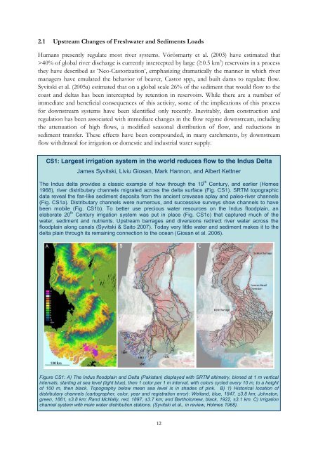
CS1: Largest irrigation system in the world reduces flow to the Indus <strong>Delta</strong><br />
James Syvitski, Liviu Giosan, Mark Hannon, <strong>and</strong> Albert Kettner<br />
The Indus delta provides a classic example <strong>of</strong> how through the 19 th Century, <strong>and</strong> earlier (Homes<br />
1968), river distributary channels migrated across the delta surface (Fig. CS1). SRTM topographic<br />
data reveal the fan-like sediment deposits from the ancient crevasse splay <strong>and</strong> paleo-river channels<br />
(Fig. CS1a). Distributary channels were numerous, <strong>and</strong> successive surveys show channels to have<br />
been mobile (Fig. CS1b). To better use precious water resources on the Indus floodplain, an<br />
elaborate 20 th Century irrigation system was put in place (Fig. CS1c) that captured much <strong>of</strong> the<br />
water, sediment <strong>and</strong> nutrients. Upstream barrages <strong>and</strong> diversions redirect river water across the<br />
floodplain along canals (Syvitski & Saito 2007). Today very little water <strong>and</strong> sediment makes it to the<br />
delta plain through its remaining connection to the ocean (Giosan et al. 2006).<br />
Figure CS1: A) The Indus floodplain <strong>and</strong> <strong>Delta</strong> (Pakistan) displayed with SRTM altimetry, binned at 1 m vertical<br />
intervals, starting at sea level (light blue), then 1 color per 1 m interval, with colors cycled every 10 m, to a height<br />
<strong>of</strong> 100 m, then black. Topography below mean sea level is in shades <strong>of</strong> pink. B) 1) Historical location <strong>of</strong><br />
distributary channels (cartographer, color, year <strong>and</strong> registration error): Weil<strong>and</strong>, blue, 1847, ±3.8 km; Johnston,<br />
green, 1861, ±3.8 km; R<strong>and</strong> McNally, red, 1897, ±3.7 km; <strong>and</strong> Bartholomew, black, 1922, ±3.1 km. C) Irrigation<br />
channel system with main water distribution stations. (Syvitski et al., in review, Holmes 1968).<br />
12