Dynamics and Vulnerability of Delta Systems - loicz
Dynamics and Vulnerability of Delta Systems - loicz
Dynamics and Vulnerability of Delta Systems - loicz
You also want an ePaper? Increase the reach of your titles
YUMPU automatically turns print PDFs into web optimized ePapers that Google loves.
<strong>Delta</strong> plains contain valuable ecosystems, which are lost at astonishing rates due to humaninduced<br />
changes (Richards 1990, Coleman et al. 2008). On the North-American continent the<br />
rates <strong>of</strong> l<strong>and</strong> loss in the Mississippi delta area, which contains about 40% <strong>of</strong> the wetl<strong>and</strong>s in the<br />
USA, are the most striking. Louisiana lost 3,460 km 2 <strong>of</strong> coastal wetl<strong>and</strong>s to open water between<br />
1956-1990, <strong>and</strong> continues to lose between 65-91 km 2 every year (Bourne 2000). USGS scientists<br />
reported that Hurricane Katrina alone caused l<strong>and</strong>loss <strong>of</strong> 388 km 2 (Barras 2006). Because the<br />
major Mississippi channels are constrained between high levees <strong>and</strong> do not bring in fresh<br />
sediments into the deltaic floodplain anymore natural subsidence in the delta is compounded by<br />
reduced sediment supply. In addition, navigation channels have increased saltwater intrusion into<br />
the marshes causing massive ‘brown-outs’ <strong>of</strong> dying freshwater vegetation.<br />
In other deltas worldwide, major infrastructural changes are still underway, like e.g. the<br />
construction <strong>of</strong> a shipping channel in the Ukraine part <strong>of</strong> the Danube delta, which will likely<br />
affect fish <strong>and</strong> wetl<strong>and</strong> bird habitats (Schiermeier 2004). The two major causes <strong>of</strong> global deltaic<br />
wetl<strong>and</strong> loss are expansion <strong>of</strong> open water in the delta plain <strong>and</strong> expansion <strong>of</strong> agricultural <strong>and</strong><br />
industrial l<strong>and</strong>-use. Satellite images <strong>of</strong> 14 major world deltas show all experienced net wetl<strong>and</strong><br />
loss over the last 15-20 years (Coleman et al. 2008). Conversion to agricultural or industrial l<strong>and</strong><br />
was predominant in the developing world, e.g. the Ganges-Brahmaputra <strong>and</strong> Indus deltas saw the<br />
most wetl<strong>and</strong> loss due to human development. Drowning l<strong>and</strong>s <strong>and</strong> increase in open water was<br />
predominant in Arctic deltas as well as some tropical systems, but those estimates are severely<br />
hampered by natural inter- <strong>and</strong> intra-annual variability in st<strong>and</strong>ing water in the delta plain.<br />
CS2: Engineering distributary channels in the Yellow River delta<br />
James Syvitski <strong>and</strong> Yoshiki Saito<br />
Humans have influenced the evolution <strong>of</strong> the Yellow River delta for over 2,500 years. The Yellow<br />
River is known for carrying large amounts <strong>of</strong> sediment from the Loess Plateau that allow rapid<br />
aggradation in floodplain <strong>and</strong> delta. Frequent devastating flooding, largely due to the elevated<br />
riverbed in the delta, has earned the Yellow River the unenviable name “China's Sorrow”. The<br />
sediment load <strong>of</strong> the Yellow River has changed dramatically over time. The pristine sediment load <strong>of</strong><br />
the Yellow River was ~0.1 BT/y prior to 2000 years BP. Due to accelerated soil erosion on the Loess<br />
Plateau, the load increased to ~1 BT/y about 1000 years BP, reaching a maximum level <strong>of</strong> ~1.8 BT/y<br />
in the 1950’s. Since then the load has steadily decreased back to its pristine level <strong>of</strong> ~0.1 BT/y,<br />
largely related to interception <strong>of</strong> the sediment load by upstream dams, <strong>and</strong> reduction in the water<br />
discharge to the delta (Wang et al. 2007).<br />
The Yellow River is one <strong>of</strong> the most dramatic examples <strong>of</strong> humans directing the river course to mitigate<br />
floods <strong>and</strong> claim l<strong>and</strong> for infrastructure. In 1855, a breach in the Tongwaxiang dike, Henan<br />
province, changed the course <strong>of</strong> the Huanghe artificially, from discharging into the Yellow Sea to discharging<br />
into the Bohai Sea. Once rerouted, the main-stem distributary channel avulsed <strong>and</strong> formed<br />
a fan shape from its apex near the town <strong>of</strong> Ninghai <strong>and</strong> later Yuwa in the delta area at a rate <strong>of</strong> ca.<br />
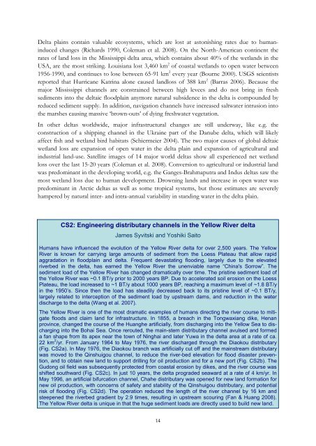
22 km 2 /yr. From January 1964 to May 1976, the river discharged through the Diaokou distributary<br />
(Fig. CS2a). In May 1976, the Diaokou branch was artificially cut <strong>of</strong>f <strong>and</strong> the mainstream distributary<br />
was moved to the Qinshuigou channel, to reduce the river-bed elevation for flood disaster prevention,<br />
<strong>and</strong> to obtain new l<strong>and</strong> to support drilling for oil production <strong>and</strong> for a new port (Fig. CS2b). The<br />
Gudong oil field was subsequently protected from coastal erosion by dikes, <strong>and</strong> the river course was<br />
shifted southward (Fig. CS2c). In just 10 years, the delta prograded seaward at a rate <strong>of</strong> 4 km/yr. In<br />
May 1996, an artificial bifurcation channel, Chahe distributary was opened for new l<strong>and</strong> formation for<br />
new oil production, with concerns <strong>of</strong> safety <strong>and</strong> stability <strong>of</strong> the Qinshuigou distributary, <strong>and</strong> potential<br />
risk <strong>of</strong> flooding (Fig. CS2d). The operation reduced the length <strong>of</strong> the river channel by 16 km <strong>and</strong><br />
steepened the riverbed gradient by 2.9 times, resulting in upstream scouring (Fan & Huang 2008).<br />
The Yellow River delta is unique in that the huge sediment loads are directly used to build new l<strong>and</strong>.<br />
14


