

ALPMON FINAL REPORT - ARC systems research
ALPMON FINAL REPORT - ARC systems research
ALPMON FINAL REPORT - ARC systems research

Create successful ePaper yourself
Turn your PDF publications into a flip-book with our unique Google optimized e-Paper software.
Contract ENV4-CT96-0359 <strong>ALPMON</strong><br />
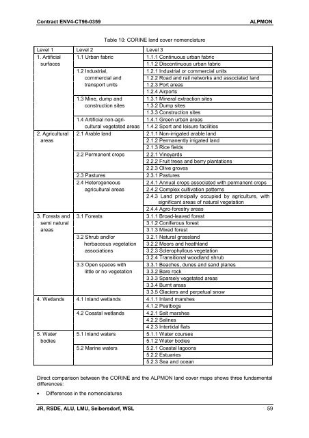
Table 10: CORINE land cover nomenclature<br />
Level 1 Level 2 Level 3<br />
1. Artificial 1.1 Urban fabric 1.1.1 Continuous urban fabric<br />
surfaces 1.1.2 Discontinuous urban fabric<br />
1.2 Industrial, 1.2.1 Industrial or commercial units<br />
commercial and 1.2.2 Road and rail networks and associated land<br />
transport units 1.2.3 Port areas<br />
1.2.4 Airports<br />
1.3 Mine, dump and 1.3.1 Mineral extraction sites<br />
construction sites 1.3.2 Dump sites<br />
1.3.3 Construction sites<br />
1.4 Artificial non-agri- 1.4.1 Green urban areas<br />
cultural vegetated areas 1.4.2 Sport and leisure facilities<br />
2. Agricultural 2.1 Arable land 2.1.1 Non-irrigated arable land<br />
areas 2.1.2 Permanently irrigated land<br />
2.1.3 Rice fields<br />
2.2 Permanent crops 2.2.1 Vineyards<br />
2.2.2 Fruit trees and berry plantations<br />
2.2.3 Olive groves<br />
2.3 Pastures 2.3.1 Pastures<br />
2.4 Heterogeneous 2.4.1 Annual crops associated with permanent crops<br />
agricultural areas 2.4.2 Complex cultivation patterns<br />
2.4.3 Land principally occupied by agriculture, with<br />
significant areas of natural vegetation<br />
2.4.4 Agro-forestry areas<br />
3. Forests and 3.1 Forests 3.1.1 Broad-leaved forest<br />
semi natural 3.1.2 Coniferous forest<br />
areas 3.1.3 Mixed forest<br />
3.2 Shrub and/or 3.2.1 Natural grassland<br />
herbaceous vegetation 3.2.2 Moors and heathland<br />
associations 3.2.3 Sclerophyllous vegetation<br />
3.2.4 Transitional woodland shrub<br />
3.3 Open spaces with 3.3.1 Beaches, dunes and sand planes<br />
little or no vegetation 3.3.2 Bare rock<br />
3.3.3 Sparsely vegetated areas<br />
3.3.4 Burnt areas<br />
3.3.5 Glaciers and perpetual snow<br />
4. Wetlands 4.1 Inland wetlands 4.1.1 Inland marshes<br />
4.1.2 Peatbogs<br />
4.2 Coastal wetlands 4.2.1 Salt marshes<br />
4.2.2 Salines<br />
4.2.3 Intertidal flats<br />
5. Water 5.1 Inland waters 5.1.1 Water courses<br />
bodies 5.1.2 Water bodies<br />
5.2 Marine waters 5.2.1 Coastal lagoons<br />
5.2.2 Estuaries<br />
5.2.3 Sea and ocean<br />
Direct comparison between the CORINE and the <strong>ALPMON</strong> land cover maps shows three fundamental<br />
differences:<br />
� Differences in the nomenclatures<br />
JR, RSDE, ALU, LMU, Seibersdorf, WSL 59

