

ALPMON FINAL REPORT - ARC systems research
ALPMON FINAL REPORT - ARC systems research
ALPMON FINAL REPORT - ARC systems research

You also want an ePaper? Increase the reach of your titles
YUMPU automatically turns print PDFs into web optimized ePapers that Google loves.
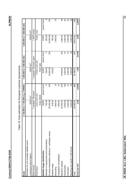
Contract ENV4-CT96-0359 <strong>ALPMON</strong><br />
Table 16: Cost estimation for European customer requirements.<br />
Scale 1:50.000 to 1:100.000 (e.g. CORINE) 1:250.000 to 1:500.000 (AC) 1:250.000 to 1:500.000 (AC)<br />
592200 km 2<br />
32400 km 2<br />
Estimation for one complete satellite scene<br />
covering an area of approx. 32400 km 2<br />
Data sources 1 Landsat7 TM scene 1 Landsat7 TM scene, geoc. 1 WIFS scene<br />
Parameters Land cover and Forest cover and Forest cover<br />
forest details forest type<br />
Satellite image classification EURO person hours EURO person hours EURO person hours<br />
Definition of requirements and nomenclature 750,00 11 750,00 11 250,00 4<br />
Air-photo interpretation (reference + verification areas) 25.000,00 379 10.000,00 152 10.000,00 152<br />
Satellite image 618,00 618,00 763,00<br />
Geocoding 1.800,00 27 1.800,00 27<br />
Topographic normalisation 1.800,00 27<br />
Signature analysis 20.000,00 303 10.000,00 152 3.000,00 45<br />
Classification 9.000,00 136 4.000,00 61 4.000,00 61<br />
Verification 4.000,00 61 4.000,00 61 4.000,00 61<br />
Reporting and results in GIS format 3.000,00 45 3.000,00 45 3.000,00 45<br />
Total 65.968,00 990 32.368,00 481 26.813,00 395<br />
Costs per km 2<br />
2,04 0,0306 1,00 0,0148 0,05 0,0007<br />
JR, RSDE, ALU, LMU, Seibersdorf, WSL 69

